Just a quick afternoon update to note that the forecast for Tropical Storm Barry has not changed appreciably today. While it shows some signs of getting its act together, the strongest winds remain far from the storm’s center. As of 4pm CT maximum sustained winds are 40mph.
The latest model guidance continues to suggest that either a strongish tropical storm (more likely), or possibly a weak hurricane, will move into Louisiana on Saturday. The primary threat is heavy rains, with the potential for an additional 10 to 20 inches of rainfall across already sodden areas. Of further concern is that the Mississippi River is already swollen due to drainage from flooded Midwestern areas. Finally, there is the threat of storm surge, particularly along the Atchafalaya River and Shell Beach.
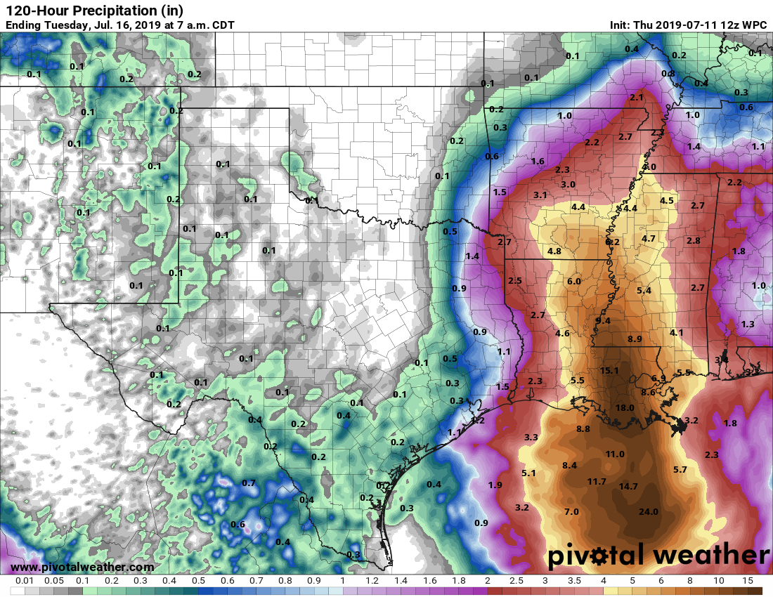
NOAA rain accumulation forecast for now through Monday. (Pivotal Weather)
In regard to Barry, the greater Houston area should remain in the clear, with only perhaps 40 to 50 percent rain chances this weekend—higher near the coast, lesser inland—and probable accumulations of 1 inch or less. Galveston will be more susceptible to higher winds and thunderstorms this weekend than, say, Katy, but the entire Houston region is likely to lie on the far periphery of Barry’s action. Tides are unlikely to be a significant problem, although rip currents could be problematic.
We just wanted to offer up a quick update this morning to let you know that Invest 92L, or Potential Tropical Cyclone #2 has now been declared officially as Tropical Storm Barry in the Gulf.
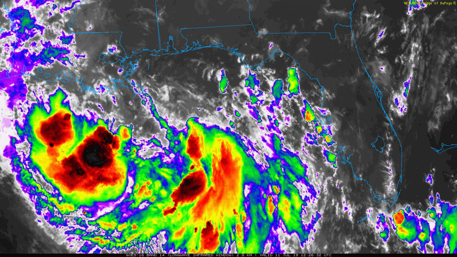
Satellite imagery shows a system struggling to consolidate, but it has organized enough to be classified as a tropical storm. (College of DuPage)
Maximum sustained winds are 40 mph as of the 10 AM CT National Hurricane Center advisory. The system is still struggling a bit to organize this morning, but now has a better defined center, enough so to be classified as a tropical entity. Most of the storms are displaced to the south and west of the center. Over the next 24 hours, the satellite presentation of Barry should improve, and slow strengthening should commence.
For us in Houston, the good news is that we remain outside the forecast cone, unlikely to see any significant impacts from what should become Tropical Storm Barry.
The National Hurricane Center forecast for Barry was nudged even a bit farther to the east this morning. (NOAA/NHC)
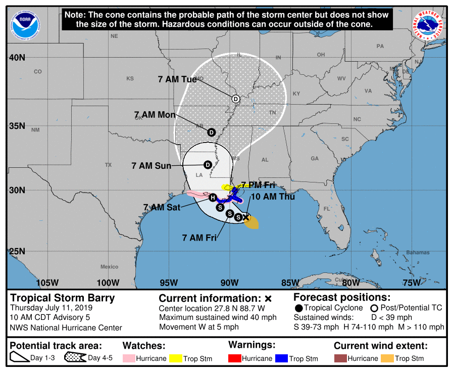
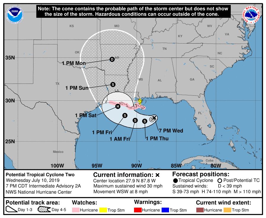
The National Hurricane Center is bringing Barry somewhere between Cameron & New Orleans on Saturday as a category 1 hurricane. Hurricane Watches remain hoisted from Cameron to the mouth of the Mississippi River. Tropical Storm Warnings are now up for the Louisiana coast east of Morgan City. For folks in Louisiana, this will be a tropical system, yes, but the main story will probably remain the rains that will fall, regardless if this remains a weak tropical storm or strengthens into moderate or strong tropical storm or hurricane. Those rains will all be capable of producing widespread flooding problems in the eastern half of the state and perhaps in Mississippi, should the storm shift any farther to the east.
Here in Houston, just keep tuned to the forecast, especially if you are traveling anywhere east of the region this weekend. Otherwise, expect some showers and storms to pop up this afternoon or evening. Some of the storms could be locally heavy.
Good morning. As of 4am CT, the system in the Gulf of Mexico has nearly organized into a tropical depression (named Barry), and likely will become one later this morning or early this afternoon. While Texas isn’t entirely out of the woods, as there remains some uncertainty in the track and intensity forecast, this increasingly looks like a threatening situation for Louisiana. Because the state is next to Texas, and we have received so many questions from people living in, or traveling through Louisiana, we will continue to offer comprehensive coverage of Barry as the storm develops. If you’re living in Houston, please continue to pay attention to forecasts for the next couple of days, as tropical weather invariably offers up surprises. However, it’s probably safe to go about your business as usual this weekend.
Satellite image of the tropical system shortly after 3am CT Thursday. (NOAA)
Track
Confidence is increasing in the forecast track for a couple of reasons. First of all, we’re now likely only about 2.5 days away from landfall (likely along the Louisiana coast between Lake Charles and New Orleans), and errors for such a storm are typically less than 100 miles, even given the uncertainty with Barry. Secondly, although Barry has not yet formed a distinct center of circulation, there is nonetheless a decent clustering of ensemble members of the global models around such a solution. So a Louisiana landfall is likely for Barry, but not a certainty.
National Hurricane Center track forecast for the Gulf system as of 4am CT Thursday.
Intensity
Because Barry has not yet organized into a tropical storm, and perhaps only has a couple of days remaining sufficiently offshore, this should help to set a limit on its intensity. The official forecast still brings Barry to minimal Category 1 hurricane status prior to landfall, but confidence isn’t particularly high.
So I just wanted to freshen up the site with a quick overview of what’s happening this evening and table set for tomorrow morning, when we should begin to give some more confident answers on impact risks to our area.
Now
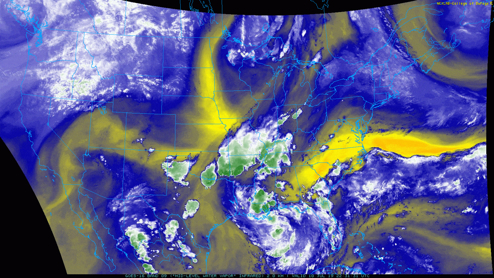
I want to point out some of the key features to watch on a water vapor satellite image.
A satellite loop of water vapor shows several features we will be watching. (College of DuPage)
First, over the Desert Southwest, you can sort of see yellow color lifting north slowly. That’s the ridge of high pressure which will play a role in steering presumed future Barry. To the north, over Minnesota and Iowa, the yellow color beginning to dig south and east represents a trough in the upper atmosphere that will act to try and “pick up” Barry, drawing it to land. The ballet between these features, combined with where the storm eventually coalesces will determine whether this is indeed a Louisiana storm, as most modeling suggests, or if it could make its way far enough west toward Texas. We will learn much more about this overnight.
Where is that center?
Well, according to this tweet from one of the hurricane hunters, it’s still too broad to be easily defined:
Based on the most recent observations from the aircraft out there this evening, however, they may finally be on to something near 27.5 N/87.5 W, or a little bit south and east of where the National Hurricane Center had been initializing things. If that is the case, that would not be drastically farther south than expected, meaning I would feel a smidge better about the “miss Houston to the east” scenario being realistic. That said, strange things can happen overnight, so let’s watch and see what’s what tomorrow morning.
Evening models
A new batch of modeling comes out in the evening that we don’t use a ton, but we can still use to look for trends. Indeed, those models did trend back to the west a bit, but not as far as it looked this morning. What does this mean? Model consensus is still very much pointing toward a Louisiana landfall, keeping most impacts to our east. Thus we have no issues with the official forecast from the National Hurricane Center.
This evening’s forecast will be refreshed around 10 PM CT, and it may wiggle a bit to the east. (NOAA)
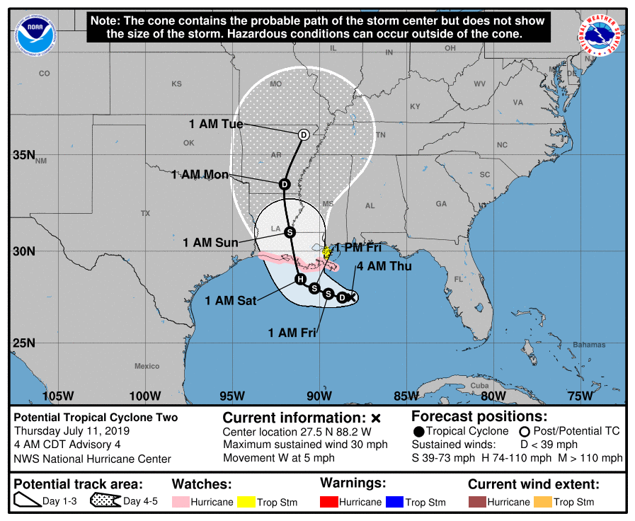
The NHC forecast for “Potential Tropical Cyclone Two” shows landfall between Cameron, LA and Vermilion Bay, but the cone obviously extends further to the eastern side of Houston on the left and east to near New Orleans on the right. Hurricane Watches were hoisted late today, extending from Cameron, LA east to the mouth of the Mississippi River. I would expect a tropical storm or hurricane watch to be extended west overnight, perhaps all the way to High Island, TX (northeast of Bolivar).
One word of note: If you have friends or relatives in the eastern half of Louisiana or your travels will take you through there between late Friday and Sunday morning, please make sure everyone is staying on top of the latest with this system. This has the potential to be a very serious rain and flooding event for that region, including Baton Rouge and New Orleans.
So for folks in Houston: You can go to sleep tonight knowing that no data this evening has increased our odds of being significantly impacted by this storm. But given a lingering degree of uncertainty, you absolutely will want to check back in on the forecast tomorrow morning to see what, if anything, may have changed overnight.
Eric has you covered in the AM, and I just want to offer him a mention of gratitude for stepping up to spell me so we can maintain continuous coverage through the storm.