Answering some questions about the late week tropical system

You had questions, we’ve got (some) answers. With the potential of a tropical system (also referred to as Invest 92L or “future Barry”) in the Gulf later this week, I thought I would do a reader-driven Q&A. I looked at comments from our morning post and asked on Twitter what questions folks had, and I’ve chosen some to answer here. I can’t get to a lot of questions in the comments, especially on Facebook, unfortunately simply because of time. So I apologize for that, but hopefully most of what people are wondering will be answered in our at least twice daily posts going forward.

I am traveling from X to Y and I want to know what weather I will encounter. Can you help?

I need to answer this one right out of the gate because based on the volume of questions I’ve seen, it would seem all of Texas is on a beach between New Orleans and Panama City this week. Here is what I can tell you: Given the current forecast, it’s going to be a bit of a stormy period along most of the Gulf Coast between Lafayette, LA and the Panhandle. So expect showers and storms each day scattered about with heavy rain possible in spots, especially Thursday and Friday. I do think travel across Louisiana is going to be challenging later Friday and Saturday before whatever this thing is moves ashore and begins to pull away.

The NWS forecast for Saturday morning shows a tropical system parked south of Sabine Pass, which would likely mean heavy rain along a wide swath of southern Louisiana Saturday. Travel may be problematic there. (NWS WPC)

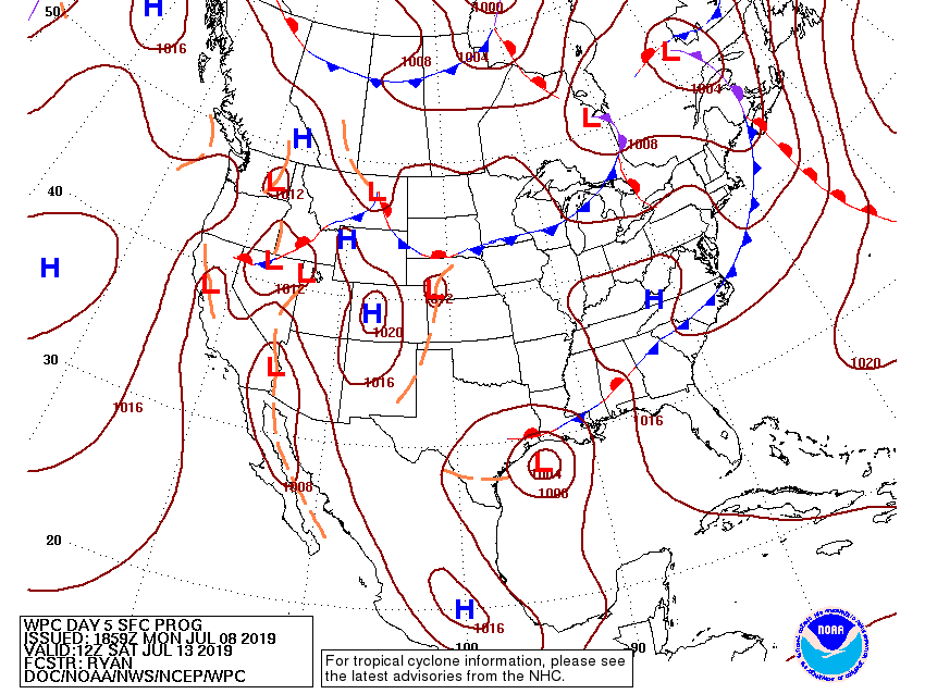
Houston would likely be free of any serious issues through at least Friday. So if you have travel plans between Houston and points east, it will get progressively worse Thursday into Friday, peak on Saturday or early Sunday, and gradually improve beyond that. That’s the best we can tell you right now.

Do I need to panic? Is this another Harvey? How much rain?

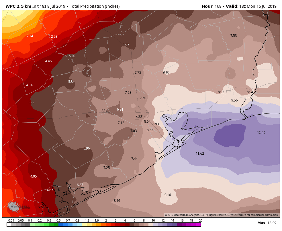
I mentioned this in our morning post, but it needs a bit more prominence here: No, this is not another Harvey. No, you don’t need to panic. You do need to stay aware, however. That storm was unique, and it would take a truly special set of circumstances to see that again. That being said: We always tell you that no two flood events are alike. Whenever there is a risk of heavy rain, there is a risk of flooding in Houston. It will be its own unique event, and given the current rainfall forecast of 5 to 15 inches in the wide region between southeast Texas and southwest Louisiana, yes flooding is a distinct possibility.

The official rainfall forecast has been upgraded today, calling for a widespread 5-15″ on average in and east of our region. This will be adjusted and change with time, but this sort of rain will likely cause some flooding issues in some to be determined places. (NWS WPC via Weather Bell)

Thankfully, this storm should be moving steadily, so we do not believe it will linger down here for 5 days, though storm chances will remain in the forecast into next week. This rain forecast will be fine-tuned in the next few days, so expect some changes, but prepare as if we will be dealing with a heavy rain event in the area this weekend.

See full post

Quiet start to week, but monitoring the Gulf by the weekend

The weekend went about as advertised across southeast Texas with heat and humidity and a distinct lack of rain showers most of the time. We generally topped off in the mid-90s, with warm mornings. Much of this week is likely to play out in a similar fashion. It’s the end of the week when things get more difficult and possible forecast outcomes vary vastly as we will explain below.

Today & Tuesday

We expect both days to carry over the weekend weather: Expect sunshine and hot temperatures. An isolated shower can’t entirely be ruled out, but consider yourself lucky if you see one. We should do mid-90s today and middle to even upper-90s tomorrow.

High temperatures today will sizzle once again. (NWS via Weather Bell)

Take your usual heat precautions the next couple days, as heat index values should top off around 105°, and a few places may flirt with heat advisory criteria.

Wednesday & Thursday

Forecast confidence begins to slump backwards a bit for midweek. As of now, Wednesday looks similar to Tuesday, with mid- to upper-90s and high humidity, sunshine, and limited to nil rain chances. Thursday becomes more challenging. The disturbance to our east in the Gulf of Mexico will determine if we again reach for the upper-90s with dry weather or if we do low- to mid-90s and increasing scattered shower chances. We should hopefully have some clarity on this tomorrow.

See full post

As quiet a summer weekend as Houston ever sees

As promised, things quieted down nicely on the Fourth after some morning fireworks. This time of year, it’s always difficult to say whether it’s good news or bad news to have “nice” weather for an extended stretch. Those cooling showers can be welcome in midsummer, but we will be void of them almost completely through the weekend. Stick with us til the end of today’s post as we will discuss some possible tropical mischief in the Gulf for late next week.

Today & weekend

Basically, if you have outdoor plans this weekend, your only concern will be heat. Expect sunshine in heaping quantities today, tomorrow, and Sunday. A shower is always possible in summer, but almost all of us should be dry through the weekend. We will see high temperatures in the mid-90s and lows bottoming out in the mid-70s the next few days. Humidity, as it always is in summer, will be high across the region. So, just take it easy and stay hydrated this weekend.

Monday & Tuesday

We will probably see an extension of this dry, sunny, hot pattern into early next week. Expect ample sunshine and only very, very minor shower chances Monday and Tuesday. We will call it more mid-90s both days with mid- to upper-70s for lows.

The rainfall forecast for the next 5 days over Texas. Can you find the area of high pressure? (NOAA via Pivotal Weather)

Yeah, it looks pretty dry the next 5 days.

See full post

One more wet day, then high pressure begins to take control

The overall pattern remains more or less the same. We’re going to have one more potentially wet day—although as we saw Tuesday, these showers are most definitely hit or miss—before things begin to dry out on the Fourth of July and then remain that way for awhile.

Wednesday

We’re still feeling the effects of tropical moisture pushing in from the Gulf of Mexico, and some of the high-resolution models are fairly bullish on rain totals for today. But at the same time, there’s no significant forcing to really generate sustained, heavy rainfall. So I think like we saw Tuesday, there may be a few isolated areas that see 3 inches of rain, but for the most part, most of the city should see 1 inch of rain or less. In any case, the biggest threat is probably some brief street flooding. We’ve got one more day with potential highs in the 80s before Houston begins to experience more typical summertime heat.

The HRRR model shows the potential for scattered, strong storms at 1pm Wednesday. (Weather Bell)

Fourth of July

Rain chances for Houston will fall down to below 20 percent, but we can’t entirely rule out some daytime showers. An atmospheric disturbance will linger north of the region, so areas along and north of Texas 105 may see better rain chances during the daytime. With partly sunny skies, highs probably will get into the low 90s for most of Houston. Almost everyone should see partly cloudy skies, temperatures in the 80s, and no rain for fireworks.

See full post