On Wednesday, for Houston’s now-daily game of rainfall roulette, the Inner Loop area of the city generally “won” the contest with 2 to 3 inches of rainfall. Meanwhile, most of the suburbs were dry, or saw only a few raindrops. This pattern will likely continue through the work week, although the intensity of storms today and Friday hopefully won’t be quite so high.
Thursday
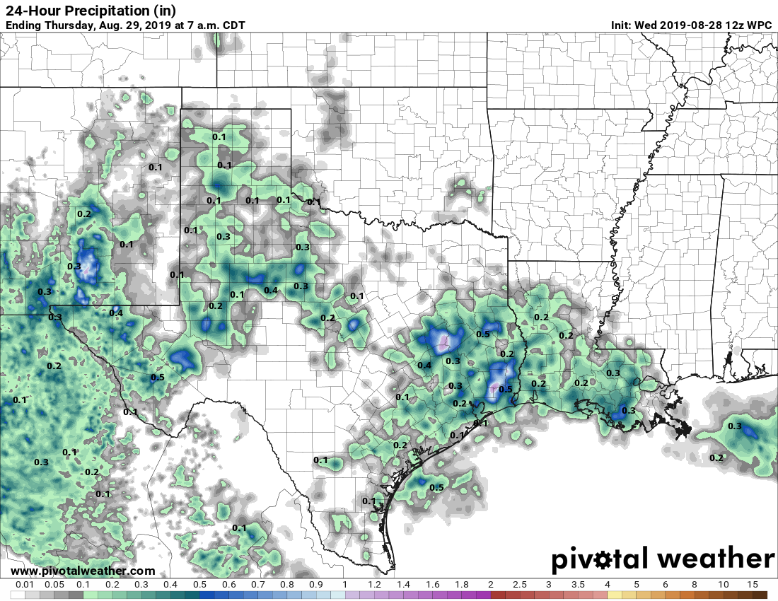
Today will be hot and mostly sunny, with high temperatures in the mid-90s. We’ll see our usual ramp up in storm activity this afternoon, but high-resolution models indicate that storms won’t be as widespread or as intense as Wednesday. As usual, storms should wane with the loss of daytime heating, and nighttime temperatures probably won’t fall much below 80.
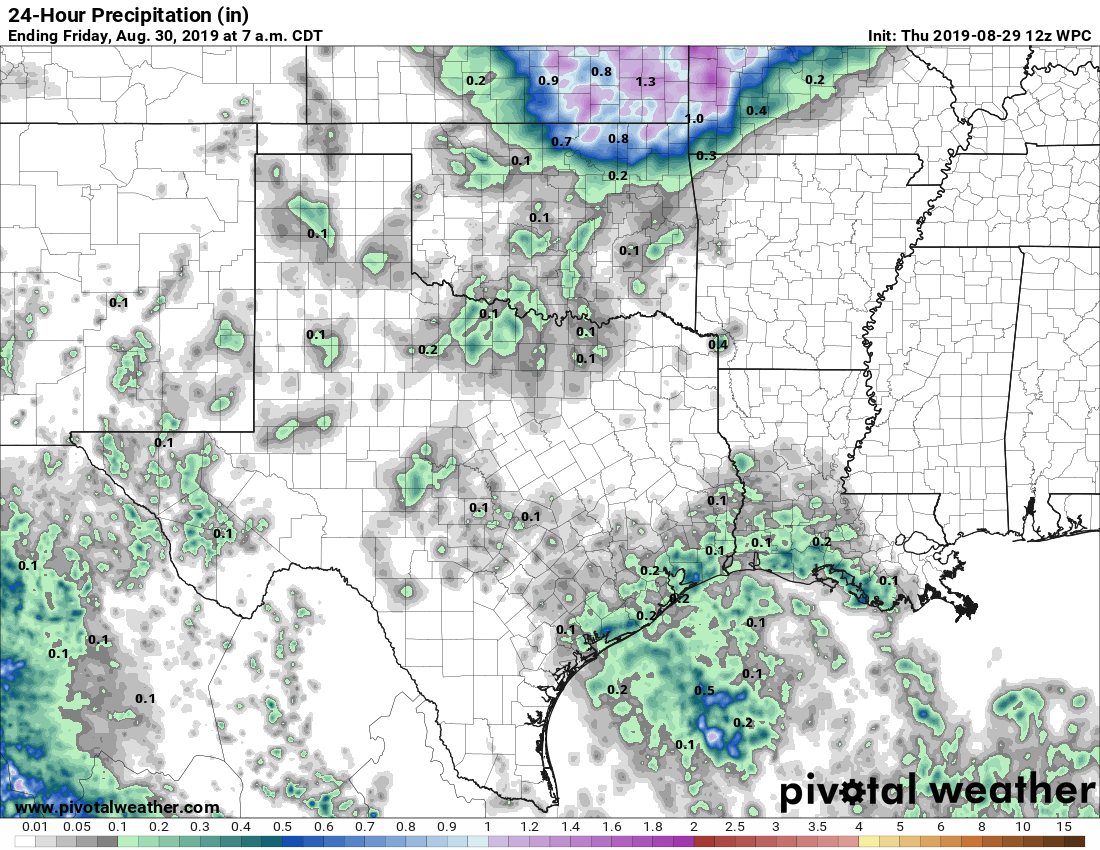
Rain chances on Thursday will be a little better along the coast. (Pivotal Weather)
Friday
Another day like Thursday, although rain chances may take another step backward, with perhaps only 20 percent coverage during the afternoon and early evening hours.
Saturday and Sunday
Drier air from a dying front should make for a pretty nice—all things considered—Labor Day Weekend. Expect high temperatures in the mid-90s, with mostly sunny skies. Lows at night may get into the mid-70s for central and northern parts of the metro area, so mornings and evenings may be a smidge more pleasant than we’ve seen. Finally, rain chances will be very low.
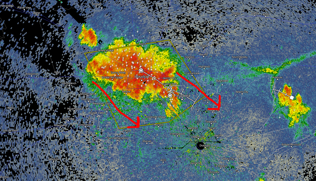
Quick local note: Strong to severe thunderstorms are racing through the Houston metro as of 5:30 PM. We expect these to drop south and east through 7 to 8 PM, bringing much of Houston a burst of heavy rain yielding perhaps 1 to 2 inches, as well as gusty winds. Areas south and east of Houston are likely to see some heavy rain from this as well. Areas north and west of Houston are mostly done with storms now or should be soon. The storms should begin to diminish and shift offshore after sunset.
Radar at 5:30 PM showed miserable conditions for commuters leaving the Inner Loop. Storms will press south and east this evening. (RadarScope)
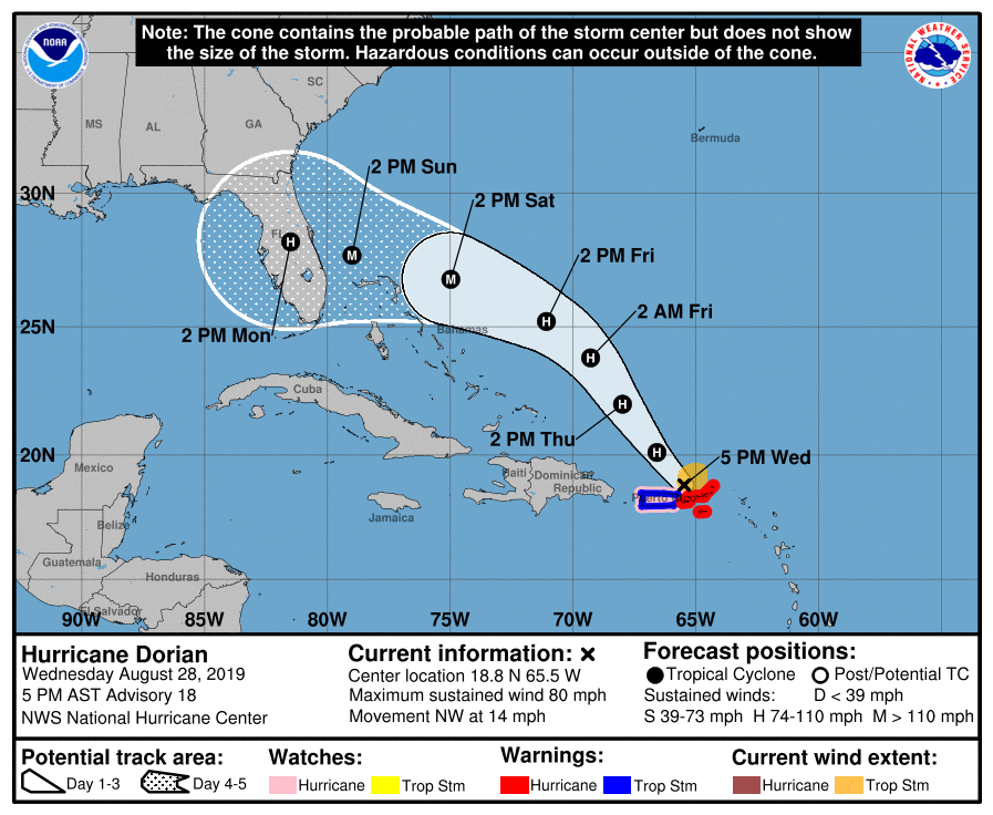
On to the tropics. Interest regarding Hurricane Dorian has spiked today as the track has shifted a bit and the upgrade to a hurricane occurred this afternoon. We’re here to walk you through what the future may have in store regarding Dorian.
One sentence summary
Hurricane Dorian is likely to impact the Florida Peninsula around Labor Day before heading into the eastern Gulf of Mexico where it could impact the eastern or central Gulf Coast next week, east of Texas, though there is still some degree of uncertainty.
Now
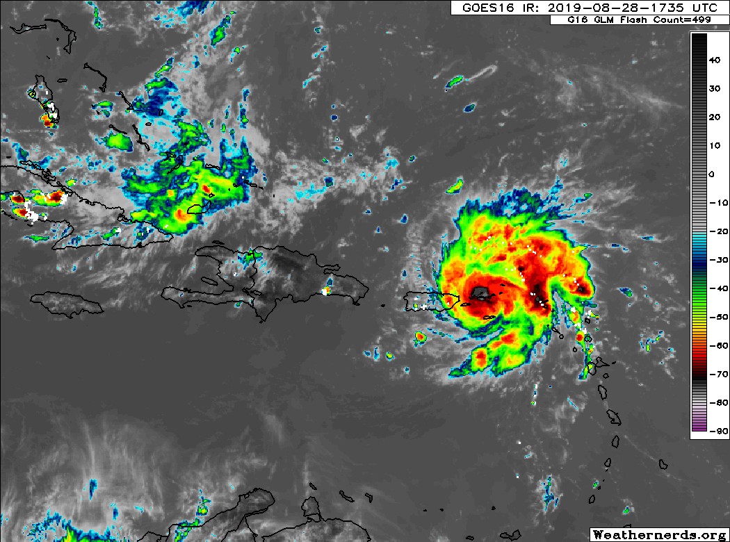
Dorian is located just northwest of St. Thomas in the U.S. Virgin Islands, as of the National Hurricane Center’s (NHC) 4 PM CDT advisory. Satellite shows a fairly healthy looking system that has managed to keep itself together in the face of adverse conditions around the storm.
Hurricane Dorian beginning to exit the Virgin Islands and Puerto Rico on Wednesday evening. (Weathernerds.org)
Dorian’s maximum sustained winds are 80 mph, and it’s currently moving to the northwest at 14 mph.
Through the holiday weekend
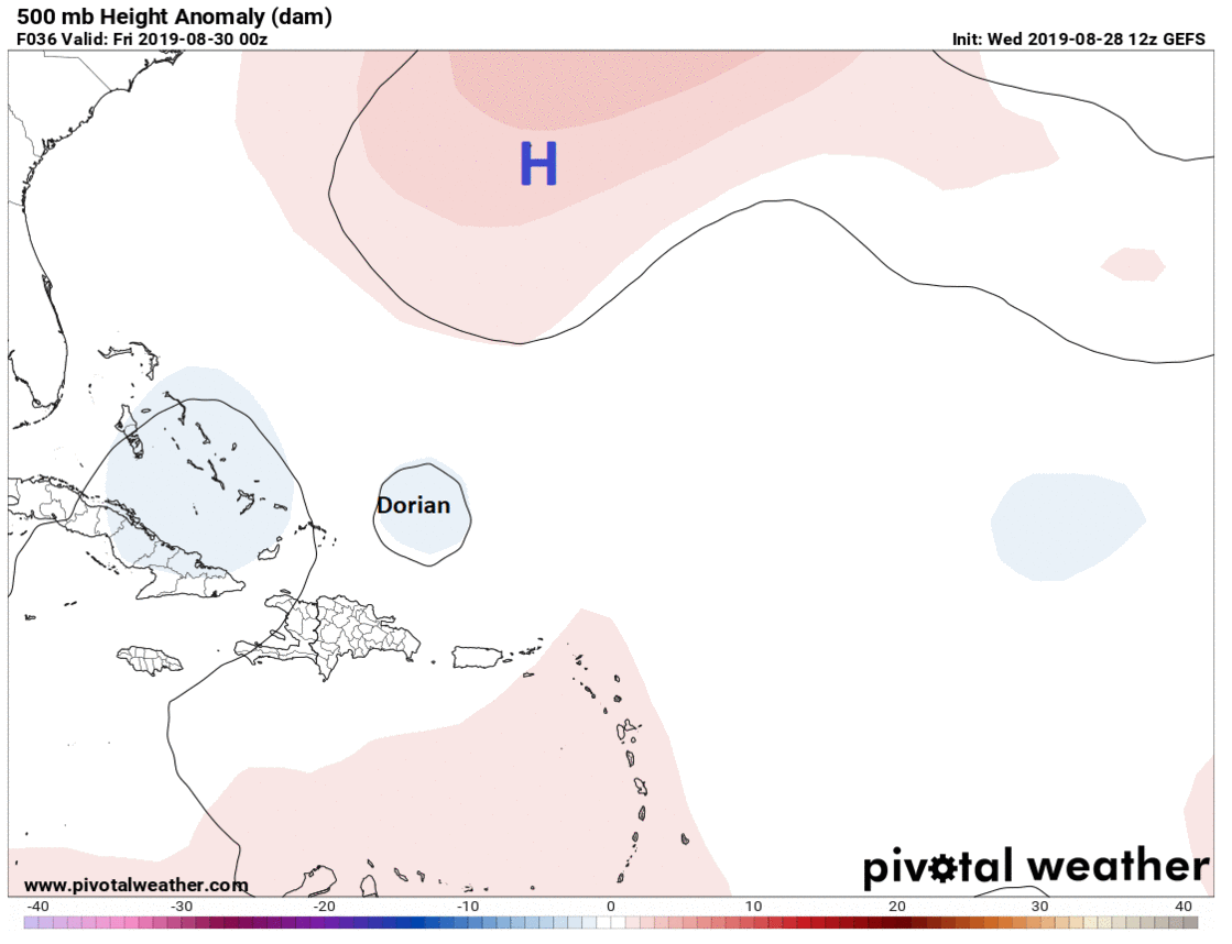
Dorian will take a cruise east of the Bahamas over the next couple days. As this occurs, high pressure over the Atlantic is going to begin building back to the west. This will force Dorian to begin to turn more to the west instead of northwest by the time we get to Friday night or Saturday.
High pressure building from near Bermuda west to the Southeast will force Dorian to turn west toward Florida over the weekend. (Pivotal Weather)
Around this time, forecast uncertainty begins to rapidly increase, unfortunately. The most likely scenario right now indicates that Dorian will remain on a westward heading toward the Florida Peninsula. Whether that’s aimed toward Miami, West Palm, Vero, Melbourne, or somewhere else is contingent on when Dorian turns and how sharp of a turn it is. Thus, you have to assume that at this point, the entirety of the Florida Peninsula needs to monitor Dorian’s progress, and they are all in the cone of uncertainty still.
The NHC forecast for Dorian shows a major hurricane approaching somewhere along the Florida Peninsula on Labor Day. (NOAA)
If you are planning a Labor Day weekend trip anywhere on the Florida Peninsula, you must be aware of this storm and that there is an increasing chance of some kind of impact beginning later Sunday or Labor Day Monday. We can’t tell you specifically what to do, but it’s a scenario you need to be aware of.
Beyond Labor Day
Uncertainty roofs beyond Monday regarding Dorian’s track. Much will depend on what’s happening over the Plains, how strong a trough of low pressure is across the Midwest and Mid-Atlantic, and ultimately how much the high pressure ridge over the Atlantic wants to build back to the west. This means numerous scenarios involving Dorian are in play.
An example of how much uncertainty there is beyond ~ day 3. Each "L" on this @Weathernerds map represents where the 51 Euro ensemble members places Dorian's center on Tues AM. This is a tremendous spread in possibilities, underscoring the need to not take any 1 solution literally pic.twitter.com/ERN1QZy3aP
The most likely scenario at this point, or at least the one favored by most weather models and ensemble members involves Dorian moving into the eastern Gulf of Mexico and then gradually turning to the northwest and north toward the central or eastern portions of the Gulf Coast. While we continue to believe this will not ultimately be a concern for Texas, we should continue to monitor Dorian’s progress through the weekend, especially given the high degree of uncertainty that exists right now. We will gradually gain some color on this tomorrow and Friday and can hopefully completely rule out certain possibilities for us here.
The bottom line on Dorian:
The odds of a major hurricane impacting Florida around Labor Day have increased significantly today.
There is still a high amount of uncertainty on track and exact timing of impacts, and folks from Louisiana through the Carolinas should be watching Dorian closely. In Texas, for now, we should just be checking in once a day to make sure we’re still in the clear.
If you have travel plans to the Florida Peninsula for the holiday weekend, it’s critical you remain tuned in and aware of this storm.
Besides major hurricane impacts in the region wherever the storm hits, extremely heavy rainfall will be possible over Florida and the eastern Gulf Coast or Southeast early to mid-next week.
That other Gulf system
Eric this morning noted the other feature we’re watching: A disturbance near Cuba. We expect that to arrive in the southern Gulf of Mexico this weekend. Weather modeling this afternoon continued to keep that pointed mostly well to our south and either into far south Texas or Mexico by midweek next week. Most also did not suggest it would strengthen a whole lot. Still, given the uncertainty surrounding Dorian and any potential interplay between Dorian and that disturbance (the systems won’t merge, but one could impact the other depending on location and intensity), we are going to continue to watch this one. The disturbance could also become a significant rainmaker for parts of South Texas or Mexico.
The good news is that after these two systems run their course, conditions look quiet in the Gulf again for a little while. More from Eric on Thursday morning.
Good morning. Most of the area remained dry on Tuesday, but there were some sneaky strong showers and thunderstorms in the Clear Lake area that dropped as much as 2-3 inches of rain over a few locations during the afternoon—a good reminder of August’s potential to produce a lot of rainfall quickly in Houston. We’ll fall into a moderately more wet pattern before the weekend dries out. This post will also looks into the tropics, which continue to remain active.
Wednesday
High-resolution models show scattered, but fairly strong showers and thunderstorms developing over parts of the metro area this afternoon and evening. I think the pattern will be similar to that on Tuesday, where a few areas see quite a bit of rain, but most of the region sees a tenth of an inch or less. The day will otherwise be partly sunny, with highs in the mid-90s.
Rain accumulation forecast for Wednesday. (Pivotal Weather)
Thursday and Friday
The pattern will be more or less the same to end the work week, with a dissipating cool front providing an impetus for scattered showers and thunderstorms. Rain chances will be about 40 percent each day. The front won’t have much effect on temperatures, with highs generally in the mid-90s, although lows may fall a few degrees into the upper 70s. So it goes in August.
Summer continues apace this week—for the love of God, is August over yet??—with not much overall change in the forecast. We can expect highs in the upper 90s and lows around 80. Some drier air this weekend may help with nighttime temperatures, but we’re making no promises. We’ll also discuss the tropics in today’s post because it’s that time of year, and the Gulf may see some activity over the next week or so.
Tuesday
We’ll start today with mostly sunny skies, and highs are going to pretty quickly leap up into the mid- or upper-90s. However, it appears as though the sea breeze may be a little more active this afternoon than Monday, with scattered thunderstorms popping in the 2pm-6pm range this afternoon.
Wednesday and Thursday
These should be typical summertime days in Houston, with highs in the upper-90s, and afternoon shower and thunderstorm chances in the 30 percent range. Nights remain warm and sultry and unpleasant.
Monday afternoon dewpoint forecast from the GFS. (Weather Bell)
Labor Day Weekend
If you have outdoor plans, I hope you have included some water in those plans. Yes, a very weak front will approach the region and may reach Houston this weekend. But no, it’s not going to bring much cooling. If you’re far enough west or north of Houston, you may possibly see some dewpoints in the lower 60s or upper 50s on Sunday and Monday, but right now we don’t think this will be all that noticeable in Houston.
For the most part, we’re going to see highs in the upper 90s, mostly sunny skies, and rain chances of 10 to 20 percent each day.