Imelda heading for the exits, but the damage is surely done

Good afternoon, everyone. Before jumping into the forecast, I just wanted to provide some perspective. Since the National Hurricane Center began naming Atlantic storms in 1950, just two tropical storms have had their names retired: Allison, in 2001; and Erika in 2015. Soon we will have three, with Imelda.

Many readers will certainly remember Allison. It made me want to become a meteorologist. Tropical Storm Erika was a prodigious rainmaker that killed 31 people in Dominica and Haiti. There will be time over the coming days to put Imelda into historical perspective. But here are a few quick thoughts:

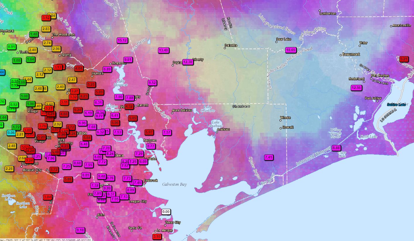
  • For parts of Golden Triangle, the rain intensity and impacts were worse than Hurricane Harvey, which is staggering.
  • For that region, Imelda is overall worse than Tropical Storm Allison was for Houston.
  • And in Houston, this Allison-lite. The heaviest rains (25″+) so far have been in relatively rural parts of Montgomery County. Amazingly, there are locations in Harris County under 1 inch for the entire storm.

Thursday evening

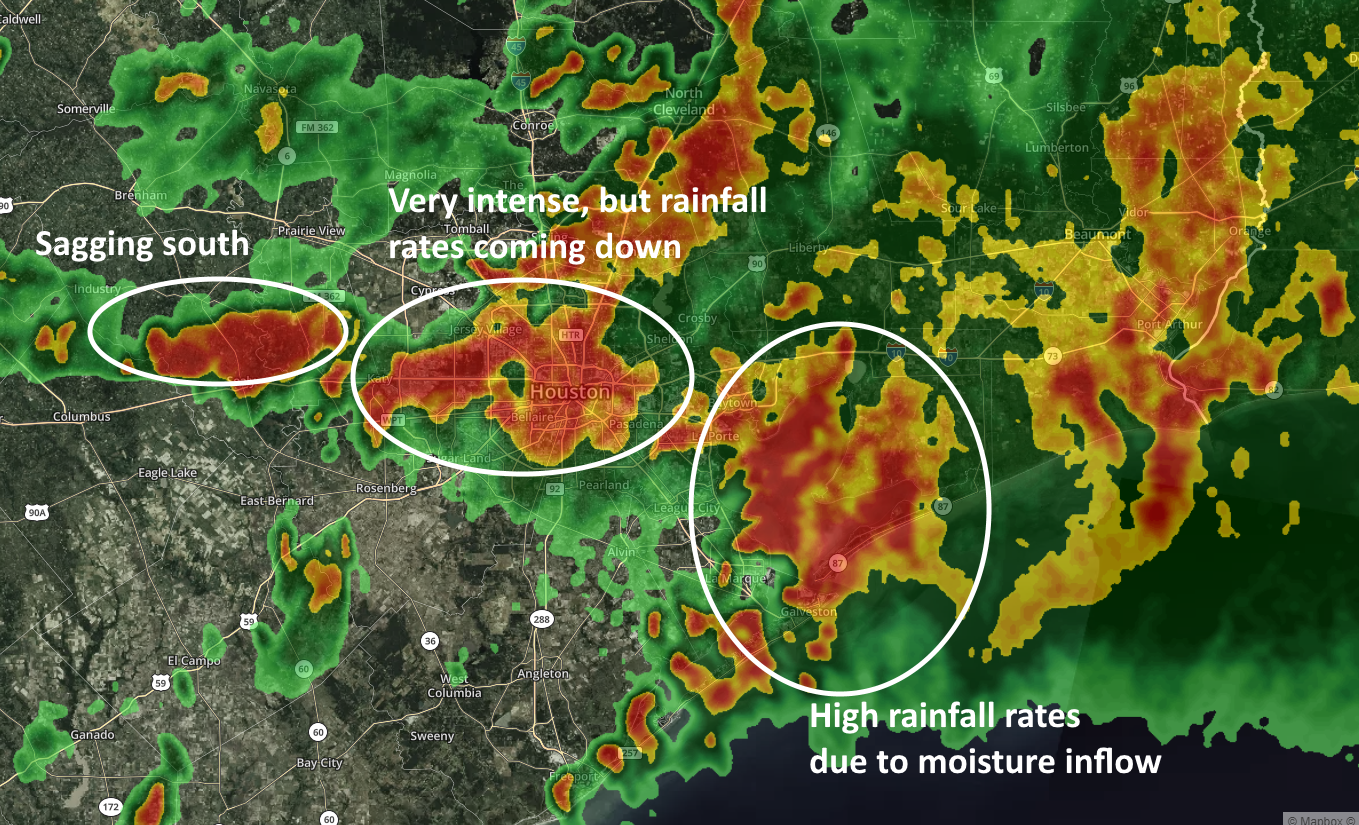
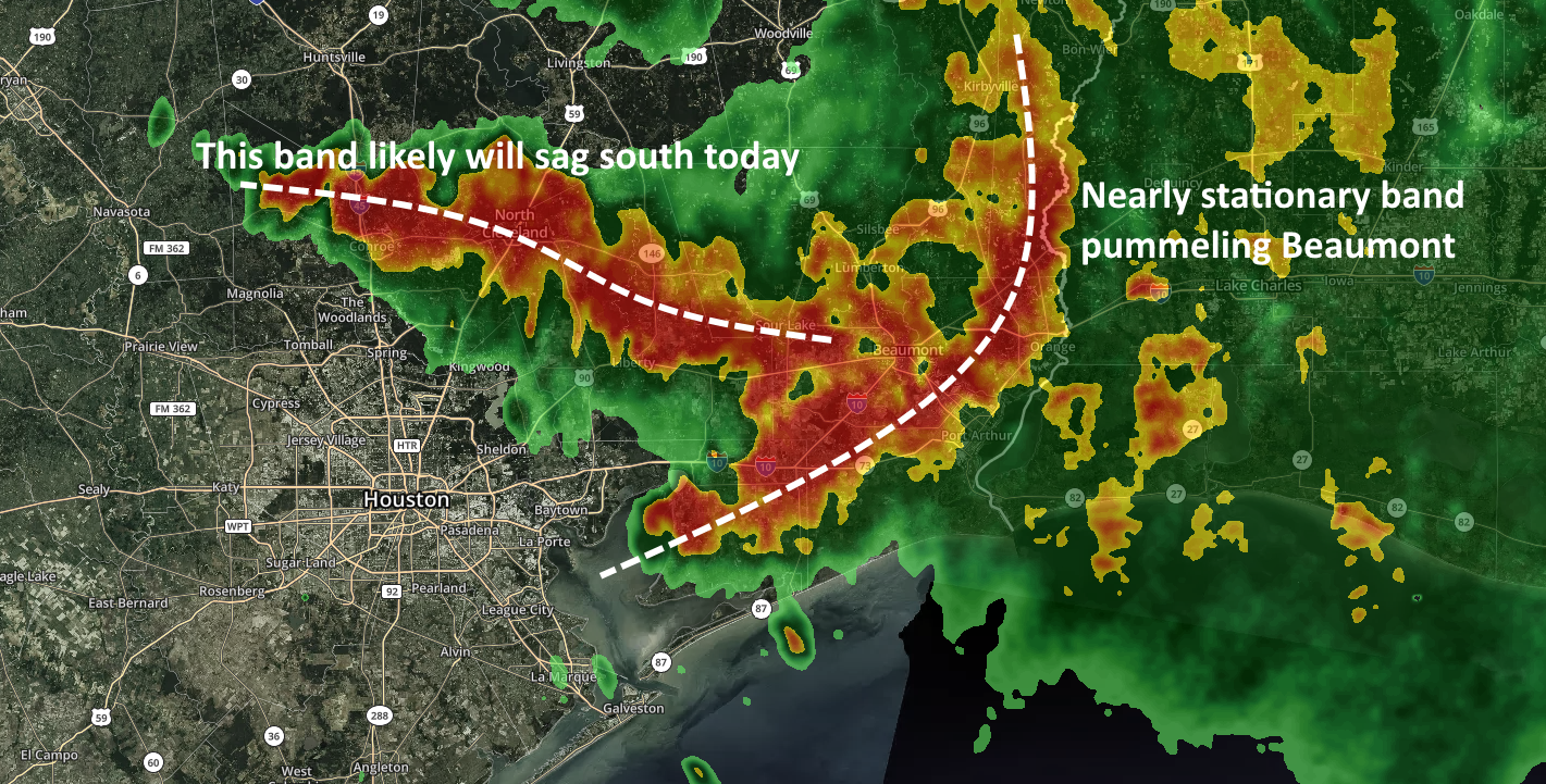
You don’t need a meterologist to tell you that the incredibly productive rainfall band that began this morning in Montgomery and Liberty counties has sagged southward, soaked Harris County, and is now mercifully now moved toward the exits. It should (mostly) continue to push slowly out of Fort Bend, Brazoria, and Galveston counties between now and sunset.

Just go away, Imelda. (kktv.com/Space City Weather)

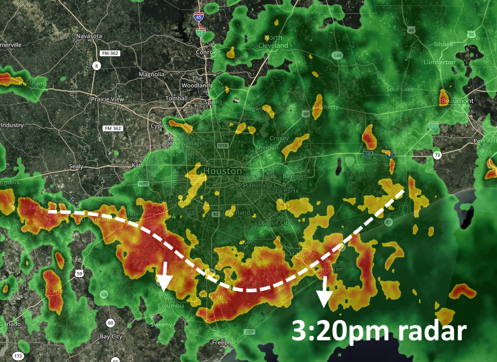
The atmosphere over Houston is pretty worked over. We should generally see diminishing storm coverage heading into sunset, and later this evening although we can’t rule out the re-development of some showers and thunderstorms. For the Houston metro area, we feel pretty good about not seeing another super-organized band of storms like we saw today—or anything approaching it. Areas far north of Houston, and we’re thinking more Walker and San Jacinto counties than Montgomery and Liberty counties, could see some more organized development later tonight.

Friday

Scattered showers will be possible Friday, but these generally should pop up, move through, and be done. They could exacerbate flooding in some areas, but their transience means they should not cause significant problems in and of themselves. Conditions continue to improve over the weekend.

Roads are a mess. Imelda messed with Texas. (Drive Texas)

Alas the damage is done. Anyone traveling today likely had a rough go of things. If you can stay home this evening, please do so. The roads should generally improve for tomorrow morning, but that assumes the forecast behaves tonight. If you experienced flood damage today, I am so sorry. Imelda has sucked and needs to move on.

Note: The site will go down for 10-15 minutes at about 6pm CT Thursday to ensure another outage like Wednesday night does not occur.

Very serious flooding situation evolving with Imelda’s remains

Simply put, all heck is breaking loose across the city as a slow-moving band of heavy rainfall slogs through Houston today. Unfortunately, while we knew heavy rainfall was likely in parts of the city today, we did not anticipate an event as significant in scope as this for Thursday. So far we have seen rainfall rates of 4 and 5 inches per hour in parts of the metro area, and it has caused widespread problems for much of Houston. Here’s three separate systems as of noon CT that bear watching.

Houston area radar at noon CT. (kktv.com/Space City Weather)

It is hard to have too much confidence moving forward, but very generally we can expect these storms to sag slowly to the south during the rest of the afternoon. We think rainfall rates have probably peaked as cloud tops associated with the system have started to warm a little bit, indicating less potential to produce the very heaviest rainfall rate. But in a slow-moving storm, 3 inches per hour can flood is more than enough to very quickly cause flooding.

The key message right now is that if you are in a dry location and it is raining heavily at your outside, you should not leave. If you have to drive through heavy rains, or heavily hit areas to get to your destination, stay where you are. Above all, do not drive into high water. A lot of people die that way. This storm will pass. We still have a general expectation that the overall system will weaken during the afternoon hours, and begin to dissipate after sunset.

Extremely heavy rainfall north and east of Houston sagging toward the city

We’re continuing to track a very intense band of rainfall just north and east of Houston, which has been producing rainfall rates of 2 to 4 inches per hour. The National Weather Service has declared a Flash Flood Emergency until 11:15 am for Southeast Montgomery County, Northeast Harris County, and Liberty County. This is enough to quickly flood streets and back water up into yards (and over a long enough period of time, homes). This band is now slowly sagging into the Houston metro area, as seen on the radar image below.

Intense rainfall band sagging southwest toward Houston at 9am CT Thursday. (kktv.com/Space City Weather)

We do not have a ton of confidence in the forecast other than this band should progress through most if not all of Harris County today, potentially bringing 2 to 8 inches of rainfall later this morning and afternoon. We do not know if it will strengthen further (unlikely), remain the same, or (hopefully) weaken as it progresses throughout the day. Needless to say it has the potential to disrupt any activities today, and we are likely to see flash flooding in the metro area as it moves through.

Meanwhile, the greater Beaumont region continues to experience a massive flooding situation as overnight rains devastated the area, and to some extent, are continuing this morning. The city has conducted hundreds of high-water rescues.


Beaumont pummeled overnight, one more day of Imelda for Houston

Good morning. Before jumping in to today’s post, I wanted to apologize for site outage problems during the overnight hours. This is very unfortunate timing and we will correct the problem going forward.

On Wednesday night, as anticipated, much of the Houston region passed a relatively quiet night. However, the same cannot unfortunately be said for regions to the east and northeast of Harris County. An extreme rainfall event has unfolded over Jefferson and Orange counties. This morning, the National Weather Service took the rare step of issuing a “Flash Flood Emergency” for the region, warning residents that, “This is an extremely dangerous and life-threatening situation. Do not attempt to travel unless you are fleeing an area subject to flooding or under an evacuation order.”

Area of flash flood emergency on Thursday morning. (National Weather Service)

This is really a terrible situation for Beaumont, Winnie, and surrounding areas. There are major issues on Interstate 10 through the area. Some areas have seen 10 to 15 inches of rainfall during the overnight hours, and a thick band of rainfall due to Imelda continues to saturate the area. It is showing no signs of movement for the next couple of hours.

Imelda’s rains have been worst to the east of Houston. (TWDB)

With respect to Houston, we have some concerns later today. A related band of storms near Conroe and Cleveland will likely eventually sag southward today. Accordingly, parts of Montgomery County will likely see 2 to 8 inches of rainfall today, and some northern and central parts of Harris County may see 2 to 6 inches of additional rainfall. These areas of the Houston region have, until now, been somewhat unaffected by Imelda’s heaviest rains so they can probably handle most of this rain. That doesn’t mean there won’t be any street flooding, however.

Houston radar at 5:40am CT Thursday. (kktv.com/Space City Weather)

We probably will see some additional storm development later today, but most of the activity should wind down this evening as the sun sets. By Friday morning we should return to more normal, business-as-usual pop-up thunderstorms. So we’ve all got to get through one more day of Imeda-misery. We will update accordingly.