A little more heat, a little rain, and an eye on the tropics

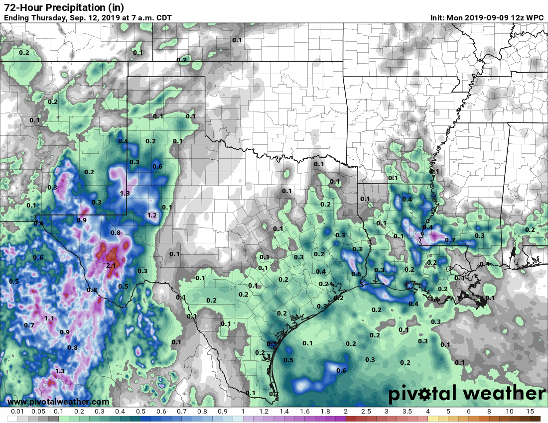
Scattered rain chances will continue through the middle of the week before sunnier skies return for the first half of the weekend. There still are no real signs of a cold front, alas, but we will need to keep an eye on the tropics over the next couple of weeks—which we’ll discuss below.

Tuesday

Similar to conditions on Monday, we’re going to see some scattered showers develop later today as Gulf of Mexico moisture streams inland. But as there is no real trigger for this atmospheric moisture to precipitate out of the sky, rain chances for most of the region will only be about 30 percent. Skies will be partly sunny, and whether high temperatures climb into the mid- or upper-90s will depend upon the extent of cloud cover and rainfall near you this afternoon. But we can safely say it will be hot.

Most of Houston should see some at least some light rain over the next three days. (Pivotal Weather)

Wednesday

Another day similar to Tuesday, albeit with higher atmospheric moisture levels. This should nudge rainfall chances up into the 50 percent range, and thunderstorms could briefly be fairly intense. Highs will likely be in the mid-90s.

Thursday and Friday

High pressure will begin to build over the region, helping to reduce rain chances down to around 20 percent each day. These should be mostly sunny days with highs in the mid-90s.

See full post

Extreme heat, dry weather may finally be breaking

It had not rained in September in Houston—at all—until a few areas saw some showers and thunderstorms this morning. Places like Oak Forest picked up about one quarter of an inch. This is indicative of an area of low pressure in the mid-levels of the atmosphere that will bump up rain chances over the next few days. Not everyone will get rain, but certainly this is the region’s best chance in more than 10 days.

Monday

It’s difficult to say what conditions will be like today. Some of the forecast models are pretty aggressive with rainfall later today, especially east of Interstate 45. Others show almost no development. Helpful, isn’t it? I’m going to side with the more bullish models and say the region has a healthy 40 to 50 percent chance of rain, especially during the afternoon hours. Some clouds should help cap high temperatures today in the mid-90s.

NOAA rain accumulation forecast for now through Wednesday. (Pivotal Weather)

Tuesday and Wednesday

Whatever happens today should provide some better guidance for what occurs on Tuesday and Wednesday, but right now I’d peg both days as having about a 40 percent chance of rain, with high temperatures in the low- to mid-90s.

See full post

September sizzle slogs along

Autumn is really just a state of mind. In Houston it has to be because you certainly would never know it was just about autumn by stepping outside. The high temperature on Thursday was 99 degrees at IAH Airport. Hobby managed to hit 96 degrees. This heat will continue.

Today and weekend

Expect mostly a rinse (without the water) and repeat weekend of weather here in southeast Texas. We will have sunshine and heat. High temperatures should flirt with 100 degrees each day for Houston and points north and west. Coastal locations should top off in the mid-90s. Morning lows should be in the mid- to upper-70s. It may be a degree or two less hot on Sunday.

It should be around or above 100° all across eastern Texas and Louisiana today. (Pivotal Weather)

As Eric noted yesterday, we will definitely have a good shot at tying or breaking some long standing record high temperatures today and tomorrow. Sunday will still be possible but probably a bit less likely. The records:

Friday: 99° (1909)
Saturday: 98° (1963)
Sunday: 100° (1907)

Stay cool and do your best to conserve energy, particularly today.

Early next week

The dome of high pressure responsible for our surge of September heat is going to migrate off to the east next week. It won’t be far enough away to allow any kind of meaningful cool air to drop through the Plains, but it should be enough to at least allow sea breeze showers each day off the Gulf. This would be of the 20 to 30 percent chance variety. I would expect mid-90s each day, along with a bit more more humidity.

See full post

Houston is about to break century-old heat records

Houston’s torrid late-summer weather will unfortunately continue, as expected, for the rest of the week. On Wednesday, the high temperature reached 99 degrees, and that’s pretty much the floor for what we can expect from maximum temperatures the rest of this week. By Friday, we’re likely to break a 110-year-old high temperature record.

Thursday

We will not touch the record high for Houston today, which is 108 degrees. If you lived in Houston, in 2000, you may remember the extraordinary heat wave of early September that year—this was the tail end of that period. Rather, Houston’s highs will “only” get up to around 100 degrees on Thursday as high pressure dominates the region. Rain chances are non-existent. Humidity will be a smidge below typical summer levels, which is about the only good thing that can be said about this heat.

The heat is on, y’all. (Pivotal Weather)

Friday

The high record for Friday is 99 degrees, set way back in 1909. We are very, very likely to beat that as Friday’s highs should get into the low 100s for most of the city. You’ll note new banners from Reliant on today’s post—it’s because the late summer heat is putting a strain on the state’s electricity grid. Please conserve energy if possible during the hottest part of the day.

See full post