A cool front slid into Houston during the overnight hours, setting the stage for two gorgeous days before we experience some potentially stormy weather heading into the weekend. But don’t worry, the weekend itself looks spectacular for mid-January.
Tuesday
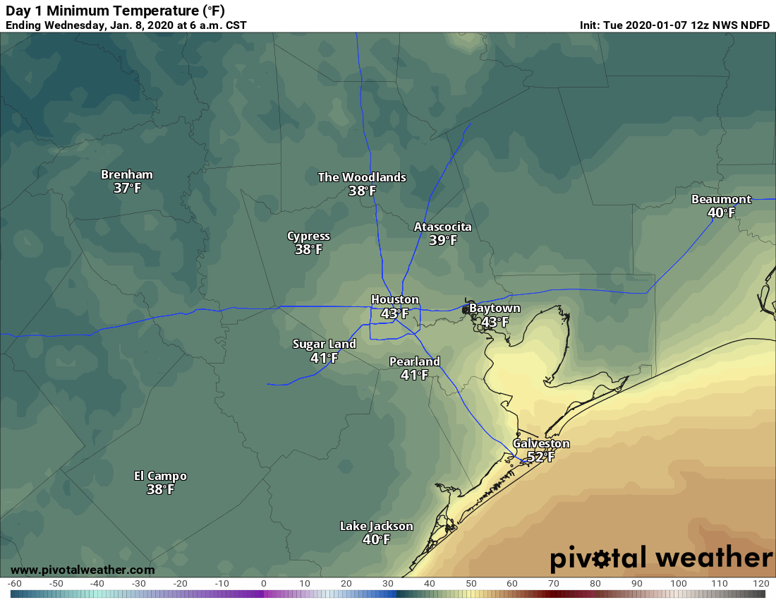
The region will experience sunny skies today, with highs in the mid-60s. Winds should be reasonably light, out of the north at 5 to 10 mph. With clear skies and light winds, Tuesday night will offer the opportunity for ideal cooling, allowing temperatures to drop into the 30s north and west of Houston.
Temperatures will be quite chilly on Tuesday night. (Pivotal Weather)
Wednesday
This will be another fine day, although sometime during the morning or early afternoon winds will shift to come from the southeast. This should allow highs to nudge a couple of degrees warmer during the day, and keep overnight lows to around 60 degrees in the city itself.
Thursday and Friday
The moisture return will set the stage for storms later on Friday, likely during the evening or overnight hours. Before this, we can expect warm and fairly humid weather—with highs in the upper 70s to possibly 80 degrees, and warm nights in the 60s. Skies will be mostly cloudy, with a 30 to 40 percent chance of light to moderate rain.
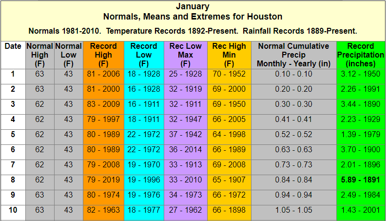
Houston just experienced an absolutely stunning weekend, with highs climbing into the 70s on Sunday. As a result, several people have asked whether winter is now over. It is decidedly not, but we are having quite mild conditions during what is normally the “dead” of winter. Historically, the first 10 days of January represent the coldest time of the year, when the average low in Houston falls to 43 degrees, and the average high is 62 degrees. With that said, Houston can have pretty strong cold outbreaks through the middle of March, so “winter” will likely last for about two more months. Inland parts of the region, at least, have a pretty good shot at reaching the 30s next weekend.
Welcome to the coldest time of year, Houston. (National Weather Service)
Also, please note that today begins the first of our daily looks at weather for the upcoming Houston Marathon, which takes place on Sunday, January 19. Those updates will occur at the end of each post.
Monday
Today will be another warm and pleasant one across Houston, with highs likely topping out in the mid-70s under mostly sunny skies. Winds will be light, out of the southwest. We would definitely be on a major upward trend in terms of temperatures but for a moderate cold front tonight. Expect it to pass through the region around midnight, give or take an hour or two, without the prospect of any rain. Lows should get down to around 50 degrees early Tuesday.
Tuesday
If you’re wondering what winter typically feels like in Houston, in January, today’s the day. Look for highs in the low- to mid-60s with lows in the low- to mid-40s. Skies will be sunny.
Wednesday
Winds will return from offshore on Wednesday, and you may notice them begin to kick up during the afternoon hours. They could gust up to about 20mph, or a bit higher along the coast. Otherwise, highs will reach into the upper 60s, with sunshine in the morning, and likely increasing clouds during the afternoon and evening as moisture levels rise in the atmosphere.
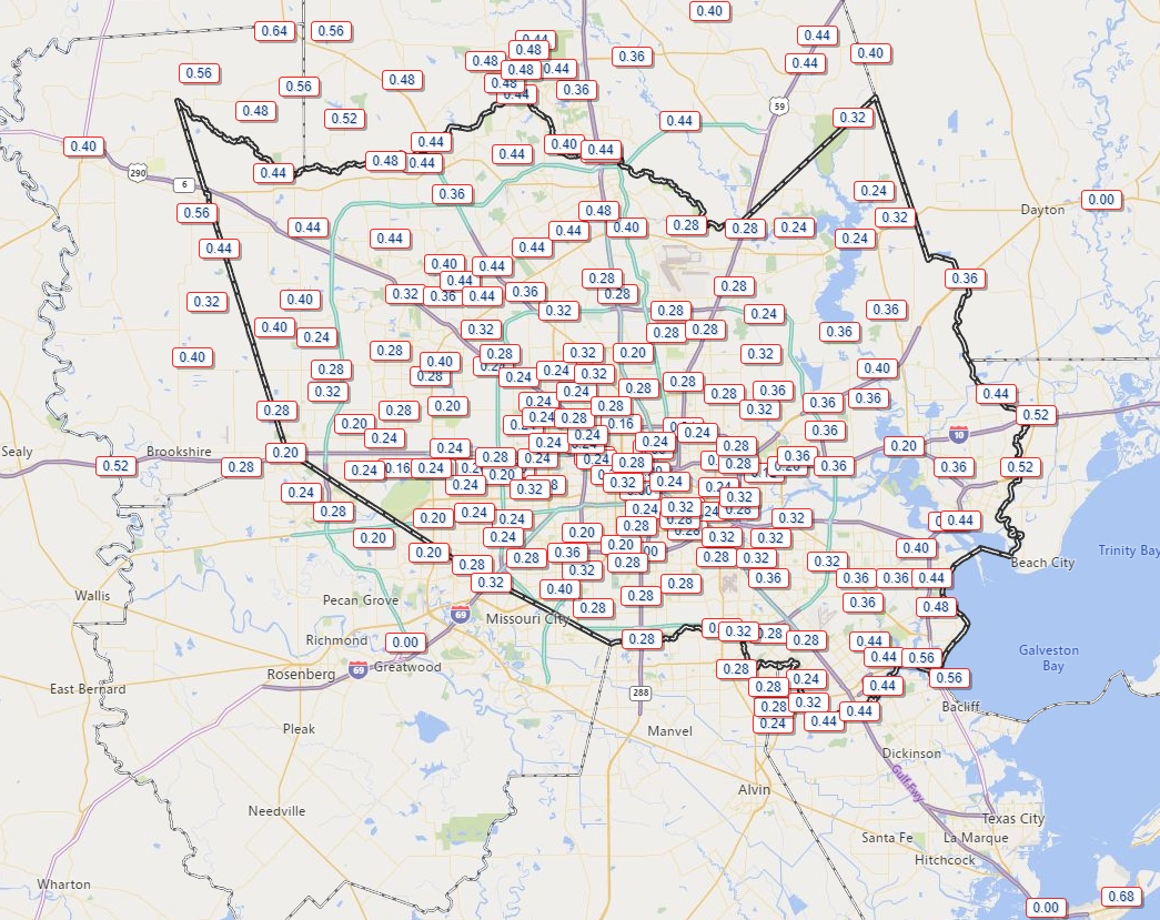
Happy New Year to you! So it rained a bit yesterday. Most areas received a quarter-inch to half-inch of rain, and just a few higher amounts to the north and along the coast.
Rain amounts were generally in the quarter to half inch range yesterday, with some higher amounts north and west and also along the coast. (Harris County Flood Control)
We could certainly use some rain, and while the totals were fairly low overall, the pace of mostly steady light to moderate rain and just some occasional embedded downpours was helpful. We will now return to pleasant weather for the weekend.
Today & tonight
First, some fog. Use caution this morning, as fog has developed in parts of the area, restricting visibility. Look for any fog to lift by late morning, leaving us with partly to mostly sunny conditions. We should top off in the mid-60s or a touch warmer today. It will be a chilly night tonight with mainly clear conditions. We should drop into the low- to mid-40s in the city and around 40° in outlying areas.
Weekend
Saturday should be gorgeous. Expect sunshine and mid-60s once more. We will cool back into the 40s or low-50s Saturday night under continued clear skies. Sunday looks mainly sunny again. It will be warmer, with highs approaching or exceeding 70° in most spots. Winds should be light Sunday, but if you’ll be out on the bay Friday night or Saturday morning, it will be breezy with offshore wind gusts approaching 25 mph or so.
Monday
Onshore flow will be with us Monday, helping temperatures to warm from the 50s into the 70s in most places. We will see a few more clouds on Monday as well, so call it partly sunny.
Tuesday and beyond
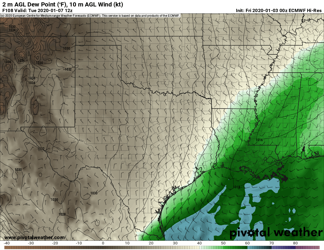
Our next cold front is penciled in for Tuesday morning. As of right now, the front does not appear to have too much going for it as it passes through Southeast Texas, so while a brief passing shower will be possible, I think most places will stay dry.
Tuesday morning’s forecast from the European model shows the next cold front just east of Houston, with higher humidity (in green/blue colors) swiped off to our east. (Pivotal Weather)
Behind the front, it will turn breezy and cooler. Expect morning lows Tuesday around 50° or so, depending on the exact timing of the front. We will clear out quickly behind it, and warm into the low-60s. Temperatures will stay chilly behind the front for Wednesday, with morning lows in the 40s, if not some 30s in spots. We should warm back up through the 60s, perhaps into the 70s again toward next weekend, as onshore flow takes hold.
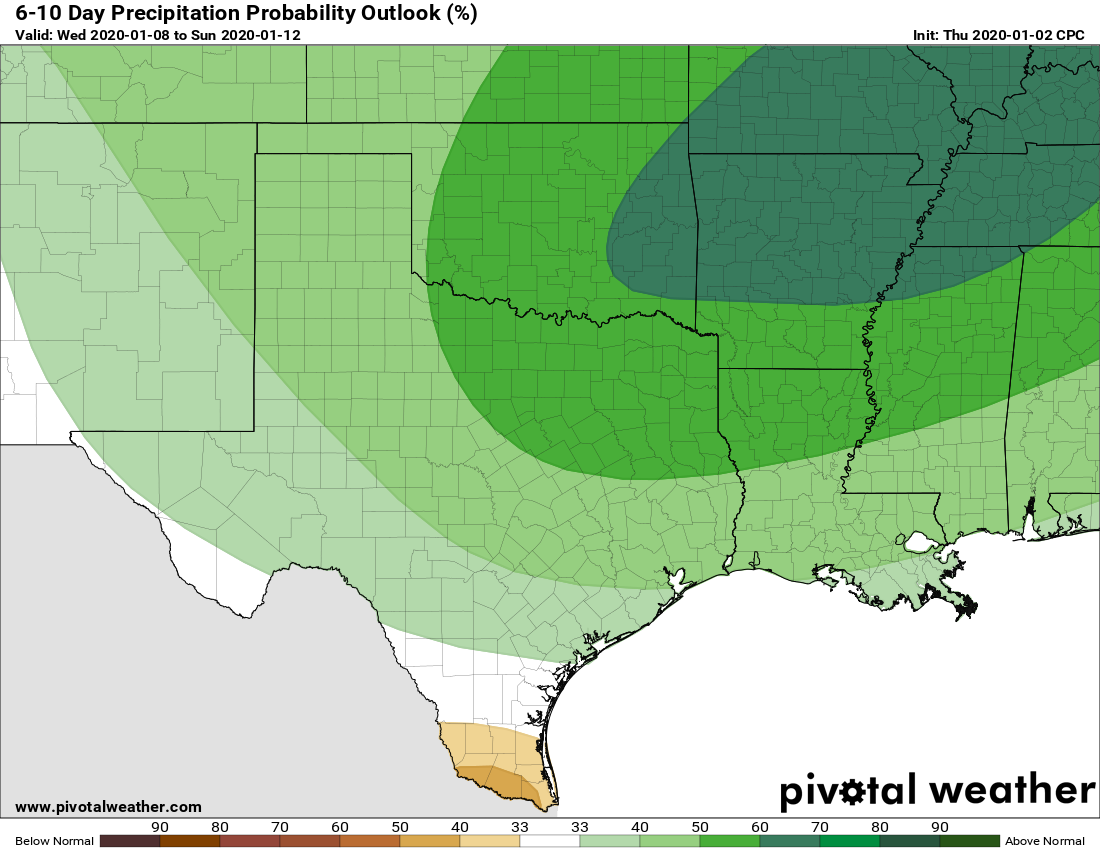
The details beyond next Wednesday are fuzzy, but I would expect us to be discussing some more rain chances, fog, and the potential for another cold front by next weekend or so. There are some questions surrounding that, but forecasts for the day 6 through 10 timeframe suggest above normal rainfall.
The NWS Climate Prediction Center outlook for days 6 through 10 calls for an increasing probability of above normal rainfall. (Pivotal Weather)
We will dive more into that topic in Monday’s conversation. More for you then. Enjoy the beautiful weekend!
Good morning, and welcome to 2020! Light rain has fallen across the region overnight, and with lows only in the mid-50s to lower-60s across the region this morning fog has developed near and along the coast. This should burn off later this morning. Overall, our forecast remains the same, with additional light-to-moderate rain possible today, and then clearing skies for a beautiful weekend.
Thursday
Rains have temporarily stalled this morning, but we expect an additional round of showers this afternoon into the early evening as an upper-level system moves across the area. Accumulations for today will likely be below one-half inch of rain. Rain or not, this will be a gray day, with highs in the mid-60s. Rains should end for most of us Thursday night.
Friday
Lows Friday morning will only bottom out in the mid-50s, and with light winds this should again provide favorable conditions for the development of fog. This soupy weather should end by around midday as a cool front pushes through Houston from west-to-east, bringing somewhat drier air and helping to clear out our skies. Highs Friday should be in the mid-60s, with overnight lows falling into the 40s.
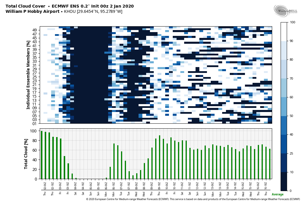
That’s a lot of sunshine from Friday through next Wednesday. (Weather Bell)
Saturday and Sunday
As mentioned, this weekend will be a winner. Whether your plans include tailgating for the Houston Texans game or yard work or whatever, we’re going to enjoy sunny skies with highs in the mid-60s on Saturday, and sunshine and highs of around 70 on Sunday. Depending on your distance from the coast, lows will either be in the 40s or 50s.
Next week
Just as things begin to warm up on Sunday another moderate cool front will push into the region, likely around Monday morning-ish. This should help keep high temperatures in the 60s through Wednesday of next week, with overnight lows generally in the 40s. Oh, and there will be plenty of sunshine. Our next best chance of rainfall after today probably will not come until next Thursday or Friday—so yeah prepare for some very fine weather indeed.