Good afternoon. Just wanted to jump in with an update on storms anticipated for tonight. We’re wary. We’re watching. But we’re not overly worried—and we don’t think you should be either.
This front and associated strong squall line have received a lot of media attention this week, and we’re not entirely sure why. It may be because there really has not been any significant weather to hit Houston for three months or so. But if anything, the model trend today is toward a slightly less severe threat for greater Houston. It’s definitely prudent to be weather-aware tonight. And I wouldn’t be out and about when the squall line hits. But we will face worse threats later this year so let’s temper expectations.
The primary threats tonight are damaging straight-line winds (we may see some gusts above 60mph), potentially a few tornadoes, and possibly some hail. Here’s the timing for the worst of the weather, which should last an hour or less for most locations.
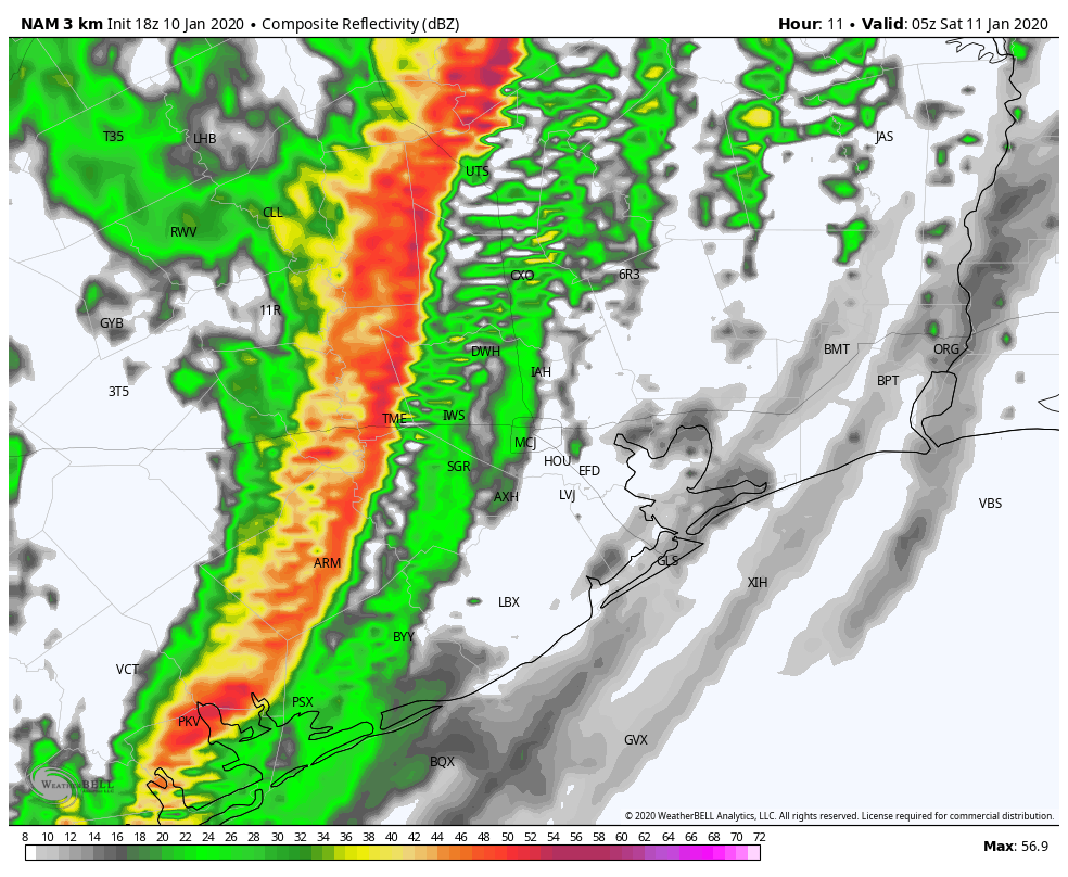
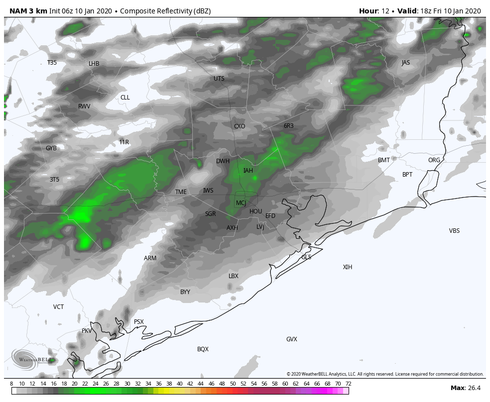
11 pm CT
NAM model forecast for radar reflectivity at 11pm. (Weather Bell)
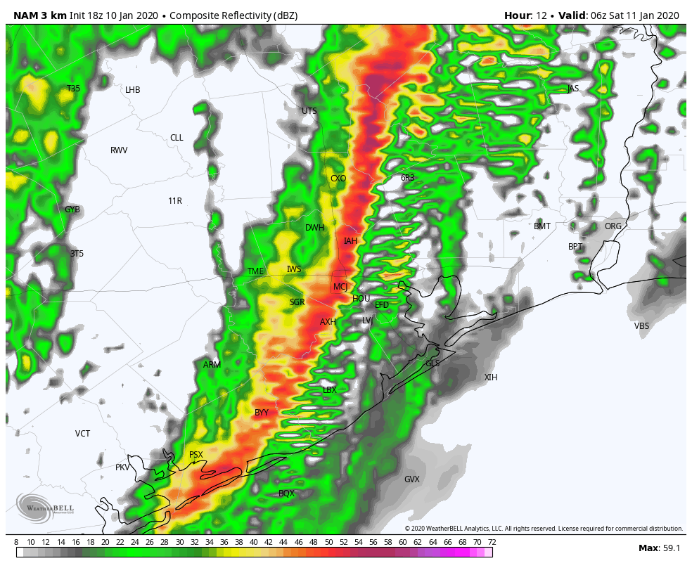
Midnight
NAM model forecast for radar reflectivity at midnight. (Weather Bell)
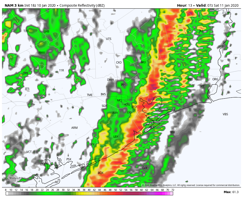
1 am CT
NAM model forecast for radar reflectivity at 1am. (Weather Bell)
Stay safe! Please know that if conditions come in worse than expected we will be here to update as needed. Other than that, do enjoy the beautiful weather this weekend after the front passes.
As we’ve been discussing this week, the Houston area will see showers and thunderstorms later today or tonight and severe weather will be a possibility. I’m going to walk you through the day and hopefully provide answers to most of your questions.
Overview
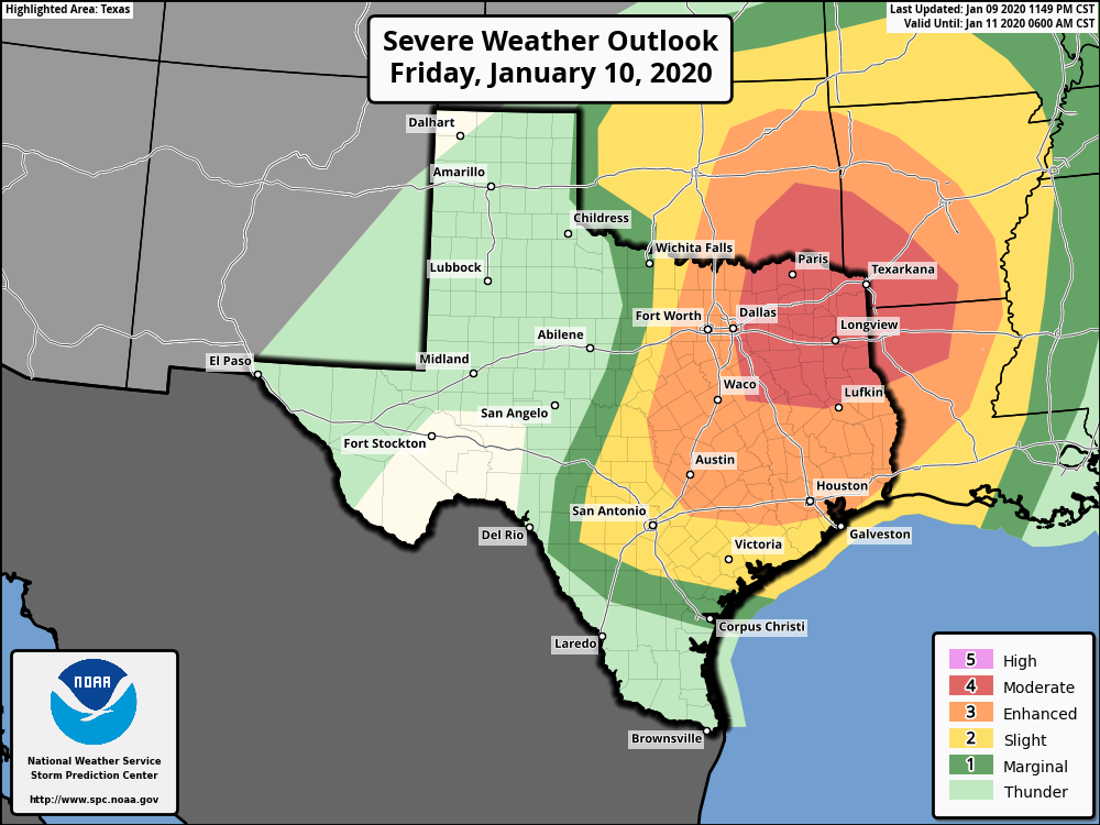
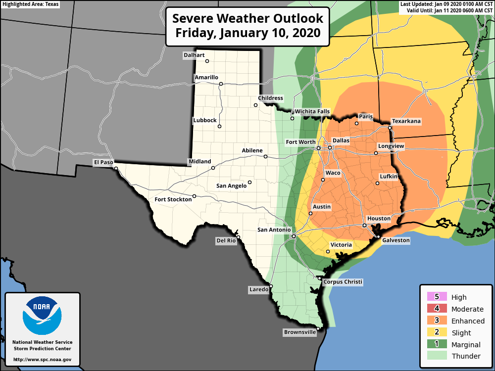
The Storm Prediction Center (SPC) is continuing to keep the majority of the Houston area in the enhanced risk for severe thunderstorms today.
The SPC has most of the Houston area in the enhanced risk (3/5) for severe weather for storms tonight. A slightly more significant risk exists well off to our north. (NOAA Storm Prediction Center)
Based on what we’ve seen in modeling, for the Houston area, this threat will primarily occur much later today, after 5 PM and more likely closer to Midnight. So if you don’t see any rain or hear any thunder through this evening, do not be shocked. There may be isolated severe storms in the evening hours before a squall line of widespread strong to severe storms moves through just before midnight.
One model’s interpretation of what the forecast radar could look like between Noon today and 6 AM Saturday. (Weather Bell)
The severe weather threat quickly ends from west to east after midnight. The weekend looks fine.
This morning
Look for clouds and maybe a few passing showers. No severe weather will occur this morning. Temperatures, which actually rose a couple degrees overnight will continue slowly warming through the 70s. It will begin to turn breezy again, and winds could pick up to 15 to 25 mph or even stronger, especially along the coast and bays.
This afternoon (Noon to 4 PM)
We should see clouds, wind, and showers at times continue. Temperatures will warm into the mid- to upper-70s. We do not believe that the Houston area will see much in the way of thunderstorms this afternoon. Any strong to severe storms through afternoon will more likely occur way off to our north and west, well out of the metro area and region (think: Hill Country or perhaps up toward Tyler).
This evening (4 PM to 9 PM)
This is the part of the forecast in which we have the lowest confidence. Our best guess right now is that most of us will only see a couple passing showers in this timeframe. However, there is some chance that a couple rogue thunderstorms may begin to develop. Should this occur, any of those storms could quickly turn severe with hail, damaging winds, or even a tornado. To be clear: We believe this will very much be the exception, not the rule in the evening hours. Still, if you’re out this evening, ensure you have a way to receive weather warnings, just in case things get a little more chaotic than we are expecting right now.
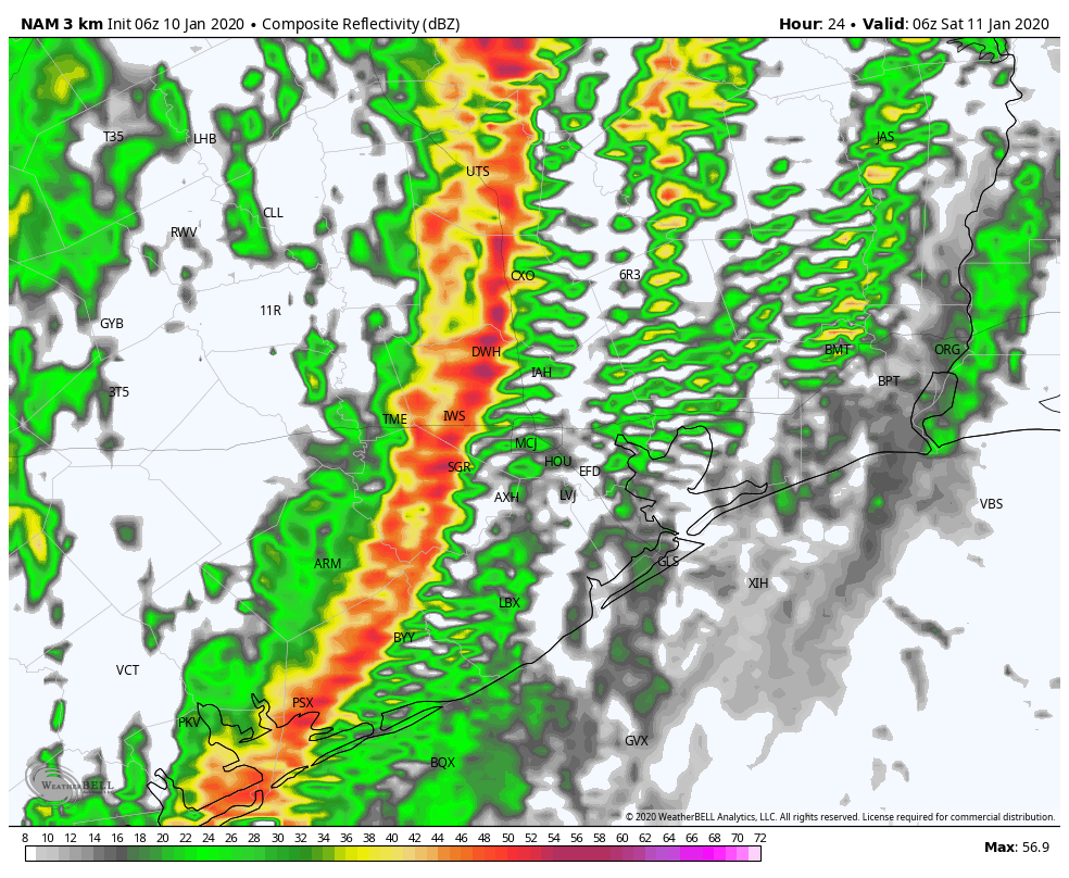
Tonight (9 PM to 3 AM)
This will be the main timeframe that we see impacts from this event. Severe storms in Hill Country and the I-35 corridor should have congealed into an organized squall line by later this evening. Ahead of the line, we should see more numerous showers and a few thunderstorms begin to develop here. Any of those storms could become strong to severe, but it seems as though the primary concern will come from the squall line itself, which is going to quickly sweep across the region toward midnight.
Snapshot of the NAM model’s forecast radar around midnight, which shows a well organized squall line. Typically, these types of systems have a higher risk of damaging winds than other modes of severe weather. (Weather Bell)
As of right now, we expect the line to hit College Station around 9 or 10 PM, Huntsville through Sealy by 10 or 11 PM, the majority of the Houston metro area between 10 PM and Midnight, Galveston through Lake Jackson between 11 PM and 1 AM, and Beaumont/Port Arthur between about 1 to 3 AM. All those times are approximate and give or take an hour or so.
We’ll say goodbye to sunshine for a couple of days, and our focus will now turn to the potential for severe weather on Friday night. A strong line of storms will sweep through Houston from west to east, likely from about 9pm to 3am. All of the usual threats will be there—large hail, damaging winds, and potentially tornadoes. Because of the storm’s progressive movement, we do not expect rain totals much above 0.5 to 1.5 for widespread areas, with higher isolated amounts. It may be severe, but it will be over quickly.
Thursday
Today will be mostly cloudy, with southerly winds continuing to pile moisture into the region. However, a fairly stiff capping inversion—this is situation where warmer temperatures higher up in the atmosphere prevent warm, moist air at the surface from rising—should preclude all but some scattered, light showers today. Highs will reach the upper 70s for most of the area, and temperatures Thursday night will not fall much below 70.
NOAA Storm outlook for Friday and Friday night.
Friday
Friday will start out a lot like Thursday, with an increasing chance of storms throughout the afternoon and evening hours. While you may see some showers during the daytime hours (which will be warm, with highs again likely in the upper 70s), the main event will be a line of storms moving through. NOAA’s Storm Prediction Center has expanded the area of “enhanced” weather somewhat southward and westward. This means it will be possible, but by no means certain that we will see strong wind gusts of 75+ mph, large hail and tornadoes. There will be heavy rainfall too, but it should move through quickly. The bottom line is that if you are out and about on Friday night, be very weather aware. (I’d definitely plan to be home before the storms hit). And if you’re at home, be prepared if a tornado warning is issued for your area.
It is quite cold across Houston this morning, with temperatures generally in the 30s in outlying areas, and low 40s in the central Houston area. After days and days of sunny weather our skies should turn cloudy later today, warmer, and then stormy on Friday, before pleasant weather returns again for the weekend.
Wednesday
Just a quick note: With clear skies on Tuesday and Wednesday mornings, please note that if you saw a white streak in the sky above Houston during the pre-dawn hours, it was this the of 60 Starlink satellites launched Monday night by a SpaceX Falcon 9 rocket. (More information on how to see them here). They will gradually become fainter as they raise their orbits over the next month.
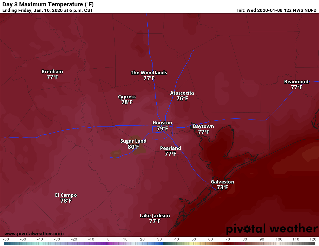
Friday may bring some of the first 80-degree readings of the year for parts of Houston. (Pivotal Weather)
Overall, today should be another nice one, with partly sunny skies and temperatures in the upper 60s. However, winds will become noticeable out of the south later this afternoon, gusting up to 20mph, bringing much more humid air into the region, and setting the stage for storms later this week. Lows Wednesday night will be considerably warmer, unlikely to fall below 60 degrees in Houston.
Thursday
A gray day. Expect highs to rise into the mid- to upper-70s despite the cloudy skies, More gusty winds from the south will continue to transport moisture inland, and we can’t rule out some scattered showers and thunderstorms during the afternoon and evening hours—but we don’t expect significant accumulations. Thursday night should be rather warm, likely in the upper 60s.