Storms possible later today, but the bigger threat lies north of Houston

Houston will see the threat of severe weather this afternoon and early evening as a storm system moves through the region, ahead of a cool front. After this we expect several days of dry, sunny weather to dominate the region. It will be warm, but not too warm for late spring, with some reasonably cool nights this weekend.

Wednesday

Temperatures this morning are in the mid-70s, with cloudy skies. Unlike Monday and Tuesday, however, we won’t experience much if any clearing skies later today. Instead, the region will see an increasing chance of storms. The bigger threat lies north of the metro area, over areas such as Lufkin and Waco, but almost the entire Houston region faces a “slight” chance of hail and damaging winds. The rain chances with this storm system are pretty meager for Houston, especially areas south of Interstate 10, as the capping inversion may prove unbreakable. That’s unfortunate, because there are a lot of dry areas such as Brazoria County that could use some precipitation and probably won’t get much, if any with this system.
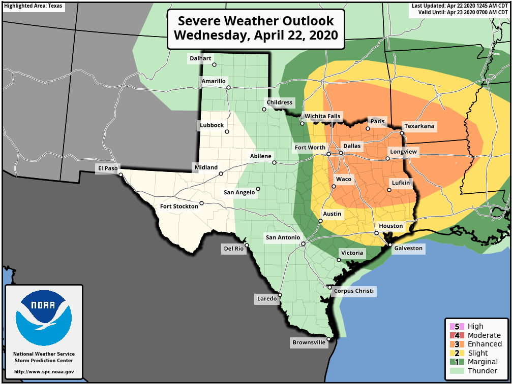
Storm outlook for Wednesday and Wednesday evening. (NOAA)

Thursday

A secondary, thin and broken line of showers may pass through the area early Thursday before sunrise along with the cool front itself. In its wake, we should see clearing skies and highs in the mid-80s on Thursday. Lows will drop into the mid-60s.

See full post

Lots of sunshine and some fairly dry air this week in Houston

The good news is that if you enjoyed Monday’s weather we have plenty more days like that this week—warm, but not too warm, with lots of sunshine. Wednesday will be the only real exception to that. Our weekend weather also looks pretty fine if you’re looking for sunshine and drier air.

Tuesday

Any patchy fog this morning should burn off quickly, and like on Monday we should see a transition to partly to mostly sunny skies this afternoon. However, with winds turning to come from the southeast later today we expect clouds to return pretty quickly this evening to make for mostly cloudy skies. Highs today should reach the low 80s for most people, with low temperatures Tuesday night falling to around 70 in the city—lower inland, and warmer along the coast.

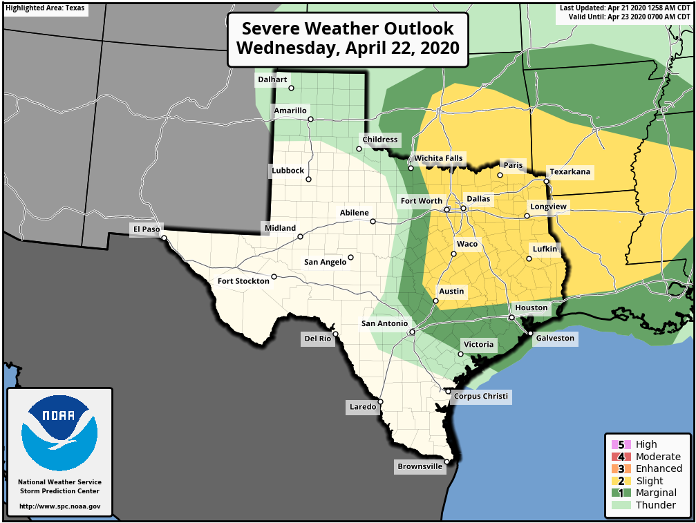
Severe weather outlook for Wednesday. (NOAA)

Wednesday

This is the one day this week the potential for some dynamic weather. An upper-level storm system will drop down toward Texas on Wednesday, but the effects look to be most pronounced for north and east Texas, with the Houston metro area on the southern periphery of the action. Models suggest that a mass of showers and thunderstorms will move through Houston during the afternoon or early evening hours on Wednesday, with the better organization north of Interstate 10. Areas such as Montgomery County and points north may see 0.5 to 1.5 inches of rain, while much of the rest of the region sees a few tenths of an inch or less. Highs Wednesday will be around 80 degrees with mostly cloudy skies.

See full post

A week of mostly sunny days, except for Wednesday

Sunday’s storms were again hit or miss. Some parts of Montgomery County picked up more than 2 inches of rainfall and saw plenty of lightning, while the southern half of Harris County saw very little rainfall. Looking ahead, we will see a pair of sedate, mostly sunny days before another chance of storms later on Wednesday. Our early look at next weekend’s forecast is mostly optimistic.

Monday

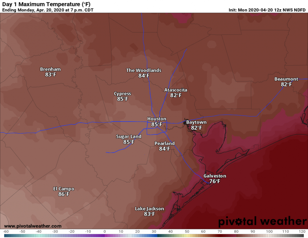
Skies should transition from cloudy, to partly sunny, to mostly sunny by early afternoon. This should help high temperatures push into the mid-80s this afternoon, with light winds from the north switching to come from the southeast. All in all this will be a pretty typical day for late April in Houston. Some clouds return tonight, as lows fall into the 60s for most of the area except for the coast.

Monday’s high temperatures. (Pivotal Weather)

Tuesday

This will be another day like Monday, in that early morning clouds should transition to sunnier skies later in the day. Highs will again settle somewhere in the mid-80s, although the southeasterly flow of winds should become a little more pronounced, making for a bit warmer night as clouds return. The southern half of Houston probably won’t fall below 70 degrees overnight.

See full post

Strong storms possible in Houston today followed by a cool front tonight

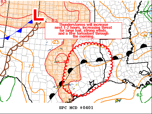
Good morning, everyone. We interrupt your Sunday with a short post on the threat posed by severe weather today. Strong thunderstorms are possible in Houston this morning and during the early afternoon hours ahead of a cold front.

Thunderstorms will develop over Houston later this morning. (NOAA)

Several favorable dynamics in the atmosphere—including an eroding capping inversion—should combine to allow organized storms to form along a eastward-moving system that will push through Houston between around 9am and 3pm today. Large hail, damaging winds, and a few tornadoes are possible. It is likely that a tornado “watch” will be issued for the area.

Note that this is not a classic line of storms, and some locations could see more than one round of severe weather. Rainfall accumulations will vary widely, but we do not expect widespread flooding issues. Not everyone will see severe weather, and chances are probably a little bit better north of Interstate 10, but please do be weather aware today.

In the wake of the front tonight, expect clearing skies and lows in the 60s. Monday and Tuesday should be pleasant, sunny days with a chance of storms returning Wednesday.