Since Wednesday’s cold front, Houston has had 50 consecutive hours of dewpoints below 60°, which continue as of 7 AM Friday. Recall, dewpoint is a much better gauge of “comfort” in summer than relative humidity, and for Houston anything below 65° generally feels really nice this time of year. Anything in the 50s is very comfortable. To put in context how rare an event this is in Houston in summer. We have only done 40 consecutive hours of dewpoints in the 50s in June, July, or August two other times since Bush Airport was established as the official reporting station for Houston in 1969:
June 8-9, 1996 (43 consecutive hours)
June 24-28, 1974 (110 (!) consecutive hours)
It appears that this one will place firmly 2nd on the list. This air mass would be a first ballot inductee to the Hall of Fame of Comfort for Houston summers. And it continues.
We do have a couple things to monitor. This dry weather is going to have an impact on soil moisture in much of Texas. We’ll discuss that more in-depth next week. In addition to that, this dry, offshore breeze is certainly aggravating for allergy sufferers (raises hand). But other than that, we have little to talk about.
So in lieu of much text today, our forecast will be shared primarily in gif form.
Today & weekend
It will be tough to let go of the current weather pattern. Thankfully, this weekend won’t be too bad!
It’s my birthday weekend, and the humidity will remain low. This is how I’m feeling.
Expect highs in the 90s and lows in the 60s or low 70s this weekend, with continued low humidity for June. Sunshine and nil rain chances.
Full sun, a week out from the solstice? Load up on sunscreen this weekend.
Next week
Onshore winds resume Monday, and that means our friendly neighborhood Houston humidity will be on the rise.
Humidity begins to return next week…
But it won’t be that bad of a week.
“Won’t be so bad” is a relative phrase.
Alright, yeah, it will end up being a pretty hot week. Look for mid-90s at least, with lows in the 70s.
By the middle of next week, it’s likely to feel like summer in all its glory here.
The next chance of any meaningful rain at all, outside of a localized downpour? Maybe next weekend?
The 90s and “No Rain:” A Blind Melon forecast.
We’ll check back in with you on Monday with more. Enjoy the weekend!
Conditions this morning are spectacular across Houston, with temperatures in the 60s for most locations. Cleveland and Conroe hit the upper 50s! Dewpoints at many locations on Wednesday dipped below 50 degrees, a real rarity for June. Happily, this pattern should be with us through most of the weekend before humidity levels really start to stack up again beginning next week. After that, plenty of heat is on the way as well, with sunny skies.
Thursday
Expect sunny conditions with highs in the low 90s. A light wind from the northeast at 5 to 10 mph will keep the air dry, and help nighttime temperatures cool again into the upper 60s for most areas.
Friday and Saturday
These days will be similar to Thursday, with mostly sunny skies, and highs in the low 90s. Winds will remain from the northeast. Lows should reach the 60s for inland areas.
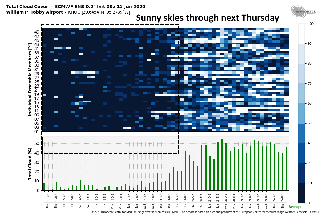
Expect sunny skies to prevail for at least the next seven days. (Weather Bell)
Sunday
The second half of the weekend should be slightly warmer, with a little more humidity. Expect sunny skies with highs in the mid-90s. Nighttime temperatures will creep back above 70 degrees for most locations.
Monday and beyond
Winds will return to come from offshore by Monday, and you know what that means. Temperatures will rise back into at least the mid-90s with heat indices likely in the 100s due to the humidity. We’ll be back to very hot, summer-like conditions in Houston. High pressure should dampen rain chances—had to use that word because it’s the only wet stuff in the forecast for next week—until at least Friday or Saturday. We should see mostly sunny skies until then, as well.
Nearly three months have passed since we first addressed COVID-19 and the then-unknown effect of weather on its spread in warmer climates. Since that time we have learned some things, and have three months of data to draw upon in Texas. From this we can conclude that although weather may have some modest effect, it is not likely to have a significant dampening effect on the transmission of the disease.
COVID-19 and Texas
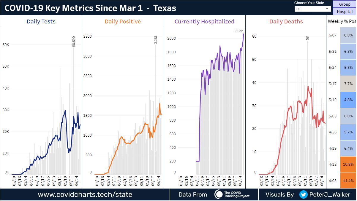
We’ll start this post by looking at the spread of COVID-19 in Texas. I encourage you to visit this site, put together by Peter James Walker, which provides amazing visualizations of coronavirus data (from the Texas Department of State Health Services) with regard to testing, positive cases, deaths, and hospitalizations. This allows us to understand trends in the data.
COVID-19 data in Texas. (covidcharts.tech)
Here we can see that cases are more or less increasing in line with more testing across the state. However, after initially dropping, the share of positive tests seems to be increasing, up to 7 percent from 5 percent about one month ago. So far, at least, deaths have not caught up to cases. This may be due to better care, or some other factors. It’s just hard to know.
What concerns us is that hospitalizations have reached a record high in Texas for COVID-19. You may have questions about the test data, or false positives, but hospitalizations for COVID-19 are measurement that is difficult to fudge. The trend is upward, and real. We are still a ways away from reaching hospital and ICU capacity in Houston or across the state, but the concern is where does the trend go from here? I don’t think anyone can say.
Weather and COVID-19
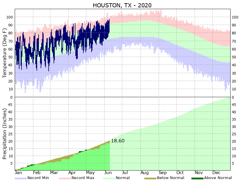
What we can say is that this spike in hospitalizations (and thus, severe cases) due to the virus is occurring at the very moment when summer heat is beginning to descend on Texas. The state’s average temperature in June reaches 90 degrees. Much of the state is humid most of the time in summer. And still, the disease is spreading. In fact, based upon the hospitalization data, it seems clear that COVID-19 is more widespread now in Texas than at any time before. The disease is spiking even harder in other, similarly warm states, such as Arizona.
Houston’s temperatures have gone up, as cases have gone up. (National Weather Service)
This supports the emerging science viewpoint on weather and COVID 19, that summer heat will not be much of a factor in slowing its initial spread through the human population.
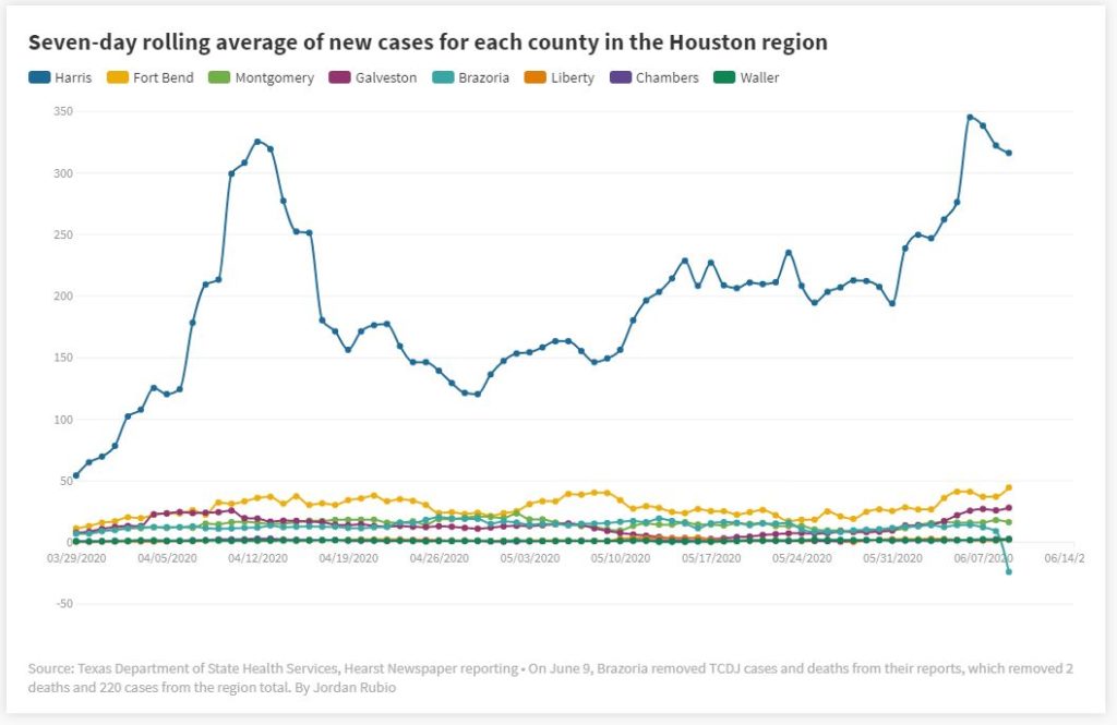
Seven-day average of COVID-19 case count in Houston region. (Houston Chronicle/Flourish)
The public health messaging from the World Health Organization and the U.S. government amidst this pandemic has not been consistent or particularly good. However, the data are telling us that COVID-19 is still spreading in Texas despite the heat. It may become even more widespread this summer as we (understandably) seek to return to a business-as-normal posture. What seems prudent is the continued wearing of masks in locations where social distancing is not possible. When you wear a mask it may be uncomfortable, you may think it makes you look funny. But you’re also telling the person next to you that you value them, and want to do your part to prevent spreading COVID-19 too far.
Sponsor Note from Reliant
To support our neighbors across Texas, Reliant has committed $765,000, including $440,000 to the Greater Houston area, for local community relief funds, initiatives to protect frontline workers and those adversely impacted by COVID-19, and treatment/prevention solutions. The donations are part of our community program, Reliant Gives, to provide support across the state of Texas and our parent company, NRG Energy, Inc.’s $2 million donation to pandemic relief efforts. Learn more about our commitment and customer support resources here. Now more than ever, we’re working to light the way and keep Texans powered and connected to one another.
Winds have shifted to come from the north this morning, and dewpoints are falling in the wake of a cold front passage. On Tuesday morning at 6am CT, the dewpoint temperature at Bush Intercontinental Airport was 75 degrees; this morning at the same time it is 55 degrees. The lower the dewpoint, the drier the air feels, and it makes quite a difference. There is a chance dewpoints in parts of the city could fall below 50 degrees later today and this evening.
To get a sense of how rare such a front is during the summer months of June, July, and August, consider historical dewpoints in June. Matt compiled how many times the dewpoint has fallen below 50 degrees at Bush Intercontinental Airport, since 1980. Here’s the list of days, with the number of hours below 50 degrees:
Jun 1, 1984 (5 hrs)
Jun 11, 1988 (4 hrs)
Jul 13, 1990 (3 hrs)
Jun 9, 1996 (1 hr)
Jun 1, 2012 (4 hrs)
So if you’ve been wondering why meteorologists are making a big deal out of a “front” that only knocks high temperatures down into the low- to mid-90s, the answer is very dry air. It will have a meaningful effect on both humidity and temperatures this evening when you walk outside.
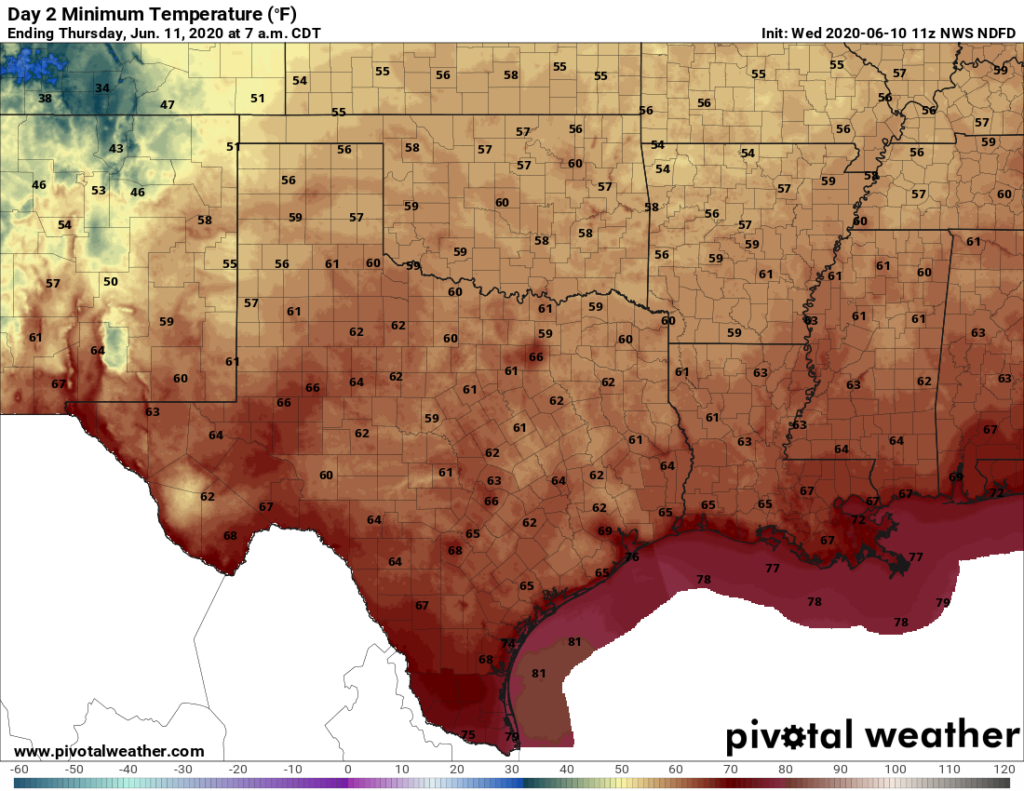
Low temperature forecast for Thursday morning. (Pivotal Weather)
Wednesday
Nearly all of Harris County missed out on rain showers as the front moved through this morning, as they ended up developing east and south of the region. High temperatures today will go up into the low-90s with sunny skies. Winds will blow from the north at 10 mph. Lows tonight will drop into the 60s for most of the area—heavenly for mid-June to be sure—but we’ll probably remain above the record low for June 11 of 61 degrees, set in 1976.