So it’s been hot in Houston this month, especially the nights. The low temperature this morning at Houston Hobby Airport is likely to fall no lower than 81 degrees. This would make for the tenth day so far in July that the temperature has failed to fall below 80 degrees at that location. This extends a new record for mornings with 80- degree mornings, or above, for the month of July. The previous record for the most of these days at Hobby was eight, in 2016, according the National Weather Service. Also, July is not quite half over yet.
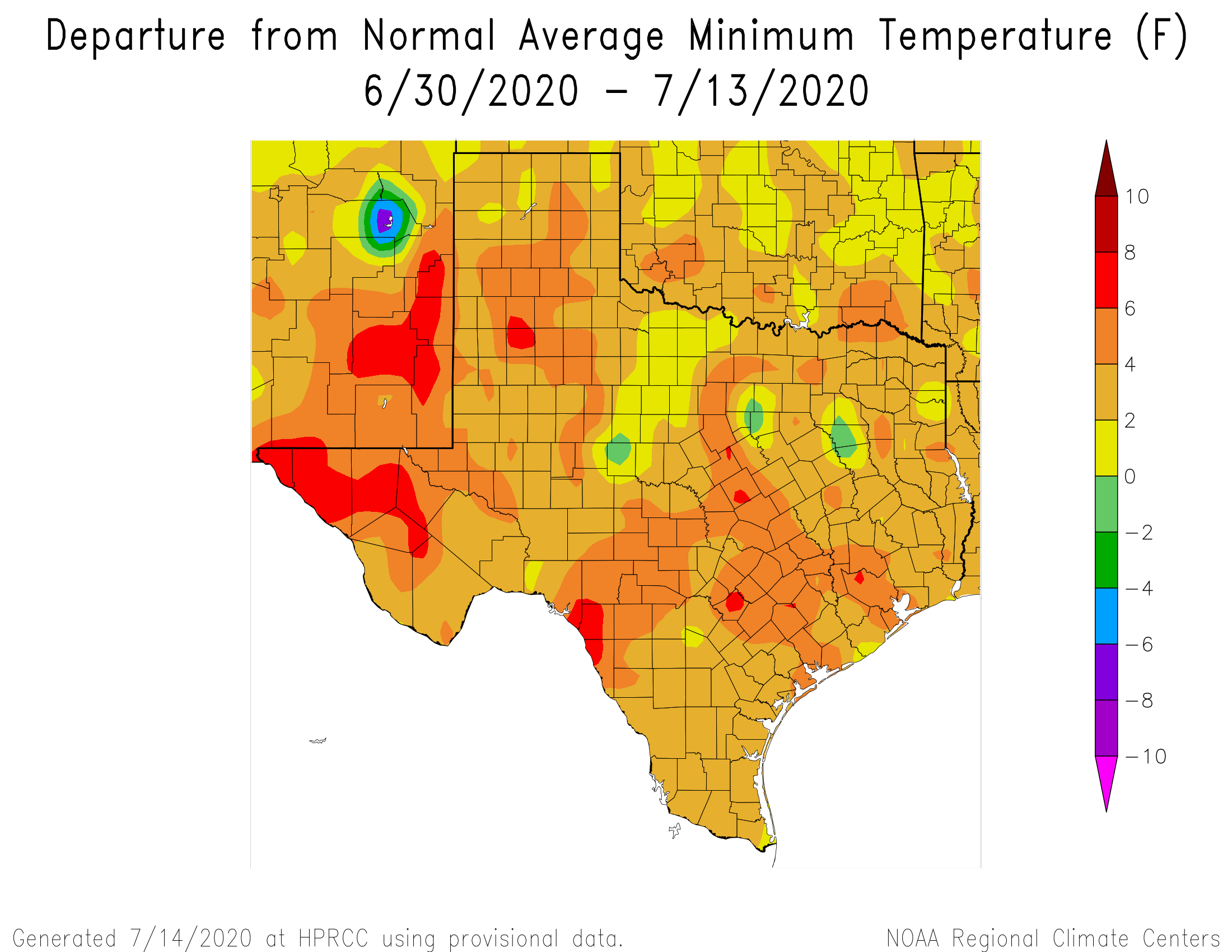
Low temperatures in the Houston region have been 4 to 6 degrees warmer than normal in July. (Unl.edu)
Fortunately, some scant relief is coming as the high pressure that has dominated our weather this month begins to weaken and slide east. This will slowly bring down temperatures and, eventually, introduce some moderate rain chances to the area. We think the second half of this month will be much closer to “normal” for a Houston summer than the extremely warm nights and days we’ve experienced over the last two weeks.
Wednesday
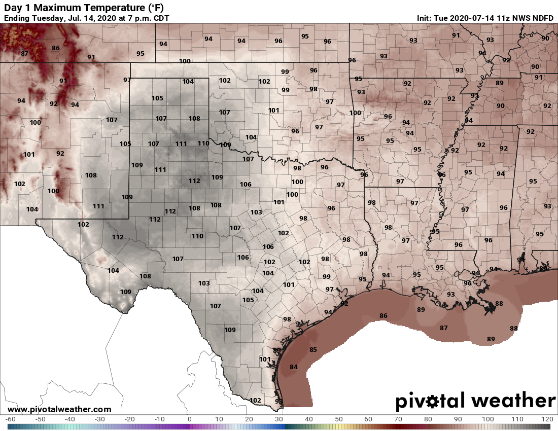
Today, however, will not provide too much of a change. Highs probably will still reach into the mid- to upper-90s for the region, with partly to mostly sunny skies this afternoon. Winds from the south at 5 to 10 mph will provide a bit of relief, and then we will be in for another very warm night, with lows possibly falling into the upper 70s for inland areas.
Welcome to Eye on the Tropics, Powered by Reliant.
With the formation of Fay last week, we’re off to the fastest start on record in the Atlantic basin if you used named storms as your benchmark. Thankfully, we are setup right now for a bit of a quiet period, possibly through the end of July.
Tropical outlook in a sentence
We do not expect any tropical activity of note for the 7 days and probably longer.
Fast start should slow again
Two weeks ago, we had Edouard to discuss. Last week, we hinted at the risk that Fay could form. That happened, and now things are once again quiet in the tropics. We don’t see any sneaky system risk for the next 5 to 7 days, and nothing of note seems to be showing up beyond that. So we can exhale for the time being, and let us revisit 2020’s frenetic pace.
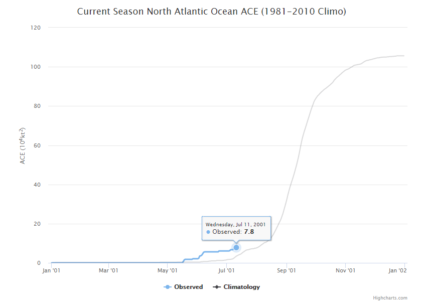
Fay was the fastest we’ve gotten to the “F” storm, or 6th named storm on record in the tropics, with the usual caveat that we easily could have missed a storm or two in previous years before weather satellites. Still, that is what the record books will say. Typically, we don’t get to the letter F until about September 8th. Of course, as we know, all of this year’s tropical storms have been fairly pedestrian in nature. The accumulated cyclone energy (or the sum of wind speed every 6 hours for every storm) is a mere 7.8, or what is typical for August 2nd.
The accumulated cyclone energy of this year’s hurricane season is running about 2 to 3 weeks ahead of normal. (Colorado State)
The earliest “G” storm is 2005’s Gert on July 24th. It seems unlikely that this domino will fall right now. So far at least, this year is about quantity, not quality. That isn’t a bad thing.
What is next?
The obvious question everyone will have is: If things are going to quiet down, when will we see the next wave of activity? The answer is that we don’t know. Now, I will say that the risk of activity over the next 5 to 7 days seems close to zero. However, once we go beyond that period, there is always a chance something rogue could develop local to the Gulf that is absent from all models at present. We don’t see any evidence of that being a risk right now, but folks should understand the time horizon we can reasonably forecast for is limited when it comes to these things. But at a large scale, things look to remain quiet for probably the next two weeks.
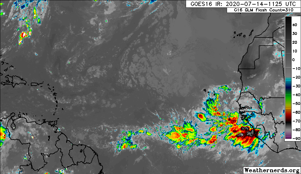
While there are some more robust tropical waves beginning to emerge off Africa, none right now looks to be a serious candidate for development. (Weathernerds.org)
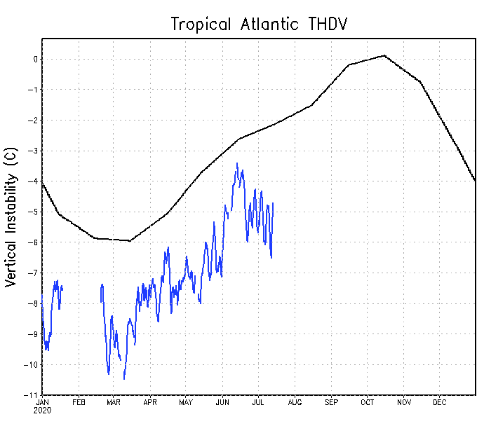
Dust is still pretty widespread, and even though we should begin to see beefier waves emerge off Africa, the odds of any one developing is fairly low. Looking at some meteorological data, it would seem to me that early to mid-August may provide our next chance to begin to get some development going on any meaningful scale. By then, dust and dry air should begin to become a little less dense, and we may see some background level support for more activity. One issue plaguing the Atlantic right now, despite a lot of other background signals being supportive of a very busy season is that vertical instability is rather low.
Vertical instability is lacking in the Atlantic basin right now, which may help hurricane season stay relatively lackluster for a bit longer. (NOAA)
We can use this as sort of a rough gauge as to what kind of state the Atlantic is in, and right now it happens to be in a pretty suppressed one, which does not support storm formation. Instability breeds thunderstorms, which can breed tropical storms. This doesn’t need to be rocking for the season to be active, but if you were seeking development of a meaningful nature, you would want to see this change. That being said, we’ve had six storms with really depressed basin-wide instability. If this does turn a corner, it’s likely that we’re going to be off to the races.
Hurricane season is a marathon, and there are numerous signals and hints you can focus in on or get distracted by. While this is a rather significant signal right now, and it’s likely helping us to keep quiet for the time being, it does not mean it will last forever. We will maintain vigilance. More for you next week!
Houston recorded its third 100-degree day of the year on Monday, when the high reached 101 degrees at Bush Intercontinental Airport. Hobby Airport also recorded its warmest day of the year, with the high hitting 99 degrees. Today will be another scorcher, but then our weather should gradually begin to modify toward more “normal” summertime weather in Houston. Later this week we’ll see the development of clouds, and even some modest rain chances as the high pressure system that’s been dominating our weather weakens.
Tuesday
Alas, there won’t be much (or any) relief today. We’re in for more hot and sunny conditions which should send highs back into the upper-90s—today is probably the region’s last day to break 100 degrees for awhile. Winds will be out of the south at 5 to 10 mph. And once again, overnight low temperatures will likely not fall below 80 degrees for much of the area, and only briefly if they do.
Tuesday’s forecast: Damn hot.
Wednesday and Thursday
These should be a pair of hot and mostly sunny days with highs in the mid- to upper-90s. Rain chances remain minimal, but overnight lows should be a degree or two cooler.
Friday
By week’s end a bit of an atmospheric disturbance may move through the area, and this will provide the region’s first real chance of rain in quite a while. I don’t want to oversell this as rain chances right now look to only be about 30 to 40 percent. And oftentimes, after an extended period of dry weather, forecast models will oversell rain chances. But anyway, the combination of scattered showers and a few more clouds should limit highs to about 95 degrees.
Saturday and Sunday
The weekend looks mostly sunny, with a slight chance of rain, and highs in the low- to mid-90s. This will feel more like a typical July weekend in Houston.
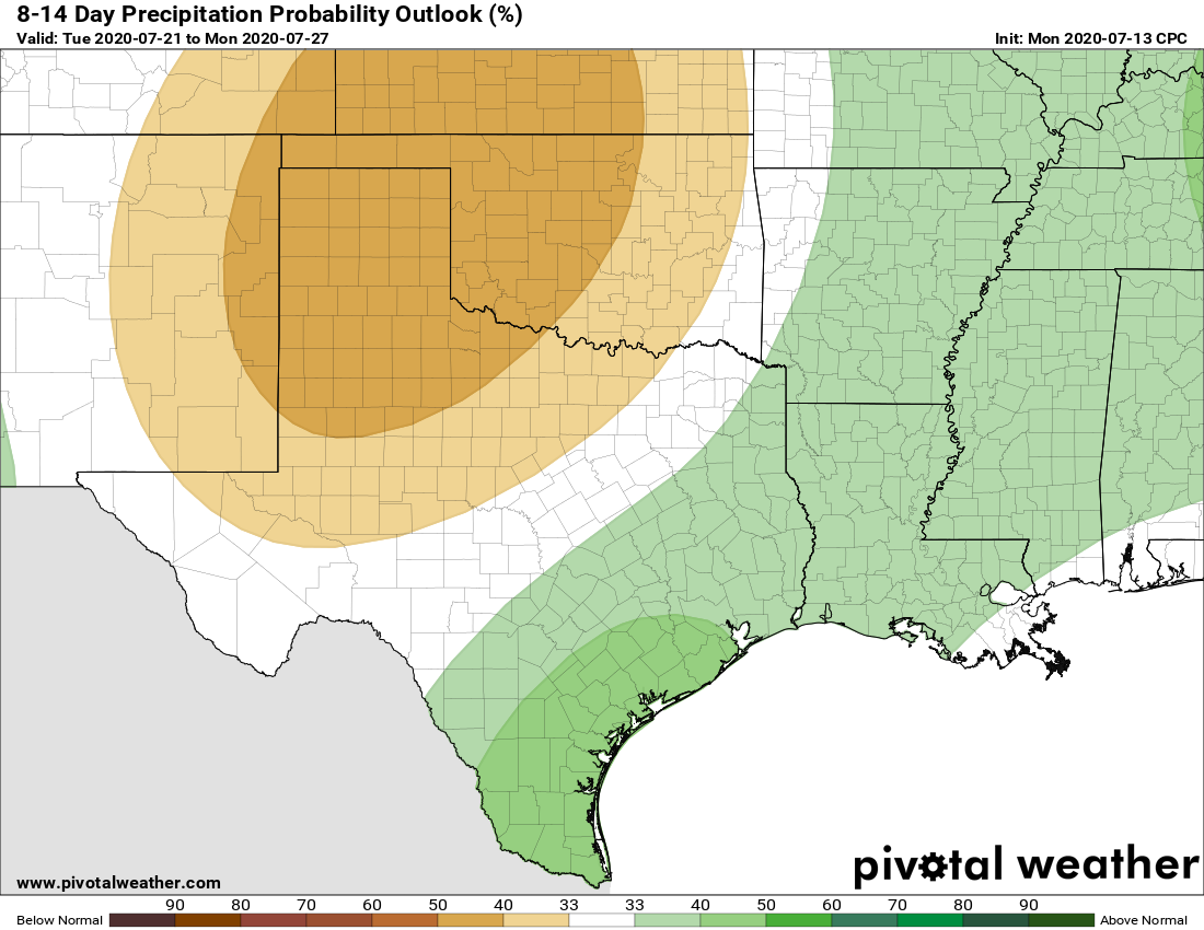
Our weather pattern should turn a bit wetter next week. (Pivotal Weather)
Next week
The pattern next week does look more favorable for rain, with high pressure displaced. Expect highs in the low- to mid-90s with decent rain chances beginning on Monday or so.
Good morning. Do you remember the brutal summer of 2011? If not, that was the warmest summer on record in Houston—high temperatures failed to reach 100 degrees on exactly one day in August of that year. Most of us who lived through it will probably never forget it.
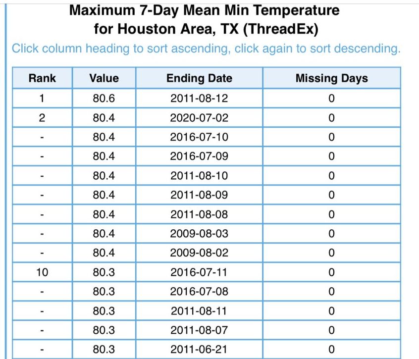
Well, during the last week Houston has had warm nights that rival the summer of 2011. Matt found that the week ending Saturday morning capped off the warmest 7-day stretch of minimum temperatures on record in the city. For the last 7 days low temperatures have averaged 80.7°. The previous record is 80.6° set in 2011.
Warmest 7-day average minimum temperatures in Houston. (National Weather Service)
That gives you some sense of the magnitude of heat we experienced last week, and which will continue this week. To that end we wanted to remind you that today through Wednesday is the very last chance to enter phase 1 of Reliant’s sweepstakes to win a free AC System. Please visit here to enter for your chance to win. Good luck!
Monday
By now you know the drill as high pressure dominates our region’s weather. Highs today will again be in the upper 90s, with partly sunny skies in the morning giving way to mostly sunny skies during the afternoon. Winds will be light out of the southwest. Overnight lows ill provide scant relief from this weather, possibly not dropping below 80 degrees.