Summer’s sizzle slogs along for Houston

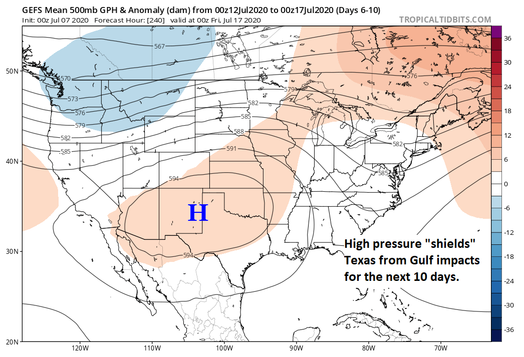
Thursday was officially the hottest day of 2020 so far. We topped off at 98º yesterday at Bush Intercontinental Airport and 96º (good for second hottest) at Hobby. The forecast for the next week is what we in meteorology call a “persistence” forecast. It is what it sounds like. Today will be a similar version of yesterday. Tomorrow will be similar to today. And so on. While it makes for easy forecasting, it can get old fast, especially when it’s this hot. Alas, let’s focus on those temperatures.

Today through Monday

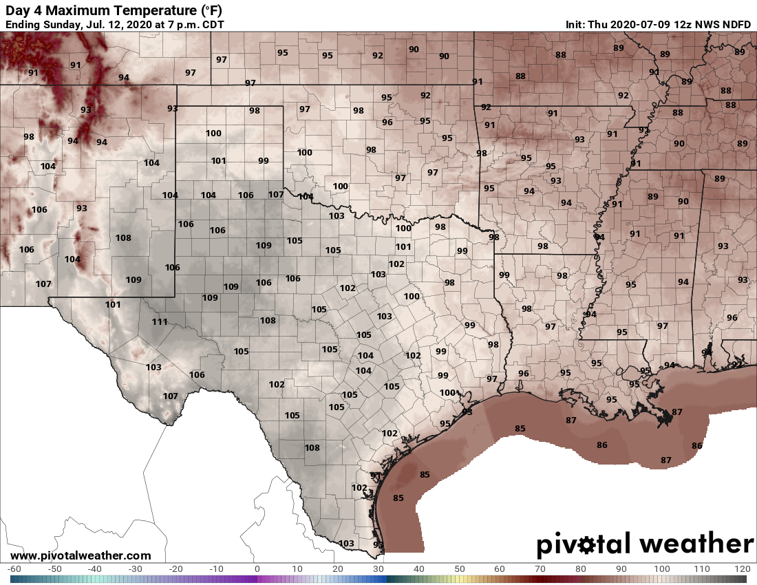
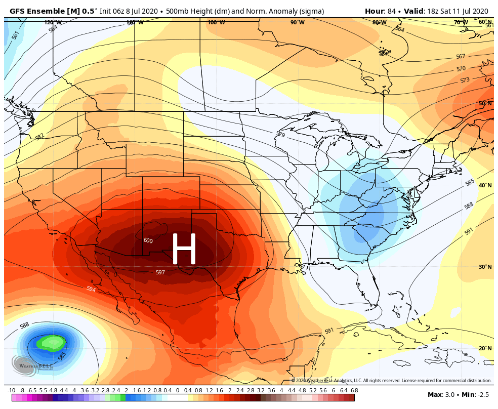
We will call it partly to mostly sunny through Monday. Upper air temperatures slowly escalate today and tomorrow. They should peak on Sunday and Monday, supportive of high temperatures in the low-100s for Houston. Inland areas will be slightly hotter, while coastal areas should do the mid-90s. Overnight lows struggling to get much below 80º will compound the intensity of the heat. Coastal areas likely will not drop below the low-80s.

Heat index, or what it feels like when you combine the heat and humidity will top off in the upper 100s to mid-110s this weekend. Heat Advisories are likely all weekend. (Weather Bell)

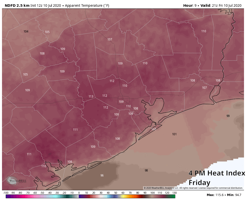
In terms of heat index values, it will be all the worse. Look for our heat indices (or “feels like” temperature if you prefer) to top off around 105º to 110º today and tomorrow afternoons, if not a little hotter. It is possible that we will see heat indices peak in the 110º to 115º range on Sunday and Monday. It’s going to feel miserably hot. A Heat Advisory will go into effect at Noon today, and we will likely see it reissued for Saturday, Sunday, and Monday afternoons. We don’t often talk about heat safety here because, let’s face it, it’s always hot here in summer. This will be next-level sort of heat, even for us, so please remember to drink plenty of water, check the backseat before locking, limit outdoor time in the afternoons, and check in on your neighbors that are elderly or vulnerable.

Tuesday through Thursday

The thermometer is going to take its foot off the gas after Monday. While Tuesday through Thursday should still be plenty hot, look for high temperatures to de-escalate from the low-100s back into the upper-90s. Rain chances appear to remain close to zero through Thursday. Our next real chance of some kind of rain is likely not until next Saturday or so.

Another one bites the dust

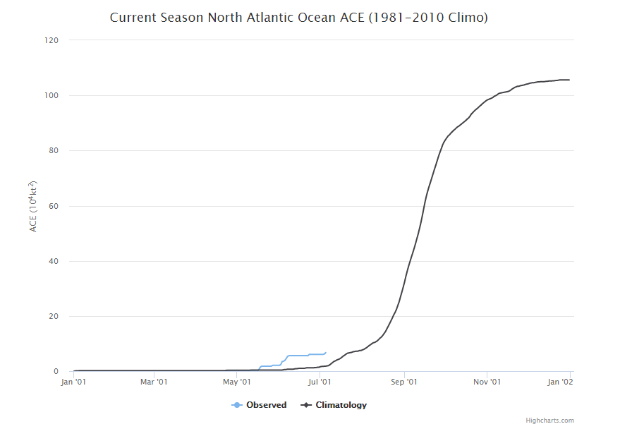
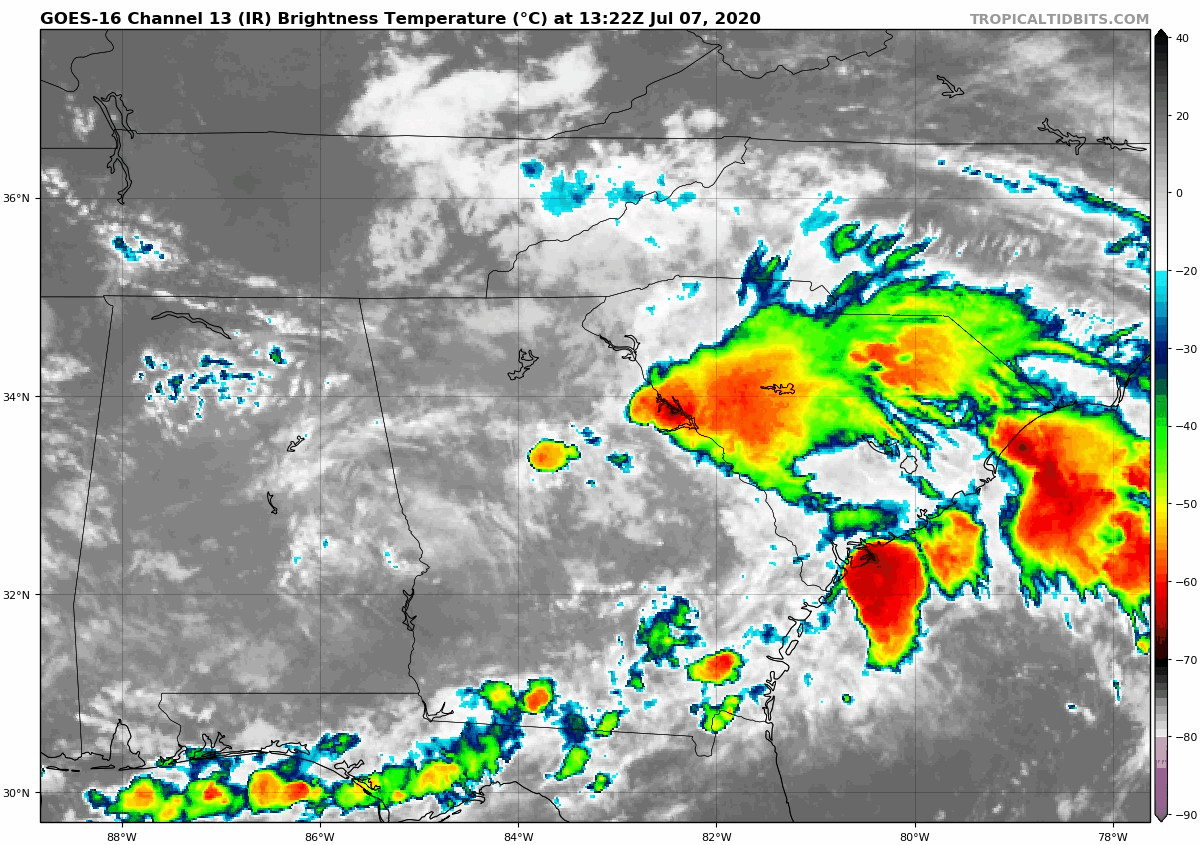
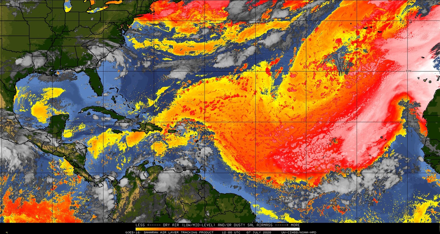
Tropical Storm Fay formed yesterday afternoon, becoming the earliest “F” storm (or 6th named storm) on record in the Atlantic Basin. It broke the record previously held by Franklin on July 21, 2005. It also would have broken the old record for earlier “E” storm too had Edouard not beat it to the punch this past weekend. As we’ve noted, in terms of intensities of these storms, 2005 blows this year away, as all of this year’s storms have basically been middling tropical storms thus far. We will discuss this some more in Tuesday’s tropical update.

Tropical Storm Fay has some gusty winds but should not cause any serious widespread problems in the Northeast. (NOAA)

Fay will deliver a dose of gusty winds and heavy rain to the Northeast Corridor, with flood watches hoisted from Delmarva through southern New England. Up to 4 to 6 inches of rain is possible in some locations. Overall, Fay should be equivalent to a moderate nor’easter with a bit more rain, so no significant problems are expected up that way.

For those curious, the earliest “G” storm (7th named storm) also occurred in 2005 and was Gert on July 25th. As of now, we don’t see any legitimate candidates for tropical development over the next 7 to 10 days or so.

Unrelenting heat for the next week in Texas

By now you know the drill for our upcoming weather: Houston and the rest of Texas will feel the influence of a large area of high pressure over the coming week, with heat likely peaking this weekend. Rain chances are effectively non-existent for at least the next seven days, and likely longer.

Thursday and Friday

A mix of clouds and sunshine will help to moderate temperatures slightly, keeping high temperatures in the mid-90s. South winds of about 10mph will offer only a little relief from the heat and humidity, and overnight temperatures will only drop into the upper 70s. Rain chances are near zero.

Saturday and Sunday

The weekend looks extremely hot, with most areas except the coast potentially reaching 100 degrees. Expect sunny days and clear nights.

Almost the entire state of Texas should reach 100 degrees on Sunday. (Pivotal Weather)

First half of next week

The pattern remains more or less the same. Temperatures may back off slightly into the upper 90s, but it will still be hot-hot-hot with ample sunshine.

When does this pattern change?

We’re likely locked into this pattern through at least Thursday or Friday of next week before the high pressure may ease off, allowing for clouds to develop, and bringing back at least the potential for some rain showers. Stay safe, y’all.

Here comes the heat, Houston

Good morning. A few areas saw rainfall on Monday—Cypress was one big winner near Houston with nearly 1 inch of rain—but now the atmosphere is pretty much going to lock down for awhile. As high pressure builds to our west, it will prevent rising air, trapping moist, humid, and very hot conditions at the surface. It looks like the heat will peak this weekend, when 100-degree days are possible.

Wednesday, Thursday and Friday

The next three days will see a mix of clouds and sunshine. Because some clouds will linger, they should help to moderate temperatures slightly, keeping highs in the mid-90s. Winds will be out of the south at 10 to 15 mph. Overnight lows will provide little relief, likely falling into the upper 70s for inland areas, and remaining at or above 80 along the coast. There is about a 10 percent chance of a stray shower developing before high pressure really settles in over the weekend.

High pressure will build to a maximum this weekend. (Weather Bell)

Saturday and Sunday

By this weekend high pressure will reach its maximum extent over the southwestern United States. For Houston this means hot and sunny weather, with highs in the upper 90s to 100 degrees. Winds will generally be light. This should be the hottest weather we’ve experienced so far in 2020, so please take care outside with the heat.

Next week

Very hot weather continues to start next week, but temperatures should begin to moderate a bit later in the week. The forecast still looks very dry rain-wise until next Thursday or Friday at the very earliest.

Tropical Update: 2020 continues to pile up storms and set new records

Last week, we discussed how 2020 had started off tremendously fast but slowed a bit. We’re coming out of that lull now, but thankfully what we are amassing is mostly curiosity rather than any serious impacts.

Tropical outlook in a sentence

While another system is possible off the East Coast, the Gulf is not expected to deliver any action over the next 1 to 2 weeks, as summer roasts much of Texas.

Edouard sets another 2020 superlative

With Tropical Storm Edouard being named on Sunday night, the Atlantic has now set a new record for the earliest 5th storm on record. The previous record holder was Emily back in 2005, which formed on the 11th of July. We typically do not see our 5th storm until the end of August, so we are off to the races right now. We’ll discuss 6th storm records in just a moment.

Again, there’s a huge difference between utilizing number of named storms and accumulated cyclone energy (ACE) to characterize the start to a season. Please see last week’s post for an explanation of the value and shortcomings of ACE. From the named storm standpoint, we’re at late August levels already. From an ACE standpoint, we’re at July 20th levels, not super abnormal.

While named storms are up to typical late August levels already, accumulated cyclone energy (ACE) is only running about two weeks ahead of schedule right now, which is probably a more reasonable way to characterize the 2020 season thus far. (Colorado State)

Just to put this into a little perspective: In 2005, the year we keep beating for earliest storm, by the time the 5th storm dissipated on July 21st, we had amassed an ACE of 56, or what is normal for September 14th. As I’ve told some people, 2020 thus far is about quantity, not quality.

East Coast bias

Of this year’s five storms so far, four of them have formed near or off of the East Coast. Could our next system come from that area? It very well could. A disturbance dubbed “Invest 98L” moved ashore on the Florida Panhandle on Sunday night. It is currently over northern Georgia and projected to lift to the north and east over the next few days.

Invest 98L is disorganized over Georgia today, but it does have about a 40% chance of developing as it pushes off the coast later this week. (Tropical Tidbits)

Right now, the National Hurricane Center is giving this about a 40 percent chance at becoming a tropical system over the next few days as it lifts north and east off the East Coast. If it does become a tropical storm, it would be named Fay, and it would break the record for earliest 6th storm (Franklin on July 21, 2005). This disturbance should produce heavy rain on the coast of the Carolinas, but at this point, it is not expected to cause much serious trouble before rolling out to sea.

Saharan dust

We continue to see the bulk of the Atlantic basin littered with dust today.

Widespread dust continues to hold over most of the Atlantic Basin, but it has eased up in density and coverage a bit. (University of Wisconsin CIMSS)

Dust, while widespread, is beginning to ease up a little relative to late June. The good news for us in Texas is that the quantities of dust reaching the Gulf are slowly diminishing, so we’re not expecting quite as ugly of an impact from dust over the next 10 days as we saw in late June up through this past weekend. Still, as dust rolls west across the basin, it’s always possible we see some in our area. But we do have something extra working in our favor by this weekend.

Heat in Texas keeps the Gulf closed

Look, some of us like the heat this time of year. Many of us deride as just something we have to accept about living here. Sometimes the heat can be good for something, and in our case, it would seem that it will help shield us from any Gulf happenings, including Saharan dust over the next week or two. To be clear, we don’t really expect any Gulf happenings, but in the off-chance something could form, strong high pressure over Texas would most likely deflect anything back to the east or well south into Mexico. Below, you will see the GFS ensemble mean forecast for days 6 through 10 (Sunday to Thursday next week), which shows high pressure in the upper atmosphere oriented just right to keep Texas protected.

The upper air forecast for days 6 through 10 shows a rock solid, strong high pressure system over Texas, which should be enough to keep the region “shielded” from any Gulf impacts. (Tropical Tidbits)

Of course, that will come with a cost, assessed in triple digit temperature risk and heat index values. But as long as high pressure can hold over Texas, we’ll be pretty safe from the Gulf. We don’t expect that to last forever, but for the next week or two, it is expected to be quiet, albeit dry.

Our weekly tropical roundup is Powered by Reliant.