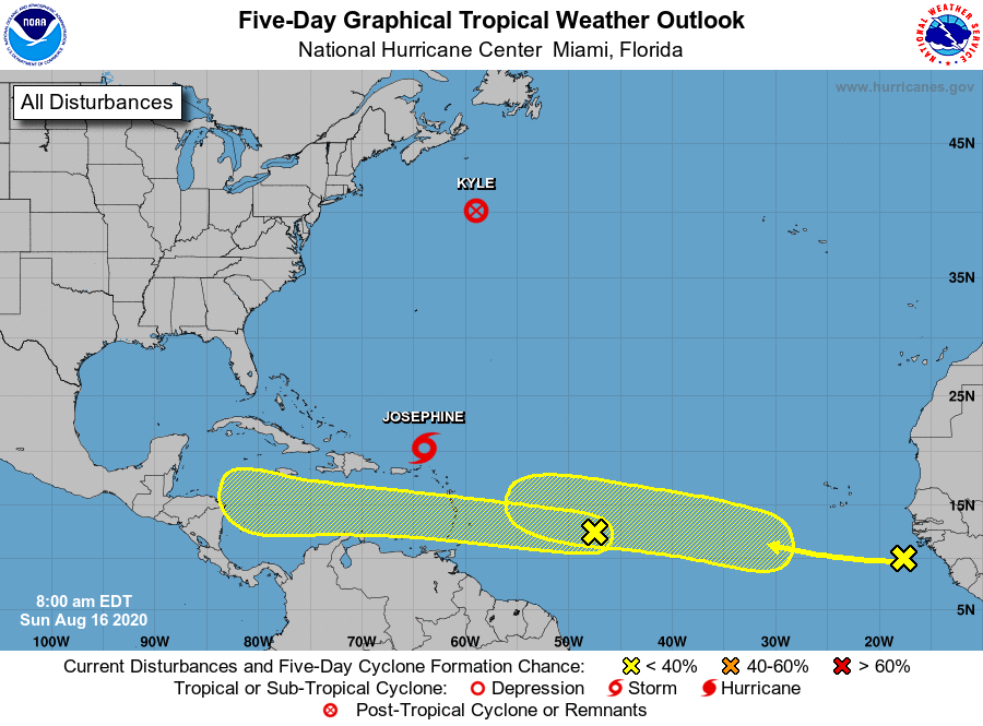
Over the last week a pair of non-consequential tropical systems have formed over the Atlantic—Tropical Storm Josephine, which is weakening at sea, and Kyle, which has already dissipated. However as a more favorable pattern for rising air moves into the deep Atlantic tropics we can expect to see storms firing up in the main development region between the west coast of Africa and the Caribbean Sea. This indicates we likely will see stronger hurricanes begin to develop in the coming weeks.
To that end, the National Hurricane Center has begun tracking two areas of interest that are moving generally westward across the Atlantic Ocean, toward the Caribbean Sea.
If we take a look at the satellite image this morning, we can see that both of these tropical waves are not yet close to becoming organized. And looking at some global model forecasts, neither of these are slam-dunk systems in the sense that they’re guaranteed to eventually develop into tropical storms or hurricanes.
Annotated satellite image from 8am CT Sunday. (NOAA)
However, it does seem likely that at least one of these systems, or another wave yet to move off Africa, will find the right conditions over the Atlantic, move into the Caribbean Sea, and eventually threaten the Gulf of Mexico. That is certainly what we’ll be watching for over the next few weeks. We’ve been telling you for awhile that the latter half of August and September will be likely busy in the tropics. Now, that time is at hand.
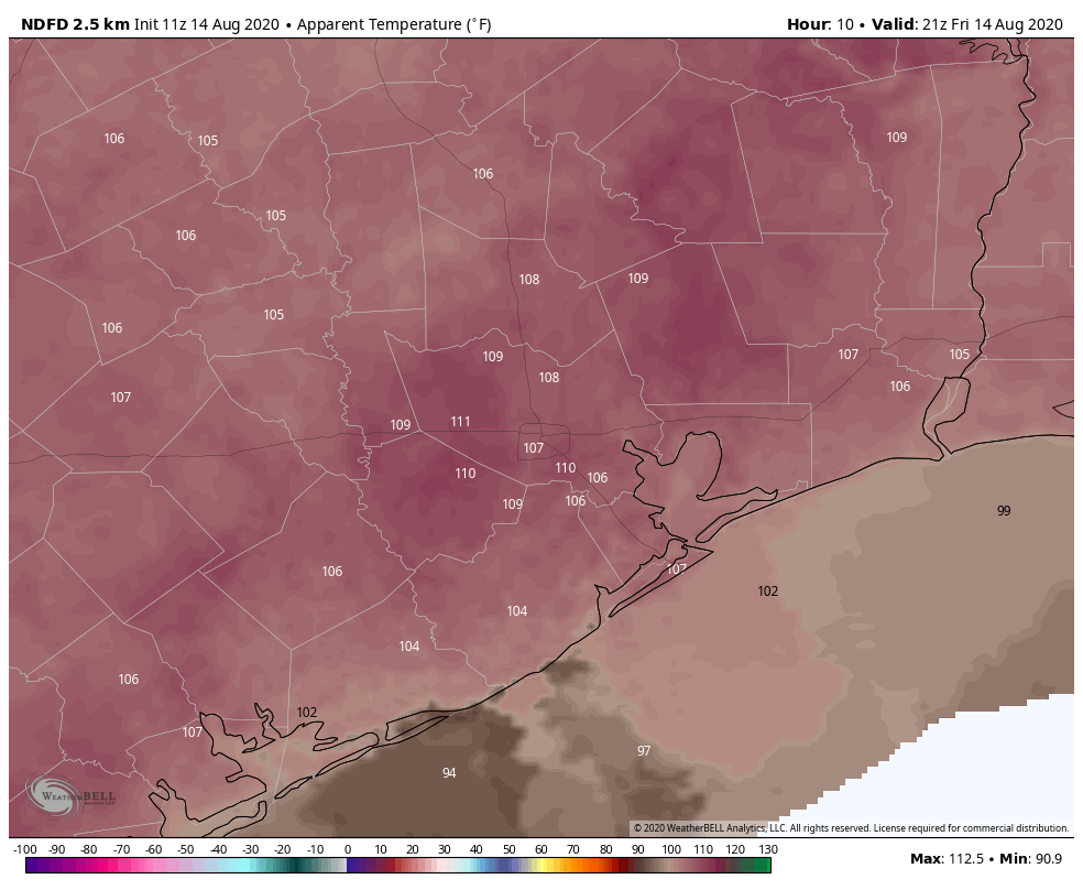
The meteorological phenomenon we call “August” has mostly lived up to its normally unpleasant expectations so far in the Houston area. After hitting 101° on Wednesday, we topped off at 99° yesterday. Overnights have been especially oppressive, with Galveston tying an all-time record warm low temperature on Wednesday and Hobby Airport blowing through its record for most 80 degree mornings in a year already. We will have a post with a lot more on this coming soon. In the meantime, we expect no relief this weekend, but there are signs we should begin to cool off a bit next week. Let’s discuss.
Today through Monday heat
A heat advisory continues for the entire region both today and tomorrow, and we would not be shocked to see it extended into Sunday and/or Monday as well. Expect mostly sunshine with highs near 100, lows in the 70s to near 80°, and heat index values of 105° to 110° or even briefly hotter at times.
Heat index values at 4 PM today will be quite high, topping off near 110° in many areas. (Weather Bell)
Take it slow and easy in the heat this weekend.
Rain chances and a front next week?
As far as rain chances go, we should not see anything other than an isolated pop-up shower or storm today and tomorrow. If the chance of a shower is about 10 percent Friday and Saturday, maybe it inches up to 15 or 20 percent Sunday.
Monday and Tuesday are complicated by a cold front in the area. Don’t expect anything refreshing next week, but we should see a shift to “less hot” weather and a better chance of scattered showers and storms early. Monday would still be hot with scattered showers and storms in the afternoon. The trade off with a cold front possibly pushing through is that rain chances would drop off again behind the front for later Tuesday and Wednesday. Still, we’ve got a few things to work out regarding the timing of the front and just how high rain chances look. We’ll update you Monday.
Behind any sort of front, we would see high temperatures “only” in the mid-90s and less oppressive heat index values. Lows would be more in the 70s for most.
Tropics
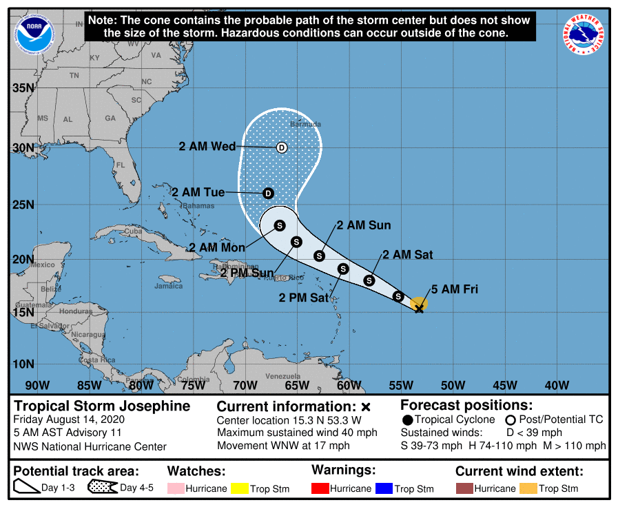
Tropical Storm Josephine formed yesterday in the open Atlantic, the earliest 10th or “J” storm on record by almost 10 days.
Tropical Storm Josephine looks to be weak and a “fish” storm. (NOAA)
Josephine will likely begin to get steered to the north as it passes the islands and is no threat to the U.S.
The only other disturbance outlined by the National Hurricane Center (Invest 96L) is a disturbance off the North Carolina coast that will slide out to sea over the next few days. We expect another wave or two to emerge next week as candidates for development, but it’s far too early to speculate on any other details. We just know it’s likely going to get and stay active.
For those of you scoring at home, the earliest eleventh, or “K” storm was Katrina on August 24, 2005. The earliest “L” storm was 1995’s Luis on August 29th, part of a barrage of storms in the Caribbean islands that year.
Our forecast is going to be very hot, with heat advisories likely needed through the weekend. Before jumping into the details, such as they are, I wanted to say a word about Hurricane Ike.
We are, amazingly, coming up on the 12th anniversary of Hurricane Ike. If you don’t remember, the storm hit Houston fairly hard, but made landfall just far enough east of Galveston that the worst of its storm surge missed Galveston Bay. It represented an enormous wake-up call for the region in terms of vulnerability of coastal residents, as well as the Houston Ship Channel. Unfortunately, while we have studied the problem in depth, we have yet to commit to any major projects that would address the threat and mitigate surge. There are two main proposals: A Coastal Spine Project led by the U.S. Army Corps of Engineers and the General Land Office, and an astonishingly beautiful Galveston Bay Park that would protect the Houston Ship Channel from a 25-foot storm surge.
Visualization of park space that would exist on Galveston Bay Park. (SSPEED Center)
While we certainly realize that America and Texas have a lot of other problems to deal with at present, it is time to pick one, or both, of these projects to move forward with for the good of the greater Houston region. Otherwise, we may not get so lucky with the next large hurricane that makes landfall along the upper Texas coast.
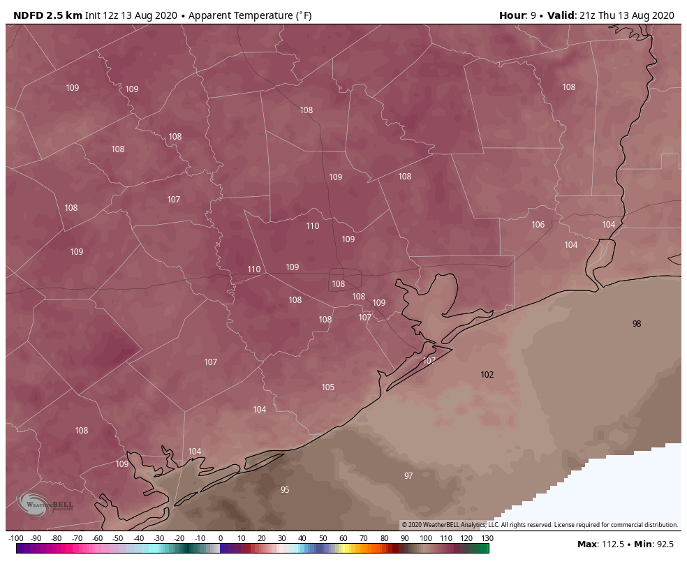
Thursday
Houston’s high temperature hit 101 degrees on Wednesday at Bush Intercontinental Airport, and we can probably expect more of the same today with mostly sunny skies. The National Weather Service has issued a heat advisory for now through Friday evening, and in truth it probably will be extended through the weekend as high pressure continues to influence our weather. Southwest winds of 5 mph will provide very little cooling today. Nights will remain sticky and warm.
Heat Index temperatures will again be smoking hot on Thursday in the region. (Weather Bell)
Friday, Saturday, and Sunday
More. Of. The. Same. It’s probably worth mentioning that we could see a few isolated showers pop up during the afternoon, with daytime heating. I’d sure welcome one, but it seems a forlorn hope at this point.
Next week
The heat should back off somewhat by Tuesday, as some sort of weak cool front approaches the area. We still don’t have great confidence in how far this front will reach, but it should help to increase rain chances by Monday night or Tuesday, and then knock back daytime highs into the low- or mid-90s. We’d love to get some dry air to help with nighttime temperatures, but I’m not ready to bet on that yet.
Good morning. Temperatures will be hot enough today that the National Weather Service has issued a heat advisory for now through 7pm CT. This means the hot temperatures and humidity will combine to create a heat index of up to 110 degrees later today. We can probably expect more of the same for the remainder of the week as high pressure influences the region’s weather through the weekend. Some relief should come next week.
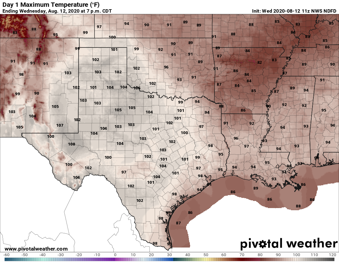
Wednesday will be a very hot day in Houston. (Pivotal Weather)
Wednesday
High temperatures today will likely reach near 100 degrees for inland areas, with lower-to-mid 90s along the coast. Expect mostly sunny skies, although there will be a slight chance of showers and thunderstorms later this afternoon. Winds will be light, at 5 to 10 mph out of the southwest. Our trend of warm nights will continue, with many areas south of Interstate 10 not falling below 80 degrees tonight.
Thursday and Friday
With conditions more or less the same for the remainder of the work week, I’d anticipate the National Weather Service extending heat advisories for both of these days.
Saturday and Sunday
We don’t really anticipate much change this weekend, either, with only slight—roughly 20 percent—rain chances both days. Otherwise skies should be partly to mostly sunny, with highs in the upper 90s to possible 100 degrees for inland areas. Overnight lows will provide scant relief.
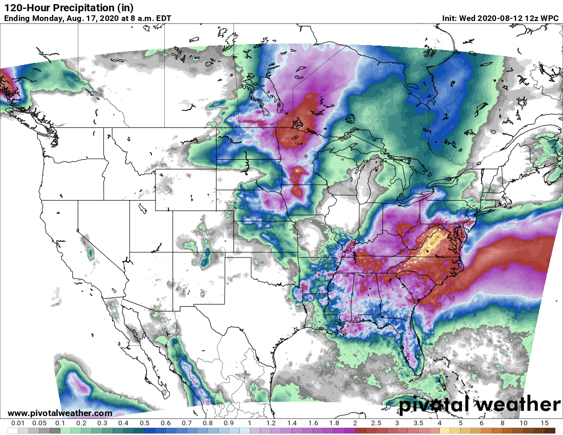
The rain accumulation forecast for now through the weekend is near zero. Chances improve after that. (Pivotal Weather)
Next week
Things may get a little more interesting next week as high pressure backs off some. Rain chances may increase by Monday or so, perhaps into the 30 to 40 percent range. And I’m not ready to fully buy into this yet, but the models bring a front into Texas and push it toward Houston on Tuesday or Wednesday of next week. The jury is out on how far the front will push into Houston, and whether it will make it all the way to the coast. Typically this does not happen in August, but if it does we’ll see some pleasantly drier air. We’re not going to get crazy here, but instead of nighttime temperatures of around 80 degrees, they may drop into the lower 70s in the city. We’ll see.


