Eye on the Tropics: Watching and waiting

Welcome to mid-August. We’ve passed the first couple of months of this hurricane season in the Houston area without too much heartburn. The good news today is that we don’t have much specific on our radar that is of concern for the Gulf. The bad news is that we are anticipating that by late August there will be multiple areas to watch.

Tropical outlook in a sentence

A disturbance that may develop in the Atlantic is not a concern for us at this time, however we see signs on models that multiple tropical waves will be worth monitoring heading into late August.

Invest 95L

The disturbance in the Atlantic that is the most pressing at the moment is tagged as Invest 95L. It’s pretty far out there still, about 1000 miles west of the Cabo Verde Islands, or a little short of halfway to the Caribbean.

The National Hurricane Center has boosted odds of development in the Atlantic to 90 percent with Invest 95L, and a depression may form before the end of today. (NOAA)

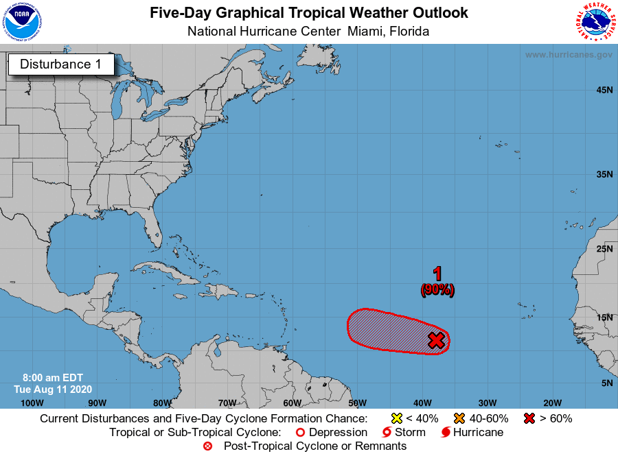
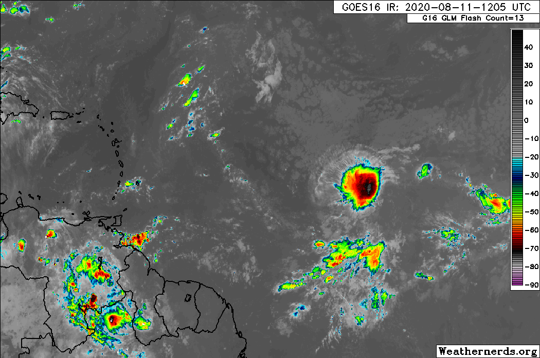
As of Tuesday morning, the National Hurricane Center says it has a 90 percent chance of developing into a tropical system over the next two to five days. On satellite today, 95L has a decent area of thunderstorms associated with it, but it seems to lack any kind of organization at this point.

Invest 95L has a solid area of thunderstorms associated with it, but it lacks much organization to this point. (Weathernerds)

The window for Invest 95L to develop is fairly narrow. We expect whatever it becomes to run into some serious wind shear as it moves toward the Caribbean. In addition, the system should be steered west around high pressure in the Atlantic, with a weakness in that ridge allowing it to gradually gain some latitude. We feel that will be enough to either allow for an escape out to sea or to dissipate the system well before it gets to the U.S., and we probably wouldn’t register this as something you need to worry about for the moment.

See full post

Announcing the first winner of Reliant’s 2020 AC Sweepstakes

We’re thrilled to announce that lifelong-Houstonian James Young has won a free AC System from Reliant. As you may recall, this is the second year of this promotion that Reliant has offered to readers of Space City Weather. James’ previous system was 20 years old, and let’s let him take it from here:

“A few weeks ago, my neighbor was searching for a new electricity provider. He asked me if I was pleased with my Reliant plan and I said, ‘Yes, I couldn’t be happier!’ Well, I was wrong! When I heard I was the winner of Reliant’s 2020 Summer AC Sweepstakes, I was happy beyond belief! I had a Ruud system that was over 20 years old.  Knowing that it was replaced with a new, Ruud high-efficient unit brings me great peace of mind. I send my sincerest thanks to Space City Weather, Ruud for their great products and Reliant for their great installation, reliable power and fantastic customer service. I’m looking forward to having the ‘coolest’ summer that I’ve had in a long time!”

James is the winner of Phase I of this sweepstakes. If you’ve already entered to win, you’re set for Phase II, which ends on September 15. But if you haven’t entered yet, there’s still time to do so by visiting here. Full contest rules are also available at the link.

High pressure to our west? For Houston, a humidity fest.

This is a pretty easy forecast for the region, and as there’s not much to say, we’re not going to say much. The prevailing pattern remains the same, with a ridge of high pressure anchored generally over the four corners region. For the next five or six days, this overall pattern does not change, with the ridge likely slowly moving north, and then a bit west. Houston lies on the eastern edge of this high, but we’ll feel enough of its influence to preclude all but isolated to scattered showers. In short, we’re going to see typical August weather for awhile.

Note the position of the high pressure system over southern New Mexico, Texas, and Arizona today. (Weather Bell)

Tuesday

Today will be mostly sunny, with highs in the low 90s near the coast, and upper 90s for inland areas. If you’re far enough west or north of Houston, highs may flirt with the 100s. Winds will remain very light, at about 5mph out of the south, providing no relief during the afternoon. Rain chances will be slight, at 10 to 20 percent for the region. Overnight lows will be warm and humid.

Wednesday and Thursday

More of the same.

Friday, Saturday, and Sunday

The overall pattern does not change much, but as atmospheric moisture levels rise a bit, we may see slightly better rain chances in the mix. Forecast models also indicate this is when temperatures may reach their warmest—with the potential for 100-degree weather creeping southward into the Houston metro area—so expect plenty of heat and humidity to go along with any scattered showers.

By Sunday the high has moved to Arizona, Utah, and Nevada. (Weather Bell)

Next week

By next week the high should continue to move west, and this may open the door to a more disturbed atmosphere with better rain chances. This probably will begin around Tuesday or so, but we’re not making any guarantees.

Houston will experience Groundhog Day weather this week

Good morning and welcome to a new week. There remains little exciting to say about our region’s weather as this week will feel like Groundhog Day, with conditions each day more or less like the last. Sure, a few areas may see a stray shower or thunderstorm during the afternoon hours, but for the most of us, it will be hot and mostly sunny. The good news remains that, one does not really enjoy the weather during August in Houston—one survives it. And given that we are unlikely to face triple-digit heat or widespread floods over the next week, it is difficult to complain too much.

Highs on Monday will definitely feel like August in Texas. (Pivotal Weather)

Monday

Houston remains on the periphery of a high pressure system anchored to our west, and this should both prevent temperatures from getting too hot, while also allowing for a few sea breeze showers to develop during the afternoon hours and move inland. Look for high temperatures in the low 90s along the coast, with temperatures in the mid- or upper 90s for far inland areas. Light, southerly winds will offer little relief. Nor will nighttime temperatures. With lows of only 80 degrees last Thursday, Friday, and Saturday, Hobby Airport tied record for overnight heat and we should remain nearly as warm.

Tuesday and Wednesday

This will be a pair of mostly sunny days, with high temperatures in the mid-90s, along with more warm nights. Again we may see a few coastal showers develop during the afternoon, and progress inland.

See full post