Tropical Depression 14 likely headed for the Gulf but we still have more questions than answers

Good afternoon. Tropical Depression 14 formed late this morning from the disturbance previously dubbed Invest 97L. This is the primary system we will watch over the next few days as it moves toward the Gulf. Here’s a brief rundown of what we know and, more importantly what we don’t know.

Now

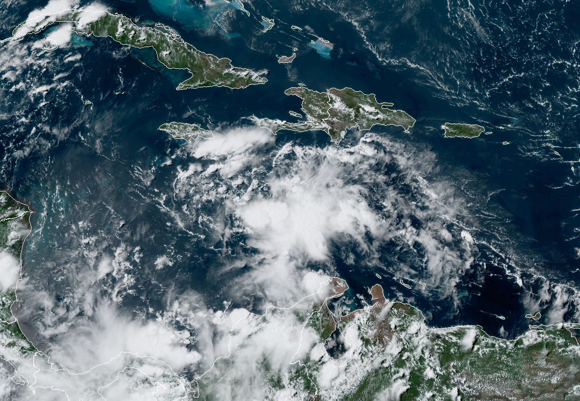
Tropical Depression 14 is located east of Honduras and south of Cuba over the western Caribbean Sea.

Tropical Depression 14 is moving west across the western Caribbean. (Weathernerds.org)

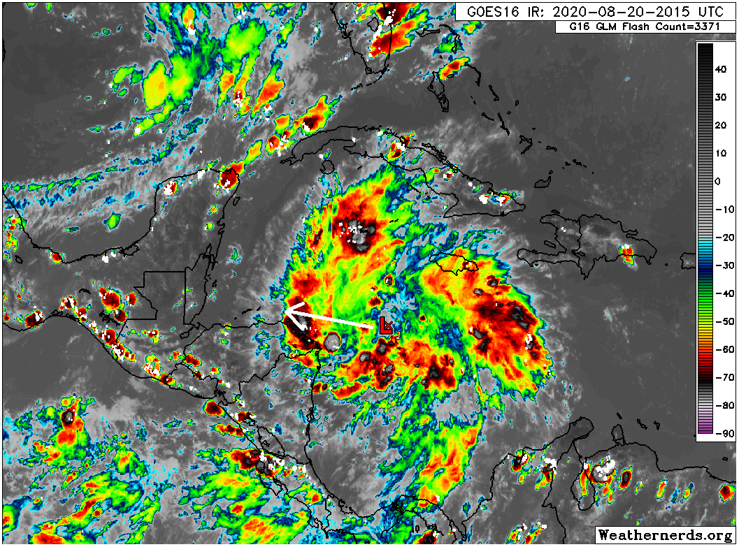
It’s basically what you would expect from a tropical depression: sort of messy, but with numerous storms both east and west of the center, so it’s not terribly asymmetrical.

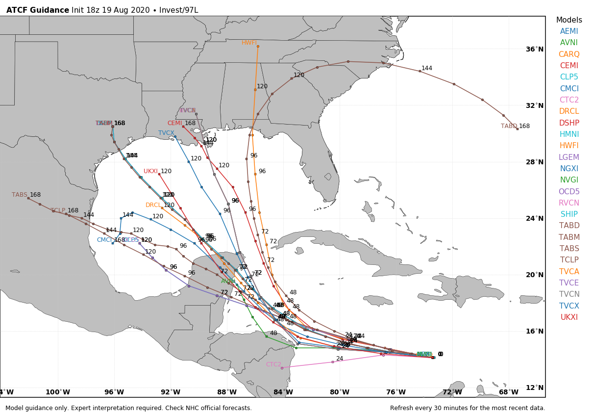
The latest forecast from the National Hurricane Center has the system moving into the Gulf and remaining a tropical storm through early next week.

The official National Hurricane Center forecast cone for TD 14 brings it broadly toward the Texas or Louisiana coasts by Tuesday. (NOAA)

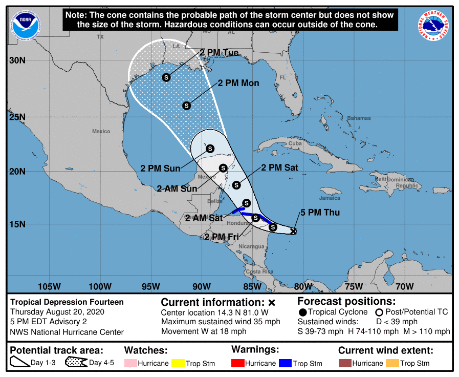
It’s important to note that while a “center line” points this right at Houston, the cone is the cone for a reason. The storm may track well to our east or well to our southwest. Our impacts here in Houston would vary considerably based on that, so this map should not be considered a license to panic or to write it off entirely.

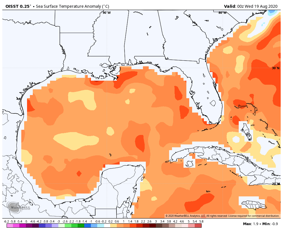
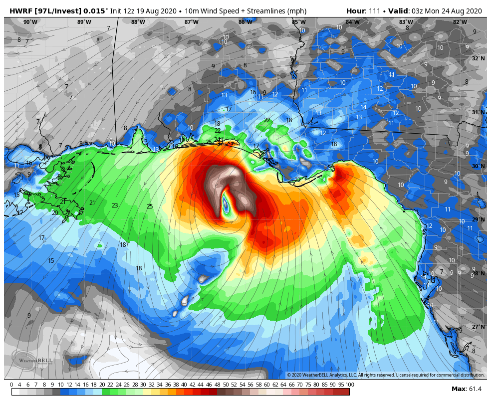
Over the next two days, TD 14 will enter an environment that’s pretty conducive for strengthening. Shear will continue to relax. As it moves toward the Yucatan Peninsula of Mexico, look for this to intensify into a tropical storm and possibly a hurricane. Water temperatures in the western Caribbean are more than supportive of strengthening.

Sea surface temperatures are above normal everywhere in the Gulf and Caribbean, more than supportive of strengthening as TD 14 moves through. (Weather Bell)

Once it gets to the Yucatan and beyond, the questions begin to mount quickly.

Here is what we know:

We know that TD 14 should move across the northeastern part of the Yucatan Sunday morning. We know it will likely be at least a tropical storm. We know it will be pulled north by a trough over the South and nudged west by the Bermuda high as it expands westward across Florida. We know that if impacts occur in Houston, they would likely begin Monday night or Tuesday.

Here is what we don’t know:

We do not know where TD 14 will ultimately end up and how strong it will be when it gets there. I know this makes you throw your hands up in the air in frustration, but those are the realities.

We do not know how much wind shear TD 14 will encounter over the Gulf. As the trough over the South weakens and pulls out, there will be some wind shear left behind. If that ends up over the Gulf, that will help mitigate TD 14’s ultimate strength. If that wind shear goes north as the storm comes north, then we need to watch for TD 14 to intensify more significantly.

We also don’t even fully know how much land interaction TD 14 will have near Honduras and Mexico. The latest advisory suggests TD 14 is farther south than originally thought, so that is something that could ultimately impact the system.

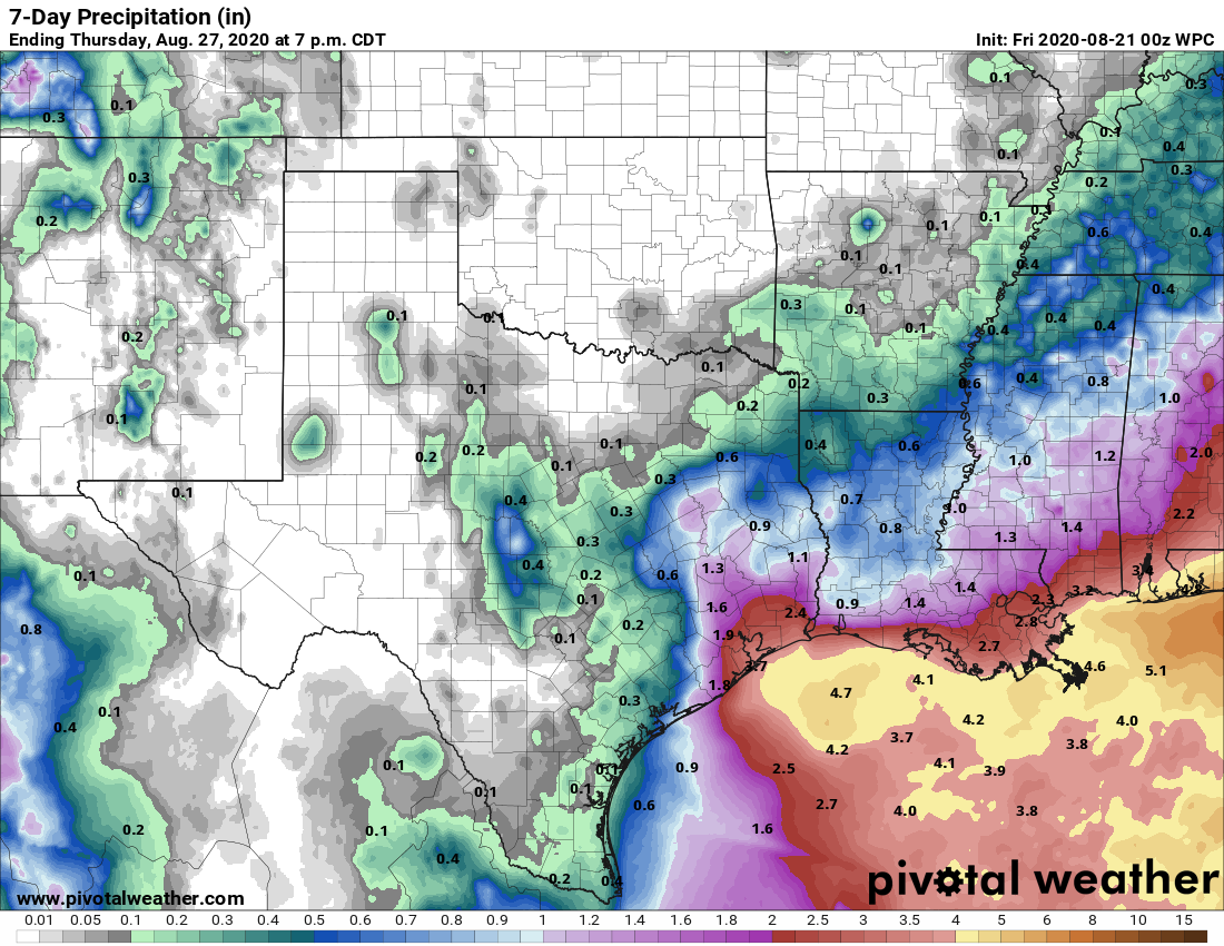
We don’t know how much rainfall we will see, as it will depend on how organized TD 14 becomes and exactly where it goes.

We don’t know how TD 13 may impact what happens with TD 14, so there’s a good deal of uncertainty there.

More ambiguous things we can say:

A stronger storm would likely go to our east, whereas a weaker one would come closer to us. But weaker does not necessarily mean “weak,” so keep that in mind.

We do not expect a stall/Harvey scenario at this time or even an Imelda one but we are not entirely sure how things will play out. Flooding is possible in any tropical system, so we cannot rule any sort of flooding out right now.

The current rainfall forecast from NOAA stops on Thursday evening and shows the heaviest rain offshore, but some risk of heavier rain perhaps toward Houston with TD 14. Total rainfall will ultimately depend on the exact track and speed, things yet to be determined. (Pivotal Weather)

We should be able to narrow the cone a bit in the morning, and we should know a lot more later tomorrow and Saturday morning. So stay tuned.

Confidence growing in Texas impacts from TD 14 [Updated]

10:00am CT Update: The National Hurricane Center upgraded this system to Tropical Depression 14 on Thursday morning. Our forecast below remains accurate. Matt will be providing a big-picture update this afternoon.

Original post: This update will consist of both a short weather outlook about the rest of this week, and a longer section on the threat posed by the tropics. In short, the latest model guidance suggests an increased likelihood that Invest 97L may impact Texas, although much uncertainty remains. We’ll also have to keep an eye on Invest 98L, although this seems a bit more of a distant threat.

Thursday

Today’s weather will be a lot like Wednesday’s, which is to say hot and sunny, with high temperatures in the mid- to upper-90s. With slightly drier air in the region, conditions won’t feel quite so humid this morning or this evening, but as an easterly, and southeasterly wind develops this afternoon we’ll feel the beginnings of an onshore flow. A few stray showers may develop near the coast today. Low temperatures will fall into the mid- to upper-70s.

Yep, it will be hot again on Thursday in Texas. (Pivotal Weather)

Friday, Saturday, and Sunday

Honestly, we don’t anticipate a whole lot changes with our weather and this August-like pattern, except that the onshore flow will return more humidity at the surface. We’re going to see hot days in the mid-to-upper 90s with oodles of sunshine and only very slight rain chances with coastal counties the most likely areas to see precipitation.

Next week

Our weather next week will depend to a large extent on Invest 97L, but the bottom line is that we may see increasing rain chances by Monday or Monday night. This is probably a good time now to talk tropics.

See full post

Our latest forecast for Invest 97L is basically a shrug emoji

Good afternoon. We’re continuing to follow activity in the tropics, and are focusing on Invest 97L. This is because it is the closer system and more immediate “threat.” That said, I’m afraid there’s not much useful intelligence we can share. In terms of track and intensity all options remain on the table. Here’s what we know:

As of this afternoon, Invest 97L is located almost due south of Hispaniola, and is a rather disorganized area of storms. Although it faces some difficulty with wind shear and dry air, forecasters with the National Hurricane Center predict there is an 80 percent chance this system will at least become a tropical depression, if not more organized over the coming five days.

Satellite appearance of 97L at 2:20 pm CT Wednesday. (NOAA)

Another factor is a disturbance over South America, which may interact with 97L as it nears Central America (you can see clouds related to this in the satellite image above). All of these variables mean that we have relatively little confidence in how strong the system may get between now and the weekend. I don’t think it will get much beyond a low-end tropical storm in the Caribbean, but the tropics do love to surprise us.

In terms of track we have lots of questions, too. The existing trough over the southern United States would normally pull a system like this northward, into the Central Gulf of Mexico, and toward Louisiana or the Florida Panhandle. However, that trough is forecast to weaken. As that happens the Bermuda High pressure system over the Atlantic is expected to expand westward. So there is a fairly narrow window for 97L to get pulled north. Still, this is the solution favored by models such as the HWRF, shown below, which brings a strong tropical storm or weak hurricane to the Florida Panhandle late on Sunday.

HWRF model forecast for Invest 97L at 10 pm CT Sunday. (Weather Bell)

What seems a little bit more likely to me is that the system pushes into the Yucatan Peninsula and then emerges into the Bay of Campeche on Sunday. From there it could plow due west into Mexico, or take a more northwesterly track toward Texas. Most of the modeling, at this point, shows little intensification of 97L along such a track due to variety of factors. But with that said, you never want to see a low pressure system in the warm Gulf of Mexico in August. Like, ever.

Some early 18z model track model guidance. We are showing this only to illustrate the broad range of possibilities. (Weather Bell)

So what happens? The model guidance is of little help and, unfortunately, neither are we until 97L forms a better center, and we get a better sense of some of the factors mentioned above. If something were to eventually track toward Texas the earliest we probably would see effects is Monday or Tuesday. Our advice, as always, is be prepared, not worried.

Hot and sunny through the weekend—then it’s up to the tropics

Houston’s weather for the next several days will be influenced by high pressure to our west, and a slightly drier atmosphere thanks to a more northerly flow. By this weekend our eyes will turn toward the Gulf of Mexico, and the potential for a tropical system to disrupt our weather. We still have a lot of questions about Invest 97L in terms of intensity and track, but it seems clear that this tropical wave will move into the Gulf of Mexico. More below.

Wednesday’s highs in Texas — it could be worse in August. (Pivotal Weather)

Wednesday

Conditions will be quite warm today as a northerly flow continues to bring slightly drier air into the region. Dry air warms faster, so we can probably expect highs to reach into the upper 90s for most of the metro area. Rain chances remain near zero with the abundance of dry air. Our evening and overnight weather should again feel slightly drier, although the effect will be more pronounced for inland areas. For August, we can’t complain.

Thursday and Friday

The pattern remains more or less the same for the rest of the work week, although we anticipate winds turning from the north to the east on Thursday, and this will slowly modify our air mass to become a bit more moist. Look for highs in the mid- to upper-90s, which should not be too extreme. Lows should fall into the mid-70s, which is tolerably pleasant for the depths of August. A few stray showers may develop near the coast on these days, but we don’t anticipate any organized rainfall.

See full post