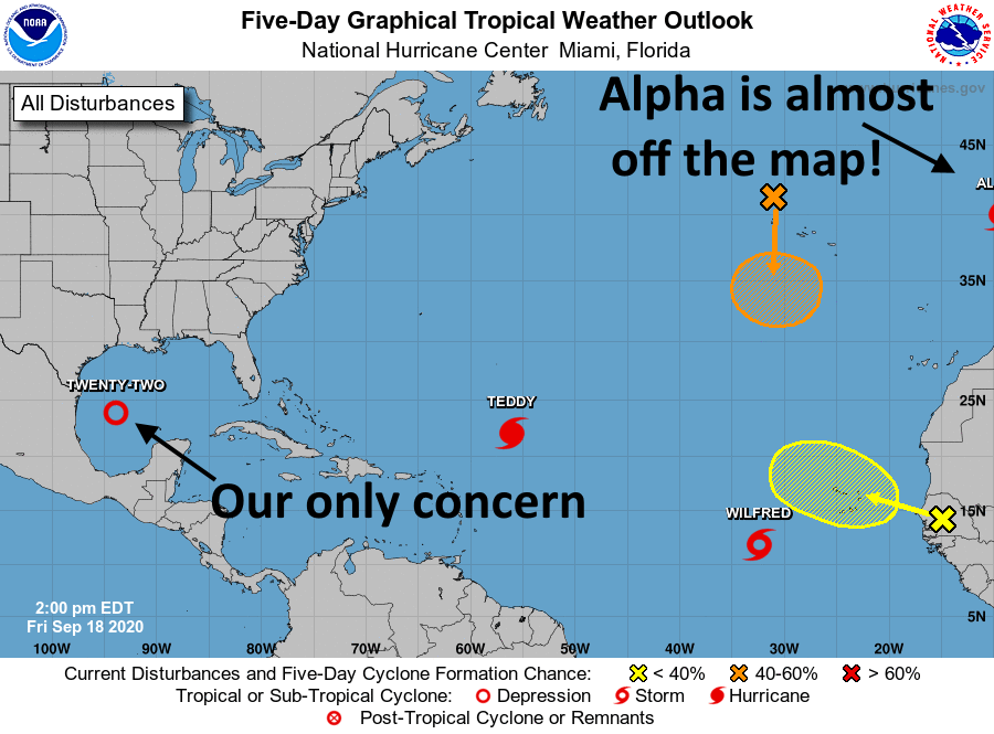
Welcome to another crazy day in the tropics. While we we’ve been waiting for Tropical Depression 22 to strengthen into a tropical storm, a system in the deep tropics became Wilfred this morning. And then, at noon, Subtropical Storm Alpha improbably formed off the coast of Portugal. Neither of these storms remotely concern the Gulf of Mexico, so our focus will remain on the depression that will become—checks notes—Tropical Storm Beta later today.
The state of the tropics at 1pm CT Friday. (National Hurricane Center)
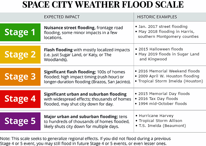
We are issuing our first Flood Scale forecast for this depression, with the caveat that this is subject to change. Simply put, there remains a healthy amount of uncertainty about where the heaviest rains will come over the next five or six days. However, for now, we are calling for a Stage 2 flood for areas south of Interstate 10, and a Stage 1 flood for areas north of Interstate 10. The biggest rainfall risks for Texas are right along the coast, from Brownsville to Galveston.
Space City Weather Flood Scale
Now let’s talk track, because that ultimately will determine what happens with the depression’s rainfall.
Where will Beta bend?
This will be the story of two turns. The following graphic shows the National Hurricane Center’s official forecast track (as of 10am CT Friday) in black. I’ve made several annotations that I want to talk through to help you understand the track forecast and the uncertainties that we’re dealing with.
Click to enlarge. (National Hurricane Center/Space City Weather)
Alright, so we’re fairly confident in the storm’s track today and tomorrow, when it should run into high pressure associated with the front that has moved through Houston already. This should push the system westward, toward Texas. The big question after this is how far west the storm will get—probably very close to the coast, and perhaps even a little bit inland (I’ve tried to highlight this area with the white rectangle). The storm does its coast-hugging, slow moving routine on Monday. At this time it will produce a lot of rain, but hopefully most of this will fall east of the center, offshore.
The second turn
By around Tuesday, the storm should begin to lift to the north and then northeast, perhaps moving close to the coast (as indicated by the official forecast), or further inland (wetter for Texas) or further offshore (drier). Because we have so little confidence in the track for Tuesday and beyond it’s hard to say how much rainfall we will see in the Houston region. For example, I could envision 5 inches of rain in Galveston, or 20 inches. I could envision 2 inches of rain in Houston, or 8 inches. We’re pretty confident that rain chances will perk up on Sunday, with the really heavy stuff possible from Monday through perhaps Thursday morning. For more precise totals you’re going to have to hang in there with us until we get a better handle on the storm’s track.
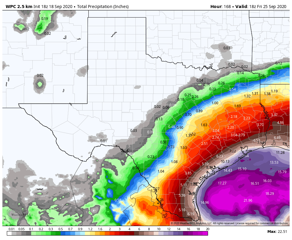
NOAA forecast for total precipitation between now and midday Friday. (Weather Bell)
Coastal flooding
The other issue is coastal flooding. Generally, we anticipate the potential for water levels to rise 1 to 2 feet higher than the region experienced with Hurricane Laura three weeks ago. Waters will start to rise on Saturday, and increase on Sunday. After that any additional rises will depend upon the intensity of the depression—we still think it’s going to become a tropical storm or a Category 1 hurricane at most—and its track. So these hazards are to be determined as well.
That’s all we have for now. Matt will have our next update at 8:30pm CT this evening. By that time Beta probably will have formed. Alas, Beta won’t be a fish storm.
We will hop right into things today, beginning with our near-term forecast and then jumping into the latest on Tropical Depression 22.
Friday & Saturday
The cold front is through, and we’re on the way to more comfortable weather. Look for a good bit of cloud cover at times today, with perhaps a slight lean toward more sunshine later in the day. Highs should be in the upper-80s today, perhaps a bit cooler in spots, and you’ll notice a bit less humidity as the day wears on.
Clearing commences tonight, and we’ll have a stellar morning Saturday, with lows mostly in the 60s.Look for full sunshine tomorrow in most of the area with highs again in the upper 80s and tolerable humidity, a very nice late summer day. Winds will be noticeable at 10 to 15 mph, with some higher gusts up closer to 20 mph at times, especially on Saturday.
Sunday & beyond: The TD 22 impact
Alright, let’s talk about Tropical Depression 22. We’ll start with what it’s doing now, and then we’ll run through some track scenarios and what impacts those have for the Houston/Galveston areas south to Matagorda.
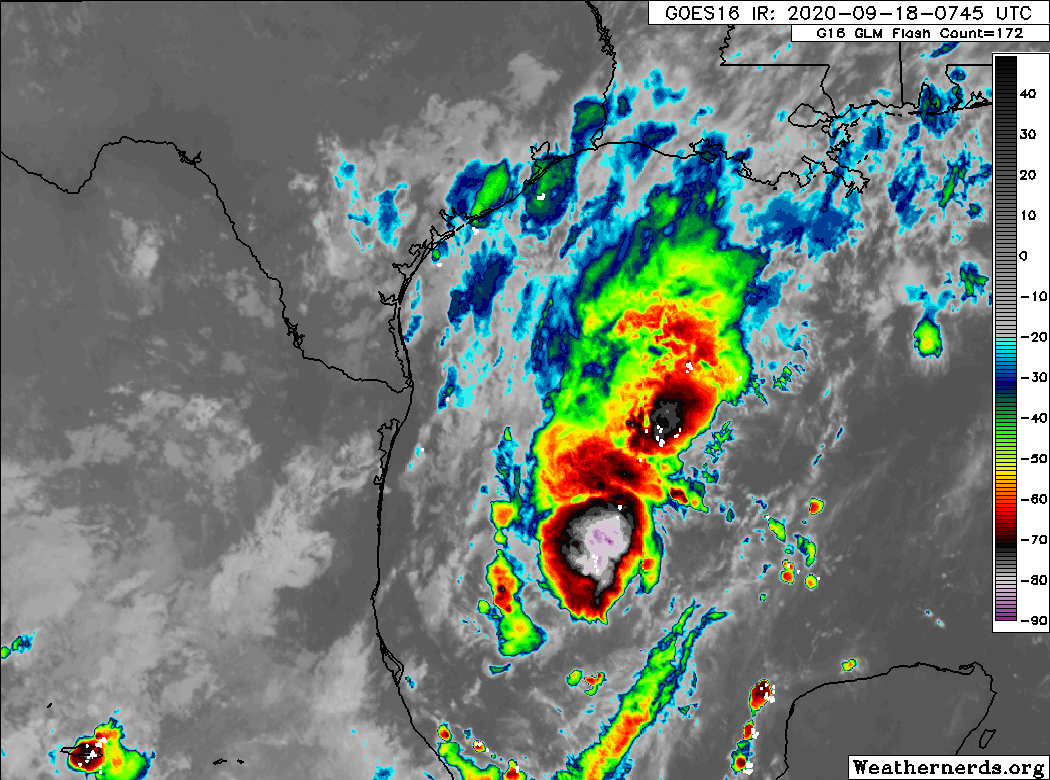
Tropical Depression 22 has a formidable area of thunderstorms, but it is not strengthening particularly fast at this time. It will likely become a tropical storm later today. (Weathernerds.org)
If you look at the satellite loop above, you’ll see that while TD22 certainly has a lot of thunderstorm activity, it lacks a lot of organization. Per the National Hurricane Center (NHC), the center of TD22 is fairly elongated and its motion erratic. Basically, this is still a nascent storm.
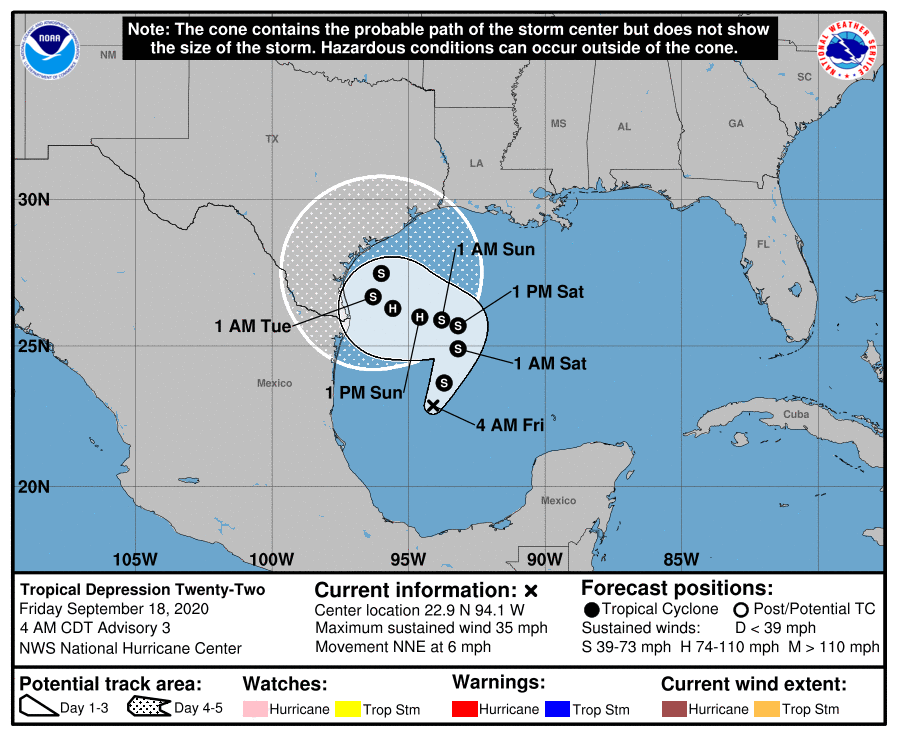
Over the next 48 hours, the storm will, broadly, track slowly to the north or north-northeast. The center, which is currently about 250 miles east of the coast of Mexico will likely end up about 250 miles off the coast of Corpus Christi by Sunday morning. We have fairly good confidence in this part of the forecast.
The official NHC forecast for TD 22 has it beginning to turn back toward the coast late Saturday and Sunday, before confidence plunges on exactly what it will do. (NOAA)
From there, forecast confidence plummets. But we can again at least make some generalizations. The storm should generally, slowly track toward the coast south of Houston on Sunday, Monday, and Tuesday. The NHC brings it up to category 1 hurricane intensity on Sunday and Monday, but even they admit that is at the “top end” of forecast guidance at this time. Assuming it’s Tropical Storm or Hurricane Beta, it will likely begin to weaken after Monday thanks to dry air from our recent cold front being wrapped into the storm.
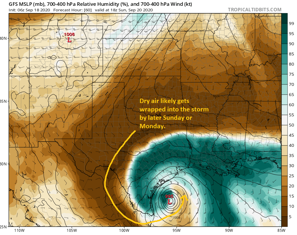
The GFS model here shows dry air (in brown) being wrapped into the storm on Sunday and Monday. This should “cap” intensity and may lead to slow weakening. (Tropical Tidbits)
While we should remain vigilant for any sudden changes in intensification, Eric and I (and most others) will be framing TD22/Beta in terms of a water concern more than wind. This is not Laura. With the storm possibly stalling off Corpus Christi for a time, coastal areas south of Freeport may end up seeing lower-end tropical storm winds for a couple days.
Because this is a slow-moving rainstorm, there will also be temptation to compare it to a certain 2017 storm. This is not Harvey. I don’t want to give people a false sense of security; this storm is a serious concern in its own right, but it is a unique storm that will pose different problems for different places than we saw in other past storms.
TD22 or Beta will likely stall off Corpus for a couple days and then begin to drift northeast out of the area. That process may take a couple days itself, and it’s possible we are not done with this storm until next Wednesday or even Thursday.
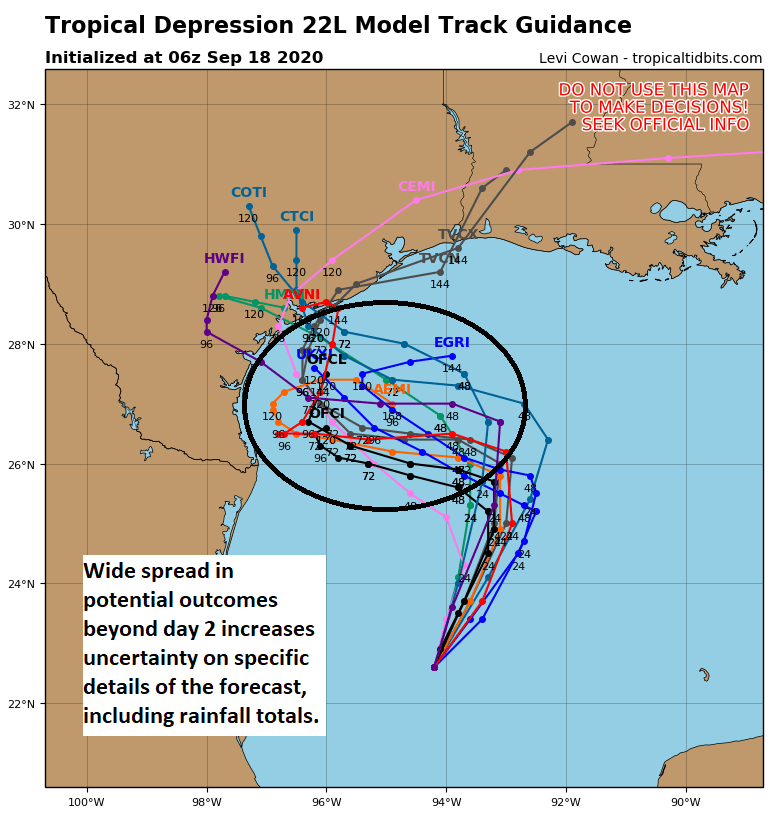
Just to give you a sense of why there’s still uncertainty, here’s a look at the tropical “spaghetti” plot.
The wide spread in individual model outcomes beyond day 2 of the forecast is the basis for the uncertainty, specifically in terms of the rainfall forecast. (Tropical Tidbits)
Don’t focus on any individual track here, but the reality is that a number of possibilities exist, each of which could offer a different outcome for the Texas coast. A track to the west approaching the coast near Brownsville will provide a different rainfall outcome than one that comes west closer to Matagorda Bay. And that’s why it’s important to understand that the specific details of this forecast are absolutely subject to potentially considerable change over the next few days.
So what about rainfall? Well, the current forecast is based on the official NHC track. As noted, this can and probably will change for better or worse.
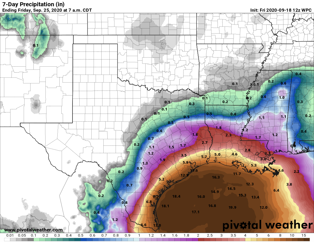
Rain totals will be significant at the coast and likely drop off inland, potentially dramatically. The gradient between lower rainfall totals and problematic ones will be small, meaning there may be considerable differences in impacts over small distances. (Pivotal Weather)
The current rain forecast calls for about 2 to 5 inches for most of the Houston area, escalating to 10 to 15 inches as you get toward Galveston or Freeport. Areas north and west of Houston are currently expected to see 1 to 3″ or so. Spread out over a week, this is probably manageable to some degree for areas south and east of Houston. But much will depend on how intense the rain is and for how long, questions we are unable to answer at this time. But this gives you a good opening bid on what to expect. Again, if the track comes farther north or shifts south, these totals will change.
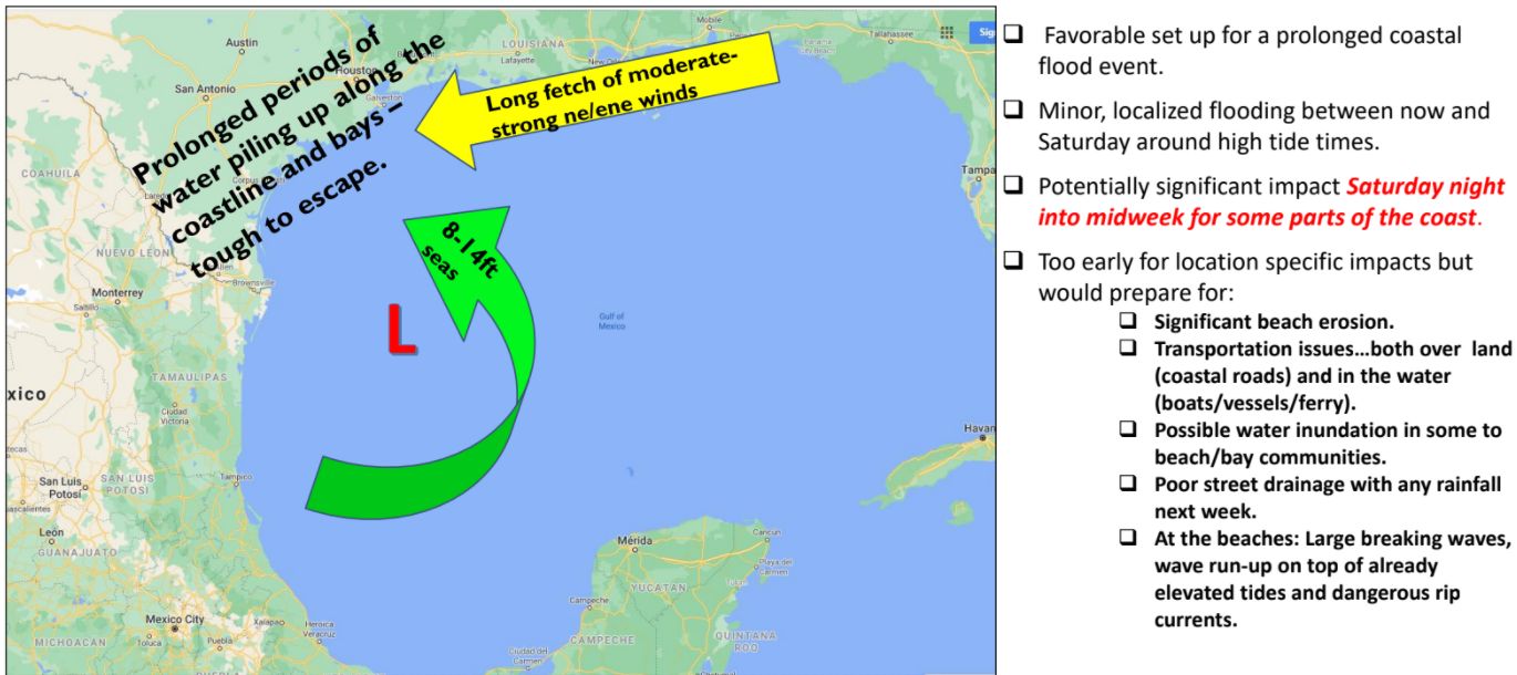
In addition to the rain, there will be some considerable coastal impacts as well. Days of east or northeast winds and 8 to 15 foot offshore seas will pile water up along the coast, with limited chance for it to drain out substantially. The current expectation is for tides to be 1 to 2 feet higher than those experienced during Laura as early as Sunday. This will cause considerable coastal flooding of low lying roads at high tide, as well as significant beach and dune erosion, especially considering it will likely continue into Monday and Tuesday. Coastal residents should be prepared for issues beginning Sunday and continuing through at least Tuesday. We’ll have more on this as it becomes clearer.
It’s a lot to digest, but hopefully we’ve at least given you a reasonable first call at what to expect here. In terms of timing when the rain will be worst and where we will place this on our flood scale, we’ll try and hammer that out a bit more later today and tomorrow. Right now, expect some rain, possibly heavy each day beginning Sunday and continuing into Wednesday.
Eric will have our next update no later than 2pm CT.
Good evening. The National Hurricane Center says a tropical depression has formed in the Gulf of Mexico, and this system may become Tropical Storm Wilfred in the next day or so. Before we get too deep into the forecast I just wanted to highlight a couple of changes from this morning’s post:
The depression is expected to begin moving northward a little sooner than expected, so impacts for Texas could occur sooner
The forecast models are now in a little better agreement that the tropical system will come near, or possibly even ashore the Texas coast, increasing the rainfall threat
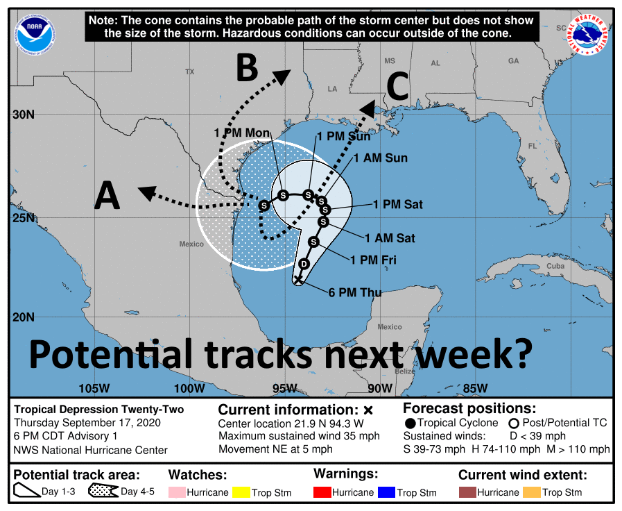
Alright, now let’s jump into the forecast. The 6pm CT “track” prediction from the hurricane center highlights some of our uncertainty when it comes to the depression. After the storm moves slowly north on Friday and Saturday it should run into high pressure building over Texas after the passage of a front. This is what will likely push the system westward, toward Texas.
After Sunday we’re deep into the realm of speculation, as we’re not sure what will happen by Monday or so. The system could plow west or southwest into Southern Texas or Mexico (track “A”) in the map below. It could follow a track up the Texas coast (“B”). It may also essentially stop, and get pulled to the northeast, toward Louisiana, as the high retreats (“C”). We really do not know and anyone who says they do know right now is not being honest with you. Each of these tracks would have drastically different outcomes for Houston, which is why our overall confidence in next week’s weather is very low.
The National Hurricane Center anticipates the storm will gradually strengthen and come near hurricane strength by Sunday. While the Southern Gulf of Mexico is fairly warm—plenty so for strengthening—the storm will likely take on dry air from the north which will not help its organization. Moreover, a slow-moving system will churn up cooler water from deeper in the Gulf. Bottom line: While we’re always concerned about September storms intensifying in the Gulf, in this case we’re more concerned about the moisture from this system than winds.
Any number of possibilities are open with the depression’s track next week. (National Hurricane Center)
As we’ve been saying, the depression has the potential to become a prodigious rainmaker over the next week for Texas and northern Mexico. We think the cold front and storm’s position will probably keep its heavy rainfall offshore through this weekend, but by Monday or so that may change. It is going to depend how close the storm’s center comes to Texas as most of the heavy rainfall should be near the center, and on the eastern half of its circulation.
Because of the track uncertainty, the entire Texas and Louisiana coasts need to be paying close attention to the potential for heavy rainfall next week. We don’t have to tell you about the potential for mischief from slow-moving tropical systems. But with that said, we are still very much in the wait-and-see mode with this system—the greatest likelihood is that the Houston area sees a few inches of rain next week, not a dozen or more.
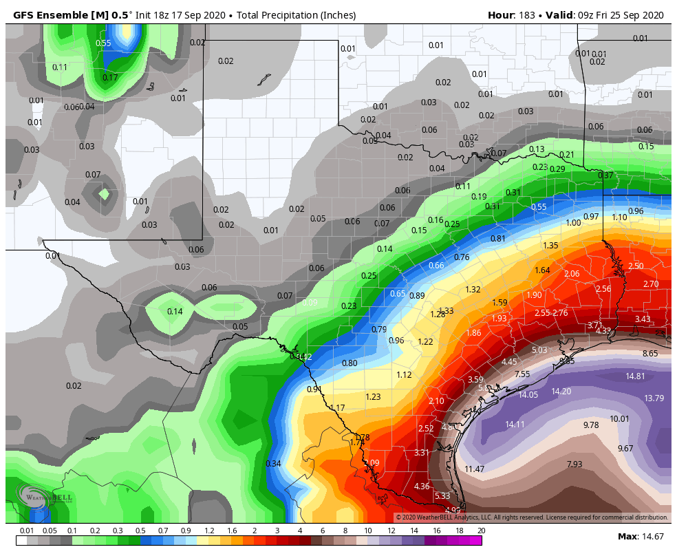
GFS ensemble model forecast for precipitation through Thursday, September 24.
Given that this system is likely to exist for at least the next several days we also have concerns about high tides. Coastal tides are already running about 2 feet above normal, and by this weekend may reach 4 to 5 feet above normal, which will pose problems in low-lying areas along the Gulf of Mexico and Galveston Bay. This is our largest concern after the potential for heavy rainfall.
Matt will have our next update on Friday morning by 7:30am CT.
Good morning. We’re continuing to anticipate the arrival of a cool front late on Friday or Saturday morning, which should make for a rather pleasant early fall weekend across the region. It won’t exactly be cold, but it sure will be less humid. Meanwhile, we’re also anticipating the formation of a tropical storm or depression in the Southern Gulf of Mexico fairly soon—this will have to be watched closely but the forecast for now mostly keeps inclement weather out of the Houston region. More on this below.
Thursday
The really hot weather is almost over, we promise. And it has been hot. Both Hobby Airport and Galveston again tied heat records on Wednesday with highs of 96 degrees. Temperatures should be about 5 degrees cooler today with partly cloudy skies, and rain chances of 30 percent or so. These rain chances will be driven by an upper-level low pressure system and enhanced by daytime heating. Low temperatures tonight will be in the mid-70s for most.
Friday and Friday night
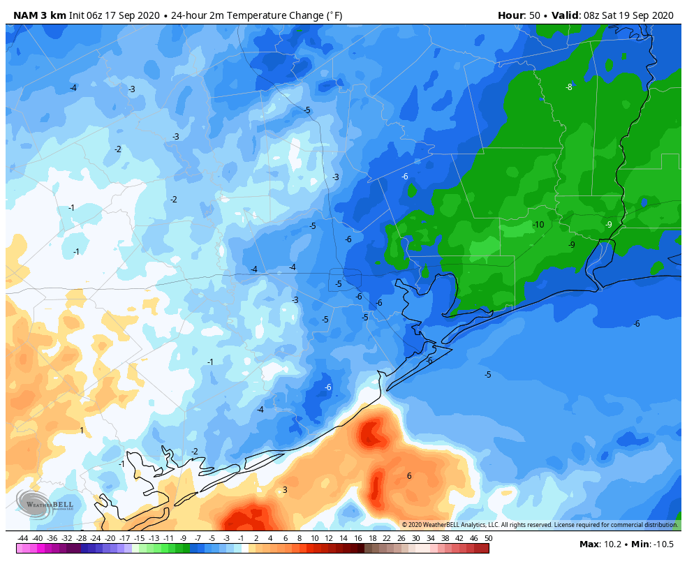
Friday should be similar to Thursday in terms of sensible weather, but things should begin to change late Friday night or Saturday morning. As Matt wrote yesterday, this will not be a knock-you-off-your-feet front blowing in from the northwest, but rather over the weekend we’ll gradually see drier air moving in. This should become noticeable on Saturday morning.
Temperature change forecast for Saturday morning, at 3am CT, shows cooler air moving in. (Weather Bell)
Saturday and Sunday
This will leave us with a pleasant weekend. Right now I’d peg highs in the upper 80s, with mostly sunny skies, for most of us. With lower dewpoints, these temperatures will feel much more comfortable. Low temperatures should get into the mid- to upper-60s on Saturday and Sunday mornings, except for the coast, which will stay a bit warmer. So clearly not cold, but after months and months of summer, the difference in humidity will be notable. Enjoy this taste of fall for a few days Houston, you’ve earned it.