It’s beginning to feel a lot like Christmas—for Houston, at least

Good morning. Houston’s weather will generally remain on the chilly side for the next 7 to 10 days as mid-December feels a lot like mid-December in Houston. This has been a difficult year for many, for many reasons, but at least Mother Nature seems to be doing its part to help us feel like we’re entering the holiday season.

Tuesday

The onshore flow has resumed, with winds blowing out of the southeast at 5 to 10, and as a result we’re going to see mostly cloudy skies today. There should be enough moisture and lift this afternoon to produce widespread, but light showers. I’m expecting most areas to not see more than one- to two-tenths of an inch of rain, primarily during the afternoon hours. A cold front will reach the western parts of the metro area this evening, and likely push off the coast before sunrise on Wednesday morning.
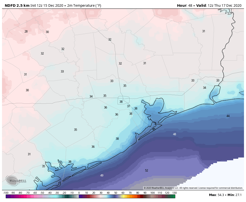
Wednesday

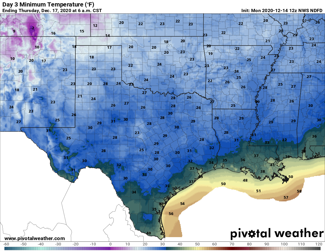
This will be a cold day, with winds from the northwest at 5 to 10 mph. Although skies should clear out during the morning hours to bring us some sunshine, much of the area may not get above 50 degrees. Clear skies and cold air will set the stage for a night that will likely bring a freeze for much of the area outside of the city’s urban core, and away from the coast. Lows in Houston itself will probably drop into the mid-30s.

Low temperature forecast for Thursday morning. (Weather Bell)

Thursday

Another sunny, slightly warmer day as winds become calm. Highs may get into the upper 50s, and lows Thursday night will probably be 5 to 10 degrees warmer than Wednesday night.

Friday and Saturday

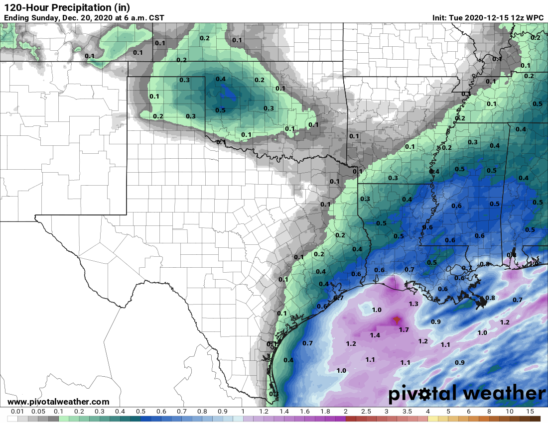
Some clouds begin to return by Friday along with the onshore flow. Because this more moist, southerly flow will have a better chance to get established it will lead to warmer days and, eventually, a better chance of rain. Highs both Friday and Saturday will likely get into the mid- to upper-60s. Rain chances will increase Friday night and into Saturday as a front approaches Houston. I’m still not overly confident in accumulations this weekend, but I’d guess for now that much of the area will see around one-half inch. The next front should push through Saturday afternoon or evening, with clearing afterward.

Sunday

The second half of the weekend looks like a winner for outdoor activity, with light northerly winds, sunny skies, and highs likely in the 60s.

NOAA forecast for total rainfall between now and Sunday morning. (Pivotal Weather)

Next week

We’re still watching the forecast for Christmas Day closely—it’s now just 10 days away! The European model pretty clearly shows a warming trend on Tuesday and Wednesday of next week, and then brings a fairly stout front through on Christmas Eve. This would set the stage for what would probably be a cold and clear Christmas Day. The GFS model seems to be coming around to this scenario as well, but it’s not as set upon it. Bottom line: We are probably looking at seasonal, cold weather for Christmas, but the forecast is far enough out that overall confidence remains low.

Taking an early look at the Christmas forecast

In the wake of an at-times stormy Sunday, and a gusty Sunday night following the passage of a cold front, Houston will experience a winter-like week with days mostly in the 50s and cold nights. Some areas will likely even see a freeze on Wednesday night. Also, we’re now only 11 days away from Christmas Day, so we can also take our first real look at the holiday forecast.

Monday

Some blustery winds remain this morning, but they should generally subside as high pressure moves off to the east. High temperatures today will depend upon the extent to which clouds break down this afternoon. Some areas may reach the low 50s but other parts of the metro area will remain in the 40s. Winds shift to come from the east later today, and nighttime temperatures should drop to around 40 in Houston—cooler inland, and warmer along the coast.

Tuesday

We’ll see more clouds on Tuesday as yet another cold front crosses the area. There will be limited moisture for the front to work with, but it may generate some light showers across the area—I would not expect more than one or two-tenths of an inch of rainfall. Any lingering showers should end by or before sunset on Tuesday, with another chilly night dropping down to around 40 degrees.

Expect a cold morning on Thursday. (Pivotal Weather)

Wednesday and Thursday

The middle of the week will be cool and sunny in the wake of the front. We can expect highs in the 50s to go along with moderate north or northwest winds. Wednesday night will be the coldest of the week, most likely, with a light freeze possible for outlying areas.

Friday, Saturday, and Sunday

Heading into the weekend we should see some clouds mixing into the sky, as temperatures warm a little bit—perhaps into the low 60s? We may see some showers on Friday or Saturday ahead of the region’s next front. At this point they neither look all that strong or severe, but out confidence in this is far from absolute. The next front then pushes through either on Saturday or Saturday night, which likely would yield a cool and clear day on Sunday.

The majority of European model ensemble members suggest a cold Christmas, but it’s far from a slam dunk. (Weather Bell)

Christmas week

It’s hard to believe, but December 25th falls on the Friday of next week. So what kind of weather can we anticipate for Christmas Eve and Christmas Day? The models generally agree that next week will probably be at least a little warmer than this week with its highs in the 50s. The long range models suggest another fairly strong front will push through during the Christmas Eve time frame, just in time for the holiday. I would at this point label this as a strong “maybe,” and if the front does arrive it would make for a fairly cold Christmas. I’d even go so far as to say there’s maybe a 5 percent—that’s a 1-in-20 chance, friends—of some kind of wintry precipitation around that timeframe. But most likely it will just be rain of some sort, with the time and amount to be determined.

Another series of cold fronts heads for Houston, keeping us cool

For those that enjoy Houston-style winter weather, it’s been a treat with a few exceptions over the last few weeks. We’re going to get more of that through next week beginning with the first in a series of fronts later today.

Today

It’s a quiet start this morning with just some clouds around for most. A few sprinkles or showers could develop by late morning. We then expect to see some kind of broken line of showers and storms develop ahead of our first cold front, and press through the Houston area beginning around early afternoon north and west of Houston, and by late afternoon south and east. It appears as though some degree of a “cap” is in place today, which may limit shower and storm development for a time, especially along and south of I-10. However, as the line of showers pushes in, some stronger storms are possible (especially to the north), and the Storm Prediction Center has us in a “marginal” risk of severe weather, the lower-end of the scale.

We are in a marginal risk of severe storms today. The main threat is strong wind gusts, and that’s primarily north of Houston. (NOAA)

We don’t expect widespread severe weather, and it will likely be very much the exception rather than the rule, with gusty winds being the main threat.

Showers should end this evening, with partial clearing tonight. Temperatures will top off in the 70s this afternoon, dropping back into the 50s tonight.

Saturday

Nice weather should be the rule for most of us tomorrow. Expect partly to mostly sunny skies to develop, although clouds may try to linger, especially south and east of the city for a time. But for most folks, we think Saturday looks good. It’ll be a bit cooler with highs generally in the mid or upper-60s, perhaps a bit cooler north and west. Winds don’t look too bad behind tonight’s front, so expect north to northwest winds of 5 to 15 mph or so, though perhaps a touch stronger over Galveston Bay and the Gulf.

Sunday

Front number two will be the story for Sunday. Look for scattered showers and storms beginning as early as Sunday morning. Showers and storms should become more numerous through the day, ending around evening. This would be especially true south or east of Highway 59/I-69 we think. Not that areas north and west won’t see rain, but it looks a little less impressive there than to the east. It now appears that Sunday’s front may be the more aggressive one over our area, so if you’re looking to do something outdoors, Saturday is your day.

Total rainfall between both fronts this weekend will be around 0.5-1″ area-wide, perhaps less in some areas south & west and more in some areas north & east. (NOAA forecast via WeatherBell)

Total rainfall from the two fronts this weekend will likely add up to about a half-inch to an inch in most of the area. Some locations south and west of Houston may see a bit less and others north and east perhaps a bit more.

Sunday’s temperatures will start in the 50s and peak in the 60s or low-70s. Look for winds to pick up Sunday night to 10 to 20 mph out of the north, with gusts up to 30 to 35 mph over the bays and Gulf.

Monday and Tuesday

Clouds may linger into Monday behind Sunday’s front, giving it a real wintry feel. We will start with lows in the low-40s. Expect highs in the 50s with gradual clearing. If clouds do not clear by Monday afternoon, however, it’s possible we do not see high temperatures get to 50 degrees in spots. Chilly!

Tuesday looks great, however. Look for skies to become mostly sunny with a cool start. We’ll warm from the low or mid-40s into the low or mid-60s.

Wednesday and beyond

A third cold front is likely to push through the region Tuesday night or early Wednesday, ushering in another shot of cool, dry air. This one will lack moisture, so we don’t expect rain. We will see lows on Wednesday and Thursday mornings in the 30s or low-40s. Freezing conditions seem unlikely at this time. High temperatures will only get into the 50s Wednesday and maybe 60-ish on Thursday as it stands right now.

There are signs that perhaps a more aggressive and longer-lasting warming trend may develop by next weekend.That being said, the handful of times we’ve seen this over the last month or so, a cold front has magically appeared within those periods, shortening the warming to just a couple days. Will that happen again this time? More for you on Monday!

Storms possible Friday before two fronts return winter to Houston

Good morning. As we get closer to the weekend our forecast is coming into slightly better focus, but we still have some questions about the timing and intensity of some storms that may roll through on Friday, and potentially again on Sunday. Let’s jump in.

Thursday

The big change for today will be winds, which will become more pronounced from the south during the daytime. Even though moisture levels will increase some, I still think our skies will remain mostly sunny. This will allow temperatures to climb into the upper 70s. Southerly winds will continue overnight, pumping more moisture into the area. Lows likely will not fall below 60 for most of the area.

Friday

An upper-level system will approach Houston on Friday, and combine with this moisture to produce widespread showers and perhaps a few severe thunderstorms. The primary threat will come from strong wind gusts. I think the afternoon hours will be the most likely period for rainfall, and expect most of the region to see 0.25 to 0.75 inches through Friday evening. Rains should end by Friday night as a cool front nears the area.

Rain accumulation forecast for now through Friday night. (Pivotal Weather)

Saturday

This front should reach Houston during the morning hours, and move off the coast by or before noon. At this point it looks like Saturday will turn out to be a rather nice day, with highs perhaps reaching near 70 degrees, and plenty of sunshine during the afternoon to go along with light northerly winds. Lows Saturday night will likely drop to around 50 degrees in the city.

Sunday

Another upper level feature will approach Houston on Sunday, and this could drive another round of rain chances during the daytime. The global models are not in great agreement on rain totals with this second system, but for now I’d expect less rain than the region will see on Friday. Matt will have to get the scoop for you in tomorrow’s post. Highs Sunday will likely get into the 60s, with partly sunny skies. A stronger push of cold, dry air arrives later Sunday, or Sunday night, setting the stage for cooler conditions.

Houston should see winter-like conditions for much of next week. (Weather Bell)

Next week

I expect the cooler and drier weather—highs in the 50s and 60s, lows perhaps around 40 degrees—to hang around for much of next week, with a warming trend only kicking in perhaps by next Thursday or Friday. Winter is coming (back)!