Gusty winds around the region today before a pleasant weekend

Good morning, and happy Friday. It’s a cool start to the day today, as we’re in the wake of a cold front that moved through last evening. We’ll have a round of gusty winds today before things settle down for the weekend.

Today & tonight

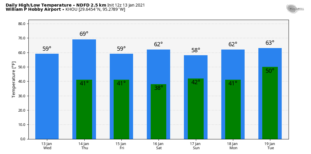
Today is starting off calm enough with clear skies, cool temperatures, and generally light winds. The clear skies and generally cool temperatures will stay with us today, with highs in the 50s. But the wind? That will begin to howl in just a few hours. We expect wind gusts of 25 to 35 mph area wide today, with some higher gusts possible in northern stretches of the region.

Wind gusts could exceed 30 to 35 mph in a few spots north of Houston later today. (NWS Houston)

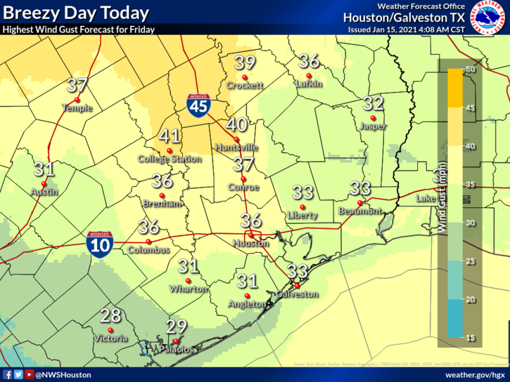
A wind advisory is posted for late morning and early to mid-afternoon. With high winds and low humidity, it’s a higher than usual brush/grass fire danger day today. Relative humidity could drop below 20 percent at times, a very dry day.

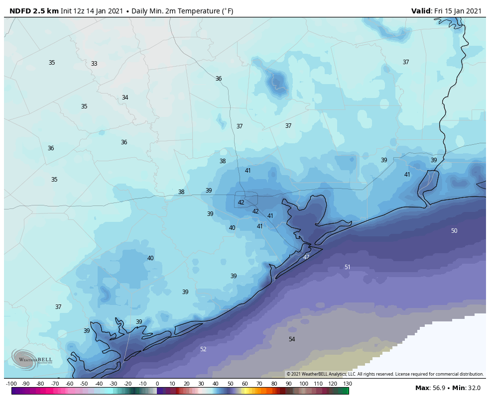
Winds will quickly settle down around and just after sunset, and they should be back to relatively calm conditions tonight, with lows near freezing north and west of Houston.

Lighter winds and clear skies may allow temperatures to drop to near freezing north and west of Houston tonight, with mostly 30s elsewhere. (NOAA forecast via Weather Bell)

Look for 30s elsewhere, with near 40 at the coast, a chilly night.

Saturday through Monday

After today, fair, quiet weather will be the story through Monday. Look for sunny conditions with just a few clouds on Sunday and Monday. Temperatures will slowly warm through the period, topping off in the upper-50s on Saturday, low-60s on Sunday, and mid-60s on Monday. Morning lows will stay cool, with 30s to near 40° on Sunday morning and mostly 40s on Monday morning. Winds will stay light but could pick up a bit on Monday afternoon as onshore flow redevelops.

Tuesday and beyond

A pretty messy weather pattern is expected Tuesday through Thursday or even Friday before a cold front finally clears everything out. Onshore flow will transport really humid air back into the region Tuesday and Wednesday, likely leading to scattered showers. The problem in this period is that details around the forecast continue to fluctuate both in terms of how much rain we see and where it falls. We know that the potential will exist for heavy rain and at least some thunderstorms. But we don’t know if it’s more a story for our area, farther north toward Shreveport, LA, or for all of eastern Texas and western Louisiana. We will have a full update on this for you Sunday or (more likely) Monday.

Lovely weather for Houston to close out the week

Good morning! Matt here, in for Eric who is getting in a light jog this morning.

Good luck to him, as he runs the virtual Houston Marathon! Best of luck to all our readers that will be participating as well (and congratulations to those that have already wrapped it up). We’ve got some very nice weather yet to come.

Today and tonight

We should see ample sunshine through the day today, with just a little patchy fog in spots dissipating this morning. The cold front mentioned above will push through the area probably around late afternoon or early evening. I don’t think you’re going to notice much more than a wind shift and some clouds as it passes. Winds may get a little gusty in the wake of the front. Look for highs today in the 60s, possibly well into the 60s in spots.

Tonight sees clear skies and breezy conditions with a northerly wind gusting up to 20-25 mph at the coast.

Tomorrow morning will be another chilly one with 30s and 40s area-wide. (NOAA via Weather Bell)

Temperatures will again be chilly, with lows near 40 degrees or in the 30s north and west of Houston to mid-40s in the city and near the coast.

Friday through Sunday

Basically, the entire weekend looks sunny right now. There could be some lingering gusty winds on Friday, especially near the coast and Galveston Bay and a few high clouds on Sunday, but other than that, it will be blue and beautiful. Highs will range from the upper-50s to low-60s with lows in the 30s and 40s. About as nice as you could ask for in winter in Houston.

Monday and Tuesday

We would expect Monday to be an extension of the weekend with a good deal of sunshine. Temperature should increase somewhat, however, with highs in the mid-60s after morning lows in the 40s. Tuesday will see clouds begin to increase as we begin to get stronger onshore flow and warmer temperatures. Look for fog, clouds, haze, or showers and highs perhaps pushing 70 degrees after a morning in the 50s.

Midweek next week

Tuesday’s onshore flow and increasing clouds heralds our next cold front. Look for that to cross around Thursday, give or take a day. Ahead of the front: Scattered showers and thunderstorms, some perhaps heavy.

Rainfall expected through Thursday morning next week is 1 to 2 inches area-wide, with perhaps a little more after the period. (NOAA via Weather Bell)

The early indications point to about an inch or two of total rain from the showers and storms that will come ahead of and with Thursday’s front. But there’s a good deal of uncertainty on specifics in this timeframe, so watch for some changes as we get closer.


Some areas of Houston saw graupel Tuesday, a rare form of winter precipitation

Good morning. Some readers reported seeing a bit of freezing precipitation on Tuesday. This was due to an upper level disturbance that moved in rapidly from the west. Because the atmosphere was very dry, it was not expected that this precipitation would make it all the way to the ground, but some of it did. What you saw, in most cases, was graupel. What the heck is graupel? It is similar to, but distinct from sleet. Here’s a graphic that shows how it forms in the atmosphere. Essentially, supercooled water droplets form on falling snowflakes in a thin layer of warmer atmosphere.

How different types of winter precipitation form. (National Weather Service)

Wednesday

We’re done with the wintry mix and precipitation chances for now. After a cold start, with temperatures dropping into the 30s across much of the area except for the coast, Houston should warm nicely today. Under sunny skies, we expect highs to reach about 60 degrees. Winds will be light, out of the west to southwest. Low temperatures tonight should reach about 40 degrees in the city of Houston. For the record, I’m choosing to run the Houston virtual marathon early on Thursday morning, which may give you an idea of my preferred weather conditions for long runs. In any case, Matt will be covering things on Thursday for Space City Weather as I’ll be knackered.

Thursday

After another chilly start, this will be the warmest day of the week. Look for highs to reach the upper 60s to possibly 70 degrees for some areas, with mostly sunny skies. Just as things are warming up, a cold front will push through on Thursday evening, bringing a wind shift from the north. The atmosphere will be dry enough that we don’t envision any precipitation with the front. Lows will probably drop down to around 40 degrees.

Houston’s forecast: Lots of days with highs around 60, and lows around 40. (Weather Bell)

Friday

In the wake of the front, Friday will be breezy and cool. Winds out of the north will blow at about 10 to 15 mph. Look for highs in the upper 50s to 60 degrees, with mostly sunny skies. Winds will die down during the afternoon or evening hours.

Saturday

The first half of the weekend looks splendid. The day with start out in the upper 30s to 40 degrees, and with mostly sunny skies highs should reach into the low 60s.

Sunday

On Sunday we can’t rule out the possibility of some rain showers due to some atmospheric instability. However, I think chances, on the whole, are fairly low—likely 20 percent or less. Skies otherwise should be partly sunny, with highs near 60 degrees.

Next week

For Monday—M.L.K. Day—we should see the return of mostly sunny skies and highs in the low 60s. The forecast turns a bit more sour on Tuesday and Wednesday, as it looks like several ingredients will come together to bring healthy rain chances. It’s too early to have confidence in totals, but a general expectation for now is 0.5 to 1.0 inch of rain.

Sunny, serene weather comes to Houston through Saturday

Good morning! We’re getting past the coldest weather of the week this morning, but it’s not exactly going to warm up dramatically any time soon. Looking ahead for the next 10 to 14 days, much of the region may not see highs above the mid-60s as Houston goes through what is climatologically the coldest time of the year.

Tuesday

A light freeze has fallen across much of the area this morning, although the urban core of Houston appears likely to remain at or just above freezing. Yesterday was quite cold. My personal weather station recorded highs briefly reaching 45 degrees during the afternoon. Today will be slightly warmer, with partly sunny skies allowing for temperatures to reach around 50 degrees. Winds will be light, out of the north at about 5 mph. Lows tonight should be about 5 degrees warmer than Monday night.

Expect another chilly day in Houston on Tuesday. (Weather Bell)

Wednesday and Thursday

High pressure will keep conditions on the sunny side for the middle of the week. Highs on Wednesday should reach about 60 degrees, and then Thursday looks to be the warmest day of the week as highs reach into the mid- or possibly upper-60s. Meanwhile, nights should see temperatures drop to around 40 degrees.

Friday and Saturday

A reinforcing front will arrive Thursday night. Since our atmosphere will be sufficiently dry, we likely won’t see any rain with this front. However, it will keep things on the cooler side, driving high temperatures back to around 60 degrees, with sunny skies on both Friday and Saturday.

Houston should see a solid block of sunshine from Wednesday through Saturday. (Weather Bell)

Sunday and beyond

Sunday morning will start out cold, likely in the low 40s. But after this the models begin to diverge in how they handle an upper-level feature in the atmosphere that could potentially spark some rainfall. We have a couple of unanswered questions at this point: How close will this trough get to Houston, and how moist will the atmosphere be by Sunday? The bottom line is that after several sunny days, we could see the return of some clouds Sunday, and possibly some light rain showers later in the day.

By Monday, M.L.K. Day, we hope to see mostly sunny skies. However, next Tuesday and Wednesday may also generate some scattered to widespread showers across the region. The bottom line is that we’re pretty confident in the forecast through this Saturday, and the after that the picture becomes a bit more fuzzy.