More very cold weather coming—power sure would be nice

This week Houston has survived a freakish snow and ice storm, extreme cold, and bout of freezing rain. So what else does Old Man Winter have to throw our way? Well, my friends, there is just one last sting in the tail, then it looks like this mess will be over.

At least from the standpoint of weather—in terms of electricity and water, that is another issue entirely. As of this evening, about 2.3 million Texas homes and businesses remain without power, and about half of those are in the greater Houston area. For millions of your neighbors, the misery continues.

Wednesday night

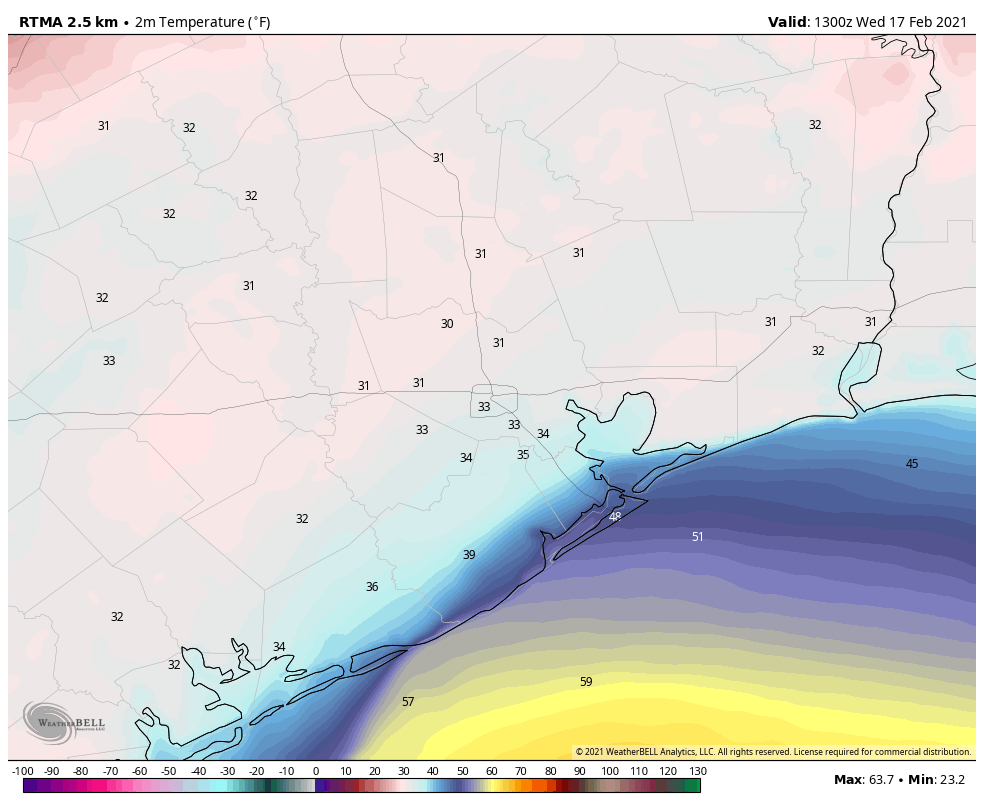
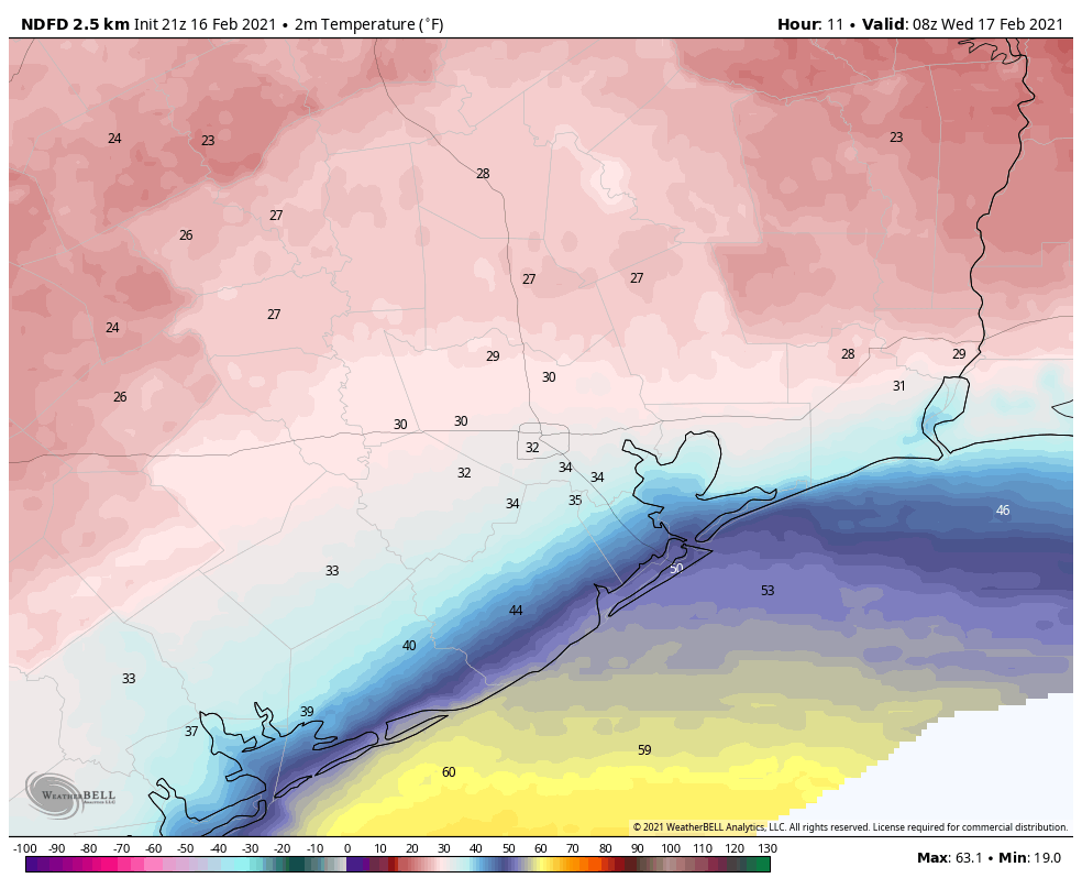
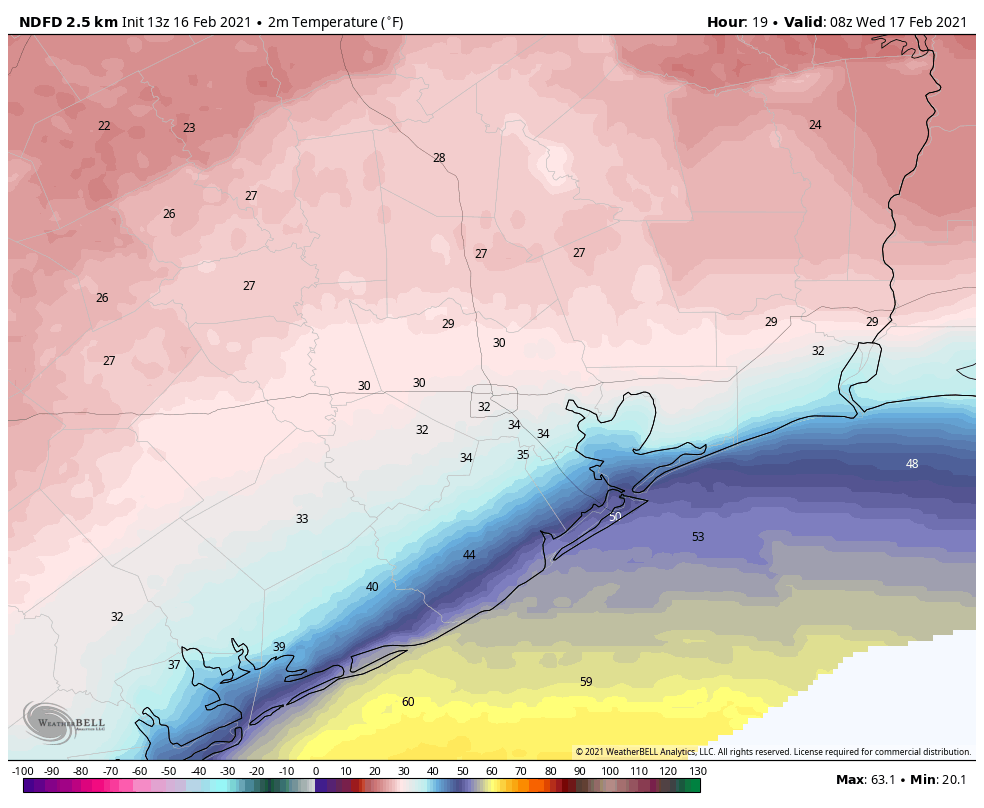
In the wake of precipitation earlier today, cold air from yet another front is now moving into the Houston area. Temperatures will drop to freezing levels north of Interstate 10 tonight, and where ice or water remained on roads today, this will refreeze tonight. There is also the possibility of some light snow or sleet late tonight north of Interstate 10. In these areas you’ll need to watch for icy spots on roads through about noon on Thursday. Closer to the coast, a freeze is unlikely overnight.

Thursday and Thursday night

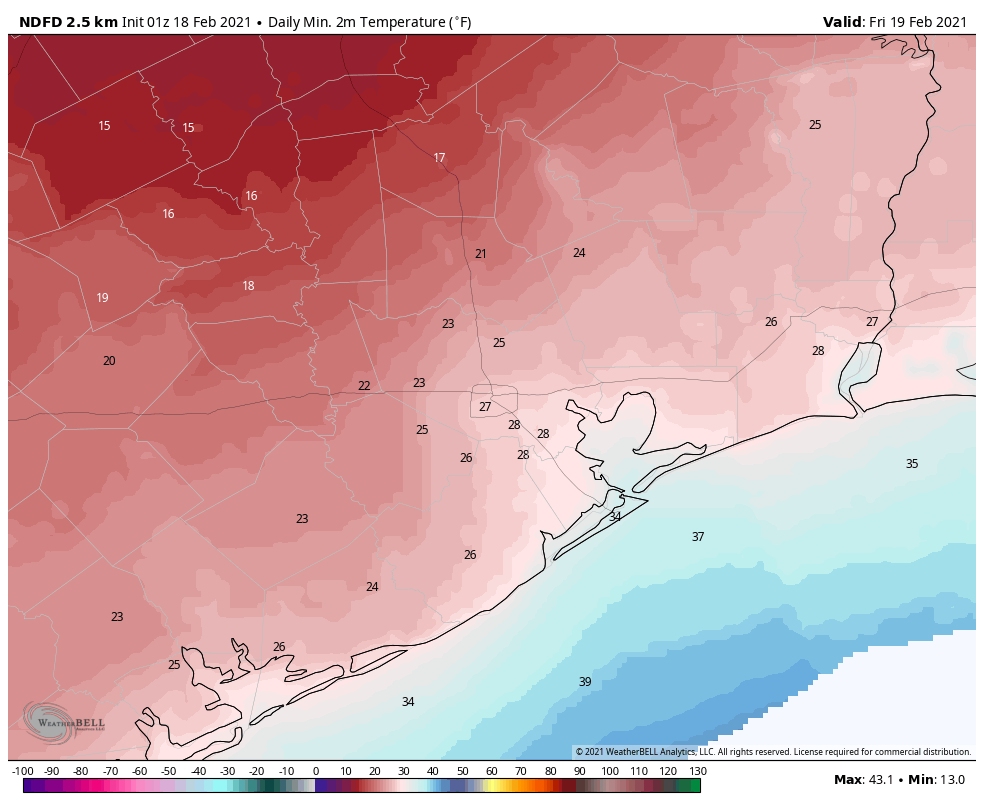
High temperatures on Thursday should get into the mid- to upper-30s. Brisk winds out of the north will knock wind chill temperatures below freezing. But at least we should be dry after lots of wintry precipitation. After a cloudy start, a bit of sunshine may peek out later in the afternoon on Thursday. This will be nice, but clearing skies also means we’ll see strong radiational cooling on Thursday night, with lows again dropping into the 20s on Thursday night.

It. damn. sure. would. be. nice. to. have. power. back. by. then. ERCOT.

Thursday night will be very cold. Friday night will, too. (Weather Bell)

Friday and beyond

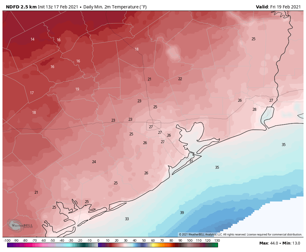
After a cold start, sunshine should help temperatures warm into the low 40s on Friday, but with a northerly wind it will feel cold out all day. Low temperatures on Friday night will still be very cold, but should be a couple of degrees warmer than Thursday night.

Highs on Saturday should push into the 50s, and the threat of a freeze will finally be over.

Freezing rain falling across northern Houston, millions still without power

Good morning. The Houston area is now on day three of a miserable stretch of weather that has been magnified by widespread and ongoing power outages that seemingly have no end. Of the weather, we can at least say this, Houston is closer to the end of this Arctic blast than the beginning.

The freezing line at sunrise runs roughly along Interstate 10 this morning. (Weather Bell)

Wednesday

Generally light precipitation is falling across the metro area, and as anticipated this is simply rainfall south of the freezing line, and freezing rain to the north. Right now this line stretches roughly from Columbus to Katy to Cypress to Kingwood. This freezing line should lift slowly north to the northern edge of Harris County by around mid-morning, and to Highway 105 by around noon. (Here’s a list of current icy road conditions). Most of the region should be passable by noon as temperatures warm, but motorists along and north of Interstate 10 should take care on roads, especially bridges and elevated highways, until ice has melted.

Precipitation will begin to exit the area to the east by noon or shortly thereafter, leaving a cold and gray day in its wake. High temperatures today will generally reach about 40 degrees south of Interstate 10, and mid- to upper-30s north of the freeway. However, for inland areas—again, north of Interstate 10—temperatures will begin to approach freezing levels by around sunset or within a few hours after this. Depending on the extent to which roadways dried, any lingering water may freeze, and travel may remain treacherous in some locations. Lows will drop into the upper 20s for inland areas, and remain at or just above freezing closer to the coast.

Thursday night and Friday morning will be the last very cold conditions of the week. (Weather Bell)

Thursday

As additional cold air surges into the area on Wednesday night—and this is the final push of very cold air—we’ll see one more slight chance of precipitation in the form of snow or sleet during the morning hours. However, this is generally expected to be slight, and not pose additional problems on roadways. Highs should reach into the mid- to upper-30s on Thursday, with one more very cold night. Lows will drop into the 20s for much of the region.

Friday, Saturday, and Sunday

The weekend will see stair-stepping high temperatures of 40s on Friday, 50s on Saturday and 60s on Sunday. There will be plenty of sunshine. Houston is unlikely to see a freeze again this winter after Saturday morning, but after what we’ve been through this week I am making no guarantees.

Power outages

The catastrophic power outage continues across much of Texas, with 2.8 million customers still without power statewide as of 7:30 am Wednesday morning. This is down from 4.4 million on Tuesday morning, but about half of those losses are within the Houston metro area. State officials who manage the electric grid at the Electric Reliability Council of Texas have not been able to provide any reliable information about when power may be restored to all. This really is unacceptable in weather conditions such as these.

Houston warms somewhat, but dangerous ice storm looms overnight

Much of the Houston area has warmed to at or above-freezing levels today, but just as the region can start to take a breath, Mother Nature is readying a second punch. It will come tonight in the form of another round of precipitation, which will fall as freezing rain for inland areas.

Tuesday night

Road conditions have been improving today, and should remain so until later evening, or possibly even midnight. After this point precipitation from a coastal low pressure system will begin overspreading the area. The key question is where the freezing line falls, north of which will produce freezing rainfall. Initially, this line will likely fall roughly along Interstate 10, and then may migrate northward as temperatures warm Wednesday morning. The big concern this presents is accumulating freezing rain on roads and power lines, especially north of Highway 105.

The freezing line will set up near Interstate 10 tonight. (Weather Bell)

The bottom line: Travel in the northern half of Harris County, and points north, could become problematic to rather dangerous late this evening, and should be avoided after about 10pm.

Wednesday

The precipitation will come to an end by around noon on Wednesday, and then it becomes a game of when air temperatures will warm enough to melt off any ice on roadways. For now I think that will occur before noon in Harris County, and probably after noon in Montgomery County. There likely will be some point around Highway 105, or north, where it does not get warm enough to burn through the ice. Where that will be? Can’t say for sure right now.

In Houston itself, expect highs to reach the upper 30s, with lows dropping just below freezing Wednesday night. Some additional light precipitation is possible Wednesday night, but at this point is not expected to cause major additional problems.

Thursday and beyond

Thursday looks cloudy and cool, with highs in the upper 30s to 40 degrees. But the rain will be over. Thursday night will provide one more sting, with lows dropping into the 20s. After this we’ll be off to the races in terms of sunshine and warming. We should see mostly sunny skies into early next week.

We’ll have a comprehensive update for you in the morning. Please stay safe, and as warm as these trying conditions permit.

After this morning’s extreme cold, freezing rain returns tonight

Good morning. Temperatures are bottoming out at 10 to 15 degrees across much of the metro area in what will be the region’s coldest night in more than three decades. The city’s official low temperature, measured at Bush Intercontinental Airport, looks to be 12 degrees.

Making matters worse today, power outages persist across the state, with more than 4.1 million customers without power. Many of these power outages are concentrated in and around the Houston area. Weather conditions will begin to slowly improve today, but there are no reliable estimates for when widespread power will be restored. We discussed why in a post on Monday.

Your 7 am CT temperatures across Texas on Tuesday morning. (Weather Bell)

Tuesday

Clearing skies and winds shifting to come from the east later today will help warm temperatures somewhat. Most areas south of Interstate 10 should reach above freezing later today, but road conditions are iffy this morning. Some streets dried out with Monday’s sunshine, but roads and bridges that remained wet iced over again on Monday night. Sunshine later this morning should help with most roadways later today.

However, precipitation will return this evening and overnight as moisture moves in from the Gulf of Mexico. Most likely the precipitation will begin around midnight, but we can’t rule out it starting earlier. For Houston, it should begin as rain, but could transition to freezing rain over night. North of a line from Matagorda to Houston to Winnie, we can probably expect temperatures to freeze tonight. Galveston and Brazoria counties, for the most part, are unlikely to rain transition to freezing rain as they will remain above 32 degrees.

Bottom line: Travel Tuesday evening and overnight in Houston and could be very problematic due to icy roads. For Montgomery County and points north accumulating freezing could be exceedingly dangerous, and pose problems for power lines.

The coastal tier of counties will likely escape a freeze on Tuesday night. (Weather Bell)

Wednesday

By mid-morning Wednesday, or shortly thereafter, temperatures should rise above freezing across nearly all of the metro area, and this should melt ice. Highs in Houston will reach about 40 degrees, if not a touch warmer. Some additional sleet or light snow is possible Wednesday night, but this seems unlikely to be too problematic. Areas south of Interstate 10 are unlikely to freeze.

Thursday

The precipitation should end by late Wednesday night, setting the stage for a dry and cold Thursday, with highs near 40 degrees. Expect one more very cold night on Thursday night, with lows in the 20s. Fortunately, it will be dry,

Friday, Saturday, and Sunday

As high pressure comes to dominate our weather, expect sunny skies on Friday, with highs in the 40s, with temperatures reaching the 60s by the weekend. At last, our winter blast will be at an end. Not soon enough.