Tracking how cold it will get tonight in Houston

We again want to express our best wishes and thoughts for so many of our readers, Houstonians, and Texans who are outright suffering tonight because of the combination of a true “tail event” and who knows what else happened with the power grid (which I sincerely hope is transparently communicated to Texans in the days and weeks ahead). Please, if you’re one of the fortunate ones tonight, check on anyone you know that may not be so fortunate.

That said, we are a weather blog first and foremost and we want to let you know about a couple things: How tonight’s forecast is tracking and an update on Wednesday’s storm.

How cold tonight?

We’ve been asking this question for days when it was apparent that tonight would be the main event for cold. So, we have a lot of models and data and whatnot, but let’s actually compare to data from the most recent comparable event: December 1989. On December 23 and December 24, 1989, Houston (Bush Airport) hit 7° and 11° respectively, close analogs to what we believe tonight’s low temperature will be. One way to check on how things are going is to track the temperature at Bush Airport hour by hour and compare to the hourly observations in those events, as well as the NWS point forecast from just before 8 PM this evening.

Hourly Temperatures at IAH Airport December 1989 vs. February 2021

12/23/1989 12/24/1989 2/15/2021 NWS Point Forecast
6:00 PM 19 24 21 21
7:00 PM 18 19 20 20
8:00 PM 16 16 19 17
9:00 PM 16 15 18 15
10:00 PM 15 14 14
11:00 PM 14 14 13
12:00 AM 13 12 12
1:00 AM 12 11 11
2:00 AM 11 12 11
3:00 AM 10 11 10
4:00 AM 10 11 9
5:00 AM 9 11 8
6:00 AM 7 11 8
7:00 AM 7 12 9
8:00 AM 8 15 12
9:00 AM 10 22 15
10:00 AM 14 27 18

Through 9 PM at least, we are coming up short of both nights from 1989 as well as the current forecast. All that said, it’s very early still, relatively speaking, and temperatures on nights like this can easily drop like a rock under the right conditions. So don’t read too much into what you see here just yet, but I felt this would be an interesting way of looking at things.

If you are unable to sleep or have too much time on your hands tonight (like me, probably) and you want to track our progress through the night, you can check out real-time IAH observations at this link.

(Editor’s note: Replace “IAH” in that link’s URL with whatever airport code you desire, if you’d like to track conditions at that location. Some local ideas? GLS for Galveston, HOU for Hobby, EFD for Ellington Field, LVJ for Pearland, SGR for Sugar Land, TME for the west side of Katy, DWH for Tomball, and CXO for Conroe. You must keep the “K” before those three letters though!)

Wednesday’s Storm

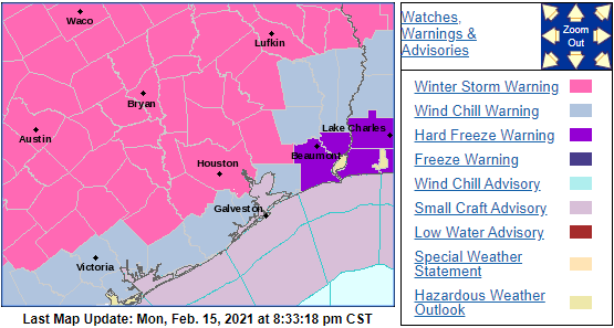
The National Weather Service has issued a Winter Storm Warning for Wednesday’s storm now.

A Winter Storm Warning has been posted for Wednesday’s storm for the counties shaded in pink, essentially from the City of Houston north and west. (NOAA)

Here’s what I can tell you confidently tonight:

  • The precipitation will fall as either plain rain or freezing rain. Sleet or snow are unlikely in our area.
  • Precipitation should break out around Midnight, give or take a few hours Tuesday night/Wednesday morning.

Exactly who sees freezing rain vs. plain rain? That’s the forecast challenge right now, as shallow, dense cold air is not always easy to dislodge. If we look at the HRRR model forecast for tomorrow evening at midnight, you can see roughly where it predicts the freezing line to be located.

The HRRR model suggests that temperatures across most of the northern half of the Houston area will be below freezing when rain begins tomorrow night. (Weather Bell)

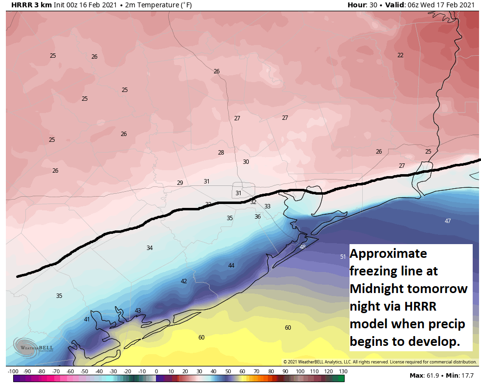
This is essentially just north of US-59 to Houston and east along or just south of I-10 to Port Arthur. The European model and NAM model are slightly warmer than this, and the GFS model is very similar to the HRRR. All models show temperatures getting above freezing by mid-morning or so Wednesday across the entire region. Expect at least a few hours of freezing rain in Houston, with a longer duration as you go north. Total icing may be as much as a glaze to a tenth of an inch across Harris County, with higher amounts possible as you go north into northern Liberty and Montgomery Counties and even more from Walker County northward. For most of us this shouldn’t be a “power outage” issue, but rather a travel one. Expect travel to become difficult to impossible north of I-10 or US-59 after midnight Tuesday night, but we will likely see improvement from south to north after sunrise.

Things could change, but that’s what it looks like right now. We want you to be aware and be smart about this next storm, so that’s why we have this here. Eric will have more for you in the morning. But right now, just focus on getting through tonight. Our thoughts are with you. Please stay safe.

The power situation is disastrous, and it likely won’t be fixed tonight

Millions of customers in the greater Houston region continue to experience some of our coldest weather in decades without the benefit of electricity to heat their homes. (Full disclosure, I am one of them, and have been since 2 am CT. I am typing this from my office, wearing a winter jacket).

To understand what is going on, and when the power might return, I spoke this afternoon with Kenny Mercado, CenterPoint Energy’s Executive Vice President for Electric Utility.

First, it is important to understand how power generation works in Texas. Power plants across the state generate electricity from natural gas, coal, wind, solar, and other sources. This is all put onto the grid, which is managed by the Electric Reliability Council of Texas. Then it is up to companies like CenterPoint to deliver electricity to your home through its network of lines and poles. (Reliant, the sponsor of Space City Weather, markets and sells electricity to the customer. They are not directly responsible for generation or delivery).

What happened

As of 2 pm on Monday, about 1.1 million of CenterPoint’s 2.6 million customers are without power in the greater Houston area. Mercado said customers without power are unlikely to get electricity back today, and quite possibly not tonight—when temperatures are forecast to reach near all-time record lows.

Two things happened last night to contribute to these outages. First, demand was extraordinarily high across the state, Mercado said. And then, beginning at about 1 am, generating units started to shut down. This is almost certainly due to extremely cold conditions. Eventually about one-third of the anticipated capacity went offline. This included a handful of freezing wind turbines, but the majority of the volume losses were due to coal and natural gas plants going offline.

CenterPoint had been planning to manage increased demand overnight and today through rolling outages, which would last about 30 to 45 minutes. However, when power plants began going offline, CenterPoint had to prioritize circuits that fed power to emergency units, such as hospitals and police stations. After this, there just was not enough capacity to implement rolling outages so if your power went out, it mostly stayed out. (Note: If you have power, do your part by conserving energy. If you use fewer watts, access to the grid can be expanded to others).

Although some small generating units are beginning to come back online, Mercado said demand for electricity will increase tonight as temperatures bottom out. Thus, he said, for those currently without power, “It’s pretty risky to assume the power will come back on tonight.” I realize that’s a pretty sobering statement.

Mercado said he is hopeful that decreased demand on Tuesday (statewide temperatures should be 10 to 15 degrees warmer) as well as more generating units returning will allow for power to be restored to more locations, if not all of the state.

Blame to go around

This obviously is a monumental screw-up by the state of Texas, ERCOT, and the companies responsible for power generation in Texas. Why was demand not better anticipated? How are generating plants rated for cold weather production? The list of questions goes on and on. There is plenty of blame to go around, as it seems likely that people will lose their lives due to cold, or medical needs for electricity.

Be wary of those quick to scapegoat wind turbines or any single government official or political sides for this failure. This is a failure of the whole government and a lack of sensible regulation of electricity generators. We need to learn from this mistake so that it is not repeated. After our teeth stop chattering, of course.

Record cold worsens tonight, but the sun is helping — a little

First off, our sympathies are with what we assume are large numbers of our readership without power today. We hope you get it restored soon, but the news has not exactly been great today.

But here is some relatively good news to get you started. As of this writing, both Bush and Hobby Airports are up to 22 degrees. With the sun out, we might be able to squeeze another couple degrees out of things today. That sun is also helping to melt some of the snow and ice on area roadways.

While those roads are still difficult to impossible to traverse, we may restore a little road functionality today. However, after sunset and with temps plunging again tonight, any slush that is leftover on area roads (particularly on side streets in Houston and various area subdivisions) will refreeze into solid ice, making travel tonight virtually impossible, possibly even worse than this morning.

One other safety reminder: If area retention ponds or lakes in subdivisions begin to freeze over, while it will look neat, it will be exceptionally dangerous to attempt to walk on. Simply put: Admire from afar, and please make sure children stay away from them.

Our morning low at both Bush and Hobby was 17 degrees, which is the coldest we’ve registered since the December 1989 cold blast. And we may (probably) dip below that before midnight.

We’re also seeing a true rarity in Southeast Texas: Lake effect flurries and clouds.

Lake effect clouds, flurries, and widespread snowpack dominate the satellite picture over Texas today, a true rarity. (Weathernerds.org)

Two distinct plumes are coming off Lake Livingston and Lake Sam Rayburn this afternoon and even Lake Conroe if you squint. You can also see a plume of “bay effect” clouds coming out of Galveston Bay and into the Gulf. This is why even with the sun out, it may have felt like you were living in a snow globe this morning.

Tonight

So how cold will it get tonight? Clear skies, diminishing winds, and a fresh layer of snow is a recipe for what we call “ideal radiational cooling.” Reliable model guidance tonight ranges from 10 to 17 degrees at IAH/Bush, and in an ideal radiational cooling situation like this, typically you’d subtract a couple more off that.

Record and perhaps all-time record challenging cold is likely tonight. (Weather Bell)

Add in that the models have generally been underdoing the intensity of the cold, and you have a forecast map like the one above from the National Weather Service. There may be some chance that we fall short of these numbers, but I would not be betting on that, and most of the area should expect lows of 5 to 15 degrees, coldest northwest, warmest southeast. Houston’s all-time record of 5° from 1930 is probably safe, but not by much and with little room for error. Either way, tonight promises to be a once in a generation type cold that will unfortunately cause a lot of damage to infrastructure, pipes, etc. We wish our readers the best.

Tuesday and beyond

Not much has changed in terms of what to expect the next couple days. More sunshine tomorrow should help further melt snow and ice on roads and most areas south of I-10 should get above freezing. North of I-10 is another matter, which plays into Wednesday’s outcome. We will continue to be honest that there is still a lot of uncertainty as to how much cold air will remain locked in over the area. Gulf air and onshore flow doesn’t typically have to compete with a snowpack here, so it creates a difficult forecast. What I think we can say for Houston: Most of the metro area should eventually see plain rain on Wednesday, with temperatures above freezing. Based on modeling, we are growing concerned about a very serious ice storm north of about Conroe up to just south of Dallas, but details will likely still be elusive until tomorrow.

With Eric still powerless, I’ll have one final brief update for you once more this around 8:30 or 9 PM. Stay safe, and try to stay warm everyone.

Widespread power outages on Houston’s coldest day in decades

Like many of you, my home in League City has been without power since about 2 a.m. this morning. The power went out just as the winds came up and temperatures really began to plunge across the Houston area.

Before the winter storm impacted the region, officials with the Electric Reliability Council of Texas (ERCOT) said there would need to be rolling blackouts that would last 15 to 45 minutes. However, what is happening across much of the Houston area is more significant than that, or power lines affected by ice.

“These are not rolling blackouts. We are dealing with systemwide power outages across the state,” Houston Mayor Sylvester Turner tweeted shortly after 8 a.m. on Monday morning.

ERCOT is responsible for managing the flow of power across the state. Companies such as CenterPoint are responsible for maintaining the “lines and poles” that deliver electricity to your home. That CenterPoint’s website is experiencing technical problems this morning is not helping to clarify the situation.

One local public official told me that ERCOT has had to take several power generating plants offline, presumably due to the extremely cold weather. This is unfortunate, given that these conditions have been forecast to occur for almost a week now.

I don’t have confidence in any time frame for when power might be restored to the metro Houston area. It’s really outside my area of expertise. But this is a bad situation when Houston is seeing high temperatures around 20 degrees today, and will be much colder tonight, and we can’t be certain when the heat will come back on.

We’ll have a weather update by around 1 p.m. this afternoon.