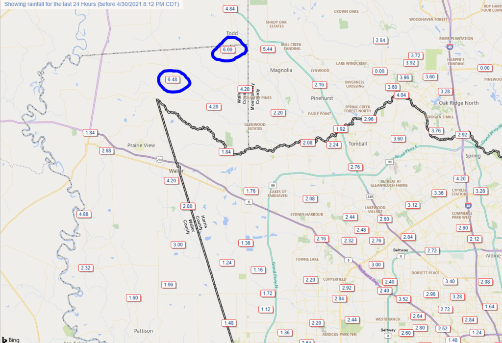
Today has worked out rather well so far for most of the area. South and east of Houston was minimally impacted as expected, with under an inch in most locales. North and west of Houston saw roughly 1 to 3 inches on average. The jackpot occurred in Waller County, as Eric discussed this morning. Threemile Creek at FM 362 just northeast of Prairie View was today’s champion with nearly 6.5 inches of rain.
Waller County, Grimes County, and southwest Montgomery County racked up some big rain totals this morning. (Harris County Flood Control)
While that’s certainly a lot of rain, thankfully flooding has so far been restricted to some sporadic street flooding and some lowland flooding in rural Waller County. If you do need to travel between Magnolia and Prairie View tonight, use caution.
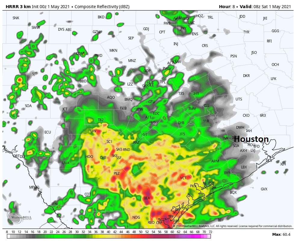
So as of 8:30 PM the radar is quiet in our area. There are two clusters of rain right now: One is just moving east of I-35, east of Austin and San Antonio. The other is sitting offshore between Corpus Christi Bay and Matagorda Bay. Everything looks fairly innocuous now, but after midnight tonight, storms are likely going to explode to our southwest. Significant, widespread heavy rain is likely, well to the southwest of Houston. The area between Corpus Christi and Victoria seems to be the most likely to see significant 4 to 8 inch totals, well away from the Houston area. The HRRR model depiction of what radar could look like overnight is shown below.
Forecast radar from the HRRR model at 2 AM Saturday, which gives you an indication of where the heaviest rain and storm *may* occur tonight. (Weather Bell)
Folks in Wharton or Matagorda Counties will want to pay attention to things overnight I think, but even they may be a bit far enough northeast to avoid the real heavy stuff. This area of rain is likely going to creep closer to the Houston area on Saturday morning. Thankfully, it should also begin weakening around the same time, so while I would plan on some rain for your Saturday morning activities, if everything goes according to forecast, we should see minimal issues on area roadways.
As always with upper lows, there is a tinge of uncertainty underlying everything. However, there is very good model agreement on the general theme of things tonight and tomorrow, so we aren’t especially worried. With that said, we will maintain a Stage 2 flood alert. But honestly, that’s mainly for areas that have already been hard hit, like Waller County, although the rains don’t look too serious there tonight and the first half of Saturday.
Also, folks near Galveston Bay have been removed from the NWS Flash Flood Watch as of late this afternoon. Depending on how things go tonight and early tomorrow, Eric and I will consider pulling back to a Stage 1 alert on Saturday. Fingers crossed.
Saturday afternoon and evening
As of this evening we think most Saturday afternoon plans should be fine. There may be a few showers or some light rain around, so have an umbrella handy. But you might be able to swing most plans without issue. Saturday evening may see conditions go downhill with a line of thunderstorms coming out of Central Texas and sweeping across Houston after 9-11 PM or so. Conditions would improve greatly on Sunday. We’ll update you on that tomorrow morning.
Here’s a quick breakdown of how Saturday looks:
6 AM-Noon: Heavy rain possible, especially west of I-45 and south of I-10. Scattered showers and storms possible elsewhere.
Noon-6 PM: Scattered showers or some light rain, but intensity and coverage of rainfall is expected to diminish.
6 PM-Midnight: Increasing chances of rain and thunderstorms as you get closer to midnight.
We will freshen things up for you again tomorrow morning. Have a good night!
The most intense storms that developed early Friday morning have been winding down as we approach the middle of the day, and this general weakening trend should continue through the afternoon.
For most of us, the rains have been more than manageable so far, with 1 to 2 inches across much of the region. But areas north and northwest of central Houston, including northern Waller County and western Montgomery County, have received 4 to 6 inches. While bayous remain mostly within their banks, these rains have saturated soils in the region.
24-hour estimated rain totals from 11am Thursday through 11am Friday. (NOAA)
Given the unpredictability of this kind of weather system, we still have lots of questions about the forecast. As a best guess, the next area to watch later today will be the Matagorda Bay region, and the potential for storms that develop there to migrate into the Houston area overnight and on Saturday.
Matt did an excellent job of summarizing things in this morning’s post, but the bottom line is that we still expect a situation where some area roadways may see high water during heavy rains. However, we’re not concerned about flooding of homes and businesses at this time, and think bayous are well positioned to handle these rains. For this reason we remain solidly in a Stage 2 flood alert, and don’t anticipate the need to increase this.
There may be some let up in storms on Saturday afternoon or evening, before a final round of storms pulses through the area on Saturday night and Sunday morning. Again, we think this will be mostly manageable for the area’s floodways, but you should be aware of the potential for moderate travel disruptions through Sunday morning.
We will post our update no later than 9 pm CT on Friday evening.
The forecast situation across the Houston area is walking a fine line between very beneficial rainfall and “alright, you can stop now.” Based on model data this morning, it would seem most of the area will see the beneficial aspects, but there remain concerns that some parts of the area may get a bit more than hoped, and because of this, we are going to shift from stage 1 to stage 2 on our Space City Weather Flood Scale.
What does it all mean? You should interpret all of these things to mean that street flooding is a very good bet today and at times through Sunday. It would be a good idea to adjust your plans around the weather the next couple days.
Could it get worse than this? Thankfully, we are starting off with low water levels and dry ground. So it will take a little time for grounds to truly become saturated. Remember, flash flooding is less about how much rain falls and more about how quickly it falls. Rainfall rates are expected to be 1 to 3 inches per hour at times. Initially, that can produce street flooding, hence why the flash flood watch is in effect today. Rapid rises will likely occur within bayous today, but at this point, we would expect them to remain within their banks. After today, the ground will be more saturated, and if we were to see several hours of 1 to 3 inch per hour rain rates tomorrow or Sunday morning, then we could begin talking about something a little more serious. For now, expect street flooding to be the main issue, but we are going to watch things closely today and tomorrow in case this does escalate.
So, you’re bumping to a Stage 2 flood alert? Given that this looks to be a bit beyond just nuisance street flooding (Stage 1) and will likely have some more significant localized impacts (Stage 2), we are going to upgrade our flood alert to a Stage 2 this morning. For most folks, Stage 1 impacts of nuisance street flooding are all you will see. But given the “training” aspect of heavy rain rolling over some places again and again and the excessive rates (1-3″ per hour), we do believe a few locations may see a bit more than just nuisance street flooding, more akin to a Stage 2 event. In the interest of full transparency, the risk of this escalating to a Stage 3 type event, while not especially likely, is not zero, and this is something we will be watching closely this weekend.
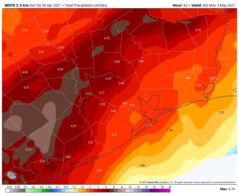
So how much rain are we talking? On average, we expect most places to receive 2 to 4 inches of rain by the time we get to Sunday evening.
On average 2 to 4 inches of rain is likely for most places. There will be areas, particularly west of Houston that could see higher amounts, and very isolated areas may see double-digit rain totals. (Weather Bell)
Some may receive a bit less. With 1 to 3 inch per hour rates, yes, others will receive a good bit more than this. Most models do indicate that the maximum total rainfall in very, very localized areas could reach 10 to 12 inches or even a little more. Given the setup today, I would expect the highest chance of those max totals to be north or west of Highway 59.
Today
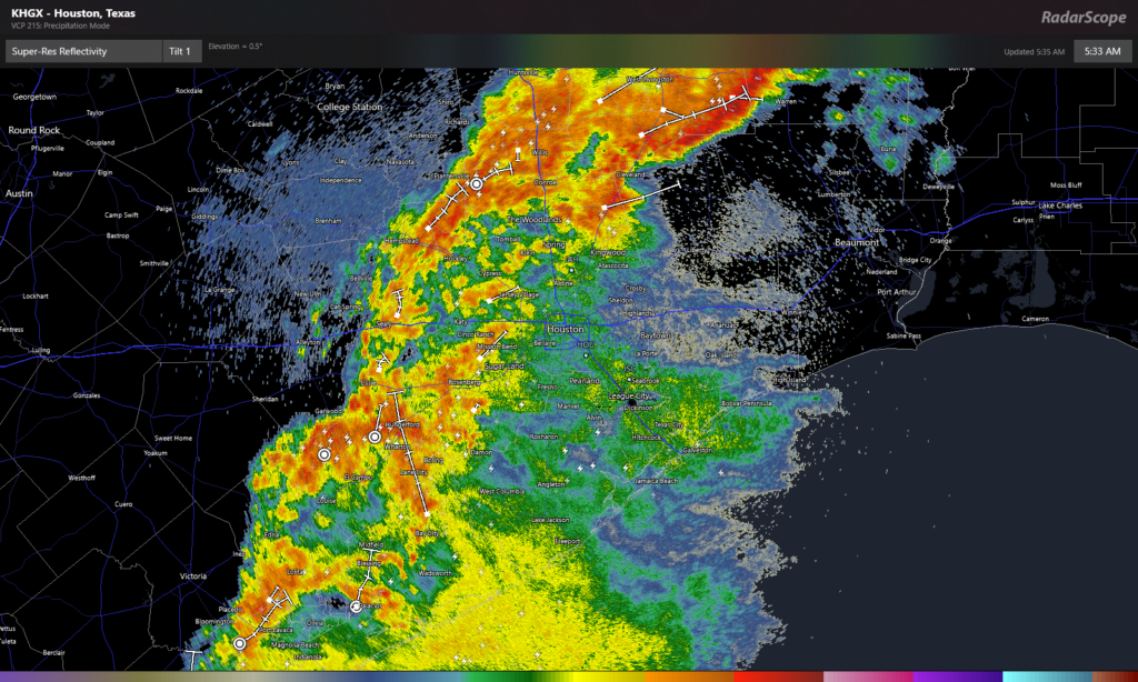
Radar this morning shows heavy rain lined up mostly on the west side of the city stretching on an axis from Port Lavaca through Wharton, the Katy area, Cypress, up into The Woodlands and Conroe and northeast to Lake Livingston.
Radar as of 5:35 AM Friday shows an axis of heavy rain west of Houston, but within that axis rain rates of 1 to 3 inches per hour were already occurring this morning. (RadarScope)
Notably, it’s around Lake Livingston where the heaviest rainfall is causing almost 3 inch per hour rates this morning. Closer to Houston, Kuykendahl at Spring Creek has seen over 1.3″ in an hour as of this writing. As I was about to press “post” here, a Flash Flood Warning was just issued for parts of Waller, Montgomery, and Walker Counties.
Flash Flood Warning including Willis TX, Prairie View TX, Waller TX until 9:00 AM CDT pic.twitter.com/mBgCOai4ZH
Over the next few hours, we expect this band of rain to stay mostly in place, though it may wiggle east or west a bit at times. This will allow for repeated rounds of rainfall on the west side of town, and totals could easily jump up to 2 to 5 inches or more in some spots before this evening. East of Houston? You’re fine for now. Expect at least some rain or showers and storms today, but places like Galveston or League City or Baytown will probably fare okay today with modest rain totals.
Tonight
We may see things taper off this evening for a time, or at least become more intermittent across much of the area. But the next round of rain seems likely to develop overnight, particularly to the southwest of Houston. This batch of rain is likely to try and work into parts of the Greater Houston metro toward Saturday morning. We’ll have more on this later today.
Saturday
Many folks have Saturday plans. Between crawfish boils, the MS 150 bike ride, and other post-vaccination life fun, there is a lot planned this weekend. While I want desperately to be an optimist and tell you it’s going to be fine, the reality is that you should have backup plans in place for outdoor events tomorrow. I will say that the afternoon *might* look better than the morning. We expect that area of rain and storms to weave through the area tomorrow morning and hopefully exit to the east or die off. But there are some models that keep periods of moderate to heavy rain going west and southwest of Houston in the afternoon as well. The reality with upper lows is that forecasts beyond 12-18 hours get sloppy, and we won’t have a great idea on what tomorrow looks like until tonight.
Saturday night & Sunday
One more slug of rain and storms is possibly going to move through later Saturday night and Sunday morning. By Sunday afternoon, the focus of rain should shift into far East Texas and Louisiana and Mississippi. Hopefully by Sunday afternoon we will see some sunshine.
Temperatures all weekend look tolerable, albeit with some humidity with highs in the 70s and lows in the 60s. Sunday could see temps surge past 80° with enough sunshine, however.
Next week
Monday looks like a fine day right now. There may be just enough of a trigger left behind after the weekend storm to allow a shower or storm to pop up, but as of today we would expect the vast majority of the region to stay dry on Monday. Heat and humidity will rule, with lows in the 70s and highs in the middle or upper-80s. A cold front still seems on track to hopefully clear the area on Tuesday. It will bring a chance of showers or storms, and then follow up with hopefully a little lower humidity for Wednesday and Thursday. Right now, this still looks promising, but as noted American philosopher Justin Timberlake once quipped, “It’s gonna be May.” May in Southeast Texas is often where cold fronts come to die. Here’s hoping that’s not the case next week.
We will have another update on today’s rain situation before Noon today.
Good evening. We’re getting closer to the first of two rounds of potentially heavy rainfall for the Houston area, and we’ve seen enough data from the high resolution models to raise our concerns. Therefore we’re issuing a Stage 1 flood alert for the greater Houston region. Such a Flood Scale alert, effectively, means to expect the potential for street flooding in the Houston area.
The first period of heavy rainfall will begin after midnight tonight across the Houston area, and the atmosphere is moist enough to produce rainfall rates of 1 to 2 inches per hour, which can begin to back up roadways. Conditions for heavy rainfall will persist into the morning hours on Friday, and possibly into the early afternoon. Our general expectation for rainfall totals during this first round is 1 to 2 inches for most areas, but there will very likely be some bullseyes that receive up to 5 inches or more.
Then we expect to see something of a lull in rainfall from Friday evening into Saturday morning, before round two begins. Storms will probably get spun back up from Saturday afternoon through Sunday morning, when there may be another 1 to 2 inches of widespread rainfall, with more bullseyes. This is all being driven by a slow-moving upper-level low pressure system that is difficult to predict.
NOAA rain accumulation forecast for now through Sunday. (Weather Bell)
We’ve issued this Flood Scale alert tonight, because we think some areas may see heavy rainfall before sunrise on Friday morning. Matt will have a full update for you early on Friday, and will reevaluate our Flood Scale status at that time. Then, of course, we’ll keep tabs on this system over the weekend as needed.