Storm chances increasing for Friday through Sunday, with a wet weekend on tap

Good morning. The forecast for this weekend continues to evolve and now looks considerably wetter than we anticipated a couple of days ago. This is a dynamic forecast with the kind of weather system that forecasters struggle with. So please be patient with our rainfall predictions over the next few days.

Thursday

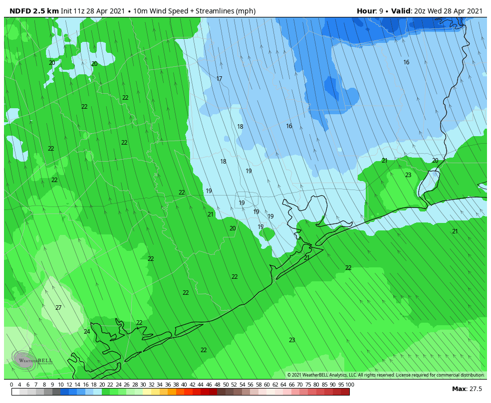
Fairly vigorous storms associated with a cold front moved across Central Texas last night, but they are weakening as they move westward toward Houston this morning. So is the front. As a result, today is likely to be warm, with highs in the low 80s, and mostly cloudy skies for much of the region. There will be some scattered showers, but the better rain chances will come after midnight as the front sags into the area and stalls. Low temperatures will not fall below 70 degrees.

NAM model for dewpoints suggests the “front” will get to about Interstate 10 on Friday evening. (Weather Bell)

Friday

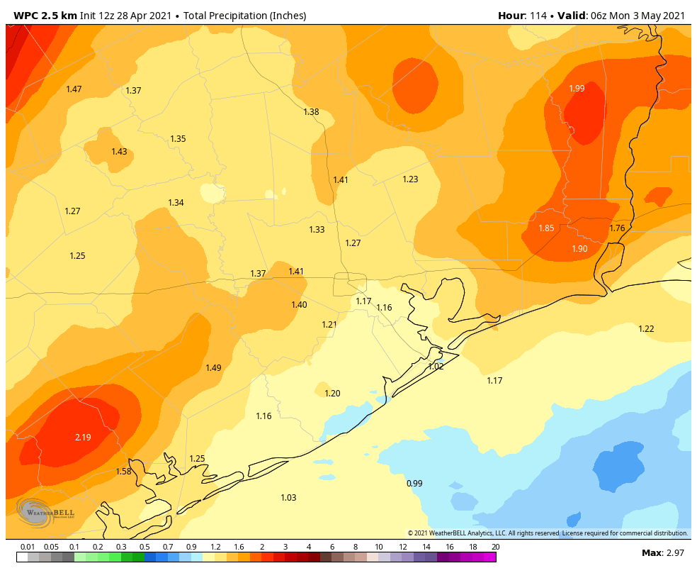
Cloudy skies and showers should limit highs to the upper 70s. Rains should become more widespread on Friday morning across the region, with accumulations of 0.5 to 1.5 inches likely throughout the day. The storms for Friday through the weekend will be driven largely by an upper-level low pressure system, and these are notoriously difficult to predict in terms of rainfall output. This can lead to a boom-or-bust forecast. Some areas of the region may see very little rain, and others enough to flood streets with slow-moving storms. So bear that in mind with regard to this forecast, and the potential for change. Matt and I will be watching this closely, and updating the forecast as needed and as our confidence improves. Lows Friday night will again drop to around 70 degrees as at least some slight to moderate rain chances persist.

Saturday and Sunday

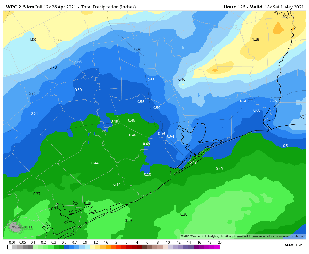
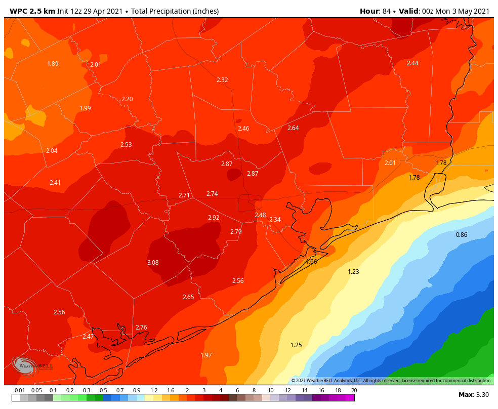
The upper-level low will move more directly over head this weekend and continue to drive the potential for showers on Saturday morning, and then again Saturday night into Sunday. Depending upon how much rainfall the region gets on Friday, these additional rounds of showers may lead to some flash flooding of streets. Overall accumulations from Thursday morning through Sunday will likely be in the range of 2 to 3 inches of rain for most areas, but there almost certainly will be higher bullseyes.

NOAA rain accumulation forecast for now through Sunday. (Weather Bell)

So what does this mean for weekend plans? I know the Bike MS Texas is on Saturday, and at least light to moderate rain is likely along the route. Will there be thunderstorms? I’m less certain about that but it’s a possibility. The bottom line is that, after a string of sunny weekends with sedate weather, we’ll need to pay attention to Mother Nature this weekend. Sunday afternoon offers the best opportunity for clearing skies and lower rain chances, if that helps.

Next week

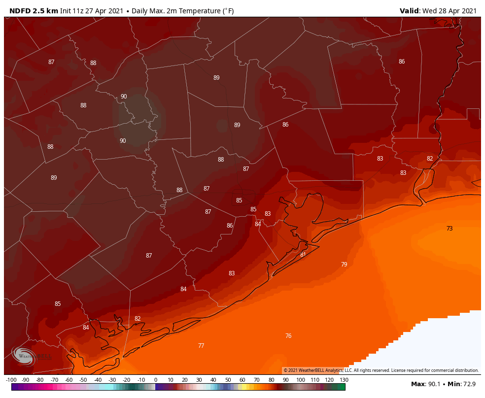
Rains end and temperatures rise to start next week, with highs likely reaching the upper 80s to even 90 degrees for inland parts of the area. Our next front could push through by late Tuesday or Wednesday, and let’s hope this one makes a clean passage into the Gulf of Mexico, rather than getting hung up over Houston. Right now that seems the most likely scenario.

Houston’s weekend forecast turn cloudy, with a chance of showers

Good morning. After several partly to mostly sunny days, Houston’s weather will turn cloudy today. And beginning Thursday, we’ll see at least low rain chances daily through the weekend.

Wednesday

Today will be warm, mostly cloudy, and quite breezy. In response to a low pressure system over central Texas, onshore winds will blow at about 15 to 20 mph, with gusts up to 30 mph. A wind advisory is in effect for areas just west as southwest of Houston, including Brazoria and Fort Bend counties from 11 am to 7 pm. It will be a rather warm day, with highs in the mid- to upper-80s, and the mercury could go a bit higher still for areas that see snippets of sunshine this afternoon. Rain chances are near zero, with a capping inversion in place, but we can’t entirely preclude a few sprinkles. Lows tonight will not drop below 70 degrees.

Look for strong southerly winds on Wednesday, with higher gusts. (Weather Bell)

Thursday

A cold front will be pushing through Central Texas overnight, and this will send a line of showers and possibly thunderstorms toward the Houston area. This line, which likely will be weakening as it moves into a more stable air mass, should reach College Station by around sunrise, and the Houston area itself during the afternoon hours. As for accumulations, its sort of a crap shoot, but I’d estimate most areas will see one to two tenths of an inch of rain.

It now appears that this line of showers, and an attendant weak front, will move off the coast Thursday evening. Daytime highs will be in the low 80s, with cloudy skies. Overnight lows will probably drop into the upper 60s.

Friday

At this point Friday looks mostly dry, but we can’t entirely rule out at least some scattered showers in the wake of the weak front. Skies will be mostly cloudy with highs likely somewhere in the upper 70s for most areas. Lows Friday night should again drop into the upper 60s, but my confidence in temperatures is not great.

Saturday and Sunday

Both weekend days should see mostly cloudy skies, and highs of around 80 degrees. The bigger question concerns rain chances, as a few disturbances pass across the area. I think both days will have about a 40 percent chance of at least light rain showers. For those participating in the Bike MS Texas on Saturday, that’s the bad news. The good news is that winds will have shifted to come from the south and southeast on Saturday, so there are very good odds that riders will have a tailwind going from Houston to College Station. Overnight lows will probably be in the upper 60s to 70 degrees.

NOAA rain accumulation forecast for now through Sunday. (Weather Bell)

By Monday, with sunnier weather on the way, highs should start to push into the mid- to upper-80s. Most of next week looks fairly warm, as one would expect for early May.

Houston to warm this week before an some semblance of a front arrives

Summer is coming, and so is the Space City Weather app. On Monday, Dwight Silverman teased an early version of our forthcoming app for Android devices, and we’re also beginning to test it out on Apple devices. We plan to release the app before the beginning of the 2021 Atlantic hurricane season, and we’re very excited to share it with you. It will be free to download, with no in-app purchases.

Tuesday

It’s a rather sticky morning across the region. Outside my home, the temperature is 75 degrees, with a dewpoint only slightly lower. Skies are overcast, and we’ll only see a few breaks later in the day. The cloud cover should help to limit high temperatures, keeping them in the low 80s. Winds will blow out of the south at 10 to 15 mph. Tonight will be similarly muggy.

Wednesday

This will be a warm day. Southerly winds will continue to blow on Wednesday, turning a bit gusty, but there should be a few more breaks in the clouds. This sunshine will goose temperatures, and I think parts of the region will likely see highs in the mid- to upper-80s. While we can’t entirely rule out a few showers Wednesday night, the better rain chances will come on Thursday.

High temperature forecast for Wednesday. (Weather Bell)

Thursday

The region’s next front will approach Houston on Thursday. This will bring an increased rain chances, but there’s not a whole lot of consensus in the model forecasts. There are some hints that we may see pockets of heavy rainfall, but most of the systems we’ve seen this spring have significantly underperformed in terms of rainfall. So my expectation is for a few tenths of an inch of rain with this front, but it’s something we’ll need to watch. High temperatures will likely get to about 80 degrees, with mostly cloudy skies to go along with our rainfall. As for the front, it will likely slog toward the coast, pushing offshore overnight.

Friday, Saturday, and Sunday

I’d love to tell you that we’ve got a great handle on the forecast for this weekend, but that would mean I’d be lying to you. The reality is that some of the guidance, including the European model, have backed off on the amount of dry air coming in with Thursday night’s front. For now, my best guess for Friday through Sunday is highs of around 80 degrees, lows in the 60s, with partly sunny skies and a modicum of drier air. By Monday we’ll probably be on a significant warming trend, likely headed back toward the upper 80s.

Clouds return for much of the week, with a wet Thursday likely

About nine weeks have now passed since the brutal winter storm that crippled the state of Texas’ electricity generation system. Since that time, however, Houston has enjoyed mostly spectacular weather. It’s difficult to quantify things, but the large majority of weekends have seen mostly sunny skies, dry air, and mild temperatures. This most recent weekend brought more of the same weather and the (very) early outlook for next weekend is not bad. I hope you’ve enjoyed it, because March and April typically offer some of this region’s nicest weather, and this year both months delivered.

Monday

Temperatures this morning are in the mid-60s, and they will climb into the low 80s this afternoon with partly sunny skies. Winds will blow from the southeast at about 10 mph, with higher gusts, and this will signal the return of the onshore flow. With this influx of more moist air humidity levels will rise, and overnight temperatures will likely not fall below 70 degrees for much of the metro area tonight.

Tuesday

Skies will be mostly cloudy, and this likely will help to limit temperatures in the low 80s. Winds will continue to blow from the southeast at 10 to 15 mph, and this will pump up moisture levels for rain chances later this week, but for now Tuesday should remain free from precipitation. Lows Tuesday night will only drop into the low 70s.

Wednesday should be the warmest day for much of the region. (Weather Bell)

Wednesday

Another day with a breezy flow off the Gulf of the Mexico. It’s possible there will be some breaks in the clouds on Wednesday, and if so this will allow temperatures to climb into the mid- to upper-80s. This likely will be the warmest day of the week, and for now at least rain chances should remain about 10 percent or less. Lows will again be warm.

Thursday and Friday

A front will approach the region on Thursday and should cross the area by Thursday evening. This front will bring a healthy chance of showers to the region. Right now accumulations for most areas will probably be in the one-tenth to one-half inch range, with most rain during the daytime on Thursday. Highs on Thursday should be in the low 80s. Some rain chances will linger on Friday, but any accumulations should be very slight. Friday will see partly sunny skies and highs in the upper 70s.

NOAA rain accumulation forecast for now through Friday night. (Weather Bell)

Saturday and Sunday

For now, we think Houston will see a drier pattern this weekend, with at least partly sunny skies. As we enter May, it’s difficult to beat highs in the low 80s with moderate dewpoints. We can’t entirely rule out some rain chances, at least not yet, but overall the weekend forecast looks promising at this point.