Storm activity wanes today, but this weekend and early next week look fairly wet

Good morning. Before jumping in to the forecast, which should be a little bit drier in the days ahead before a wet weekend, I wanted to share a couple of housekeeping notes.

  • I recently joined the popular Houston Moms blog to discuss hurricane season and preparedness. You can watch parts one and two of the video.
  • Michael Hardy wrote a profile of me and Space City Weather for Texas Monthly that was published on Tuesday. It provides a great overview of why I got into this business, and the philosophy Matt and I have toward communicating weather information.

Wednesday

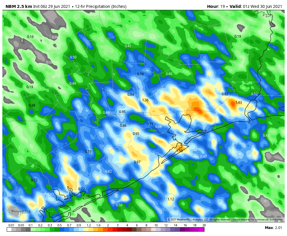
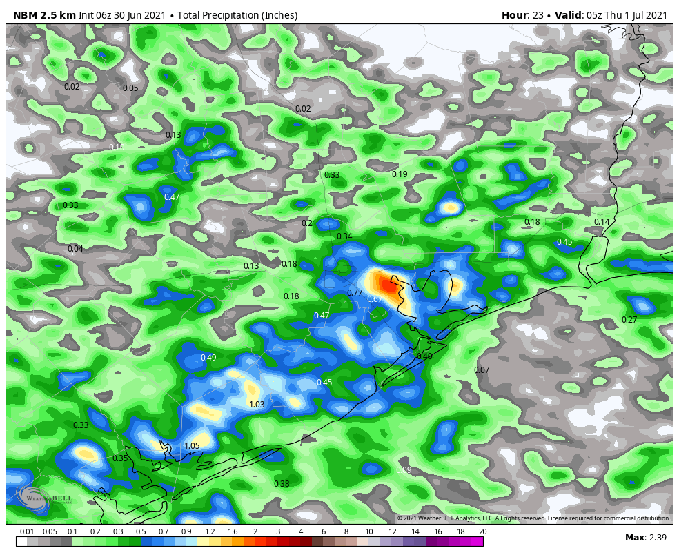
The Houston area radar is more calm this morning, but I still anticipate scattered to widespread shower activity to develop later today. Rain is most likely south of Interstate 10 this morning before spreading further inland this afternoon. With less moisture available, I think most of Houston will see 0 to 0.5 inch of rain today, but we could see a few bullseyes of 1 to 2 inches closer to the coast. Winds will be light out of the east, and with partly sunny skies high temperatures should reach 90 degrees, or the low 90s, later today.

National Blend of Models forecast for rain accumulations on Wednesday. (Weather Bell)

Thursday and Friday

If we’re going to see lots of sunshine, and lower rain chances, these are the days this week. That’s not to say it won’t rain in Houston on Thursday and Friday, but most of us probably won’t see any rain, or if we do, accumulations should not go beyond a tenth of an inch or so. As a result, these days will be warmer, with highs in the low to mid-90s. Enjoy the sunshine, because the pattern will turn stormier this weekend.

Saturday and Sunday

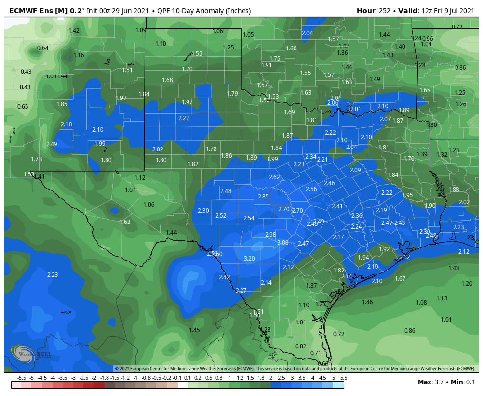
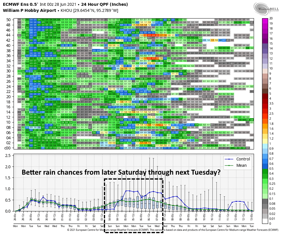
By Friday night or Saturday morning, a weak cool front—no, it won’t bring much in the way of cooling—will approach and likely stall over our region. The effect of this will be to draw moisture from the Gulf of Mexico inland, and set up the potential for slow-moving showers. The details remain to be worked out, but we can probably expect accumulations of 1 to 3 inches this weekend, with higher isolated totals. Rain chances will be decent overnight as well, so I would not feel entirely confident about fireworks chances on July Fourth. Highs will be in the upper 80s to 90 degrees. The bottom line: If you have outdoor plans this weekend, have an indoor backup plan.

NOAA rain accumulation forecast for Saturday and Sunday. (Weather Bell)

Next week

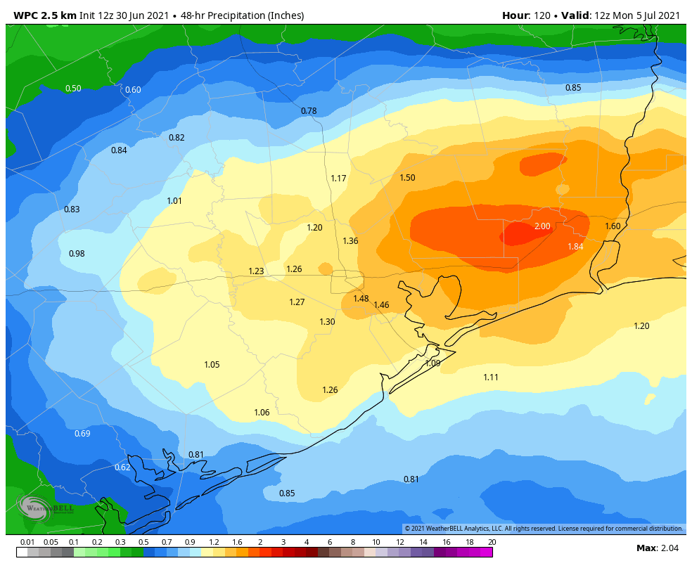
The stalled front should remain in the vicinity of Houston through about Monday, but the atmosphere remains unsettled after this. If anything the potential for rain increases from Monday through about Wednesday, and overall I think our region may see on the order of 5 to 7 inches of rain from now through the middle of next week, if not more. Again, the details on this are to come, but it’s something we’ll be covering closely. Conditions may finally turn sunnier and hotter by Thursday or Friday, but no promises from us.
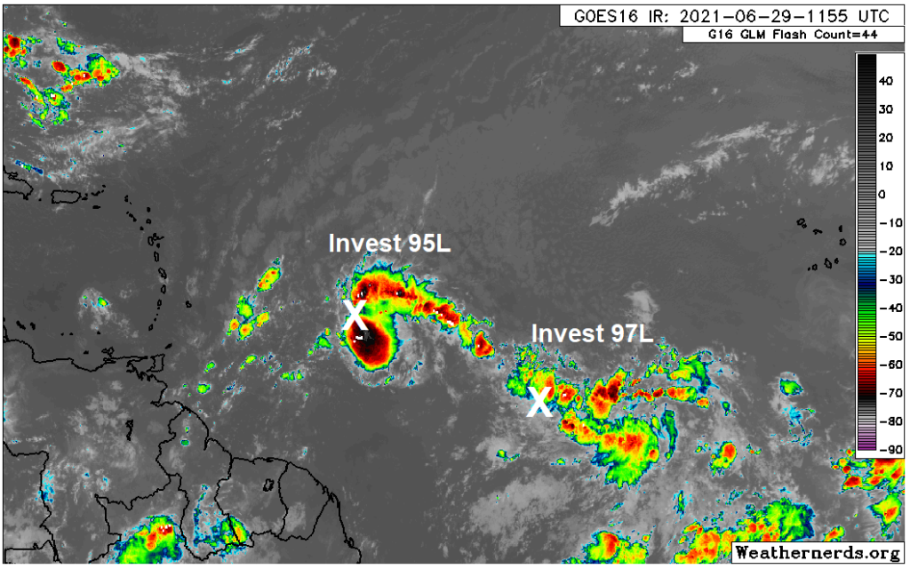
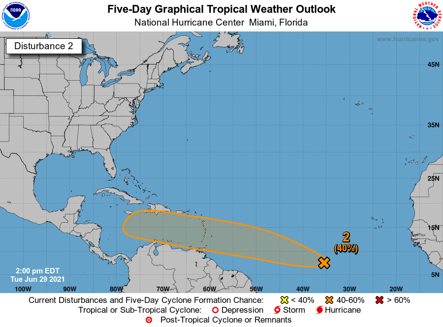
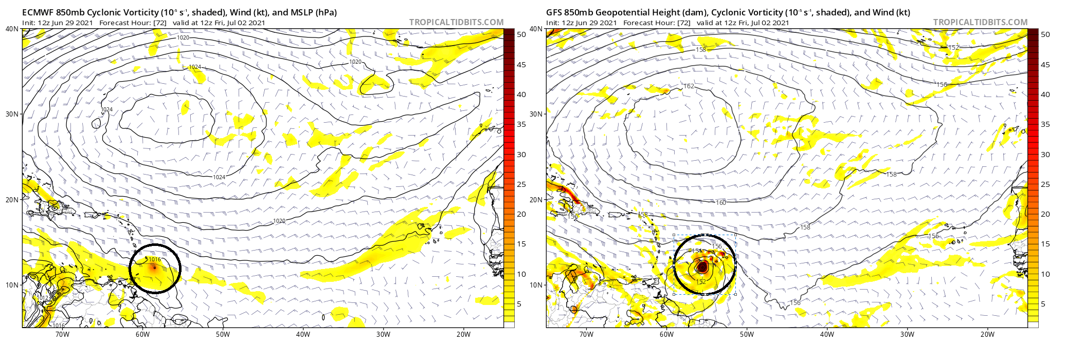
Tropics

Matt provided a good rundown of the tropics on Tuesday, and we’re continuing to watch the development of Invest 97L. This morning, the National Hurricane Center has upgraded its chance of becoming a tropical storm or depression within the next five days to 80 percent.

(National Hurricane Center)

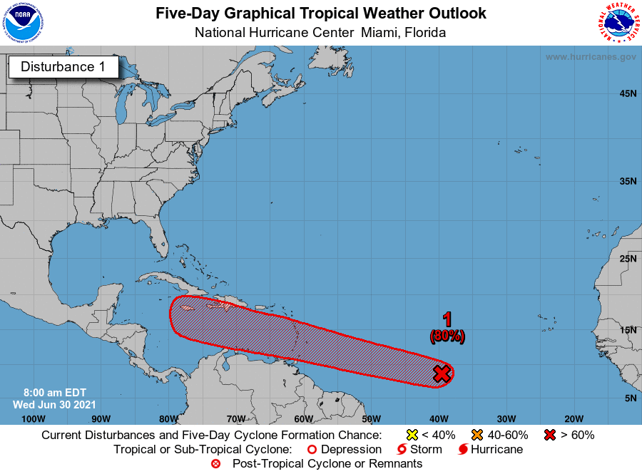
The most likely scenario remains that this system eventually succumbs to a hostile environment in the Caribbean Sea this weekend, but we can’t rule out something making it into the Gulf of Mexico next week. For now, my money is on Invest 97L petering out, but we’ll continue to track it for you.

Eye on the Tropics: Atlantic continues buzzing with low-end activity

Welcome to another edition of our weekly tropical outlook. The last two hurricane seasons have been full of many quick developing, lower-end storms. Some folks deride the National Hurricane Center for “wasting time” naming these things, but if it looks like a duck and quacks like a duck, whether bloated, thin, short, tall, round, square, or what, it’s still a duck. And that’s why we have added another storm since last week.

If you blinked, you might have missed Tropical Storm Danny yesterday, but it formed off the coast of South Carolina, made landfall and weakened to a depression within about 12 to 18 hours. It wasn’t quite like Imelda, and its fast forward motion will keep it from becoming a Carolina or Georgia version of Imelda, but it went quickly, and it came from an area I didn’t even mention a week ago. So go the tropics.

Tropical outlook in a sentence

While there is one area in the Atlantic for us to monitor, it will likely face an uphill battle to make it to the Gulf in a position to develop any more significantly.

Satellite imagery from earlier this morning shows invests 95L and 97L in the Atlantic. While 95L looks beefier, it is less likely to develop significantly, while Invest 97L may have more of a future. (Weathernerds.org)

Invest 95L

The area people have been watching a good bit since last week is Invest 95L, which today does not pose much risk of making it to the Gulf. It will likely either stay disorganized and continue across the Caribbean (where it will face mountains of shear) or it will develop a little and get pulled north toward the Bahamas, Florida, or Eastern Gulf. Colloquially, some of us in meteorology will use the phrase “weaker, wester” to describe these things. It seems highly unlikely that 95L makes it to Houston. The National Hurricane Center has just lowered odds of development risk on 95L to 30 percent over the next 5 days.

Invest 97L

The one area I want to focus on is the new Invest 97L, which now has a 40 percent chance of developing over the next 5 days according to the National Hurricane Center (up from 20 percent this morning).

The NHC has boosted development odds for newly minted Invest 97L to 40% over the next 5 days. (NOAA)

As you can see on satellite above, Invest 97L has some loose thunderstorm activity, but it is not yet organized. The one thing about Tropical Storm Danny: Say what you will about it being “pathetic” or whatever, but at least it had that swirly cinnamon bun look going for it yesterday. 97L is not there yet.

Invest 97L will be steered west or west-northwest around the periphery of high pressure in the Atlantic. Both key operational models, the Euro and GFS tend to buy into Invest 97L developing over the next three days. However, they differ significantly on *how* much development occurs. I’ve plotted the GFS and European models below, showing you what we call 850 mb vorticity. What? That’s a good map to look at to gauge where things stand with potential development risk. And you can indeed see both the GFS & Euro show ample “spin” (yellow & orange) and low pressure near the entrance to the Caribbean on Friday morning, with the Euro on the left and the GFS on the right.

Both the Euro and GFS develop Invest 97L over the next 3 days, but the GFS is light years more aggressive even over the next 18 to 24 hours, which means this thing better hurry up and organize if we are to end up with whatever the GFS shows. (Tropical Tidbits)

The difference is that the GFS is far, far more aggressive in organizing Invest 97L over the next 3 days. Why does this matter? Because the GFS has been the only model showing this coming to the Gulf as a significant storm. If it’s unrealistically strong 3 days from now, that doesn’t bode well for its accuracy on days 7 to 10. So right now, using context clues, there is a good shot we see the potential for a tropical depression or storm approaching the southern Lesser Antilles by the end of this week.

From there, this will have a mountain to overcome. The Caribbean is full of shear, and any system will not be greeted by favorable conditions on the other side of the islands. While the GFS keeps this going somewhat across the Caribbean, the Euro rips it to shreds. Neither model’s ensemble is particularly bullish on this system’s future either. So sitting here on Tuesday, I find it difficult to think that Invest 97L will make it to Texas as an organized tropical entity.

That said, the weather pattern over Texas is likely to say fairly cool and wet for most of the next 2 weeks. It gets tough to think that a tropical system makes it here as an organized system, but a bigger risk could be that the moisture gets here and exacerbates an already wet Texas.

Rainfall over the next 10 days is expected to average about 1 to 3 inches more than normal in Texas, which is about as strong a signal as you could ask for for a wet pattern. (Weather Bell)

That’s a wet Texas to say the least. So the bottom line is that we’ll want to sort of watch this system for its moisture. But at least at this point there’s no reason to think it’s going to become a problem for us, and I can’t point you to any reliable, outlier model guidance that says it will. We will let you know if that were to change.

Beyond this, expect a quieter tropics for a little while, as the atmospheric background signals (what we often call the “intraseasonal phase” of the atmosphere) is fairly suppressed over the Atlantic basin, meaning it will inhibit storm formation. That doesn’t mean we won’t see a storm or two, but in general, storm development risk should be lower than it has been. This could allow for our first significant Saharan dust event of the summer as well sometime in mid-July. We will see.

Another stormy day on tap before perhaps a few somewhat drier days

Much of the Houston region saw 1 to 3 inches of rain on Monday, with some higher bullseyes near LaPorte and Baytown on the east side of Houston. Today will see a similar setup, although with slightly less favorable conditions, overall totals should be less for most. The latter half of the week should see some sunshine, but we’re still looking at a wet holiday weekend.

Tuesday

The atmosphere remains moist, with lift from an upper-level system, but the overall dynamics favor less storm coverage today. That doesn’t mean it won’t rain. Most of Houston will probably see 0.25 to 2 inches of rain today, with some isolated areas of 3 inches along and east of Interstate 45. Area bayous should be able to handle these rains, so we’re probably looking at street flooding, at worst, in hard hit areas. Like on Monday, storms should wind down pretty quickly after the sun sets.

Otherwise, skies today will be mostly cloudy, with southeast winds, and highs will only reach the mid-80s. (I took a walk on Monday evening and, dare I say it, conditions felt almost pleasant?) Lows Tuesday night will drop into the mid-70s.

Rain accumulation forecast for Tuesday. (Weather Bell)

Wednesday

As moisture levels drop and the atmosphere becomes a little less favorable, the chances for heavy rainfall will diminish significantly on Wednesday. However, I think much of the area may still see at least some light to moderate rainfall during the day time to go along with partly sunny skies. Highs will be near 90 degrees.

Thursday and Friday

These days should both see partly sunny skies, with highs in the low 90s for the most part. Rain chances aren’t going to fall back to zero, but less than half of the area will probably see rain. We should get a chance to dry out a little bit before the next round arrives.

Atmospheric moisture levels will be significantly above normal this weekend. (Weather Bell)

Saturday and Sunday

Yet another front will approach our region and stall out this weekend, and it will lead to elevated rain chances over the holiday weekend. The forecast has shifted a bit, with the better rain chances now expected on Saturday, with perhaps slightly less coverage on July 4th. Anyway, expect rain this weekend, perhaps to the tune of 1 to 2 inches. Sunday may see some partly sunny skies, but still has the potential for rain, and it is possible that fireworks displays may be impacted. Highs will drop back to around 90 degrees both days. Rain chances and cloudy skies continue into early next week.

The tropics remain active, especially for late June. Matt will have a full update later today.

A stormy start to a wet week in Houston

Good morning. This will be a fairly wet week, with more clouds than sunshine. Rain chances will peak today and Tuesday, before a bit of a lull, with healthy rain chances returning for the Fourth of July weekend. Will the holiday be a total washout? Probably not, but it’s too early to tell whether it will rain during our much anticipated fireworks’ shows.

Monday

Pretty much everyone in the Houston region is guaranteed to see rain today as an upper-level low pressure system combines with a very moist atmosphere. But whereas some regions see intermittent light showers, others will see downpours. So far storms have moved steadily from southeast to northwest, and this motion has limited rainfall rates to 1 to 2 inches per hour as storms move through. Our primary concern is that, in a few areas, these storms may grind to a halt.

Overall, I expect much of the region will see 1 to 3 inches today, with a few bullseyes of 3 to 5 inches closer to the coast and south of Interstate 10. A few low-lying roadways may flood, but overall these totals should be manageable. Do take care during your morning and evening commute, however. Highs today will likely crest in the mid-80s, with lows dropping into the mid-60s tonight as shower activity wanes, but does not entirely go away.

Area most at risk for heavy rainfall on Monday. (NOAA)

Tuesday

Tuesday should be a bit like Monday-lite, with the potential for heavy rainfall again, but likely less coverage and less intensity as overall conditions are a bit less favorable. Still most of the area will again see at least some rainfall, with highs in the upper 80s.

Wednesday, Thursday, and Friday

As the upper-level low moves away, rain chances will back off a bit, leaving us with partly sunny days. Some sea-breeze driven showers will still be possible during the afternoon hours on these days, but at this point I think they’ll probably be more “miss” than “hit” at this point. Highs will likely rise into the low 90s, which is not terrible as we get into July.

Saturday and Sunday

After a few drier days, in terms of rainfall, precipitation chances will probably be on the rise this weekend as the atmosphere turns more unstable. Unfortunately, we’re still a little too far out to have much confidence in the overall forecast, but right now I’d pencil in 60 percent rain chances each day, which could be problematic for outdoor activities. Given that we’re still several days away, this forecast is far from locked in, but something to keep in mind.

Elevated rain chances possible this weekend. (Weather Bell)

Tropics

We’re likely to see tropical activity pick back up this week after a lull in late June, but for now we don’t see any real threats to Texas or Louisiana over the next week or two. We’ll have more in our weekly tropics report tomorrow.