Houston to celebrate “Fall Day” just two days from now

A few years ago Dan Reilly, the warning coordination meteorologist at the local National Weather Service, and I were discussing fall cool fronts. The first day it truly felt like fall in Houston should be a holiday, we agreed. Every year since, Space City Weather has designated the first day it will truly feel like “fall” in Houston as Fall Day. This year, that day comes on Wednesday, after a front moves through overnight and brings much cooler and drier air to the region. It may not be an official holiday, but it sure should be one after we survive summer.

Low temperature forecast for Wednesday night and Thursday morning. (Weather Bell)

Monday

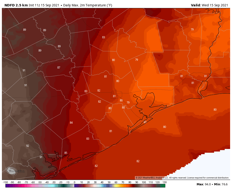
Before we get to the front, however, Houston will experience a little bit more heat. Highs today should reach at least the low 90s, with sunny skies. Rain chances are essentially zero north of Interstate 10, and perhaps 10 to 20 percent closer to the coast. Winds will be light, out of the southwest, at 5 mph. Conditions overnight will be warm and muggy.

Tuesday

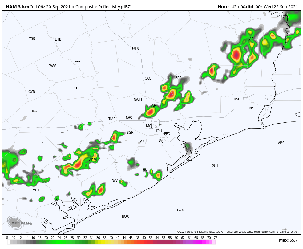
This will be another hot, humid, and sunny day in Houston, but it will be the last one for awhile. That’s because a bona fide front will push through Houston. The timing is a bit uncertain yet, but expect a broken line of showers and thunderstorms to reach central Houston perhaps around sunset, and push off the coast during the late evening hours. After this, drier air will move into the region during the overnight hours. Most of the region should wake up Wednesday morning to dewpoints in the 50s.
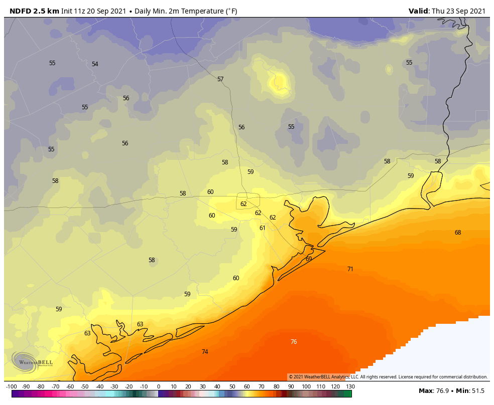
NAM model forecast for the radar at 7pm CT Tuesday. This is only a very rough estimate. (Weather Bell)

Fall Day

This will be a fine day, with sunny skies, moderate northerly winds of 10 to 15 mph, and highs in the low 80s. As the sun drops toward the horizon, so too will temperatures. Inland lows likely will reach the upper 50s, with areas closer to the coast staying in the low 60s.

Thursday and Friday

These should be sunny, pleasant days with highs in the low 80s, and overnight lows down around 60 degrees.

Saturday and Sunday

We should see some warming over the weekend, but even with mostly sunny skies I don’t think highs will get above the mid- to upper-80s. Dewpoints will remain lower than summertime levels, so while it won’t be cold, it won’t be unpleasantly steamy, either.
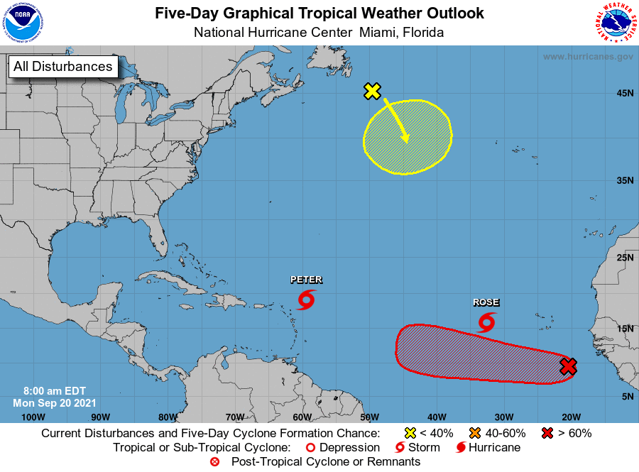
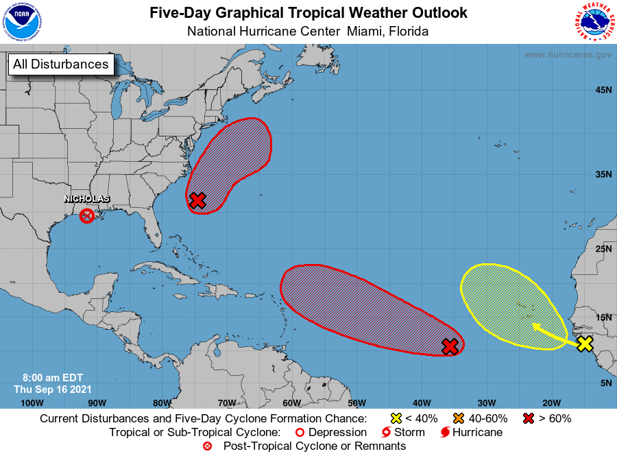
Monday morning tropics forecast. (National Hurricane Center)

Tropics

Call it the Charlie Hustle tropics forecast, with Peter and Rose active in the Atlantic Ocean. Fortunately, neither storm presents a significant threat to any landmasses. Beyond this, the red X off the coast of Africa could very well develop as it moves west across the Atlantic Ocean. This system seems unlikely to be bound for the Gulf of Mexico, however. Overall, in fact threats to the Gulf over the next 10 days are fairly low. I’m not complaining.

Warmer weather returning, but the odds of Houston’s first true fall front increase for next week

We continue to enjoy fairly quiet weather across the region in the wake of Hurricane Nicholas. Today will be no exception, though things get a bit more unsettled this weekend. But the drumbeat regarding our first legitimate autumn cold front is growing louder today. For now at least, it would seem that some very nice weather is on the horizon for the back half of next week. More on that below.

Today

Friday will probably be similar to Thursday in a lot of ways with clouds and sunshine sharing the sky. Yesterday saw upper-70s at Bush Airport compared to mid-80s at Hobby. Today should probably see 90 or better in a lot of locations, provided the sun is out a good bit. Otherwise, look for mid to upper-80s, still warmer than Thursday.

A warm but fairly pleasant Friday should be in store for most of the area, with little rain chance. (NOAA)

Rain chances are quite slim to none today.

Saturday & Sunday

We sort of settle back into more of a typical late summer pattern this weekend, as Eric’s been noting the last couple days. The coverage of showers and storms expected has wobbled a bit lately, but it looks like we’ll have decent coverage of showers tomorrow and maybe a bit less coverage on Sunday. We’ll have a good bit of humidity and highs in the upper-80s to low-90s depending on cloud cover. Morning lows should be in the 70s.

Early next week

Monday looks pretty good right now with just a chance of a shower or storm but otherwise partly to mostly sunny. Look for morning 70s and afternoon 90s. Tuesday looks similar, though with perhaps a slight nudge up in rain chances.

Cold front update!

On to what should be the good news. Both the GFS & European models are in agreement on a cold front coming into the area on Wednesday. They differ on exact timing and how strong it will be, but they both show it distinctly in their forecasts and ensembles for the most part. Here are the low temperature charts from the 51 Euro ensemble members and the 31 GFS ensemble members. I’ve boxed in the period for next week.

Both the Euro (left) and GFS (right) have good agreement among the majority of their ensemble members for a cold front through Houston next week, though they differ on exact timing and amplitude. Click to enlarge. (Weather Bell)

The Euro is at nearly 100 percent agreement on a pretty potent cold front reaching the area, closer to Wednesday morning. The GFS, however looks to be at more like 50 to 55 percent agreement, with most ensemble members not quite as cool as the Euro. But, when you look closer at the GFS, it does bring a strong front south; it just manages to whiff to our east, bringing most cool air into Louisiana, rather than Texas. That same chart above and to the right shows more like 90 percent agreement in a front when you look at it for Lake Charles, which seems a bit odd to me.

I would say there’s a bit of uncertainty right now on the finer details, like whether it’s 60 to 65 or 65 to 70 in the mornings late next week (though I will say that it’s quite tantalizing to see several European ensemble members in the 50s). In terms of getting the front through Houston, that’s looking like an increasingly likely proposition. Assuming that’s the case, expect a period of showers or thunderstorms Tuesday night or Wednesday, followed by mostly sunny conditions for the end of the week. Highs would be in the 80s with low humidity. And again, we’ll see about how cool morning lows go.

Tropics

The Atlantic remains active with two areas still holding at a 70 percent chance of development over the next 5 days. Both are expected to head out to sea.

While the tropics remain busy, as is typical for September, none is a realistic threat to the Gulf. (NOAA)

Some folks will continue to point to Invest 95L (the red area in the central Atlantic) as being concerning, but in order for it to come more west, it would have to remain a disheveled mess and would likely get ripped apart before it got far enough west to be concerning. Oh, and with a cold front likely to get well offshore next week, the western Gulf is protected through at least next weekend. In other words, you can rest easy. No concerns for us.

Have a great weekend!

One of the year’s last summer-like weekends lies ahead

Good morning. Houston will see one more partly to mostly cloudy day before a string of mostly sunny days. Temperatures will likely reach the low 90s during the coming period, but we’re increasingly confident that some sort of front will make it through our area during the middle of next week. How strong? We’ll have to wait and see.

Thursday

Although Nicholas has dropped below tropical depression strength in Louisiana, we’re continuing to see wrap-around clouds and light northerly winds from the system. This will contribute to another mostly cloudy day, and should help to keep highs in the mid- to upper-80s for most of the area. A little bit of misty rain is possible, but most of us should remain dry. Lows tonight will drop into the mid-70s.

Friday

We’ll see a mix of sunshine and clouds on Friday, and the return of light southerly winds temperatures will probably nudge up to around 90 degrees. We can’t rule out a passing shower, but any rain should be fairly isolated and fleeting.

NOAA rain accumulation forecast for now through Sunday. (Weather Bell)

Saturday and Sunday

The weekend should see mostly sunny skies with highs in the neighborhood of 90 degrees. Some showers will be possible as moisture from the Gulf of Mexico increases, but rain chances on both days are probably only about 30 percent now. This should be one of the last truly summer-like weekends of 2021, so if the beach is your thing, do your thing.

Next week

We’ll remain in a summer-like pattern through about Wednesday of next week. After that time it does look like some sort of front will push through, although whether its the “upper 60s and some drier air” kind of front or something more like “60 and unbelievable” is yet to be determined.

Tropics outlook for Thursday morning. (National Hurricane Center)

Tropics

There’s nothing for the Gulf of Mexico to be concerned about now, or likely for at least the next several days. The end of the tropics season for Texas is near, but we’re not ready to make that call yet.

Houston’s weather to return to a more typical late-summertime pattern

Good morning. After a week of all-Nicholas, all-the time, we’re returning to a period of more normal late-summertime weather in the Houston region. As for the hurricane, it’s now a tropical depression nearing southwestern Louisiana, and should soon dissipate. After more clouds today our weather will turn more sunny, and highs around 90 degrees likely return for the weekend.

Wednesday

Some very light rain has fallen across parts of the area overnight, and additional spotty showers will be possible later today. But for the most part, this should simply be a cloudy day with moderate high temperatures of about 80 degrees. As we’re on the backside of Nicholas, winds will be out of the north or northwest for much of the day at 10 to 15 mph. Tonight should be mostly cloudy and pleasant, with lows dropping to around 70 degrees in the city.

High temperatures today will be near 80 degrees for most of Houston. (Weather Bell)

Thursday and Friday

Skies should start to become at least partly sunny on Thursday, and this will help to push highs into the mid- to upper 80s tomorrow, and possibly as high as 90 degrees on Friday. Rain chances for both days are low, perhaps 20 percent, but not non-existent.

Saturday and Sunday

After a few days of a drier overall flow, we’ll start to a see a more pronounced return of moisture from the Gulf of Mexico this weekend. This will result in rising rain chances, but I think there’s still a shot for mostly sunny skies on Saturday. Highs are likely in the low 90s. Even if most of us get through Saturday without too much rain, showers probably become more widespread on Sunday, with perhaps two-thirds of the area seeing some rain. Accumulations shouldn’t be huge, perhaps one-quarter to one-half inch for most.

Next week

Daily shower chances remain in the forecast through the middle of next week, with highs likely settling out in the upper 80s to low 90s. At that point we’re going to be looking for our first “fall” front of the season, which knocks temperatures below 65 degrees in Houston. It’s possible that is coming around next Thursday or so, but at this point we have no guarantees. But I’m ready. I suspect you’re ready as well.

Tropical outlook for Wednesday morning. (National Hurricane Center)

Tropics

The tropics remain very active, which is usual for this time of year. But we’re getting closer to the end game for the Texas coast, in terms of hurricanes. And while there is the potential for a few tropical systems to develop this week, none appear likely to trouble the Gulf of Mexico (even that ominous looking red blob in the eastern Atlantic). I suspect you’re OK with that as well.