Good morning. Temperatures range from the mid-30s well north of Houston to about 50 degrees right along the coast. Overall, the forecast remains the same, with this being the nadir of temperatures for awhile, and the beginning of a warming trend that will last until … ? That is the question. Certainly we’ll be warm through Christmas Day and the weekend. Perhaps the next front comes by Tuesday or so of next week. More likely, it will be closer to New Year’s Day.
Tuesday
With clear skies and light winds, this morning offers ideal conditions for cold weather, and we’re seeing that across the region. Skies will be sunny today, and this will allow highs to reach about 60 degrees before another cool night. However, as light winds start to return from the south, temperatures will probably be 3 to 5 degrees warmer tonight than Monday night.
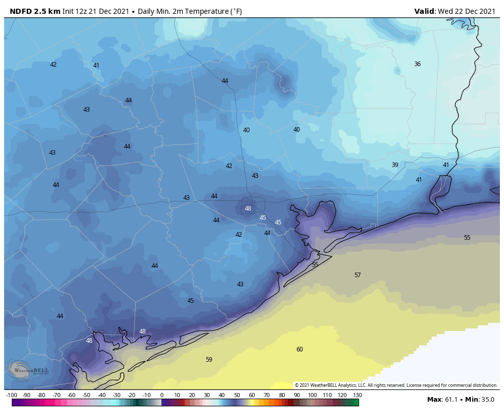
Your low temperatures for Wednesday morning. (Weather Bell)
Wednesday
Skies should still be mostly sunny on Wednesday, and highs will reach about 70 degrees. Winds will be out of the south at around 5 mph. Lows Wednesday night should be in the 50s across Houston, except for the coast which will be a bit warmer.
Thursday and Friday
The warming trend continues, with a pair of mostly sunny days and highs on Thursday in the mid-70s and approaching 80 degrees on Friday. Overnight lows will be solidly in the 60s.
Christmas Day
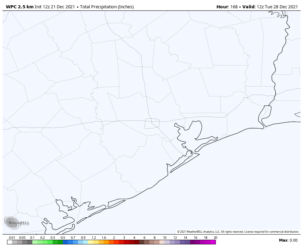
Expect more of the same: Saturday should see mostly sunny skies and high temperatures in the low 80s. Yule not need a log on the fire, that’s for sure. The good news is that rain chances are basically zero.
NOAA rain accumulation forecast for now through Monday. So yeah … dry. (Weather Bell)
Sunday and beyond
Sunday and Monday should see more warm conditions, with partly to mostly sunny skies and high temperatures in the vicinity of 80 degrees. I’d say there’s maybe about a one-in-three chance that a front makes it through around Tuesday, and if not then, a much higher chance a stronger front arrives on New Year’s Eve or New Year’s Day. This front has a chance to drive lows into the 30s in Houston, but since it’s 10 days away we’re basically in the arm-waving portion of the weather forecast.
Good morning. Low temperatures are generally in the 40s right now across the Houston metro area, and this is what a “normal” late-December day should feel like. (The 30-year average temperature for Houston is 44 degrees on December 20). The region will see two more winter-like mornings before we start a warming trend back toward something that is decidedly not normal. In fact, after the brief hiatus of winter-like weather to start this week, the remainder of 2021 looks exceptionally warm. More on this below, along with our Christmas Day forecast.
Monday
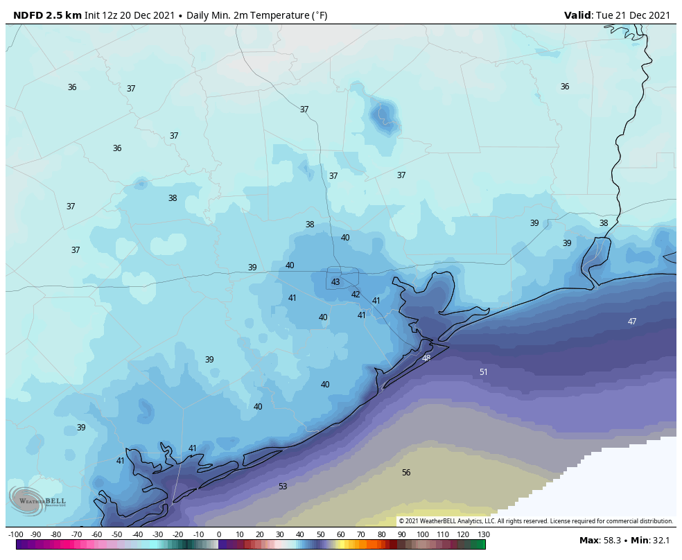
A light, misty rain moved through the region overnight, dropping about one-tenth of an inch or less. This system has now moved east of Houston, and we should see some breaks in the clouds later this afternoon. It’s still going to be chilly however, with highs likely topping out in the mid-50s for most areas. With clearing skies after sunset, this should be the coldest night for the rest of the year, with temperatures in the low 40s in Houston, and upper 30s for areas further inland.
It will be cold (for Houston) on Monday night. (Weather Bell)
Tuesday
This should be a clear, cool, and fine day with light northerly winds and sunny skies. Expect high temperatures to reach about 60 degrees. Overnight lows will probably be a few degrees warmer than Monday night, but still properly chilly for December in Houston. If you like winter-like weather, you would do well to soak up these conditions.
Wednesday, Thursday, and Friday
These should be partly to mostly sunny days, and will see a general warming trend. Expect upper 60s on Wednesday, mid-70s on Thursday, and highs of around 80 degrees on Christmas Eve. Overnight lows by Friday morning will be back into the 60s, with dewpoints to match. Rain chances are effectively zero during this period.
Christmas Day
Our confidence in this period is reasonably high because as a light onshore flow returns during the latter half of this week, it will return us to a familiar pattern. Christmas morning should start out in the 60s, and fog will be a possibility—hence the need for Rudolph and his nose. High temperatures will probably get to about 80 degrees, with partly sunny skies, and then we’ll be in for another warm night. Rain chances are near zero. Yes, this forecast is still five days out, so things could always change. But the fact is, they’re unlikely to. And if you’ve been paying attention to our weather this month, except for the brief interregnums following cold fronts, you know what to expect.
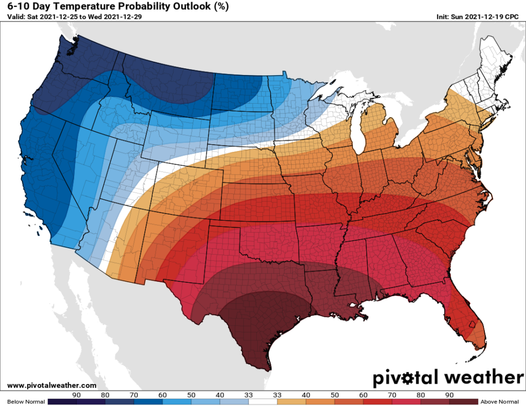
The week after Christmas? Welcome to July-mas, Texas. (Pivotal Weather)
Sunday and beyond
At this point, by far the most likely scenario for next week is a continuation of our warm and muggy pattern, with highs around 80 degrees, and overnight lows in the 60s. Overall rain chances look low through at least the early part of next week. As for our next front, who knows? The next real signal in the medium-range models shows something perhaps around New Years Eve.
The bottom line: Wear your ugly Christmas sweaters today and Tuesday.
Good Saturday morning to you. We’re giving you a bonus weekend post to just give you a head’s up about today’s storms possibly packing a little more punch than expected.
Houston set another record high yesterday at 82° at both IAH and Hobby (tied). The atmosphere over Southeast Texas has atmospheric moisture available that is more typical for August or September than December, particularly south of I-10. When you combine that with wintertime meteorological dynamics and a cold front, you can produce some heavy rain and strong storms.
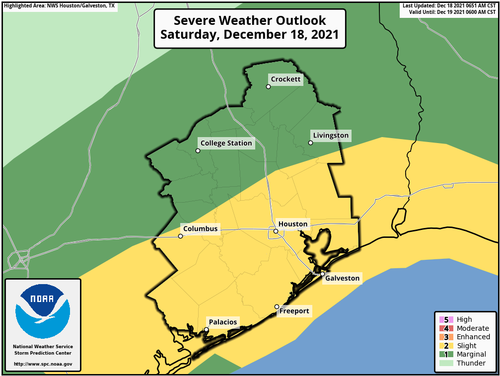
As a result, the Storm Prediction Center has nudged up our storm risk today to “slight,” which is level 2 of 5 on their scale.
Much of the Houston area, especially south and east of the city is in a slight risk (2/5) for severe weather today. (NOAA)
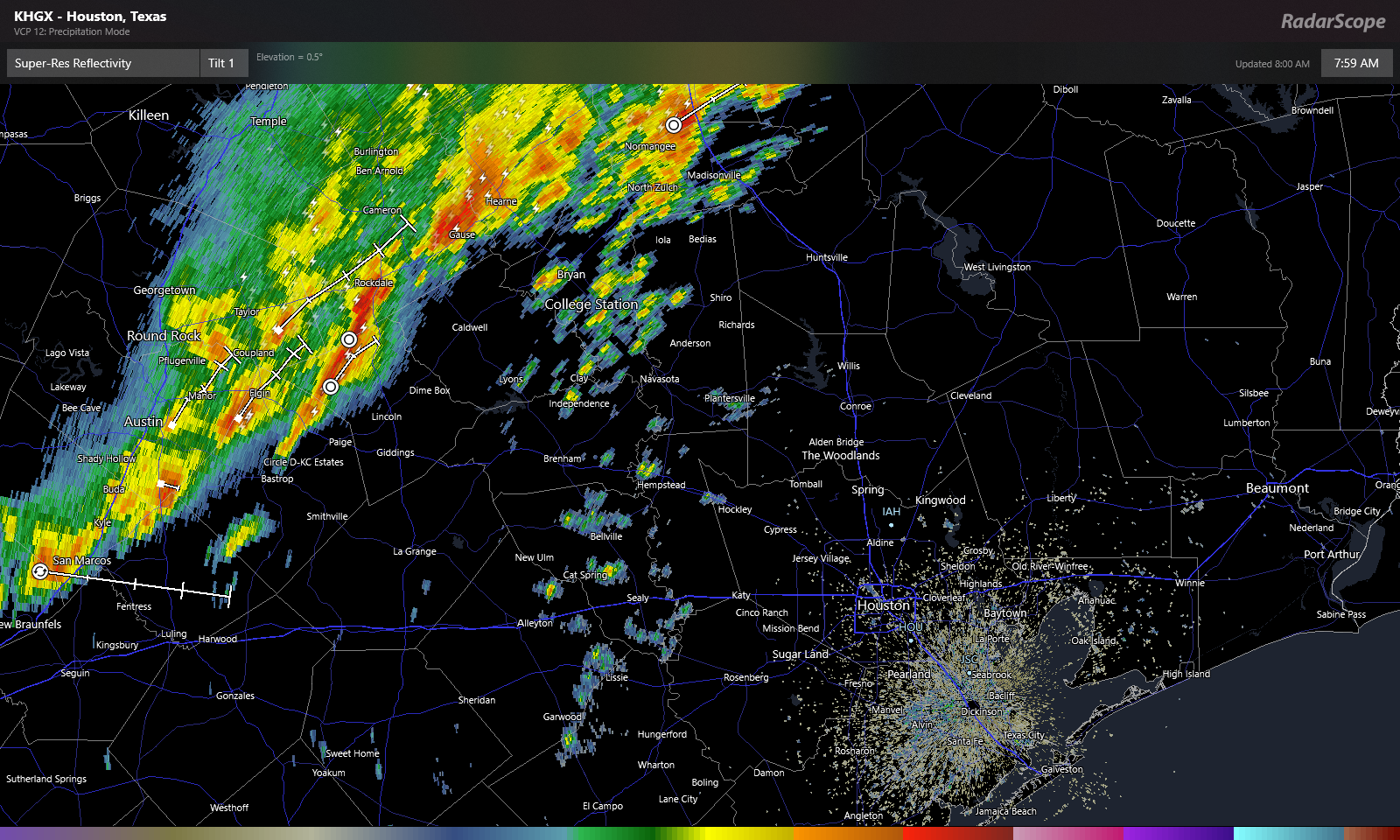
As of 8 AM, the main line of storms associated with the cold front is just approaching the Bryan-College Station area. However, there are showers “front running” the main line. Some of those could strengthen as we warm up a couple degrees this morning.
Radar as of 8 AM shows the main line of storms west of Houston, but some new showers and storms developing out ahead of that line (RadarScope)
So, for today expect scattered showers and storms to develop in the Greater Houston area between now and 11 AM. Any storms that develop do have the ability to become strong to severe. The main threat from storms today will be strong, gusty winds. Hail is possible south of Houston as well, closer to Matagorda Bay. The tornado threat today appears fairly low, but you can never entirely rule one out in these scenarios. Expect the main rain event to move in around midday, pushing south and east through the afternoon. Conditions should improve after 1 to 3 PM as most of this pushes offshore or into Louisiana.
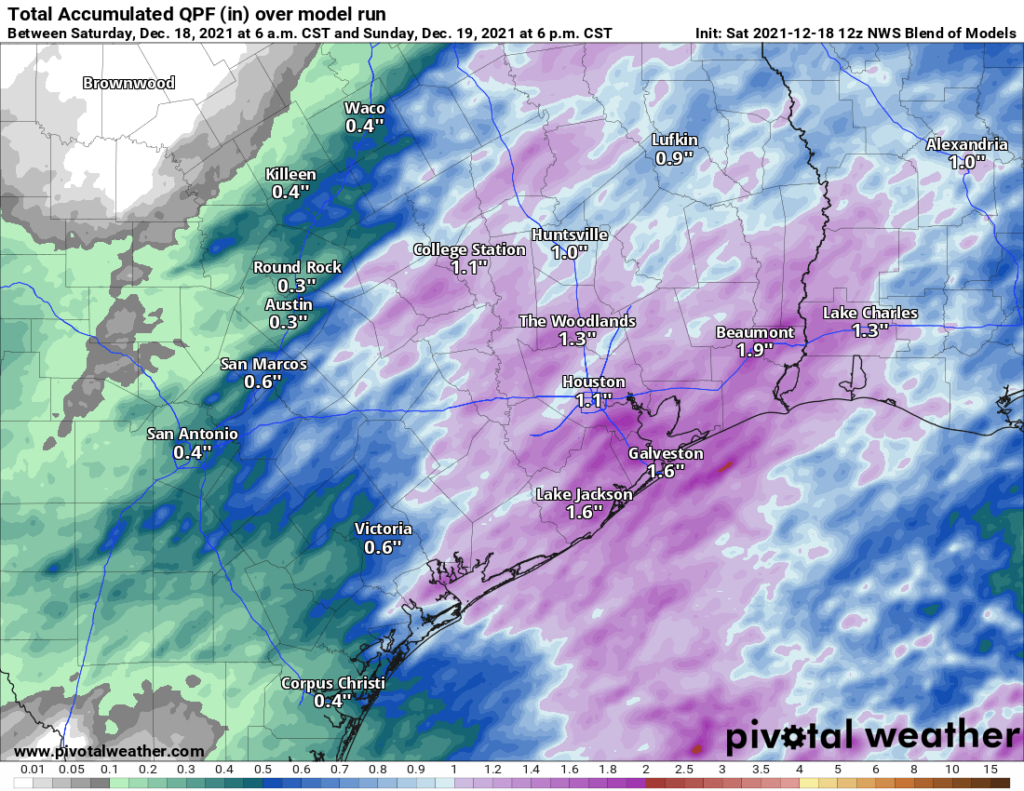
In addition to the chance of some severe weather, these storms will be capable of producing very heavy rain for a short time. We should see 1 to 2 inches on average, though that may vary a good bit from place to place, with some seeing a bit under an inch perhaps. Regardless, some localized street flooding and areas of ponding are likely today.
Rain totals of 1 to 2 inches are possible today as the showers and storms push through. (Pivotal Weather)
Bottom line: Have a way to receive weather warnings today, just to be safe. Storms could be strong to severe, particularly from 10 AM to 2 PM. Heavy rain is likely in spots, and some localized street flooding can’t be ruled out.
The rest of the forecast from Friday is mostly unchanged. We just wanted to re-emphasize the storm risk today. Stay safe, and try to enjoy the day.
Let’s start today’s post with some numbers as of yesterday, the 16th of December.
68.4°: The average temperature for December so far in Houston, a record for the warmest first 16 days of the month. 11: The number of 80° days recorded at Hobby Airport so far this December. (tying a record; it should be broken today) 9: The number of 80° days recorded at Bush Airport so far this December. (the record should be tied today) 5: The number of record warm low temperatures set or tied in Galveston this month.
Yes, it has been the warmest start to December on record in Houston. That doesn’t necessarily mean it will finish as the warmest December in our recorded history, but clearly this is an abnormal month. If you’ve had enough, you’ll get a chance to enjoy cooler weather beginning tomorrow. If you want more of this, there is a non-zero chance you’ll have an opportunity for that again in about a week.
Today
We have some dense fog across parts of the area this morning, particularly near the bays and Gulf and in the outskirts of the suburbs. Look for clearing this morning, and that will likely lead to one more day of low to mid-80s across the area with very high humidity.
Another day of 80s for inland locations today, as more records are likely to fall or be matched (Weather Bell)
Records today are 81° at Bush, 82° at Hobby, and 77° at Galveston. All three seem likely to be tied or fall.
Saturday
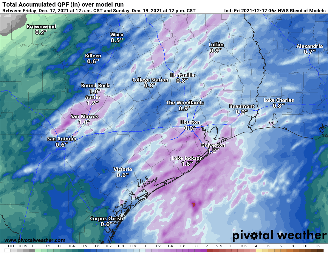
For those of you planning something outdoors on Saturday, the news is not great. Rain should develop in the morning, possibly heavy at times and accompanied by thunder. Rain will likely shut off from northwest to southeast through the early to mid-afternoon. We may manage a dry stretch after 3 PM. This will be especially true north and west of Houston. How much rain are we expecting?
Rain totals should average a half-inch to inch, though some areas could see well over 1 inch of rain when all is said and done Saturday night. (Pivotal Weather)
We should see on the order of a half-inch to an inch of rain across the area, welcome moisture for an area slowly trying to nudge into drought. Some areas will see more than that, however. An isolated strong to severe storm cannot be ruled out either, particularly from Houston south and east.
The front should get through the northwest suburbs of Houston by mid to late morning, the central part of the area by midday and the coast by early afternoon. Temperatures will drop from the 70s into the 60s, if not the 50s as the front passes, and they’ll stay there or slowly drop off a few more degrees through the day. In addition to cooler temperatures, a brisk north wind gusting to 20 mph or so will add some chill to the air.
Sunday
We’ll likely see a mix of clouds and sun on Sunday with temperatures warming from the 40s into the 50s, maybe upper 50s to near 60 with enough sunshine. It will remain at least a little breezy on Sunday.
Monday
A weak system will pass to our south Monday morning, perhaps passing close enough to deliver a few showers or even a rumble of thunder to the area before skies clear out late. The best chance for showers will be the closer you get to the coast. Look for morning lows again in the 40s with highs likely only at best in the mid-50s, possibly even a bit cooler.
Tuesday through Thursday
Look for very nice weather for the middle of next week. Both Tuesday and Wednesday should be partly to mostly sunny. High temperatures should be in the 60s after morning lows in the 40s. Tuesday morning could even see some 30s in spots. Onshore flow should begin to kick back in on Thursday, but we’ll likely see a mix of sun and clouds and lower 70s with morning lows in the upper-40s and 50s. If you’re looking for some optimal holiday-ish weather for Galaxy Lights, Zoo Lights, Lightscape at the Houston Botanic Garden, or just walking around the neighborhood, you’ll have it here.
Christmas Eve & Christmas Day
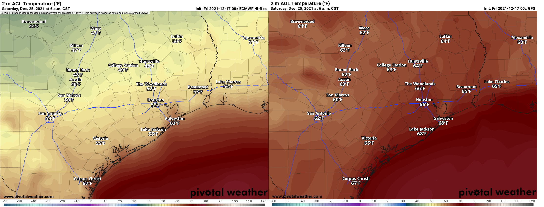
Based on the best available modeling to us today, we have a cold front that will at least flirt with us on Christmas. There remains a very wide spread in possible outcomes. If you compare just the Euro and GFS operational models this morning, you get about a 15 degree spread in temperature outcomes for Christmas morning.
Click to enlarge this view of Christmas morning temperatures from the European model (left) and the GFS model (right), fairly wide goal posts. (Pivotal Weather)
Ensemble models don’t offer much clarity, with about 60% of the European ensemble members pushing a front through by Christmas and maybe 5% of GFS ensemble members. So, it will either be pleasantly cool (close to normal) or warm & muggy. One thing we can say with some confidence: It will probably not be truly cold this Christmas.