Houston will kick off 2023 on a very, very warm note

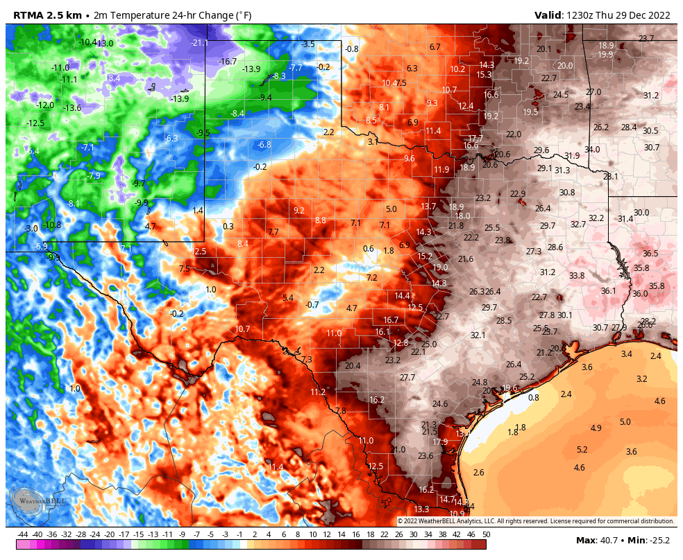
It was 15 degrees in Houston a week ago this morning. We managed 77 degrees yesterday afternoon. The winter roller coaster is here. In addition to the warmth, we saw some pretty gnarly storms over parts of the area, even a Tornado Warning down near Galveston.

Rain totals were highest southeast of Houston, especially in Galveston and Chambers County, which saw 3 to 6 inches of rain. (NOAA NSSL)

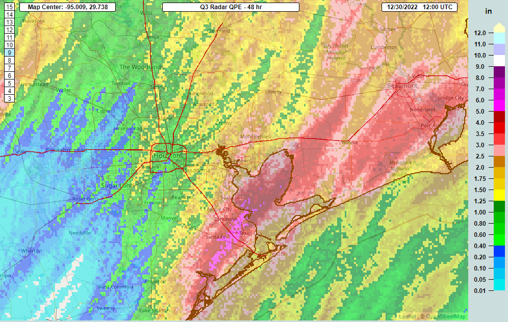
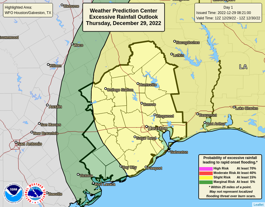
As Eric accurately noted yesterday, the rainfall was quite erratic. Rain totals ranged from over 5 inches near in Galveston County to next to nothing in western Harris, northern Fort Bend, and southern Waller Counties. In between, it was hit and miss. Some areas saw tremendous displays of lightning, while others may have only heard some distant rumblings. So it goes. We’ll settle in to some very mild but fair weather over the next few days before our next speed bump on Monday.

Today

We have a little patchy fog in spots this morning. Other than that, just a lot of clouds. On the whole, we’ll call it “decreasing clouds” with hopefully a bit of sunshine later today. Depending on sunshine, we’ll either hit the upper-60s or low-70s today. Accompanying last evening’s system was a very weak front that will make its presence felt tonight, sort of. Light north winds should allow temperatures to dip into the 50s.

Morning lows on Saturday look seasonable across the area, with most spots in the 50s for the last morning of 2022. (Pivotal Weather)

New Year’s Eve & air quality concerns

We should have partly to mostly sunny skies across the area tomorrow, along with highs into the 70s. All your festivities, from “Noon Years” for those of us with little ones to watch parties for TCU hopefully beating up on the Fighting Harbaughs of Michigan to evening celebrations look great. The only thing to watch will be areas of fog near the coast, so use some caution if you’ll be out and about late Saturday night and after midnight Sunday morning.

One word of caution: Fireworks and air quality.

This forecast sounding (vertical wind, temperature, and humidity profile) for midnight on New Year’s is exactly what we do not want to see with fireworks likely being shot off in droves. Unhealthy or even hazardous air quality is possible early Sunday morning. (Pivotal Weather)

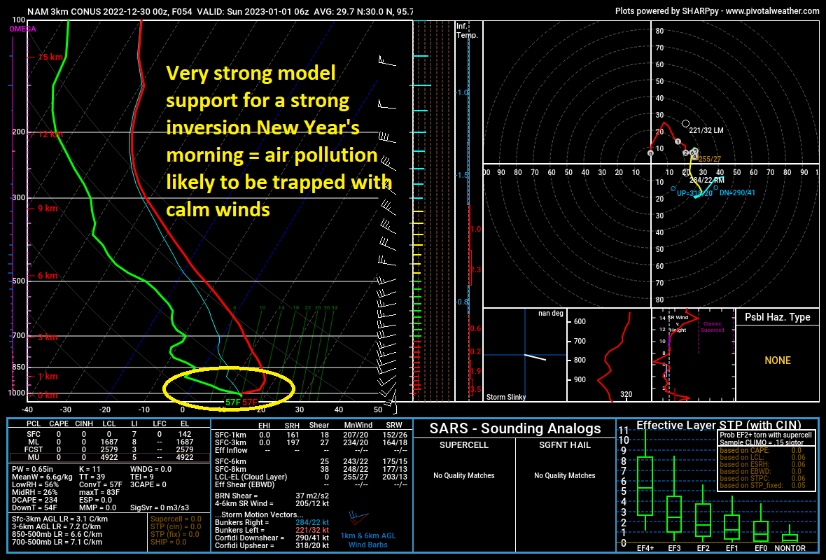
Unfortunately, the setup this New Years is going to be one that features mostly light winds and likely a very strong inversion in the atmosphere. In simple language? All the pollution from those fireworks everyone sets off on New Year’s Eve probably isn’t going to go far, and we are likely in for some very unhealthy, if not outright hazardous air quality across the region at times late Saturday night and early Sunday morning. The good news is that winds don’t look totally calm, but they will be light. So if you have respiratory difficulties, it would be a good idea to keep an eye on area air quality readings. Winds and “mixing” will pick up after 9 or 10 AM Sunday. So if we end up with a lot of trapped smoke in the early morning, the afternoon should at least be nicer.

New Year’s Day

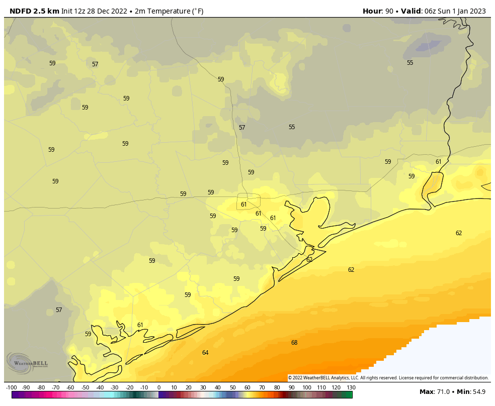
As noted, air quality may be an issue Sunday morning, but at least it should become sunny. Some morning fog is possible, if not likely in spots, and clouds will likely increase through the day. Highs could get to 80 degrees in spots. Coastal areas may again see fog persist deep into the day.

Monday

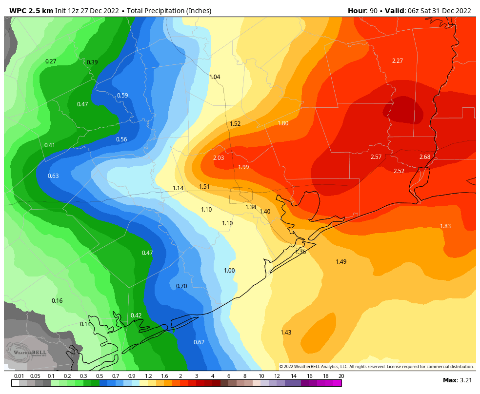
The forecast for Monday continues to look a bit tricky. It may play out very similar to yesterday, with numerous storms, locally heavy rain, and isolated severe weather. Or it could be more widespread. We still don’t have a great handle on this and likely will not until Sunday. Look for an average of a half-inch or so of rain, but it’s likely many places see less and others, especially east of I-45 see 3 inches or more. Highs will top off near 80 in spots, 70s elsewhere.

Rest of next week (and chances of a freeze-peat this winter?)

After Monday’s rain, a cold front and slow clearing should arrive on Tuesday, bringing much cooler weather for Wednesday. We’ll probably drop back to 60s by day and 40s by night for much of the rest of next week. Another warm up is likely late next week or weekend.

We’ve seen a lot of questions about the chances of another freeze this winter. Put simply: We have no idea. There’s no rule that says if you freeze in December like we did this year that it can’t happen again later in January or February. The odds are no different the rest of winter today than they were a month ago. So, yes, it’s possible it could happen again. Likely? Not necessarily. There’s no sign of emergent cold in Canada or the Plains over the next 2 weeks, meaning any strong cold is unlikely here through mid-January. If anything, the jet stream in the Pacific Ocean is trying to ramp up again in mid-January, which could signal another period of warm weather to come. The takeaway? While we see no sign of a freeze-peat right now, that doesn’t mean things can’t change later in January or February. But it’s neither more or less likely than normal because we had one this month.

Happy New Year to you, readers. On behalf of Eric, Maria, Lee, and Dwight, thank you all for a great 2022, and we look forward to another great year in 2023.

Much warmer this morning, with storms possible tonight ahead of a mild New Year’s holiday

Good morning! It is remarkably warmer this morning across Texas and Louisiana, in some cases more than 30 degrees above lows from just 24 hours earlier. Aside from this dramatic warm-up, the big story for the next couple of days is our rain chances later today and tonight, and then mild conditions for the New Year’s holiday.

24-hour temperature change as of Thursday morning at 6:30 am CT. (Weather Bell)

Thursday

Starting with lows around 60 degrees, we’ll warm up into the upper 70s today with mostly cloudy skies. With ample moisture in the atmosphere and an inbound disturbance, there will be a chance of showers and thunderstorms today, perhaps around 50 percent. But the greater chance of storms will come late this afternoon, evening, and during the overnight hours. These storms will be hit or miss, I think, with some areas picking up just 0.25 and inch of rain, but nearby areas seeing 2 or even 3 inches. Areas that see the heaviest rainfall may experience minor street flooding.

Likelihood of excessive rainfall on Thursday and Thursday night. (Weather Bell)

Friday

Rain chances likely end during the pre-dawn hours. A weak front will the slide into the region on Friday, so we likely will see partially clearing skies during the afternoon with highs in the low-70s. Winds will be light, shifting to come from the north. Lows on Friday night will drop into the low 50s.

New Year’s Eve

The final day of 2022 will be a fine one, with mostly sunny skies, moderately dry air, and highs in the mid-70s. Temperatures at midnight will be mild, about 60 degrees, with perhaps a few clouds in the air. Celebrate the new year outside, and safely!

Temperatures as you celebrate the start of the new year. (Weather Bell)

New Year’s Day

The first day of 2023 will be a bit warmer, with highs in the upper 70s to 80 degrees, and partly sunny skies. Lows on Sunday night will only drop into the upper 60s, and perhaps only briefly.

Monday

This will be a wet, and potentially stormy day ahead of another cold front. Details are to be determined, but we’re likely to see 1 to 2 inches of widespread rainfall. The question is whether all of the dynamics in the atmosphere line up to favor severe storms, and for now I think the answer is that such conditions are more likely to the northeast of Houston, rather than over the city itself. We shall see. Otherwise expect highs in the upper 70s.

Rest of next week

Most of next week will probably see highs in the 60s, with lows in the 40s and 50s. There looks to be a fair amount of sunshine as well. So overall, the first week of 2023 looks to be fairly nice. Hopefully one might be able to say that about the whole year.

Holiday lights

We’re in the final days of being able to enjoy the holiday light shows at Space Center Houston and the Houston Botanic Garden. Here’s a review we wrote of these attractions earlier this year. You can find more information about each there, along with a discount code to save you $5 on each ticket.

Get ready to be jacket-free to start 2023

Although it remains chilly this morning across the Houston metro area, with lows in the upper 30s and lower 40s, by this afternoon the last 10 to 12 days of frigid weather will be but a memory. Looking ahead, it probably will be at least a week before we see lows in the 40s again, and there is no likelihood of a return to the 30s any time soon.

Wednesday

Winds have shifted to come from the south, and they’ll pick up in intensity later today, gusting as high as 25 mph. This influx of warmer and more moist air will allow for a mostly sunny and warmer day, with highs in the mid-70s. Low temperatures tonight will only drop into the mid-60s.

Low temperature forecast for Thursday morning. (Weather Bell)

Thursday and Thursday night

Building upon this moist air, an upper level disturbance will move into the region, bringing a chance of widespread showers and thunderstorms. I don’t have great confidence in how this will all play out, to be honest. I expect mostly cloudy skies on Thursday, with highs in the mid-70s. There will be a chance of scattered showers during the day time, but it looks like the more organized activity, if it develops, will do so overnight. There is a slight risk of heavy rainfall for the region, especially for areas east of Interstate 45, and for places like Beaumont and Port Arthur. Although we cannot rule out some isolated street flooding where such heavy rain falls, I don’t expect much of that. Note that these storms could be hit or miss, with some areas picking up less than 0.25 of an inch—particularly the western half of the metro area—and other areas 2 or more inches.

Friday

This should be a mostly cloudy day, with a high in the mid-70s. At some point a weak front will push into the metro area, and this will help to drop temperatures into the mid-50s on Friday night.

New Year’s Eve

This looks like a fine, mostly sunny day with highs in the mid-70s. The front will knock some of the humid air away. Conditions on New Year’s Eve look pleasant, with temperatures around 60 degrees by midnight, and at least partially clear skies. Rain is not a concern for any holiday celebrations. The start of the new year will be, dare I say, mild?

An early look at the temperature forecast for midnight, at the start of New Year’s Day. (Weather Bell)

New Year’s Day

The first day of 2023 will be warm, with highs in the upper 70s to possibly 80 degrees, and mostly sunny skies. Overnight lows will only drop into the mid-60s.

Next week

The combination of more moist air and the next front will produce widespread showers on Monday, which will be another warm day. After that, look for pleasant conditions, with partly to mostly sunny skies, highs of around 70 degrees, and lows of around 50, for much of the week.

Warmer and wetter as Houston looks to close out 2022

Good morning. After about 10 days of much colder weather, Houston will soon return to warmer conditions to end the year 2022. Today, in fact, will be the last chilly day of the year, after which highs in the 70s will persist into early 2023. We also will have two periods of rainfall during the coming week, but I think we’ll manage to squeeze out some fair conditions for the New Year’s holiday in between.

Tuesday

Lows have fallen to freezing, or near freezing, along and north of Interstate 10 this morning, but areas closer to the coast are generally in the upper 30s to around 40 degrees. Skies will be sunny today, with highs in the mid-50s. The most important change will come later today, as high pressure slides eastward, and our winds take a more southerly turn. This will mark a definitive end to the Great Christmas Cooldown of 2022. Lows tonight will drop into the low 40s in Houston.

Behold: Tuesday night will be the last cold one for Houston, in 2022. (Weather Bell)

Wednesday

Skies will be mostly sunny on Wednesday, with highs in the low 70s. Winds will be notable, out of the south at 10 to 15 mph, with gusts up to 25 mph. By Wednesday night we’ll see low temperatures falling just into the 60s, with a slight possibility of some fog.

Thursday and Friday

The end of this week looks wet, as increasing moisture levels from the southerly flow combine with an atmospheric disturbance to produce a healthy chance of rain. These should be mostly cloudy days, with highs in the low 70s. Rain chances look best on Thursday and Thursday night, but a chance will persist through the day on Friday. Overall accumulations look greater for the eastern half of Houston, but I expect much of the region to see at least 1 inch of rain, with some areas seeing 2 or more inches.

NOAA rain accumulation forecast for now through Friday. (Weather Bell)

Saturday and Sunday

Fortunately, it looks like a weak front will clear things out for the holiday weekend. Right now I’m penciling in highs in the low to-mid-70s on New Year’s Eve, with partly to mostly sunny skies, and lows dropping into the upper 50s to 60 degrees by around midnight. Rain chances are pretty low, which is good news for revelers. Skies on New Year’s Day will likely be partly sunny, with highs in the mid-70s. All in all, the turn into 2023 looks fairly mild.

Next week

The weak front won’t last long, and at some point I expect clouds to return on New Year’s Day. This return of moisture will set the stage for another wet period—most likely on Monday January 2, but some uncertainty remains. This could easily bring another 1 to 3 inches of rain to the region before a front brings some moderately cooler and drier air into the region.