Here’s what to expect, and when to expect it, from this week’s hard freeze in Houston

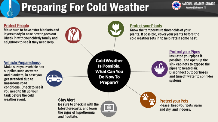
Good afternoon, everyone. We are now only about four days from the start of a massive chill down that will plunge the Houston area into a deep freeze. The forecast has not changed substantially since Matt’s update on Saturday, but we wanted to provide you with the latest thinking we have on timing and intensity. The bottom line is that we all need to be prepared for a hard freeze, and this includes taking the following precautions:

  • Pipes and plumbing: Exposed pipes and plumbing needs to be winterized to prevent damage. Sprinkler systems should be shut off and drained. If you will be leaving Houston for the holidays, you should consider turning off the main water supply in case the pipes in your home burst.
  • Outdoor vegetation and plants: It will be difficult to fully protect tropical plants due to the deep nature of this freeze, but providing some cover may prevent them from being killed. Plants in pots should be brought into the home or garages.
  • Pets and livestock: Because the temperatures will be so low, and for many areas will remain below freezing for longer than a full day, animals should be brought into warmer spaces or they may be killed by the cold.

We know that readers have a lot of questions about the ability of ERCOT to keep power supplied to the state given the hard freeze coming into much of Texas. This is beyond the scope of our ability to forecast, but state officials have expressed confidence in the grid, and we do not expect statewide temperatures to be nearly as cold as experienced during the Valentines Day freeze of 2021. So things will probably be OK. But we can offer no guarantees.

Temperatures will fall off a cliff on Thursday evening. (Weather Bell)

Monday, Tuesday, and Wednesday

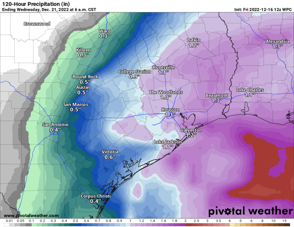
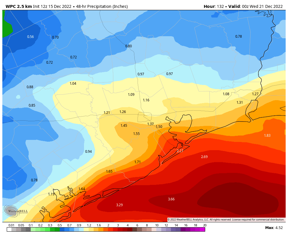
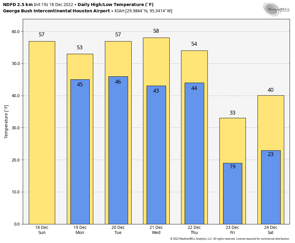
We will continue to see high temperatures in the 50s this week, with nighttime lows generally in the 40s. The big story for the start of the week is widespread rain showers on Monday, which will probably bring 0.5 to 1.5 inches of rain to much of the area. It looks like these will be primarily daytime showers, with chances ending around sunset or shortly thereafter as the disturbance pushes off to the east. After Monday, we can expect mostly cloudy skies to prevail until Thursday.

Thursday

On Seinfeld, Frank Costanza created the “holiday” of Festivus to be celebrated on December 23. Among the holiday’s activities was an “airing of grievances.” Well, on Thursday we’re going to get an airing of frigidness. Daytime highs may get into the 60s or possibly even 70 degrees near the coast on Thursday ahead of the front, which will sweep through the region rapidly from northwest to southeast. In terms of timing, I think late-afternoon is most likely for the front’s passage, but some wiggle room remains.

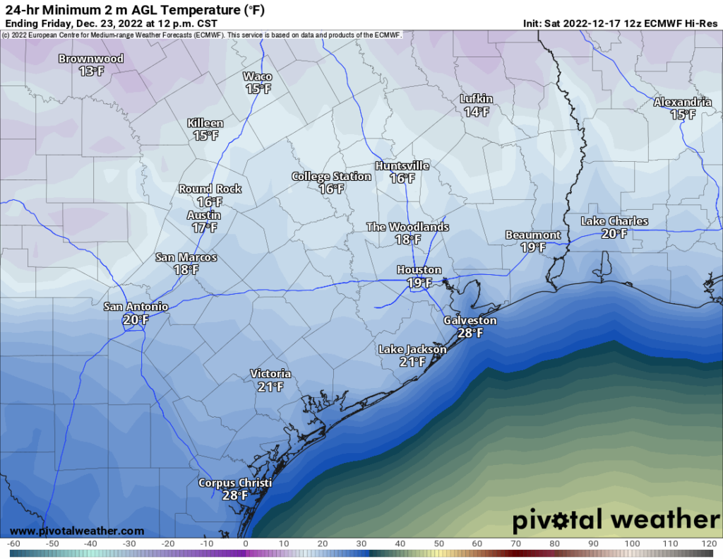
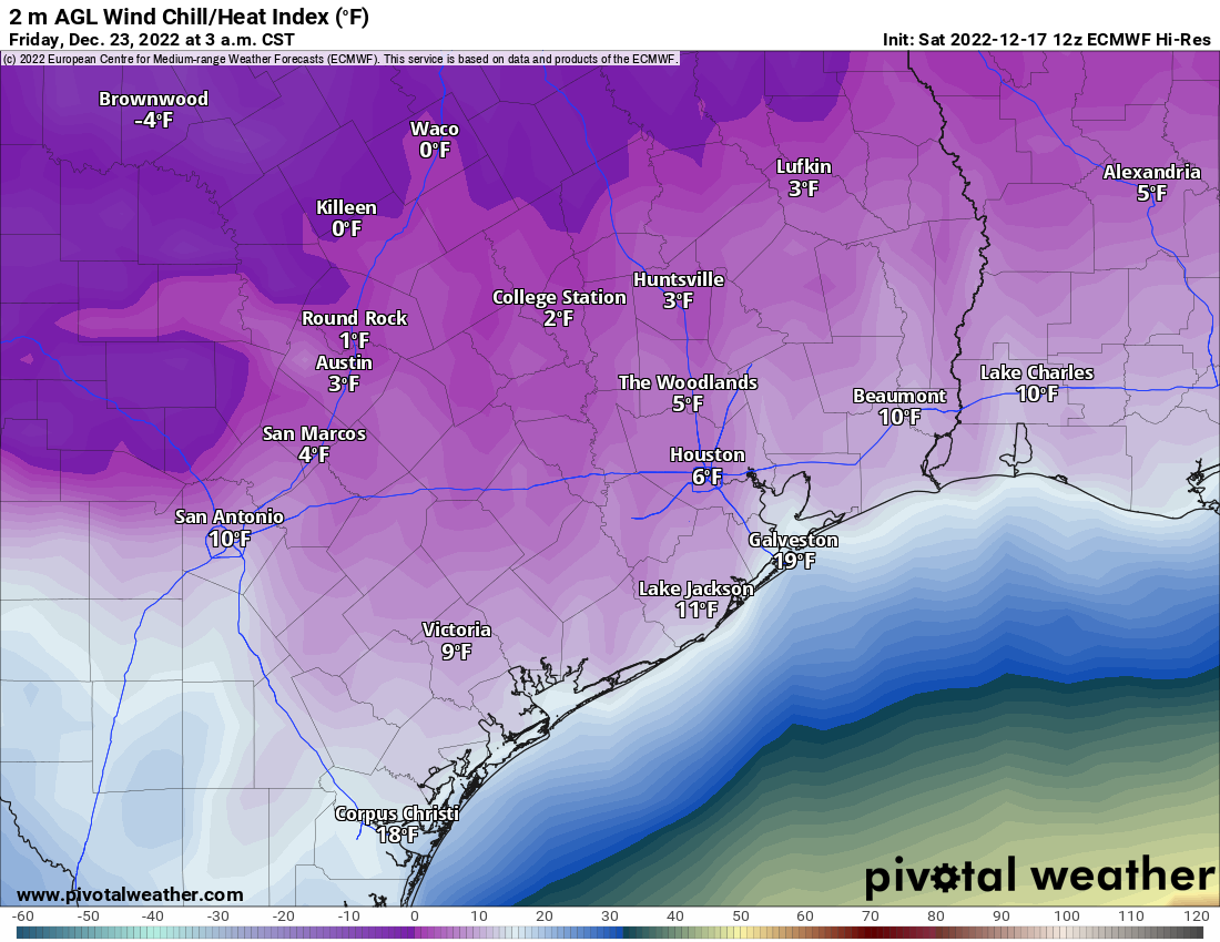
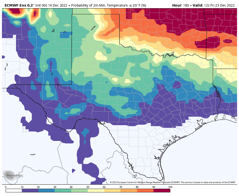
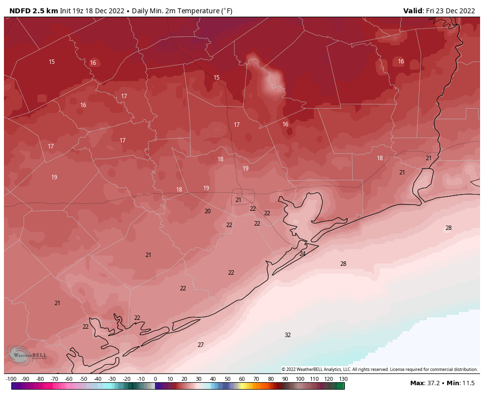
After the front’s passage temperatures will drop into the 30s quickly, with very strong northerly winds, perhaps gusting up to 35 or even 40 mph. While precipitation is probably not a concern, these winds will very quickly sap any heat if you are out of doors. Conditions overnight on Thursday are just going to be nasty outside. Temperatures will bottom out on Friday morning across the region. I think it is possible that even areas south of Interstate 10 briefly drop into the teens.

Forecast low temperatures for Friday morning. Subject to change. (Weather Bell)

Friday

This will be a very cold day. It is possible that some areas reasonably close to the coast will briefly climb above freezing, but much of the metro area is going to remain in the upper 20s to 30 degrees despite sunny skies. Lows on Friday night will still be very, very cold, but should be 3 to 5 degrees above those on Thursday night.

Saturday

Christmas Eve will start out freezing, but with at least partly sunny skies daytime temperatures should reach the mid- to upper-30s for all but far inland areas. We can’t entirely rule out some light precipitation, but right now this period looks dry. This should make holiday travel across the region, and much the state, easier.

Christmas Day and beyond

After yet another freeze, Christmas Day should see highs in the 40s. It will be almost balmy!

Right now most of next week should bring a warming trend, with highs eventually climbing close to 70 degrees by Wednesday or so.

A Saturday update on the growing potential of a hard freeze for the Houston area next week

Good afternoon. Eric and I felt it was a good idea to post an update today on the growing potential that a hard freeze will impact Houston later this upcoming week. Since yesterday, there have been a handful of changes. I will admit that the behavior of yesterday’s front (somewhat stronger and faster than expected) factored into some of this thinking. Sometimes we refer to this as “recency bias,” but truthfully, sometimes the atmosphere can offer up some hints to help us as forecasters.

Bottom line: Temperatures are going to absolutely plummet Thursday afternoon, likely from the 60s or 70s into the 30s over the course of about 4 to 6 hours. We will drop below freezing Thursday afternoon or evening and may not get back up above freezing until Saturday. Overnight lows Thursday night into Friday will likely drop into the teens or low-20s for the city of Houston and most surrounding areas away from the immediate coast. In addition, potent northerly winds will create dangerous wind chill values in the single digits from Thursday evening through Friday morning. We do not expect any snow or ice at this time, a key difference from February 2021, in addition to the intensity and duration of cold.

Friday morning’s forecast low temperatures from the European model are definitely cold, not nearly to the extent of February 2021 on a Texas-wide scale, but cold enough to damage plants and exposed pipes. (Pivotal Weather)

Preparedness

A few thoughts on preparedness for this event. The duration of this cold, the lack of snow and ice, and the intensity of the cold statewide will still lag February 2021, so at this point, we’ll take ERCOT at their word that grid conditions should be manageable. Still, having a winter preparedness kit at the ready is never a bad idea.

This will be a painful freeze for plants, especially given the wind that will accompany the cold. Make every effort to ensure that any tropical plants are protected and as secure as possible, as the wind will be enough to dismantle any weak, unsecured covering.

If you have one, make sure your irrigation system is protected, drained, and turned off.

If you are leaving town late this week, it would be a good idea to consider turning off the main water supply to your home before you go out of an abundance of caution.

Any winterization you can do this weekend or before you leave town is good and will help. If we end up 5 degrees warmer than forecast, great. Please don’t forget pets, livestock, and any folks you know that are extra vulnerable to cold.

Some winter preparedness tips from the National Weather Service (NWS Houston)

Again, this is different than February 2021’s event and should not be quite as bad, but it will be able to cause problems of its own.

Sunday through Wednesday

The forecast is mostly unchanged from yesterday. We expect widespread rain Monday and lingering showers into Tuesday morning. Wednesday should be fine.

Thursday and Friday

The exact timing of the cold front is impossible to pin down right now. Most models point to late afternoon, and given the potential “stronger, faster” behavior of the front, I would lean toward late morning or midday in Houston proper, sooner north and west, later south and east. While we cannot say exactly what the temperature drop will be behind the front, it easily looks to be 30 to 40 degrees colder over a very short period of time. If you are working Thursday, be prepared for a completely different kind of weather when you leave work than when you go to work.

The good news is that this looks like a dry front, so we do not expect rain, snow, or ice. That helps differentiate this a lot from February 2021, when it was impossible to even travel due to ice and snow.

The bad news is that this will be accompanied by wind gusts of 20 to 30 mph or even stronger. That, plus the combination of plunging temperatures will make Thursday night and Friday morning dangerously cold outdoors. Look for lows in the upper teens to low-20s. We could nudge things up or down from here as we get new data in the coming days.

Wind chill values (shown here from today’s European model) are likely to be in the single digits late Thursday night and Friday morning, dangerously cold for being outdoors in Houston. (Pivotal Weather)

The good news is that Friday should be sunny. The bad news is that we may be lucky to reach 32 degrees. The sun will surely help matters on Friday, but it will be deceptive and remain very, very cold and breezy through the day. Another night in the 20s seems likely Friday night into Saturday morning. Some models do show high clouds streaming through, which could help keep temps up a bit for night two of the freeze, but it’s too soon to bank on that.

Next weekend

After another cold morning Saturday, we should expect to rise above freezing Saturday afternoon (currently thinking about 35-40 degrees). Lows in the 20s will again be possible Saturday night, though not as cold as Thursday and Friday nights. Sunday should see highs back in the 40s.

It’s too soon to completely rule out the possibility of a system Sunday or Monday that could bring some wintry precipitation to the area, but I will be honest and tell you that our already low odds have dropped since yesterday and Thursday. Alas, despite the cold, as of now we think travel across Texas will be fine through the holiday weekend. We will share more about weather across Texas for the holiday weekend as we get closer. Eric will have the latest on our forecast tomorrow.

A pleasant early winter weekend before a rainy Monday and cold runup to Christmas in Houston

Well, we made it to Friday again. The weather looks quiet this weekend for the most part. Next week is another matter. The main headlines today:

  • A few showers this evening or overnight before a nice weekend.
  • Widespread rain on Monday.
  • Strong cold arrives Thursday or Friday, but just how cold it gets remains elusive. A freeze is likely for most of the area, with a hard freeze becoming possible on at least one night.
  • While we will continue to watch things closely, we do not believe the upcoming cold will rival what we saw in 2021 in terms of intensity, duration, or impacts.

Connect with us!

Before we get into the forecast, I wanted to share that as of Wednesday, Space City Weather is now available in Apple News! So if you are an Apple News reader, you can search for us there or just tap here to get to our landing spot in the app where you can follow us. Obviously, we’d prefer you come right to the site or download our own app, but we’re making an effort to reach people where they are and maybe grab a few new eyeballs in the process.

Don’t forget to share with any Spanish speaking friends or family that we have Maria Sotolongo on the team using her meteorological knowledge and bilingual skills to cross-post our updates in Spanish at Tiempo Ciudad Espacial and on social media! She does great work, and we want that area of our site to continue to grow.

And lastly, our social media pages. We’ll try to adapt as the environment and people’s preferences evolve, but as of today, you can find us here:

Facebook
Facebook (en español)
Twitter
Twitter (en español)
Instagram
Instagram (en español)
TikTok (we’re working on ways to be more active here)

You can also find myself, Eric, and Maria on most of the socials by searching our names.

Today

Alright, on to weather, and it’s a fine, albeit cool morning across the area. Most of us will see sunshine this morning, but look for clouds to roll in as the day progresses. This is ahead of a cold front to reinforce the dry, cool air over the region. Yes, we could see a few showers pop up along the front late this afternoon as it passes through, but I suspect any rain would be brief, and many of us will see nothing at all. High temperatures will make it into the mid-60s. Winds will kick up a bit out of the north behind the front.

Weekend

Saturday will probably start off with some clouds. There could even be a few lingering showers south of Houston, along the coast and down toward Matagorda Bay. I can’t promise that we’ll turn sunny in the afternoon, but the data suggests we gradually will. So hopefully it will be a day of decreasing clouds. It will be cooler and breezier Saturday, with highs in the low-50s and a gusty north wind (especially over the bays and Gulf).

We’ll have what should be our coldest night of this current stretch so far on Saturday night into Sunday morning. Look for 30s in most spots, with low-30s in far outlying areas and notorious cold spots like Conroe.

Sunday morning lows will be our chilliest so far in this stretch, with a light freeze possible well north and west of Houston. (Pivotal Weather)

Sunday itself should be generally sunny and continued cool, though with less wind. High temperatures should reach into the mid or upper-50s. There could be an influx of clouds during the afternoon, especially south of I-10.

Monday

Monday continues to look like a wet day. Expect off and on rain, sometimes steady to heavy in spots. It will add up to an inch or so across most of the region.

Monday’s rain totals will be somewhat unevenly distributed, but expect close to an inch in most of the area, with some seeing a bit less and others a bit more. (Pivotal Weather)

There will be a bit of a spread in temperature on Monday. Warm air is going to try to surge off the Gulf, so coastal areas could poke up above 60 degrees. Inland areas should stay mainly in the 50s, which will feel very damp with the increasing humidity in addition to the actual rain.

Tuesday & Wednesday

The midweek period does not look too bad, so if you’re out getting last minute gifts, it should be fine, aside from all the other people doing the exact same thing. We may have a few lingering showers on Tuesday, along with plenty of clouds. Highs will be in the 50s to perhaps near 60 or so. Morning lows will be around 50 degrees or in the upper-40s.

For Wednesday, I would anticipate some sunshine and probably another pleasant winter’s day with highs in the upper-50s after a morning of 40s.

Late next week/Arctic outbreak

Alright, so we’ve all been talking about this cold coming. And potentially snow! We know that has folks a little uneasy.

Bottom line: We expect at least a couple nights of freezing temperatures late next week, with an increasing risk of at least one night of a hard freeze (< 25°) in Houston. While we will continue to watch this forecast very closely, we do not believe that the intensity, duration, or impacts of the cold will rival what we saw in 2021, which saw mid or low teens for lows. Snow odds are much lower, but not quite zero.

First, the temperatures. Given the many distractions this time of year, and given that you have had over a week’s notice that this a freeze was possible, it is probably a good idea to take a moment this weekend to prepare your home for a potential hard freeze. Not a February 2021 type event. But a couple nights in the 20s and maybe a night in the teens outside the city.

The Texas Tribune published an article with a bunch of winter weather tips last year. Our advice is to use this as a base and take care of as much of the low hanging fruit as you can right now. Irrigation systems, maybe some very sensitive plants, etc.

In terms of specifics, what we’re able to say with some confidence is that “at least” a freeze is likely across the entire area on “at least” a couple nights, and a hard freeze (temps below 25°) is becoming increasingly likely on at least one night next week, probably Thursday night into Friday.

This map shows the probability of temperatures in the teens next Friday morning. For the City of Houston, it’s currently about 10 percent or less. (Weather Bell)

Whether this goes from a more typical once every few year event to something more problematic is still a question. While it’s unlikely that we will get into some more troublesome cold, it would be foolish of us to completely rule it out. The big thing I’m seeing right now is that daytime temperatures are expected to get well above freezing each day, something we did not see in 2021. We will continue to monitor this closely, but given the current low odds of temperatures in the teens and the expectation of above freezing daytimes, we do not believe this will rival 2021’s situation in terms of impacts.

As far as snow? Here is the European model’s interpretation of the chances we get an inch of snow next weekend. That’s about 10 percent. High for Houston, but not exactly anything I’d take Mattress Mack to Louisiana to bet on.

This map shows the European ensemble model’s chance of at least 1″ of snow through the 27th. It remains at 10 percent or less, high for Houston, but still unlikely. (Weather Bell)

That’s where we are right now. If we have any new insights to share, you’ll find a post from us this weekend. Meanwhile, enjoy the weekend!

No high humidity this year as Mother Nature celebrates the holiday season with Houston

Lows this morning have generally fallen in the 40s, which is fairly typical for December. We’re going to see more or less winter-like weather for at least the next 10 days, with the possibility of a light freeze for inland areas on Sunday morning, and colder weather still later next week. It’s really time for that winter coal, y’all!

Thursday

This will be a prototypical winter day in Houston, with highs in the low 60s, sunny skies, and light winds. Skies will be clear tonight, with lows dropping into the mid- to upper-40s in Houston with cooler conditions further inland.

Friday

As high pressure moves off to the east we’ll start to see the return of some atmospheric moisture, and as a result clouds will start to build in during the morning, or early afternoon hours at the latest. Look for highs in the mid-60s. There is a slight chance of some light rain as a reinforcing cool front moves into the area on Friday evening. Otherwise expect lows in the mid-40s.

Saturday

Skies will clear out on Saturday, likely during the morning hours, in the wake of the front. This will be a clear, cold day, with highs likely topping out in the mid-50s. Clear skies and decreasing winds will allow for optimal cooling conditions on Saturday night, and some outlying areas are likely to see a light freeze. At this time I believe the Houston metro area will remain just above freezing, however.

Low temperature forecast for Sunday morning. (Weather Bell)

Sunday

This will be another chilly day, with highs in the 50s most likely. Winds will revert to come from offshore pretty quickly, however, so we’ll start to see some clouds, and by Sunday evening skies should be mostly cloudy. Lows will drop into the mid-40s.

Monday

In response to increasing moisture levels and a low pressure system, we’ll see elevated rain chances on Monday. For most of the area I don’t think the rain will start until at least sunrise, and perhaps a bit later. Accumulations will probably be greater closer to the coast, where 1 to 2 inches is possible, with isolated higher totals. Skies will otherwise be cloudy, with highs likely topping out in the upper 50s.

NOAA rain accumulation forecast for Monday and Monday night. (Weather Bell)

Next week

We’re expecting conditions through the middle of next week to support high temperatures in the upper 50s to low 60s, with overnight temperatures generally in the 40s. The global forecast models are still strongly suggesting that a robust front will arrive with Arctic air around Wednesday or Thursday, causing temperatures to plummet a day or two before Christmas Day. Unfortunately, at this range, we don’t have the greatest of confidence in how cold things will get. The range of possibilities is this: lows might get as cold as the upper teens or they might only drop into the mid-30s. I’d lean toward a light freeze in Houston at this time, but my confidence is not particularly high. There also is a non-trivial chance of snow—at this point I’d give the metro area perhaps a 10 or 15 percent chance of a White Christmas.