In brief: The current storms across the region are behaving more or less as expected, and much of the Houston region is getting a good soaking with no major problems. We see one more wave of storms this afternoon before the front moves offshore.
Houston weather status: It’s raining. And it will continue to do so for several more hours.
We have seen a couple of waves of showers and thunderstorms today, with a pulsing up of intensity followed by a break. This has brought some healthy rain totals, with up to 4 inches over the last 24 hours northwest of Houston, near locations such as Cypress. Most other areas have picked up 1 to 3 inches. Pretty much all of the region’s major bayous and waterways remain within banks, so the issue has primarily been one of brief street flooding.
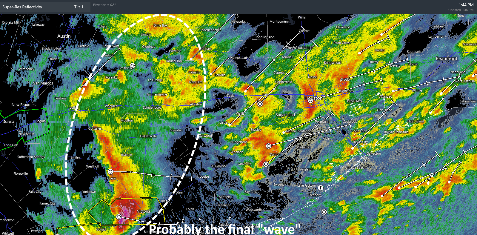
Houston radar snapshot at 1:44 pm CT. (RadarScope)
Based upon radar trends and our most recent high-resolution modeling, it appears likely that one final wave will push through the metro area between 3 and 5 pm, from west to east. This could bring an additional 1 to 2 inches of rainfall for some locations, and we cannot rule out some severe impacts such as damaging winds and possibly hail. As this wave should cross our region during the evening commute, please take a little extra care. After this, from approximately 5 to 9 pm, we likely will see some additional light to moderate showers before the mess moves off to our east.
That will be the end of the rain, but it will be replaced by gusty winds from the north-northeast, up to 30 mph in Houston, and perhaps a bit higher along the coast. These gusts should start to subside on Saturday morning, before dying off during the afternoon hours. The weekend still looks splendid and sunny, with chilly mornings and pleasant afternoons in the 70s. Enjoy!
In brief: Periods of heavy rain will track through Houston throughout the day today, especially along and north of I-10. Additionally, some strong to severe storms are possible this afternoon across the southern 2/3 of the area. Street flooding is a good bet today. Rain ends this evening with gusty winds overnight. But a stellar weekend awaits.
Today
So far this morning, heavy rainfall has been limited to the northern half of the Houston metro, this after some strong storms overnight brought numerous hail reports from Sugar Land through Missouri City and Pearland.
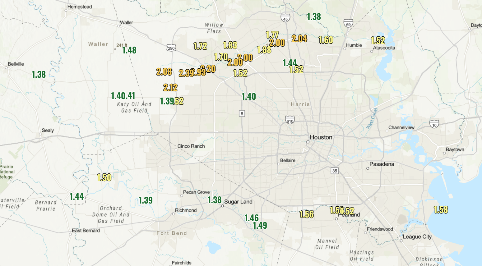
Notable rain totals of around 1.5 inches or more since yesterday, as of 5 AM. (NOAA)
Areas between Cypress and Spring have seen 2 to 3 inches of rain since yesterday. The area that saw hail also received close to 1.5 inches of rain in many spots. Rain continues to jet along and north of Highway 59/I-69 in and west of Houston this morning and north of I-10 east of Houston. That’s going to be the general pattern for most of the day, where those areas see fairly persistent rainfall.
Severe weather risk
However, as we get into the late morning and afternoon hours, there will likely be at least a couple of more ambitious clusters of thunderstorms that develop south of those areas. This would be primarily along and south of I-10 across the Houston metro all the way down to the coast. Not to say we could not see a couple of these find their way north of the I-10 corridor into Liberty, Waller, or northern Harris County, but the severe weather focus today will be mostly south of there. Again, I-10 is not a magical barrier; it’s just a nice, easy demarcation line that most readers generally know.
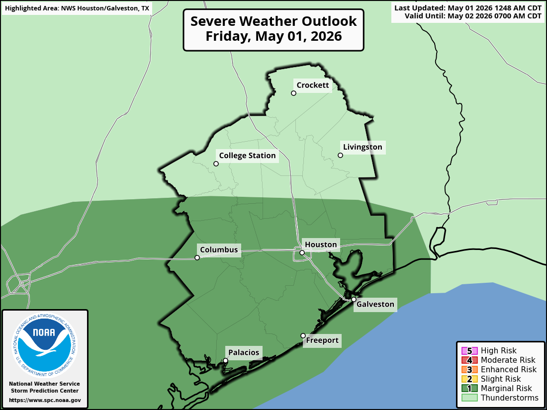
As these storms wiggle through, any of them will be capable of producing 40 to 50 mph wind gusts, some large hail, and frequent lightning. As you get closer to, say, Freeport, Lake Jackson, Matagorda Bay, or as far south as Corpus Christi, there is also a little bit of “spin” in the atmosphere that could yield a storm that produces a tornado, so just be aware of that. The entire southern two-thirds of the area is in a marginal risk (level 1/5) primarily due to the hail risk, but also due to the wind and very isolated tornado risk.
The SPC has the southern 2/3 of the area in a marginal risk (1/5) for severe storms today. (NOAA SPC)
Flooding risks
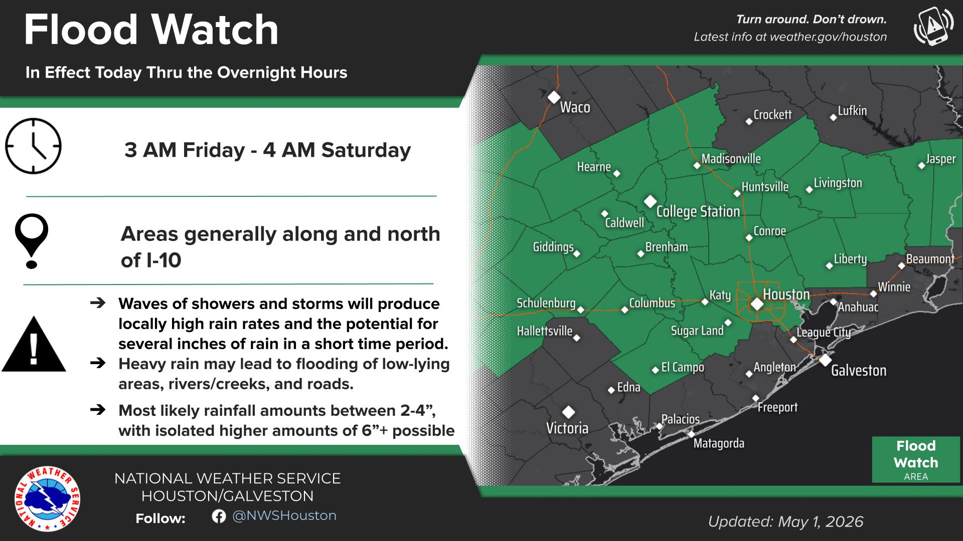
In terms of how much additional rain we see, the entire area away from the coast is under a Flood Watch from the National Weather Service in Houston, a slight risk (level 2/4) for excessive rainfall from the NWS’s Weather Prediction Center, and a Stage 1 Flood Alert here on Space City Weather.
(NWS Houston)
What does that tell you? Street flooding is probably a good bet today. This is a good day to be weather aware if you have errands to run or appointments to tend to. Give yourself extra time to get where you need to go. This will be especially true in the second half of the day as the ground will be saturated, making some street flooding more likely.
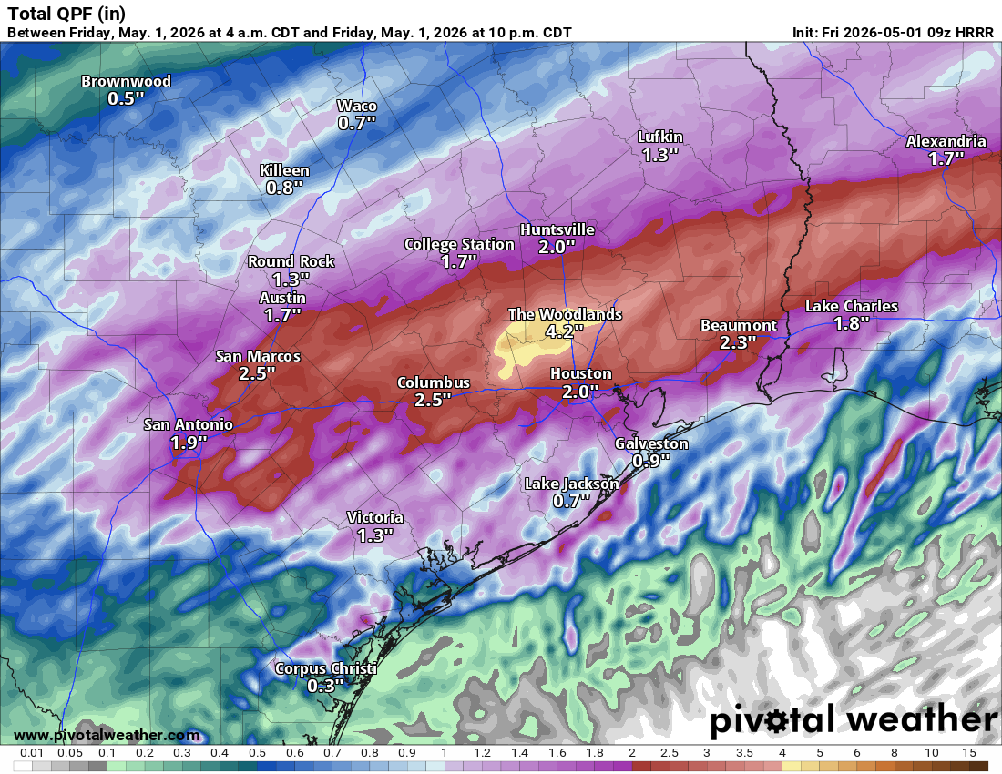
How much additional rain should we expect? It will vary, but likely another 1 to 4 inches of rain through the duration of the event where it’s currently raining (as of 5:30 AM). South of those areas should see anywhere from a half-inch to 2 inches of rain depending on exactly how this afternoon’s thunderstorms align. The latest HRRR model’s depiction of additional rainfall through this evening is shown below. Don’t focus on specifics here, but you can see the general pattern of how things should flow.
HRRR model depiction of additional rainfall today. Don’t focus on specific numbers here, but it should be on the order of 1 to 4 inches north and 0.5 to 2 inches south, with locally higher (and perhaps some lower) amounts likely. (Pivotal Weather)
The good news is that rain should be out of here tonight, so expect the rain to end from west to east from about 8 PM through 1 AM or so. Early evening plans will be dicey, but late evening plans may be ok. Just don’t drive through any residual flooded roads!
Eric will have another update on today’s weather situation by the afternoon.
Gusty winds
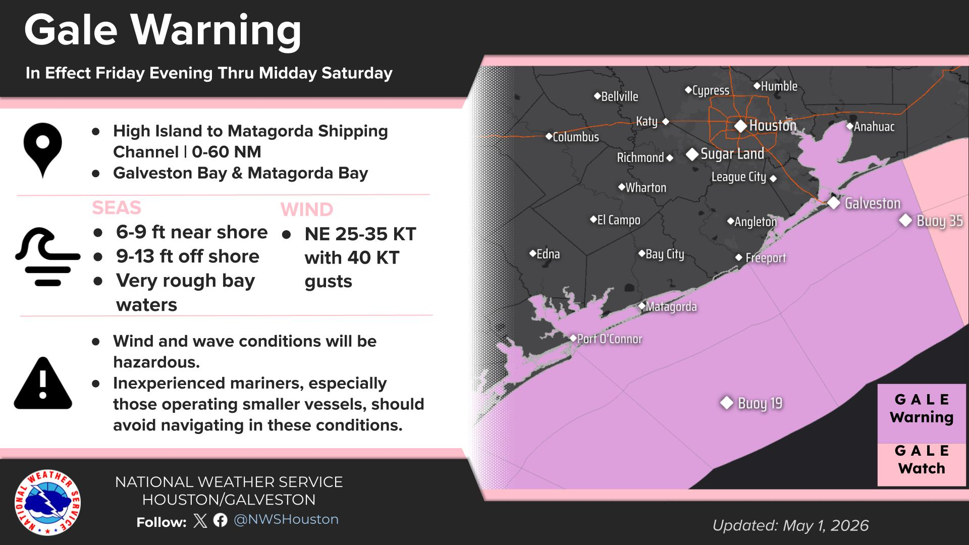
One last note: As the rain begins to wind down, and the front pushes through with the disturbance kind of wound up, we are going to see non-thunderstorm winds increase. This should be especially true near the coast and in the southern half of the area. Inland wind gusts should be on the order of 20 to 30 mph beginning after 6 PM. Some locally higher gusts are possible. Coastal wind gusts will be more like 35 to 45 mph, and gale warnings are posted for the bays and Gulf.
(NWS Houston)
Winds should be at their gustiest from about midnight through 7 AM Saturday. Then, you’ll see them gradually subside through the day tomorrow.
Weekend
Other than the wind in the morning, tomorrow looks glorious with low humidity, sunshine, and highs in the mid-70s. Overnight lows will be in the 50s. Sunday looks just as nice or better with more sun and highs in the upper 70s to near 80 degrees. Enjoy the early May, comfortable weekend spring fling!
Next week
Looking ahead, temperatures do warm up a good bit, back close to 90 degrees by the time we get to Tuesday or Wednesday. Believe it or not, another May cold front may be in the cards for later next week. Details forthcoming on that, but additional rain and storm chances may be in the cards around then as well.