Short on time this morning? No worries. It’s a simple two word forecast the next 3 days: Nice weather.
For those of you that crave details, our analysis, and levity, read on.
Today through Sunday
Well, it certainly has changed a bit since yesterday morning! The map below shows 24 hour temperature changes as of 6:30 this morning, and much of the area is about 20 degrees cooler than Thursday morning.
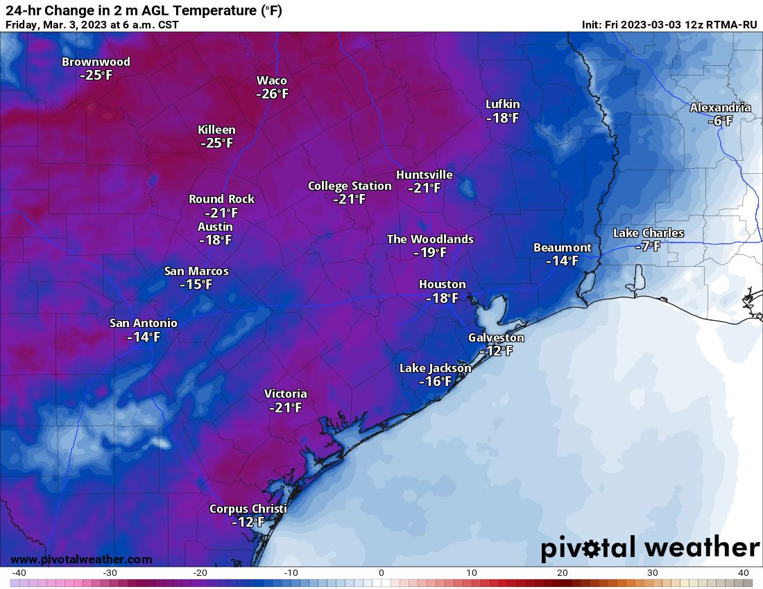
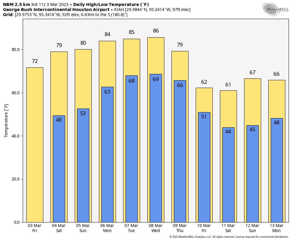
It’s still breezy outside as well, with 20 mph wind gusts in most places, around 30 mph at the coast, and as high as 40 mph offshore. We will get most of the wind out of the system this morning, and this afternoon looks tranquil and mild with highs in the low-70s.
Both weekend days look great. The edge probably goes to Saturday in terms of comfort. Sunday should see humidity inch up a bit later in the day. We’ll have ample sunshine with lows in the 40s and 50s and highs in the mid to upper 70s.

Big weekend at the Houston Livestock Show & Rodeo! We’ve got Bun B’s Southern Takeover tonight, and the weather looks trilling. Temps should be in the upper-60s on the way in and low-60s on the way out. Maybe worth a light jacket for some of you. For Walker Hayes on Saturday, it’s going to be fancy like, with temps in the 70s mostly and perhaps the upper-60s when you’re heading out. Sunday you get the indomitable Zac Brown Band, and you’ll be in the same boat weather-wise with near 80 or so in the afternoon and lower 70s for the evening.
Overall, whatever your plans this weekend, they look great. Unless of course you have pollen allergies, in which case I am sorry. Oak pollen remains through the roof, and there will likely be minimal relief from that for quite some time.
Early next week
As noted above, we do get some humidity back on Sunday. That will transition to a full-fledged face-full of humidity on Monday. Both Monday and Tuesday will feature a mix of clouds and sun with shower chances higher on Monday than Tuesday. We’ll probably top off in the mid-80s, just a touch shy of record highs. Morning lows will be in the 60s to near 70 degrees. Patchy fog is possible, especially at night and in the early morning for coastal areas.
Later next week
Models cannot quite pin down exactly how next week’s front looks. We know a couple things. It’s going to be a strong front in terms of temperatures, ushering in some very chilly air for early March. As Eric noted yesterday, the chances of an actual freeze are quite low at this time, but we’ll continue watching. 40s for lows seem likely at this point by next Friday or Saturday, and 30s are becoming a definite possibility.
Either way, it would appear that the weather is going to change drastically next weekend behind a front that arrives Thursday or Friday. We’ll sort that timing out and get back to you with more on Monday.


Looking forward to getting a lot done outside this weekend. The long range forecast for next weekend looks even better!
I don’t remember my oak allergies being this bad last year. Man. 🙁 But I’ll take the awesome weather and a Saturday off to boot!
Come on out and cheer folks on running tomorrow morning’s 12th annual The Woodlands Marathon, Half Marathon and 10K!
Stellar weekend, love it!
But… Oh lord, cold weather is back next week? Come on… go away!
Lol. You’ll have your 8 months of miserable swamp weather soon enough. Calm down.