Power grid holding as entire state of Texas plunges below freezing

Summary: We’re now in the worst part of this Arctic freeze, when we need to be cognizant of the very cold temperatures and wind chills, some remaining icy spots on roadways around Houston, and the Texas electricity grid. Fortunately the end is in sight, even if the next 24 hours look cold.

First, let’s discuss the forecast, then look at roads and the electricity grid.
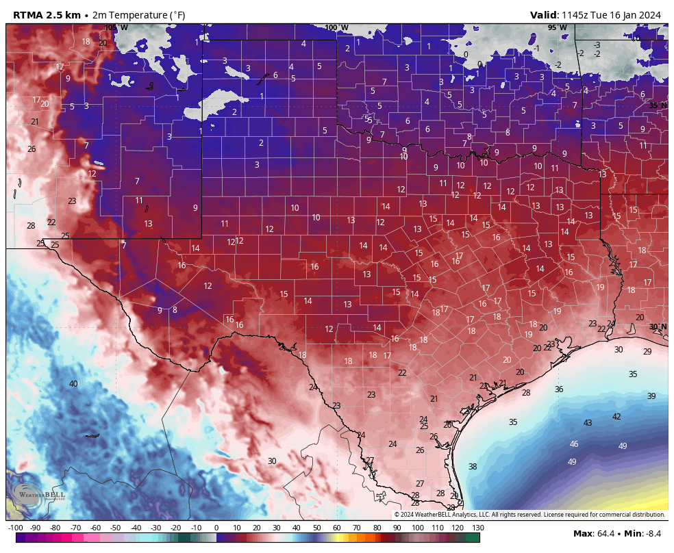
The entire state of Texas is seeing freezing temperatures this morning. (Weather Bell)

Tuesday

The temperature at Houston’s official station, Bush Intercontinental Airport, dropped to 19 degrees this morning (After publication, the temperature fell to 18 degrees at 6:50 am). This set a new record low for today. If you’re wondering how this temperature compares to the Valentine’s freeze in 2021, the lowest recorded temperature then was 12 degrees at Bush. (See lows during that freeze for a bunch of Southeast Texas locations here). When you layer on winds of 15 mph and higher gusts on to these temperatures, it feels like single-digit temperatures outside. That’s pretty brutal for Houston.

Winds will remain up this morning, but should subside some this afternoon finally. We’ll also see clearing skies this morning, which should help the temperatures some. Highs today in Houston should climb above freezing for a couple of hours, but their upper limit is likely mid-30s. Areas further inland, such as Katy and The Woodlands, may only briefly touch temperatures above freezing, or may not make it at all.

Low temperatures tonight should be similar to Monday night’s temperatures. The upside is that with significantly reduced winds, it will feel less cold outside.
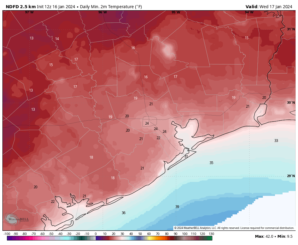
Minimum temperature forecast for Wednesday morning. (Weather Bell)

Wednesday

This will be another sunny day, but some clouds will start to build during the afternoon or evening hours. Temperatures will reach about 50 degrees, with lows only falling into the 40s.

Thursday

This day looks even warmer, if cloudy. Look for highs near 70 degrees. Alas, another cold front arrives later on Thursday to bring another round of rather cold air. Lows on Thursday night will drop to around 40 degrees in Houston, with slightly cooler conditions further inland.

Friday

Winter’s back, baby. Look for highs of around 50 degrees and a cold night. Expect temperatures to drop to around 30 degrees in Houston, so a light freeze is possible for the city. Inland areas may drop into the upper 20s. So maybe just keep your plants covered this week. This surge of colder air won’t be as sharp as the one we’re presently experiencing, but it still will be rather cold by Houston standards. Fortunately there is no precipitation in the forecast during the coldest periods.

Saturday, Sunday, and beyond

The weekend looks cold. Saturday should be mostly sunny with highs in the 40s. A light freeze will be possible for inland areas overnight. Sunday may reach 50 degrees or so with more cloud cover.
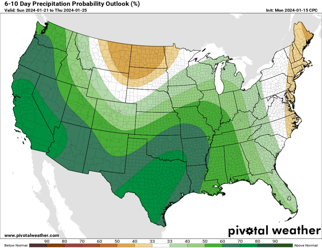
It’s gonna rain in Texas next week. (Pivotal Weather)

After this point we’re going to see a significant pattern change, although the details are still fuzzy. We’ll see warmer weather for awhile, with highs in the 60s or possibly low 70s for most of next week. We’re also going to see the return of some rain showers, possibly a few inches in accumulation starting on Sunday night or Monday. So after the cold, we’re going to get warmer and wet for awhile. I’ve been faithfully placing my orders for days in the 60s and 70s with lots of sunshine this winter, but y’all must be outvoting me.

Roadways

A lot of roads have dried out overnight with the winds. But icy patches remain on elevated freeways and exit ramps and bridges around the region. There are still quite a bit of closures, and travel is inadvisable until later this morning when sunshine and rising temperatures should help to dispatch the ice. You can track icy road locations at Houston Transtar’s website. After today there should be no concerns about winter-related mobility in the Houston area.

Electricity

As of 6:20 am CT, the Texas electricity grid is maintaining between 6,000 and 7,000 MW of excess capacity according to ERCOT. We’re expecting peak demand during the next couple of hours, but given the current capacity it seems that rolling blackouts are unlikely. After this morning, as most of Texas starts to warm up, the grid should have plenty of capacity to cover demand. So, crisis averted.


Sub-freezing temperatures on Monday create road hazards

Summary: Temperatures have trended a bit cooler than expected today, with the freezing line extending all the way down to near the coast. This has caused more problems on area roadways. Elevated highways and bridges, especially, should be treated with caution this evening, and overnight. Tomorrow morning will also feature very cold wind chills, so staying home is advisable, if possible.

Monday night roads

We missed the temperature forecast today by a couple of degrees, but those degrees mattered and led to freezing conditions for most of Houston. With just a couple of hours of daylight left, temperatures are not going up today. Accordingly the freeze line has moved far enough down through the metro are that the light precipitation we’ve been seeing today has caused issues on roadways, particularly bridges and overpasses. This is understandably leading to mobility problems around Houston.

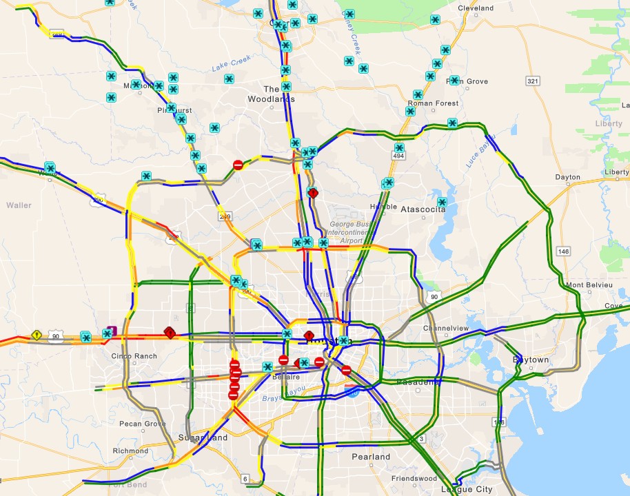
Map of icy roadway conditions as of 3 pm CT. (Houston Transtar)

In particular, an accident on icy roads at Interstate 10 and FM 359 in Brookshire, to the west of Katy, shut down the freeway this morning. With the earlier onset of freezing temperatures in the metro area it is clear that drivers need to take care if they’re going to be out and about today and this evening, especially for areas along and inland of US 59/Interstate 69. Travel northwest of Houston, toward College Station; and north toward Dallas is inadvisable (see icy conditions map).

This light precipitation will clear out of the area later this afternoon and evening, but with a hard freeze setting in—and already there over inland areas where there are already some ice accumulations—it will take some time for the ice to sublimate. How long? That will depend on how much ice there is presently on road surfaces, the effectiveness of de-icing by transportation officials, and sunshine on Tuesday morning. The bottom line is that roads will be potentially hazardous for the rest of today, likely overnight, and possibly into Tuesday morning.

Monday night temperatures

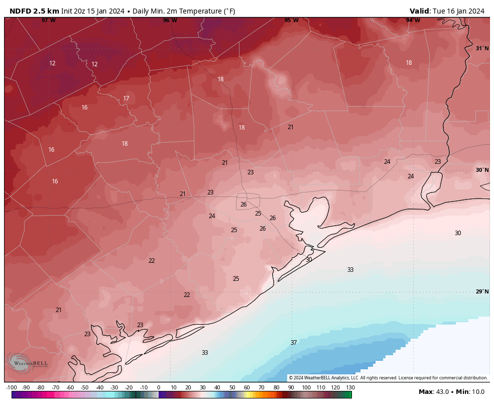
We should see cloud cover for most of tonight, which will help keep temperatures from bottoming out too hard. Winds will be another factor. Paradoxically, winds elevate air temperatures through mixing; but make apparent temperatures feel colder. Accordingly, lows tonight will drop roughly into the mid-20s in the urban core of Houston, with colder conditions expected for outlying areas.

When you tack on gusty winds, up to 20 or 25 mph through the night and into Tuesday morning, it’s going to easily feel like the teens out there. That is not cold to be easily dismissed, and it’s understandable that some school districts have already canceled schools due to the combination of potentially icy roads and very cold wind chills.

Air temperature forecast for Tuesday morning. Wind chill temperatures will be 10-15 degrees cooler. (Weather Bell)

Power conservation

ERCOT has issued another call for electricity conservation on Tuesday morning, during the hours of 6 am to 9 am, due to cold temperatures statewide and surging power demand. The current forecast for electricity shows demand forecast to be higher than supplies during this time frame, so it is possible that we see some rolling blackouts for a couple of hours. It’s something we’ll all be monitoring early tomorrow morning, I am sure.

Tuesday and Tuesday night

At some point on Tuesday morning the skies will clear, and we’re going to see the sunshine. This should help sublimate any remaining ice on the roads in the Houston metro area, even though air temperatures are likely to remain below freezing during the morning hours. Parts of the city near downtown and closer to the coast will briefly climb above freezing on Tuesday. But we’ll cool down quickly as winds die down, and with clear skies overnight. Expect low temperatures to be a couple of degrees colder than Monday night.

By Wednesday morning we’ll be warming nicely, with sunny skies, to daytime highs of about 50 degrees.

A message from Reliant

We’re grateful for Eric and Matt’s dedication to keeping us informed during this wintery weather. When it comes to energy usage during extreme weather, Reliant also wants to help Texans be prepared. With temperatures dipping, Texans may crank up their heaters to stay warm and because many have electric heaters, freezing temperatures could result in increased energy usage and costs. Heating the home can use up to five times more electricity in one hour than the AC does in the summer.

Through a few simple actions, Reliant is arming Space City Weather readers (regardless of their electricity provider) with tips to help save energy while staying warm:

  • Check your thermostat. If you have electric heat in your home, keeping your thermostat around 68 degrees can help you save energy. For every degree above that, you can typically expect a 3-5% increase in heating costs.
  • Let the sun in. When the sun is shining, open blinds and shades during the day to naturally warm your home. Close them at night to help block out the chill.
  • Close heat escape routes. Keep the chimney damper closed when not in use and be mindful of how often you’re opening entry doors and using bathroom or utility room ventilation fans, as heat can escape through these outlets. 
  • Set your ceiling fan to rotateclockwise. This helps force warm air down from the ceiling into the room to create a more comfortable environment. 

For more tips on staying warm while managing your energy usage, visit Reliant.com/WinterTips.

As the freeze deepens, ERCOT asks for statewide power conservation

Good morning. Although the coldest weather for Houston will actually come over the next two nights, much of the rest of Texas is experiencing the lowest temperatures of this Arctic outbreak right now. Because of this, the Electric Reliability Council of Texas, or ERCOT is asking Texans to conserve power from 6 am to 10 am CT on Monday. Expect another call for conservation on Tuesday morning.

The agency has not said whether it will institute rolling blackouts if demand exceeds power reserves, but that certainly seems possible. You can track power grid status in real time, here. Please note that, at this time, there is no reason to believe that we will see extended blackouts like we experienced during the deep freeze in February 2021.

Now, let’s jump into the forecast.

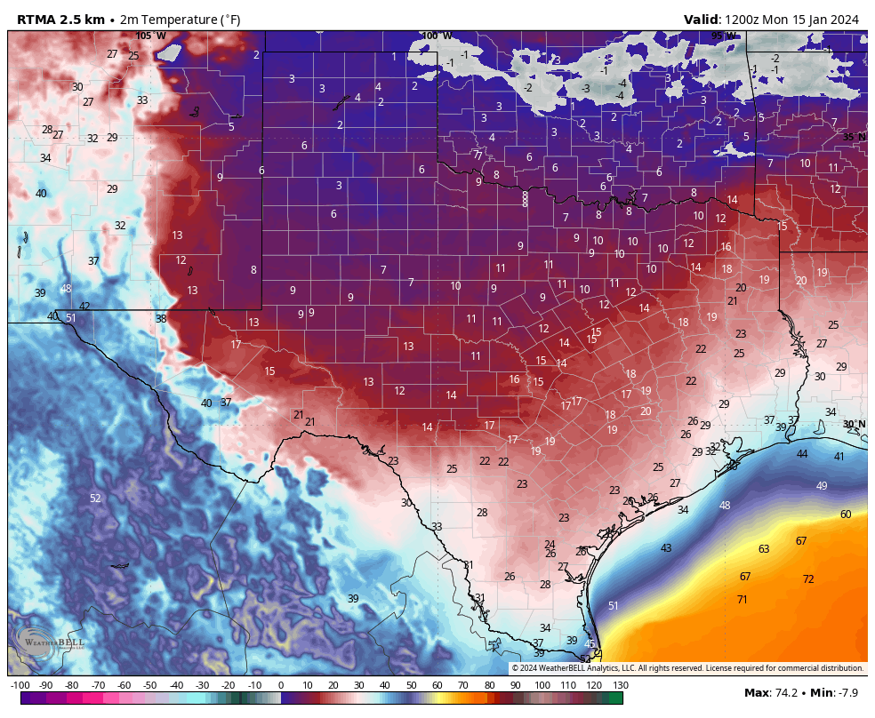
Temperatures as of 6 am CT on Monday were cold across Texas. (Weather Bell)

Monday

We’re starting the new week in a chilly posture, with areas inland of Interstate 10 generally experiencing a freeze. For far inland areas, such as Brenham and College Station, temperatures are already well into hard freeze territory. In Houston’s urban core temperatures are holding at or just above freezing. Arctic air will continue surging into the region today, and temperatures are likely to hover at about freezing levels, or just above or below, for much of the day.

The big question, of course, is precipitation and the extent to which we see freezing rain. We expect to see a mix of very light precipitation and drizzle today in the Houston metro area, with accumulations on the order of a few hundredths of an inch. With temperatures hovering near freezing levels, some of this is bound to fall as freezing rain, leading to concerns about icing on bridges and overpasses. Overall, we don’t anticipate a major ice storm or anything like that in our region, but icy conditions are something to be cognizant of today if you’re out and about. You can check local roadway conditions at Houston Transtar, where icy conditions will be reported. Statewide conditions can be found at Drive Texas. As expected there are a flurry of ice issues well north of the Houston area, particularly around the Dallas area and East Texas. Travel to those locations is not recommended today.

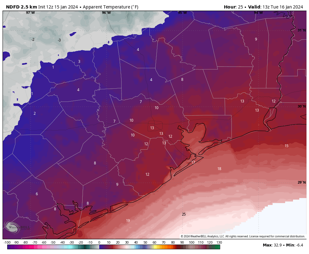
Tonight will be quite cold, especially with a northerly winds of 15 to 20 mph (higher at the coast) piling on wind chill. Air temperatures will drop into the mid-20s in Houston, with colder conditions further inland (a hard freeze) and slightly warmer conditions near the coast. Even Galveston could experience a light freeze. Tuesday morning will feel very cold outside:

Apparent temperatures, which factor in wind chill, will be very cold on Tuesday morning. (Weather Bell)

As for roads, I think the combination of dry air and windy conditions will remove any moisture and ice. So my best guess is that while conditions will be very cold tonight and into Tuesday, roads should be dry. That is dependent on how much precipitation we get today, of course. We’ll update these icy roads predictions later this afternoon.

Tuesday

After the cold start to the day, highs may reach the low- to mid-30s in Houston underneath sunny skies, but those persistent winds will keep a chill in the air. Areas well inland are likely to remain below freezing throughout the day. As winds die down on Tuesday night, we’ll see ideal conditions for cooling. Expect lows to bottom out from 20 to 25 degrees in the urban core of Houston, with colder temperatures inland.

Wednesday

After a very cold start, highs should warm to about 50 degrees on Wednesday with sunny skies. Lows on Wednesday night should remain comfortably in the 40s.

Thursday

A warmer day, with highs in the upper 60s and partly sunny skies. Another fairly robust front arrives on Thursday night-ish, returning colder conditions to the area.

Friday, Saturday, and Sunday

We are going to experience highs in the upper 40s or lower 50s through the weekend, with mostly sunny skies. Lows may reach freezing on Saturday morning in Houston, but it should be a light freeze.

Our best guess on the Arctic front’s impact: Cold, but manageable

Good afternoon. Just a short-ish update this afternoon because, you know, meteorologists want to watch the Texans playoff game as well. Not a whole lot has changed from the forecast we published this morning. So for this post we’re going to summarize the forecast and impacts, and attempt to answer some questions readers have. Be forewarned: We don’t have absolute answers.

Forecast

An Arctic front will push into Houston overnight, likely moving through the downtown area before sunrise, and reaching the coast by sunrise or a little bit afterward. This will not be a ‘blue norther’ front in that while the winds will shift to come from the north, they are not likely to be howling. Temperatures will remain above freezing on Sunday, and should remain at or above freezing for the majority of the metro area Sunday night with the usual exceptions, places like Montgomery and Conroe.

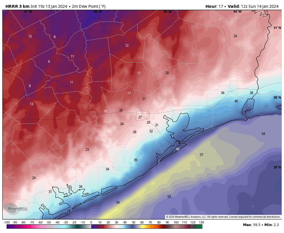
HRRR model forecast for dewpoints at 6 am CT on Sunday morning depicts the front nearing the coast. (Weather Bell)

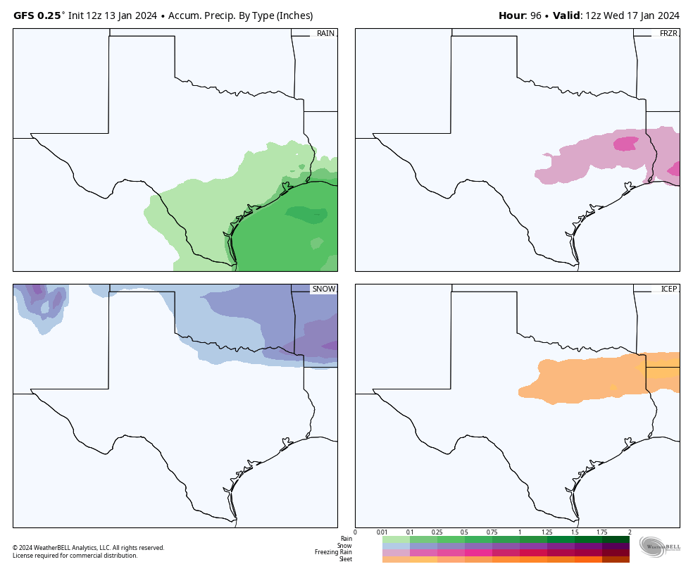
Monday is going to be a cold day. Most of the region will be in the 30s, with mostly cloudy skies. A passing disturbance will bring light, scattered rain showers into the area beginning late Sunday night or early Monday morning. Most of our model guidance still indicates this precipitation will fall as rain in Houston, with a transition to freezing rain northwest of the metro area, perhaps roughly along Highway 105. Bottom line: It’s going to be miserable outside in Houston on Monday, but you should be able to get out and about. We’re continuing to watch the freezing line closely, of course.

A secondary push of cold, Arctic air will arrive on Monday and that will nudge nighttime temperatures lower on Monday night. But there’s still a pretty broad range of uncertainty on how far the mercury drops on Monday night, depending on cloud cover and other factors. Our advice: prepare for a hard freeze in Houston, but don’t be surprised if temperatures are a little warmer. Tuesday night into Wednesday morning continues to look like the coldest night of the forecast period, when much of the metro area will drop into the upper teens to mid-20s. I don’t feel confident putting a finer point on those temperatures yet. We emerge from the icebox on Wednesday.

Now, let’s try to tackle some questions.

Is the power going to go out?

We’re weather forecasters, not power prognosticators, and so we have limited insight. Statewide temperatures do look 5 to 10 degrees warmer than the exceptional cold that led to widespread power outages in February 2021, and the state has invested in “winterizing” the grid in the three years since that disaster. All of that makes us feel pretty good about the state avoiding prolonged outages.

So far state officials have not called for conservation next week. But it seems like that may be possible, especially on Monday and Tuesday mornings, when the demand forecast from ERCOT is near to the expected supply. In any case, we’ll all see what happens together.

Are there going to be Airport delays?

If we get freezing rain at Bush Intercontinental Airport (or Hobby, for that matter) then yes, there could be some significant flight delays on Monday. But that does not seem likely at this time. For the most part this is going to be the story of cold weather rather than a winter storm. The optimist in me thinks that while there may be some airport delays on Monday and Tuesday, they probably will be due to the destination airports rather than conditions at Houston terminals. The pessimist in me is saying, “Uhh, dude, you’re out of your depth here.” Which is true.

Is school going to be canceled?

Monday is a holiday, to mark Martin Luther King Jr. Day. If our forecast is wrong, and we get more rain than expected on Monday, and conditions are a little colder, than we could see some icy bridges and overpasses on Monday night into Tuesday morning in Houston. That would be a reason to cancel schools in the Houston metro area on Tuesday. But right now we don’t anticipate that happening.

We should have even more confidence in the forecast by tomorrow. Tuesday and Wednesday mornings are going to be blustery and cold, with wind chills in the 20s or teens. Is concern about exposure getting to and from school a reason to cancel it? That’s not my call. But at present our expectation is that roads will remain passable during this winter event.

Precipitation, by type, on Sunday night and Monday, as forecast by the GFS model. Note that most of Houston is likely to see plain old rain. (Weather Bell)

Should I drive to Dallas or Austin on Monday?

These are going to be difficult calls. Right now there’s a chance of light, freezing rain on Interstate 10 and Highway 290 on Sunday night and Monday. Will there be enough to stick on highways? Maybe a few bridges and overpasses. But I don’t feel great about making that call on driving to Austin right now.

As for Dallas, or places like Shreveport, I’m a little more confident that we’re going to see some decent freezing rain or sleet accumulations that could make travel hazardous. So if you’re heading north of The Woodlands on I-45, or north of Cleveland on Highway 59 on Sunday afternoon or Monday, I’d definitely check road conditions before leaving.

Is it going to snow?

Yes. But not in Houston. For any appreciable totals, you’re probably going to have to travel to Oklahoma or Arkansas on Sunday or Monday. Which, as noted above, is not advisable.