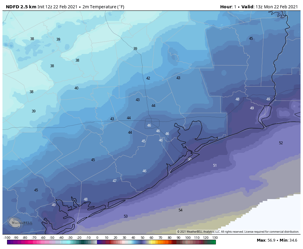
Is Houston actually going to have a winter this year?

Good morning. In today’s post we’ll talk about the weather for the week of Thanksgiving—which should be fairly pleasant for the holiday itself, if warmer than normal—the likelihood of a stronger cold front during the coming weekend, and discuss what our warmish fall may mean for our upcoming winter. Also, I’d like to remind you that we are entering the final week of our annual fundraiser, during which you can support the site through buying merchandise or simply donating. We appreciate the tremendous response so far this year.

Winter is (not) coming?

The Houston region has twice gotten as cold as 42 degrees this fall at Bush Intercontinental Airport, but we have yet to dip into the 30s in the metro area—what I would generally define as “cold” or “winter-like” weather. On the flip side, a lot of nights this month have been quite warm for November, with more than one-third of lows not reaching 60 degrees or below. This rather warm end of fall may make you wonder whether we’re going to see sustained, winter-like weather this season.

I think the answer is yes. This week is, indeed, going to be fairly warm, with highs in the 70s (and possibly 80 for a few locations), and nights will not be cold. But the extended models suggest we’ll enter a much colder pattern by Sunday, and that it’s going to stick around for awhile in December. It is true that we are in a La Niña, a fairly strong one, and this typically means we see somewhat warmer than normal conditions during December, January, and February. However, that does not mean the region will not see nights in the 30s and at least a handful of freezes. So hang on—Houston should start to experience more winter-like weather soon. For some winter energy saving tips please check the message from Reliant at the end of this post.

Yes, Houston is going to see a winter this year. (Weather Bell)

Monday

A weak front has moved into the Houston region during the overnight hours, and it will lead to a pleasant, fall-like day for the region. As drier air filters into the area, we should see partly to mostly sunny skies by this afternoon, and high temperatures will climb into the low 70s for most areas. Winds will be light out of the north, shifting to the east. Lows tonight should drop to around 60 degrees in Houston, with warmer conditions along the coast, and 50s further inland.

Tuesday

Winds will shift to come from onshore by Monday night, and this will set up a warmer, more humid day on Tuesday, with highs of around 80 degrees and partly to mostly cloudy skies. Low temperatures on Tuesday night will be 5 to 10 degrees warmer.

Wednesday

The second front of the week should push into Houston on Wednesday, perhaps reaching western parts of the region during the morning hours, and moving to the coast by noon, or during the afternoon hours. There will be perhaps a 30 percent chance of rain with the front—showers would be brief, and not particularly heavy—before skies clear out in the wake of the front. Highs will likely be in the 70s before overnight temperatures drop into the 50s for everyone in the region except for the immediate coast.

Current forecast for high temperatures on Thursday. (Pivotal Weather)

Thanksgiving

Most of the holiday should see fair weather in the wake of the front, with highs in the upper 70s and partly sunny skies. However, this front will be another short-lived affair, so the onshore flow should resume later on Thanksgiving and lead to a fairly warm and muggy night with lows struggling to fall below 70 degrees for many locations in the metro area.

Friday, Saturday, and Sunday

At this point the big picture for this weekend seems pretty clear: We’ll see clouds and pretty healthy rain chances on Friday and Saturday before a fairly strong cold front moves into the region. But will the front arrive on Saturday afternoon? Or Sunday morning? Right now I don’t know, and that’s going to have a big impact on daily weather conditions. The bottom line is that most of the area should see some much needed rain toward the end of this week—perhaps 1 to 3 inches—before a more winter-like front moves through. We may even finally see some lows in the 30s by the time early December rolls around.

Message from Reliant

A few conscious energy choices can make a big difference in your winter electricity bill. Considering heating and cooling costs account for nearly 50 percent of your electricity bill, increased heater usage can lead to higher-than-normal winter bills — if energy efficiency measures aren’t taken. An annual heater tune-up is recommended to make sure your furnace or heat pump is clean and in good working order, so that it can run as efficiently as it should.

Reliant has a few tips you can do immediately to reduce energy consumption and still stay comfortable. Best of all, they’re simple and free.

  • Let the sun in. Open blinds and shades during the day and remove any solar screens so the sun can warm your home.
  • On vs. auto. Ensure the fan on your thermostat is set to “auto” not “on” to prevent it from running 24/7.
  • Check your thermostat settings. For every degree above 70°, you can expect a 3-5 percent increase in your heating costs.
  • Turn your ceiling fan to clockwise position. By turning your ceiling fan to the clockwise position, you can help force warm air down to create a more comfortable environment in colder seasons.
  • Put your thermostat on vacation mode. Drop your thermostat to 50° if you’ll be gone for a few days or more. This is warm enough to prevent your pipes from freezing and won’t waste energy warming an empty home.
  • Set your water heater to 120°. This is hot enough to be sanitary while saving you up to $60 a year on your heating bill.
  • Use exhaust fans in moderation. Be mindful of how often you’re using bathroom or utility room vents as they can remove heat from your home.
  • Close damper on fireplace. When not in use, ensure the damper on your fireplace is closed so heat does not escape up the chimney.

Sunny and warm weekend, Thanksgiving may see seasonal weather

Good morning. Lows have bottomed out at around 60 degrees this morning, and now we’ll see warmer conditions through the weekend as the onshore flow gets going. Houston’s very, very dry air from earlier this week is now long gone and we’re not quite sure when it will return.

Thursday

Rising moisture levels have led to the formation of some clouds this morning, but skies should clear out some this afternoon, allowing highs to climb to around 80 degrees. Winds will generally be light, out of the southeast. Overnight lows should only drop to the mid-60s for most areas tonight. These temperatures are about 10 degrees warmer than we normally would experience in late November.

Forecast lows for the Houston region on Friday morning. (Weather Bell)

Friday

With light winds, and little difference between dewpoints and temperatures, we likely will see some fog develop on Friday morning across parts of the Houston region. There’s some split in the models, but I think we’ll probably see at least partly, if not mostly cloudy skies during much of the daytime. There is maybe a 10 percent chance of rain on Friday, but don’t hold your breath for a fleeting shower.

Saturday

The first half of the weekend will probably see partly to mostly sunny skies, with highs near 80 degrees. There’s really not much to complain about here, but the air definitely won’t feel crisp, with fairly high humidity levels pervading.

Sunday

The second half of the weekend should bring more of the same, mostly sunny weather and highs of around 80 to the region. There may be, again, some slight rain chances for the region during the daytime but it’s a low-end chance of 10 to 20 percent. Our next front is still a very strong “probably” in terms of pushing into the region. I think it will have enough oomph to make it to the coast by Monday morning but I can’t guarantee it.

On overview of three possible, but not guaranteed fronts. (Weather Bell)

Next week and Thanksgiving

The front should knock highs back into the 70s, with some drier air, and overnight lows may drop into the mid- to upper-50s for Houston. (But again, this is contingent on the front making it all the way through).

The models are similarly pointing to another weak front arriving on Wednesday or so, which would just be in time to bring us a Thanksgiving with drier air and highs in the 70s. But this is not a certainty either. For those seeking demonstrably cooler air, we probably will have to wait until next weekend, at the end of November.

Houston’s sunny, quiet weather to continue, but Thanksgiving forecast still uncertain

Good morning. Thank you for your patience with this morning’s post. With dry air and temperatures dropping into the low 50s in my neck of the woods—and no certainty for when that might happen again—I cranked out a very long training run this morning. The roads were certainly nice and quiet at 4 a.m. And our weather, too, will be mostly quiet in the days ahead, with little excitement.

Wednesday

Skies will again be mostly sunny on Wednesday, but temperatures will be a little warmer, and the air a little more humid, thanks to subtle shift in winds, which are now blowing from the east at 5 to 10 mph. Low temperatures tonight will probably drop down into the 50s for most of Houston, but conditions will be warmer near the coast.

Low temperature forecast for Thursday morning. (Pivotal Weather)

Thursday and Friday

As winds shift to come from the southeast on Thursday, we may see a few more clouds, and humidity levels will continue to creep up. Highs both days will reach about 80 degrees, and lows will likely only drop into the 60s for all but the most inland of areas.

Saturday and Sunday

The weekend will see more of the same, which is to say mostly sunny skies, and highs around 80 degrees. Nighttime temperatures will again be in the 60s. The biggest outstanding question is the timing and strength of a front that probably will push into Houston on Sunday night or Monday morning.

The models are generally in agreement that the front will in fact make it through Houston, although that is not something I’d bet the farm on. Not that I own a farm. In any case, this front probably will drop highs back into the 70s, and lows into the 50s for most of the area. Emphasis on probably. Will we see any precipitation with the front? Maybe, but I think chances are only about 20 percent, and any accumulations will be light. We’ll try to have a better answer on Sunday’s rainfall potential tomorrow.

The rainfall outlook for now through the weekend still looks dry. (Pivotal Weather)

Thanksgiving week

Given the general uncertainty surrounding Sunday night’s probable front, the forecast becomes pretty murky, pretty quickly next week. The models are hinting at another front possibly making it through late Wednesday or on Thursday—which would be Thanksgiving. I sort of hope a front makes it, because otherwise Thanksgiving could be 80 degrees and humid. Perhaps some clarity will emerge on this in a day or two.

We’ll be back to our normal schedule tomorrow! Also, I think we’ve solved the formatting issues with the daily emails, but if you’re still have problems please let us know.

After a chilly morning, Houston will see placid, warming weather into the weekend

Good morning. We’re seeing some of the region’s coolest temperatures of November this morning, with lows in the 30s for outlying areas, and 40s in the city of Houston. We will see a gradual warming trend heading into the weekend, but after that the forecast remains somewhat uncertain. Note: Tomorrow’s post will arrive an hour or two late, which seems OK because not much is happening with our weather.

Houston enjoys a cool start to Tuesday. (Weather Bell)

Tuesday

Conditions today will offer another fall delight for the Houston metro area, as sunny skies nudge high temperatures into the mid-70s. With light northeast winds, our air will remain very dry by Houston standards, as dewpoints crash into the 30s again this afternoon. This will not last, of course, but the region should experience one more cool evening, with temperatures perhaps a 3 to 5 degrees warmer Tuesday night than Monday.

Wednesday

Winds will shift to come more from the east on Wednesday, but this still will be another pleasant day with sunny skies and highs in the mid-70s. Lows on Wednesday night, however, may not fall below 60 for much of the region.

Thursday and Friday

The onshore flow begins to kick in on Thursday, bringing the region a pair of partly sunny days to end the work week, with highs around 80 degrees, give or take. Lows generally will be in the 60s as some humidity returns.

Saturday and Sunday

This weekend should continue the trend, in terms of partly to mostly sunny days, with highs in the general vicinity of 80 degrees. We can’t entirely rule out some rain showers, although chances for both days are probably only about 20 percent.

Next week

I’d love to be able to give you a confident forecast for next week, including the Thanksgiving holiday. Unfortunately, the pattern is not at all clear, and the model guidance is all over the place. Our first uncertainty is the progression of a cool front on Sunday night or Monday. How far does it get?

This may be another one of those situations where a front gets close to Houston and stalls, or actually makes it all the way to the coast. The next question is whether a reinforcing front makes it to Houston around Wednesday, and pushes all the way through. The latest, high resolution run of the European model, shown below, suggests that no fronts make it over the next 10 days, which would lead to a steamy Thanksgiving.

Ten-day temperature forecast from the European model. (Weather Bell)

I don’t think this is going to happen, as I bet at least one front makes it through the region next week by Wednesday or so, and this probably would bring us cooler and drier weather for the holiday weekend. There is some support for this even in the European model’s ensembles, which I’ve included below. The bottom line is that we’re just going to have to wait a day or two, at least, to get some clarity.

European model ensemble forecast shows some support for a Monday front. (Weather Bell)

Fundraiser

Our annual fundraiser to support Space City Weather is ongoing. Thanks for your continued support!