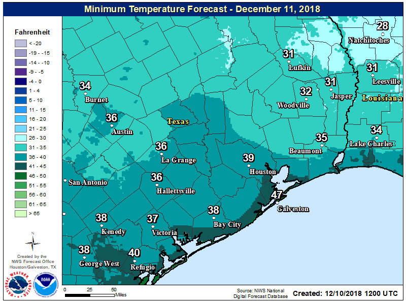
Houston to get wet this week, and weekend

Good morning, everyone. It will be a fairly quick post this morning, as Matt is traveling, and I’m in Florida for the Falcon Heavy launch, which may liftoff as early as 12:30pm CT today. (If you’re interested check out these photos of me and Elon Musk near the launch pad on Monday).

Tuesday through Wednesday morning

A warm front has essentially stalled along the coast, and this is creating foggy conditions across much of the area, which may linger into the mid-morning hours. “Clearing” skies is a relative term, as skies will remain cloudy throughout the day. As that warm front lifts back north, it will generate some showers and probably some thunderstorms later this afternoon across the area, with the greatest potential for severe weather to the north-northeast of Houston. I expect most areas will see about one-half inch of rain today, give or take, as temperatures top out at about 70 degrees.

It will be a wet week for southeast Texas, with much of Houston picking up 1-3 inches of rain from now through Monday. (Pivotal Weather)

Wednesday

A cold front will push through the region early on Wednesday, likely moving through the city by or before sunrise. This will not immediately scour the rain chances from Houston, however, and I expect most of the region to pick up another half inch of rain, or so, before the region finally begins to dry out later on Wednesday, or Wednesday night. Temperatures will be quite a bit colder behind the front, so look for readings only in the low 50s on Wednesday after the front moves through.

See full post

Mixed weather this weekend, but nothing too extreme ahead

The onshore flow has kept temperatures generally in the 50s across the Houston area this morning, and as a result we’re seeing the development of some fog across the area, although visibilities for the most part remain OK.

Thursday

We should see partly sunny skies later this morning, and this will allow high temperatures to climb into the mid- to upper 70s, with Houston possibly seeing its warmest day of the year. As moisture levels rise and a front drops out of the north, we may see a some scattered, light rain showers this afternoon, evening, and during the overnight hours. However anything that forms should not be threatening. The front itself could reach the northern part of the metro area by or before sunset today, and move through the region during the overnight hours.

Dewpoint temperatures for 6pm Thursday evening show much drier air behind the front, and the coast still remaining pretty humid. (Weather Bell)

Friday

Any rain should end after the front moves through, and we’ll be left with a chilly day Friday as northerly winds blow in, and highs struggle to climb above the mid-50s. Mostly cloudy skies will add to the winter-like ambiance.

See full post

Weekend forecast coming into better focus for Houston

Clear skies have allowed temperatures to cool down this morning, and more importantly they’ve afforded most of the region a good view of the total lunar eclipse. The Earth passed between the Sun and Moon just as the Moon set, and Sun rose over southeast Texas on Wednesday morning.

Wednesday

Southerly winds have returned to Houston, and this will allow temperatures to climb today to about 70 degrees under partly to mostly sunny skies. All in all, it should be a fairly pleasant day for the region, with temperatures tonight 10 to 15 degrees warmer than Tuesday night.

Thursday

Thursday will be even warmer, with highs in the mid-70s as southerly winds draw in warmth to the region. Some scattered, light showers are possible during the afternoon, evening, and overnight hours as a cool front approaches the area, and moves through. It should be off the coast before sunrise on Friday.

Thursday will be one of the warmest days of the winter in Houston. (Pivotal Weather)

Friday

A much cooler day, with mostly cloudy skies and highs generally in the upper 50s. Winds will be out of the north, but I don’t think they’ll be too gusty like they are after some cold fronts we get. Lows Friday night should fall into the 40s for most of the region.

See full post

Mostly clear weather for Wednesday’s total lunar eclipse

Houston is seeing temperatures this morning that range from the mid-30s inland to the upper 40s along the coast. This will probably be the region’s coldest night for about a week or so, and at this point another freeze seems unlikely for the next 10 days.

Tuesday

The region will see quintessential winter weather, with highs of around 60 degrees under full sunshine. Lows Tuesday night and Wednesday morning will probably be about 5 degrees warmer than Tuesday morning and, importantly, skies should be mostly clear.

Lunar eclipse

Clear skies are important because of the opportunity to see a total lunar eclipse shortly before the Moon sets. For Houston, the totality begins at 6:51 am but the partial eclipse begins about an hour before that, so plan to get up a little early tomorrow to see a neat celestial sight. You’ll want a jacket.

Texas will see a total lunar eclipse on Wednesday morning as the Sun rises, and Moon sets. (Fred Espenak)

Wednesday

Southerly winds will return sometime on Tuesday, and that will allow for the return of scattered clouds on Wednesday, and nudge temperatures into the upper 60s. We should also see a much more mild night, with lows only in the 50s across the area.

See full post