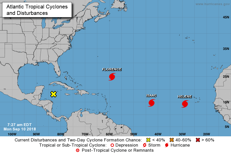
Man, I hate this time of year. Invariably, the tropics reach their crescendo, and this year is no different. In fact, this is only the 11th time on record that three hurricanes have been active in the Atlantic simultaneously, Florence, Helene, and Isaac. This week, Hurricane Florence will rightly suck up a lot of the national oxygen—Matt did a commendable job of summarizing the risks to the Carolinas and beyond, and they are tremendous in terms of flooding, wind, and surge—but we have some homegrown threats to consider as well.
Tropics as of 7am CT on Monday. (National Hurricane Center)
For this post we are going to focus on the near-term threat of heavy rainfall on Monday and Tuesday, and then the late-week threat from a nascent tropical system. Did I mention that I hate this time of year?
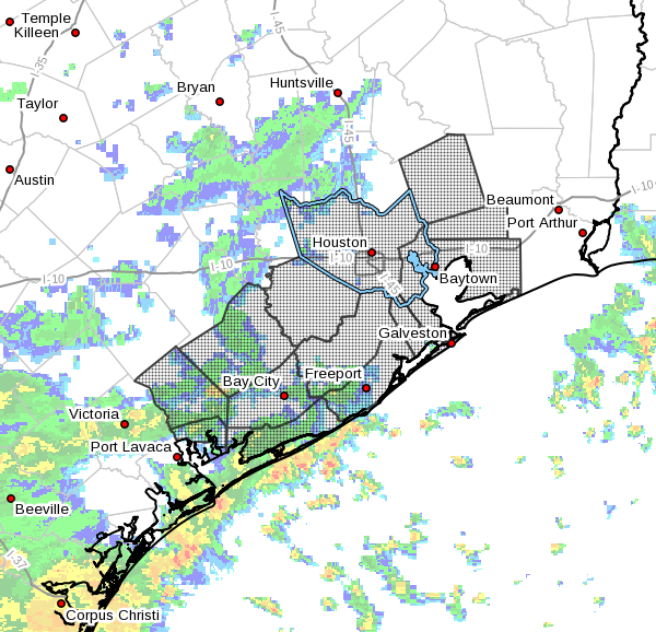
Monday and Tuesday flood watch
The National Weather Service has issued a Flash Flood Watch for the coastal and inland tier of counties for 1pm Monday through Tuesday morning, and they admit they may have to extend it. Basically, we have a lot of low pressure hanging around and a super-moist atmosphere. I think at best we can hope for scattered, heavy rain showers; and at worst we probably will see some spots of 3 to 6 inches over the next two days. Most likely the hardest hit areas will be along the coast, and if we’re lucky the heaviest rains will fall offshore.
Area of flash flood warning in effect through Tuesday morning. (National Weather Service)
Both Monday, Monday night, and Tuesday will probably be similar in this regard. We’ll just have to watch radar trends and if you have to drive for more than a short errand, you should probably check road conditions at your destination. This shouldn’t be anything more than street flooding, but we can’t guarantee that.
Houston will have another day of somewhat drier weather before a wetter pattern returns to the region through Monday. Yes, another soggy weekend. Sorry about that. Also, while we’re on the subject of bad news, if you’re wondering when fall’s first front might arrive, I’m afraid there just aren’t any really strong signals for that right now. I would not anticipate it coming before around Sept. 20, if then.
Thursday
The region should see some partly sunny skies today, so enjoy the sunshine while you can. Some isolated to scattered showers will be possible, but for the most part it should be a dry day. More sunshine will mean higher temperatures, so we can probably expect low 90s for most of Houston, with a smattering of mid-90s possible.
Friday, Saturday, Sunday, and Monday
Unfortunately, the pattern for this weekend looks wet, with low pressure in place overhead and a plenty moist atmosphere. Effectively this means that most areas of Houston (50 to 70 percent) will see rain on most days from Friday through Monday. Although the forecast models aren’t forecasting any rain bombs at this time that might lead to some street flooding, with this kind of atmosphere during the summer months we can’t rule out some heavier showers that temporarily clog streets.
Temperatures, as usual, will depend upon the extent of cloud cover and rainfall. Look for a range from the mid-80s to lower-90s. Humidity, of course, is guaranteed.
September has been a wet mess for most of Houston, but the one upside has been temperatures. At a time when we typically see highs in the mid-90s, the last three days have generally produced highs in the 80s. And if you like this wet, slightly cooler than normal pattern have we got a deal for you. Because this rain-lovers-delight pattern should continue for quite awhile.
Wednesday and Thursday
These days should be drier than the recent weather in Houston, but only in the sense that showers and thunderstorms should be more of a scattered nature rather than widespread. Even so, we expect 30 to 50 percent of the region to see some form of rain the next two days. Highs will depend upon shower activity, and likely will range from the upper 80s to the lower 90s. Sunshine will be scarce, but we can probably reasonably hope for a few breaks in the clouds.
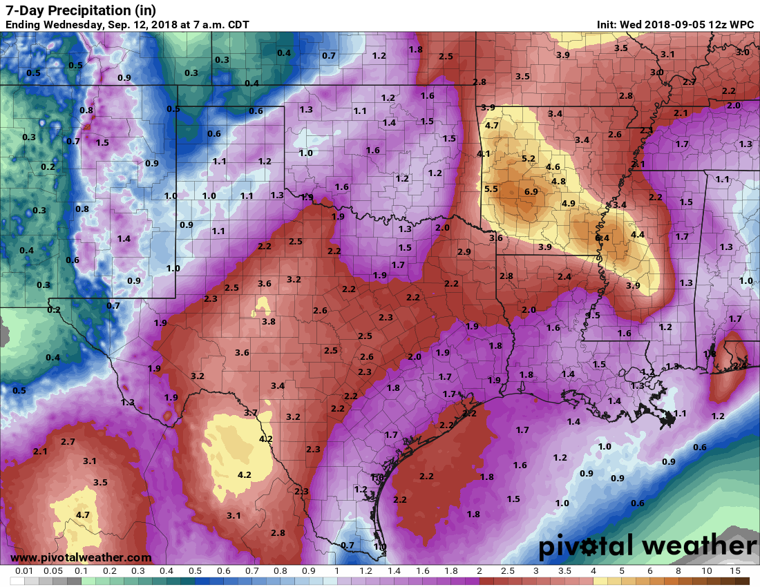
The NOAA rain accumulation forecast for now through next Tuesday looks healthy, but not extreme. (Pivotal Weather)
Friday, Saturday, and Sunday
As whatever is left of Tropical Storm Gordon moves well north of Houston, toward Oklahoma, it will leave lower pressures in its wake for our region. This will lead to, again, a healthy chance of rain showers through the weekend, probably around 60 percent each day, give or take. This should keep highs in the 80s or low 90s, and unfortunately we’re going to hold onto those mostly cloudy skies. If you’re planning outdoor activities, uhhh, have a back-up plan.
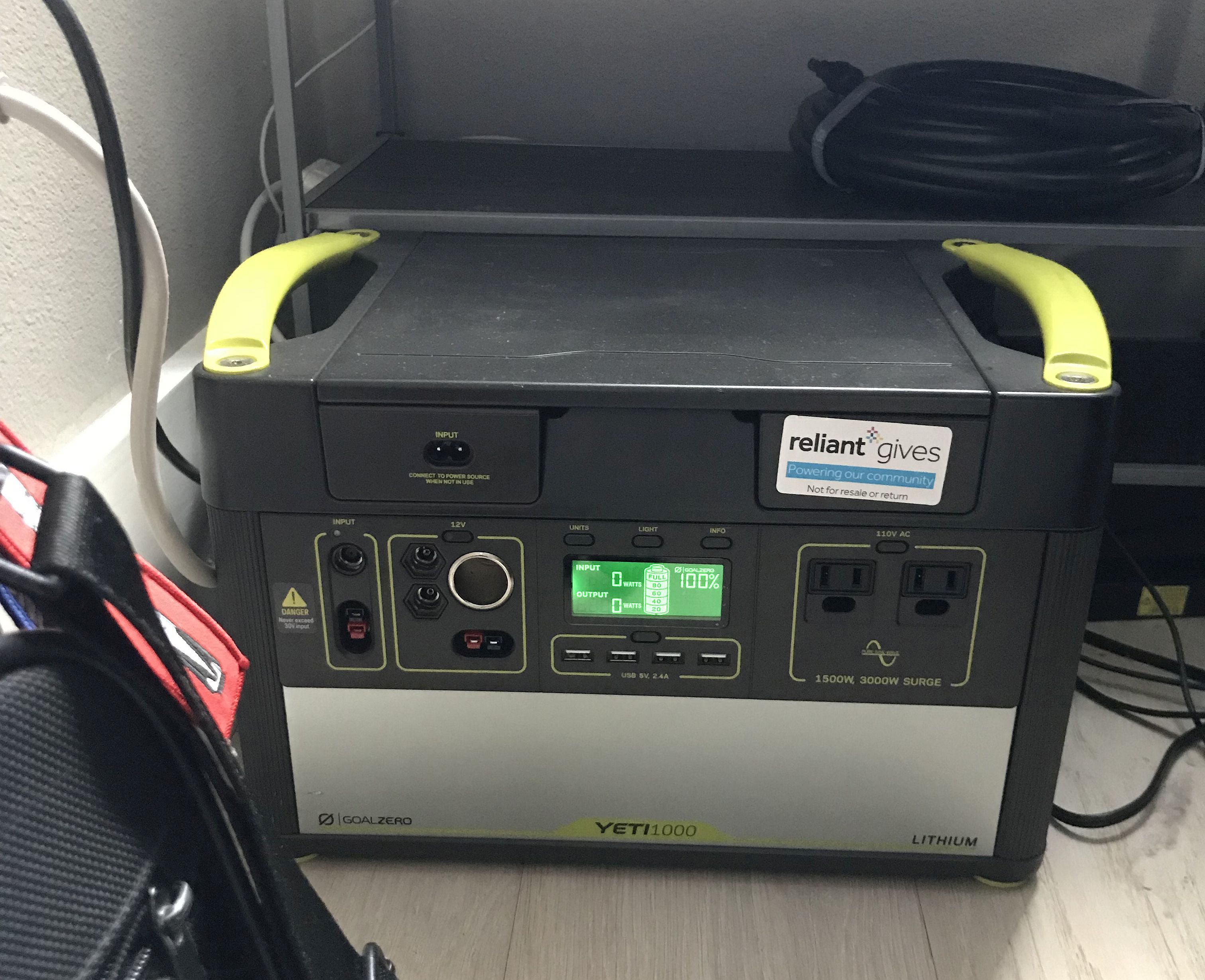
During Hurricane Harvey I hunkered down with two fully charged laptops, a mobile phone, and several power banks to keep the phone charged. This was perhaps not the most professional setup, but I was living in a third-floor apartment at the time (we were building a home), and frankly I did not think sustained power loss would be a major concern. Fortunately, the power never blinked off during Harvey, and I was able to remain connected at all times to the Internet and this site. The power staying on, however, is the exception rather than the norm during a hurricane. So I knew I needed a better solution for future storms. Fortunately our sponsor, Reliant, had a solution and provided me with a portable power station—the Yeti 1000—from their sister company, Goal Zero.
The Goal Zero Yeti 1000.
I am not a particularly handy person, so technology like this intimidates me a little bit. One box arrived with the power unit, and the other a solar panel about one meter in length and diameter. What was I supposed to do with this?
It turns out that the Yeti is ridiculously easy to use. The first step was to plug in the power unit—about the size of a 12-pack of beer, but twice as heavy—into an electrical outlet. Within about six hours the battery was fully charged. This was a month ago. I checked the unit just now (which is tucked behind a chair in my office), and it remains at 100 percent. I understand the battery will maintain a full charge for nearly a year so I can simply put the unit away and forget about it until the power goes out.
And what happens if the power goes out? This unit could literally power two laptops and several mobile devices for days, and days, and days. It could also power a medium-sized refrigerator for about a day, before the battery runs down. In that case, one could use the solar panel (which is also plug and play) to recharge the power unit during the daytime. Of course, during a hurricane itself, you’re not going to get much sunshine. But after the storm, certainly, this could probably keep a medium-sized refrigerator going intermittently for several days with the use of the solar panel. I can’t speak to this for every refrigerator or larger appliance, but if you have questions they can be answered by [email protected]. Additionally, the unit itself has a digital display that regularly updates the amount of power being used, and the battery time remaining. It is all incredibly intuitive.
My Yeti, still fully charged after sitting dormant for a month.
This unit is not meant to replace the full-home functionality of a large outdoor generator. That is not its purpose (nor its cost). Rather, it is meant to provide some peace of mind during a storm, to keep a few lights on, a fan running, power a television, or to keep your electronics charged. Moreover, it does so in a compact package, with absolutely no noise or mess. And when it’s not storming? This is an amazing unit to bring tailgating, camping, to the beach, or anywhere else you don’t want to entirely leave the comforts of civilization and connectivity behind.
But mostly, for me, it brings piece of mind knowing that during the next storm I’ll be able to remain plugged into Space City Weather, and provide timely information and weather updates to all.