It’s kind of crazy to think that our last full tropical update was two weeks ago, and we noted how things were about to ramp up. For many folks in Louisiana, the world is a much different place today than it was then. For Houston, I think we had a moment there. You exhale, but then you realize that nothing has really changed, and all it takes is one more storm to bring us right back to where we were sitting in the days before Laura. So will that happen? Probably not, but let’s walk through things.
Tropical outlook in a sentence
We expect several systems to develop over the next week or two across the basin, but right now only one of them is worth seriously watching and even it will be racing against the potential cold front next week.
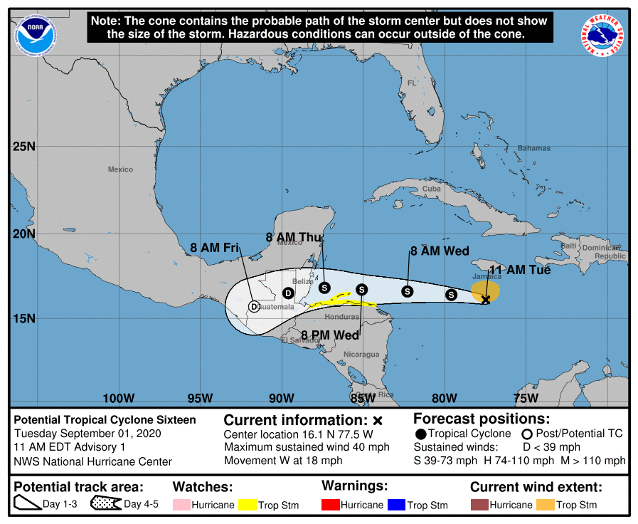
Potential Tropical Cyclone 16
The system that we referred to as Invest 99L yesterday has been classified as Potential Tropical Cyclone 16 (PTC 16) in the Caribbean this morning, meaning it is expected to become a depression or named entity soon. It looks fairly healthy on satellite, and it will likely develop over the next couple days.
Potential Tropical Cyclone 16 is not a threat to the Gulf of Mexico, but it will deliver heavy rain to parts of Central America. (NOAA)
Fortunately, thanks to our oppressive heat in Texas, with sprawling high pressure over the Gulf of Mexico, this will keep PTC 16 well to our south. No need to worry about this coming to the Gulf. So what is coming after this system?
Good afternoon. Hurricane Laura has rolled on into Arkansas this afternoon and weakened to a tropical storm. However it has left a trail of destruction in its wake. This post will be very image heavy, with a number of pictures of damage that caught my eye through the day in Louisiana that I’d like to share. A quick forecast update will follow.
Let’s start with the Doppler Radar. The Lake Charles Doppler, sited at the airport south of the city (which reported over a 130 mph wind gust) saw its radome blown to pieces.
The scenes in Lake Charles really do look like a giant tornado just ripped through the city. The one large skyscraper in downtown Lake Charles, Capital One Tower sustained severe damage. This building also took a severe hit during Hurricane Rita in 2005.
First light allows us to see the scope of the damage in Lake Charles this morning. Needless to say, its not good. pic.twitter.com/cJVI3y9Y3n
The KPLC-TV tower crumpled and fell onto or adjacent to parts of the TV station building. This one had apparently survived Audrey, Rita, and Ike, but finally succumbed to Laura.
There had been some speculation that the I-10 bridge in Lake Charles (which, if you’ve ever driven, you just know, trust me) might sustain difficulties under a record storm surge. Well, it’s still standing, although it has a casino boat stuck underneath today.
Lake Charles did not receive the expected record surge thanks to a landfall basically right at Calcasieu Pass (had it hit land even just five miles west, the story today would be much different), but they did receive a pretty serious surge in that area.
That surge was notable, however, it can be seen from space.
The effects of #Laura’s storm surge in SW Louisiana is visible on satellite. The top image is Tuesday and the bottom image is now. Note the temporary regression of the coastline. This water will gradually retreat into the Gulf, but this shows how big of an impact surge can have. pic.twitter.com/OVShOy2KcD
You can see especially east of Calcasieu Lake (the 2nd larger inland lake from the left) how much land mass ended up underwater. There is a reason that part of coastal Louisiana is not heavily populated.
Back in the Lake Charles area, in addition to everything, a large fire broke out (not at oil refineries as the tweet says) at the KIK Custom Products Biolab in Westlake, just off to the west of the city. The fire prompted a shelter in place order for the area.
Moving even farther south to the coast, Holly Beach is a mess, though it does not look as bad as feared. They came in just west of the eye and avoided the absolute worst of Laura.
However, for a sobering view, here’s helicopter footage from Cameron, where Laura came ashore. Note the occasional slabs where structures used to stand.
Anyway, the purpose of showing you these photos and videos, aside from informational value is to understand that Lake Charles is about 30 miles from the coastline. If a northwest moving storm of Laura’s size and intensity came ashore at, say, San Luis Pass (an Alicia track but with a larger & stronger storm), the result would be a very large chunk of the Houston area resembling what we see in Lake Charles. It would be devastating. And if you think it couldn’t happen here, think again. It could easily happen, and I’m fairly confident we are not even remotely prepared for what that would look like. Instead of viewing Laura as another Houston near-miss, it would be wise for all of us to view this as an informational session on what could happen here and think about what we will do in the days before it does.
Houston weather
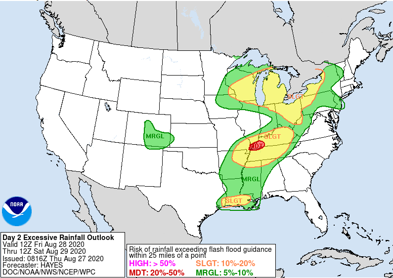
I just want to make a quick note about the weather here in Houston tomorrow. We’ve seen signs on the models that sort of a trailing band of moisture feeding Laura’s remnants will set up over southeast Texas and Louisiana. At this point, we’d just expect scattered thunderstorms across the area on Friday. However, it’s feasible that a slower moving band of heavier rain sets up somewhere near or east of Houston tomorrow and dumps some heavy rainfall.
The Weather Prediction Center has the eastern part of the Houston metro area in a borderline marginal/slight risk of excessive rainfall tomorrow, meaning heavy rain is possible. (NOAA)
The Weather Prediction Center of NOAA has the eastern fringe of the metro area not far from a “slight” risk (Level 2/4) of excessive rainfall Friday. While this is more likely to be directed into Louisiana, it’s entirely possible this sets up closer to Houston. So, we just want you to be aware of the risk of some locally heavy rainfall tomorrow. Thankfully, we didn’t see much of anything during Laura’s passage, so we have a good amount of room to absorb any rains.
As of right now, Eric and I are intending to take tomorrow off as a necessary recovery day. However, if it appears the rain risk will become more significant, we’ll chime in with an update. In the meantime, have yourselves a good evening.
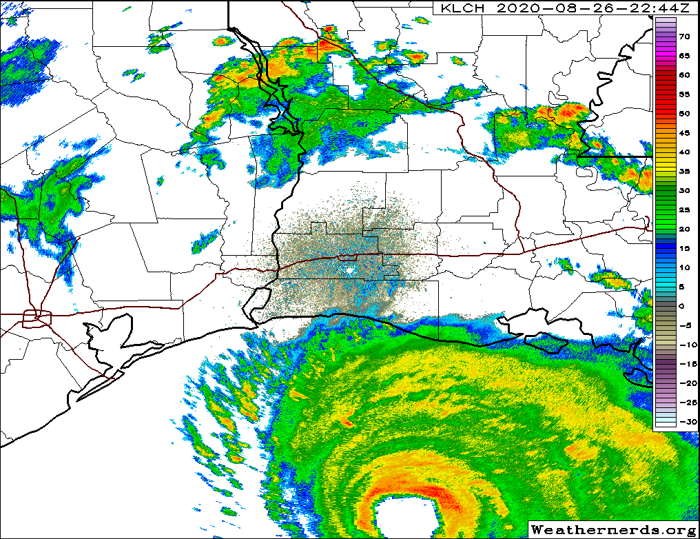
POSTED AT 8:20 PM CT WEDNESDAY: Hurricane Laura has made its turn to the north in earnest late this afternoon and evening, and is likely heading for landfall on the Louisiana coast, possibly near Calcasieu Pass, south of Lake Charles.
Hurricane Laura is approaching the Louisiana coast this evening, about 95 miles south of Lake Charles and southeast of Port Arthur. (Weathernerds.org)
Wherever it makes landfall doesn’t mean much now short of who sees the absolute worst of the strongest hurricane ever recorded in this part of the Gulf of Mexico.
NHC made it official… #Laura is the first Category 4+ hurricane on the record for the current location. Barring a complete collapse… #Laura will also be the most powerful hurricane to ever strike the Sabine Pass region. #LAwx#TXwxpic.twitter.com/ChtfB59tqU
It’s going to be a hellish night for folks in extreme southeast Texas and southwest Louisiana. Nothing seems to be slowing Laura down, which is par for the course for a storm that somehow dodged nearly every conceivable hurdle imaginable in the Caribbean and brought us to this point. While Laura is still expected to come ashore “past peak,” it will still likely be the worst hurricane on record for this particular portion of the Louisiana coast. Conditions will now begin to rapidly deteriorate in far southeast Texas and Louisiana, progressing up to landfall around midnight. There’s really not much else to say at this point except godspeed to folks in the path.
Houston area
See our earlier afternoon post for a breakdown of what we expect in the Houston area and elsewhere. Most of these impacts are unchanged and may even be forecast too high.
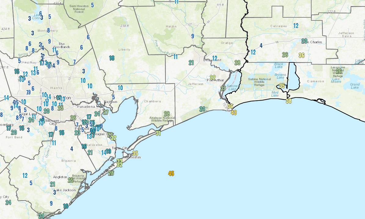
Wind gusts as of 8 PM are not that bad in Houston. We may only see slightly stronger gusts overnight. (NOAA)
The highest wind gust as of 8 PM in the Houston area is about 25 mph at Hobby Airport. Galveston is gusting to around 30-35 mph. We do expect these gusts will increase a bit overnight, but with the storm now on a mostly north-northwest heading, we’ll see how far west the 30 to 40 mph gusts can make it.
There is surge still happening though, and the Bluewater Highway in Brazoria County is now closed from Surfside to San Luis Pass because of water and debris.
Surge levels look to be about 3 to 4 feet so far at San Luis Pass up through Galveston.
There are not many showers around Houston at the moment, and we will likely have a quiet evening. Rain could commence at times overnight, and it will likely fall east of I-45 and along the coast as Laura lifts inland. Our best chance of heavier rain in Houston may come in Laura’s “tail” wake on Friday. We’ll update you more on that tomorrow.
Eric will have our next post no later than 11 PM CT tonight.
POSTED AT 2 PM CT WEDNESDAY: Good afternoon. Hurricane Laura has continued strengthening in the Gulf of Mexico all day so far, showing no signs of slowing. It is now up to category 4 intensity, with maximum sustained winds of 140 mph.
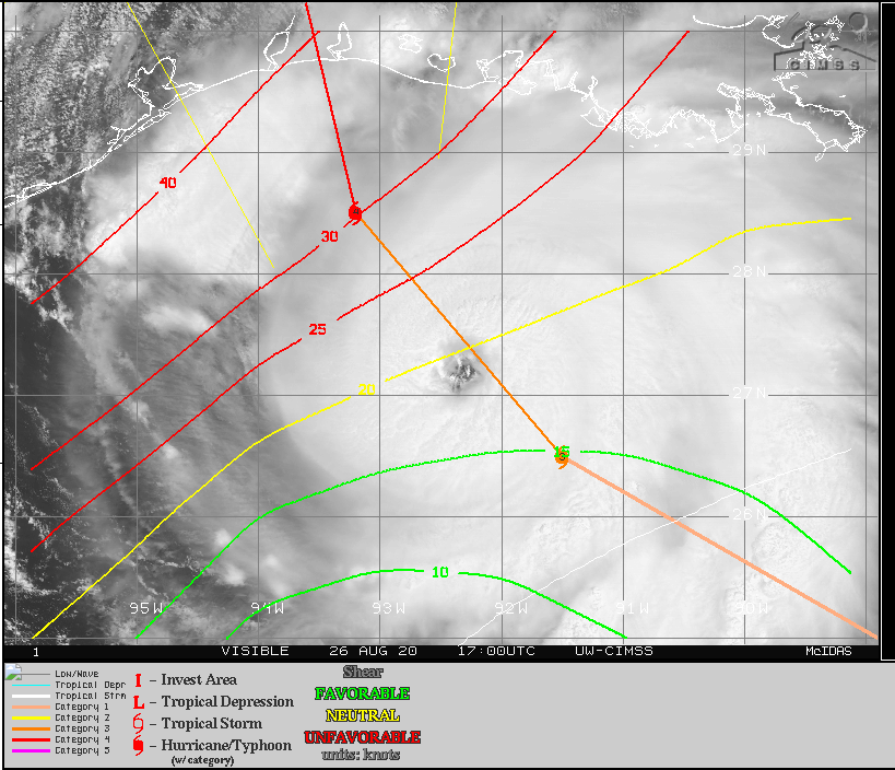
Could Laura achieve category 5 status before landfall? It’s possible, as there are no signs of strengthening slowing down as of this writing (pressures keep falling). Laura is expected to come ashore below its peak intensity. It may feel the effects of some wind shear, shown in red on this map below.
Wind shear is expected to increase as Laura approaches the Gulf Coast, which may aid in slowing down the intensity a bit at landfall. (University of Wisconsin CIMSS)
That shear is moving with Laura to the north, so it may not help as much as you’d otherwise hope. More likely, Laura could experience what is known as an “eyewall replacement cycle” before landfall; basically a way for the storm to reorganize itself. When that happens, a drop in intensity usually occurs, sometimes substantial. We hope this happens right before landfall, which would allow Laura to come in on the decline, rather than at maximum intensity. Unfortunately, this aspect of the forecast is difficult to predict and we are really only relying on hope at this point. It’s possible Laura could just continue strengthening right up to landfall, similar to what Hurricane Michael did 2 years ago near Panama City, FL, though as a colleague of mine pointed out in a conversation earlier, the coastal topography of the Gulf here is much more shallow than off Florida. Shallow water can be more easily churned up and help to reduce the fuel available for hurricanes to feed off of. Whatever it is at landfall doesn’t much matter at this point, as it will still likely be bad.
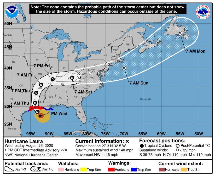
Laura is moving northwest at 16 mph, which is blazing fast for this part of the Gulf. For folks in Houston, it’s important to know that Laura is doing what is expected, and “the turn” is underway. It’s not “if” or “when.” It “is” happening, and thankfully in the world of 21st century meteorology we can say that with authority. We will not be hit too hard here by this storm. Laura is expected to make landfall on the Cameron Parish side of the Texas/Louisiana border as a category 4 hurricane tonight perhaps around or just before midnight.
Laura will make landfall near or east of the Texas/Louisiana border tonight, likely as a category 4 hurricane. (NOAA)
Let’s walk you through the expected wind and surge impacts at this time.
Houston area: West of I-45 (The Woodlands, Katy, Cypress, Sugar Land, etc.)
Periods of showers and thunderstorms possible to likely tonight. Impacts peak between 9 PM and 3 AM with winds of 15 to 25 mph and gusts as high as 30 mph or so.
Houston area: East of I-45, north of I-10 (Kingwood, Humble, Crosby, etc.) Impacts peak between 9 PM and 4 AM with winds of 15 to 25 mph. Gusts will peak around 35 mph or so.
Areas around or just inland from Galveston & Trinity Bays (Bay Area communities, Texas City, League City, Baytown, etc.) Impacts peak between 8 PM and 4 AM with sustained winds of 25 to 35 mph and gusts of 40 to 50 mph, highest south, lowest north. Surge of 1 to 3 feet, though northerly/northwesterly winds may push water to the south toward Galveston
Galveston & Bolivar Impacts peak between 8 PM and 4 AM with sustained winds of 30 to 40 mph and gusts of 50 to 60 mph, or a bit higher possible. Storm surge on Galveston Island is expected to be on the order of 1 to 4 feet, with the bay side experiencing surge as well. Storm surge on the Bolivar Peninsula may be as high as 4 to 5 feet.
Beaumont-Port Arthur-Orange area Impacts peak between Midnight and 5 AM with sustained winds of 75 to 90 mph and gusts of 95 to 110 mph. Surge of 10 to 15 feet into Sabine Lake.
Lake Charles area Impacts peak between midnight and 6 AM with sustained winds of 75 to 100 mph and gusts of 95 to 120 mph. Storm surge of 15 to 20 feet into Calcasieu Lake.
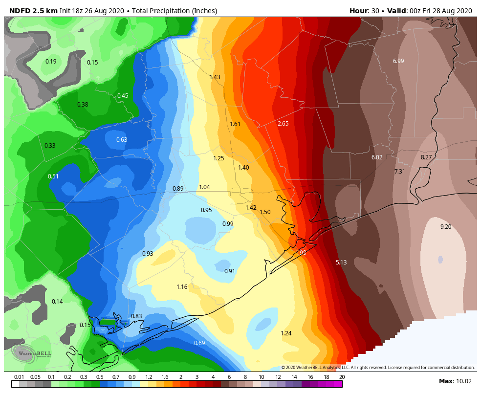
Rainfall Just to further put you at ease, the total rainfall through tomorrow in the Houston area is expected to be 1 to 2 inches total. Many places will likely see less than this. A few to the south and east may see a bit more.
Laura’s passage will not be a flooding event in Houston. (Weather Bell)
But in this case, flooding, other than some nuisance street flooding is not expected. On Friday, we may see a slightly better chance of some heavier rain as modeling has been in agreement on a better signal for storm chances from a trailing band feeding into Laura’s remnants over the Mississippi Valley then. Something we’ll check into more closely tomorrow.
So again, just to summarize, Laura is moving northwest and will turn more north-northwest this evening, likely making landfall on the Louisiana coast, well east of Houston, as a major hurricane. Eric will have our next post no later than 5:30 PM CT.