Good morning. We’re here to offer up a brief update on Hanna as the storm works its way into Mexico this morning.
Houston area
Things are quiet this morning in Houston. There are some showers south and west of us and another batch moving across the coast of western Louisiana. As some of this works into Texas, we should see showers and storms become scattered across the area.
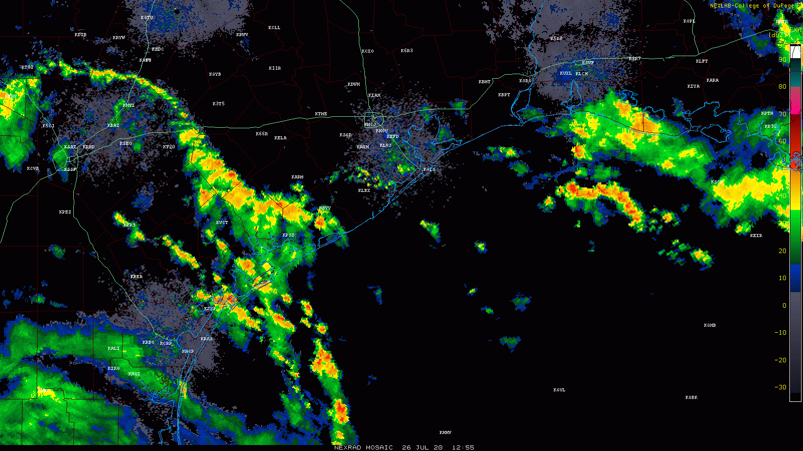
Showers and storms in Louisiana will likely work toward our area today, bringing at least scattered rains, some heavy, to the Houston area. (College of DuPage)
Some folks won’t see much, but others may see a couple inches of rain in an hour or two this afternoon. An isolated severe storm is also possible. More typical scattered showers and storms will continue to be possible tomorrow and Tuesday, as onshore flow continues.
Rio Grande Valley
Hanna has moved into Mexico this morning, but the storm’s rains continue in the Valley. Mission has probably been the hardest hit of any of the cities in that area, and a flash flood emergency is posted for that area through late morning, as upwards of 10″ of rain has fallen, with more coming.
⚠️ WIDESPREAD FLASH FLOODING ongoing in our city and it will be several more hours before the rain lightens up in the area. THIS IS A DANGEROUS SITUATION. DO NOT drive into standing water. 🌧 #TurnAroundDontDrownpic.twitter.com/NdzKfbpYoT
— City of Mission, TX (@CityOfMissionTX) July 26, 2020
The heaviest rain as this is being written is falling east of Mission and just west of Harlingen. Several more inches of rain is likely to fall today and tonight as Hanna dissipates inland in Mexico.
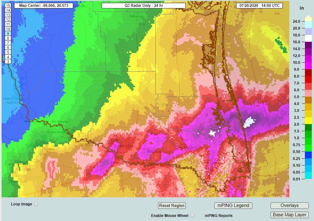
Totals are impressive, especially just north of the Valley.
Areas in purple on this map of estimated rainfall are likely to have seen 9 to 10 inches or more of rain so far. (NOAA NSSL)
You can just make Mission out as the western-most purple area on the map, with upwards of 9 to 10 inches of rain. Other hard hit areas include Weslaco and Harlingen. The area just northeast of there with maximum totals is estimated to have received close to 20 inches of rain.This is right on the Arroyo Colorado near Arroyo City on the Cameron/Willacy County line.
Conditions should improve in that area tomorrow with more scattered showers and storms, but flooding could worsen in spots still today before subsiding. We will have the latest on the rest of this upcoming week tomorrow morning.
Good morning everyone. Tropical Storm Hanna formed last night, and it wasted no time gradually getting itself organized. As this has been happening, Hanna’s forecast track has continued to shift south, taking most of the significant impacts expected from the storm out of the Houston area. A lack of significant impacts doesn’t mean we’ll have zero impacts, however, so we’ll break down what to expect here and farther south in Texas as well.
Now
As of 5:30 this morning, Hanna was over the Gulf, about 300 miles east-southeast of Corpus Christi. Hanna was moving slowly but steadily just north of due west, around 10 mph or so. Maximum sustained winds were estimated to be 40 mph, but a reconnaissance aircraft from NOAA is headed into the storm to see if that hasn’t increased somewhat. Based on Hanna’s satellite presentation, we can assume it probably has strengthened a bit.
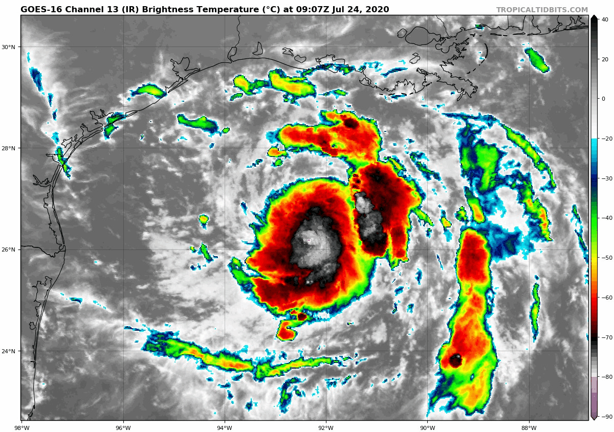
Tropical Storm Hanna on Friday morning had a lot of storms, though most of them were somewhat displaced to the south and east of the center as it tracks west toward South Texas. (Tropical Tidbits)
You can see a robust area of thunderstorms near the center of the storm. If you want to lodge a meteorological complaint about Hanna, it would be that the vast majority of thunderstorms are displaced to the south and east of the center of the storm. In other words, despite the pretty serious look on satellite, the storm does suffer a bit from a lack of symmetry that could indicate that while it’s strengthening, it may not be taking off like a rocket. It is likely still feeling a bit of wind shear, especially on its eastern fringe that is holding it back a little. Still, this is not an unhealthy storm and forecasts of strengthening up through landfall will likely come to pass.
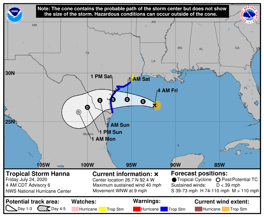
The current National Hurricane Center forecast tracks Hanna toward the coast, arriving tomorrow midday somewhere between about Corpus Christi and South Padre Island, likely close to Baffin Bay.
The official NHC forecast continues to keep Hanna well south of Houston, with the most significant impacts in South Texas, while our area sees mostly nuisance-type impacts. (NOAA)
This will direct the most significant tropical impacts south of Matagorda Bay. Hanna keeps moving west and then southwest into Mexico, where it should dissipate on Sunday night or Monday.
Quick overview of what to expect for the Houston area
Here’s a quick “user’s guide” for what to expect in the Greater Houston area.
Rain: Isolated storms Friday, scattered storms Saturday, more numerous storms Sunday and maybe Monday. Rain totals of 1 to 2 inches on average, with higher amounts possible anywhere, but especially the farther south you go, possibly in excess of 3 or 4 inches in Matagorda. Lesser amounts possible north.
Flooding: Some street flooding is possible with any downpours, as is always the case in our area. Significant, widespread street or bayou flooding is not expected.
Wind: You should not expect winds to get much past 15 to 20 mph in the Houston area. Tropical storm conditions should be confined to the coast, with gusts up to 30 to 35 mph in Galveston and perhaps a bit stronger toward Freeport and the Matagorda Bay region.
Tidal & marine impacts: We expect tides to run about 1 to 3 feet higher than normal for Galveston and maybe a tinge higher toward Matagorda Bay. Minor overwash or tidal flooding is possible. Rip currents will be strong, so please use extreme caution. Waves are expect to be about 4 to 6 feet, maybe higher farther south.
Severe weather: Brief spin ups are possible in thunderstorms, especially as you get close to the coast, where a waterspout or two could occur.
Details for the Houston area
For today, we would anticipate isolated to perhaps scattered showers and storms. Expect a general trend of storms near the coast this morning, spreading inland this afternoon. Some locally heavy downpours are possible, but today should not be much worse than a typical summer day.
As Hanna approaches the south Texas coast tomorrow, expect the potential for steadier, heavier rain south of Houston. This would include Galveston, but we would especially include far southern Brazoria, Matagorda, and Jackson Counties. Tropical Storm Warnings are hoisted from San Luis Pass southward, so those areas are the ones most likely to also see tropical storm conditions. Showers and storms to the north of there will be mostly scattered on Saturday. In other words, some of us will see some heavy downpours, others may not see much of anything. The chance of heavier rain is obviously higher the farther south you go in the area.
The Houston area’s best chance at more numerous showers and storms and heavier rain will probably come Saturday night and Sunday as a surge of moisture comes in off the Gulf and out of Louisiana. That may continue off and on into Monday as well. By Tuesday and Wednesday, we should slowly return to a more typical summer pattern, with hotter weather.
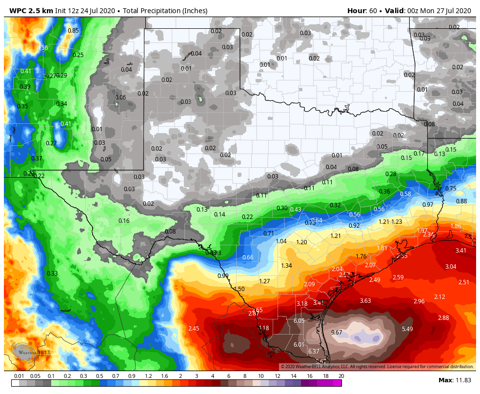
When all is said and done, we expect probably 1 to 2 inches of rain on average in the Houston area, with a skew toward higher amounts south of the city and lower amounts to the north.
The current forecast of total rainfall is about 1 to 2 inches on average for the Houston area. The big ticket rainfall totals from Hanna will likely be south of Corpus Christi and in the Rio Grande Valley (Weather Bell)
However, depending on exactly how storms set up on Sunday, we could see as much as 2 to 4 inches of rain in spots, with the highest likelihood of this being south of I-10 and on the south and east sides of US-59/I-69.
Today’s update will talk briefly about that Gulf disturbance coming to Texas this weekend, but more about what is behind that system as it appears the tropics are waking up, and they may not shut back down for a while.
Tropical outlook in a sentence
We expect a low-end system to form in the Gulf this week, another system will make an attempt to develop in the Atlantic, east of the Lesser Antilles, and with more waves emerging off Africa, more development will be possible heading into early August.
Gulf system
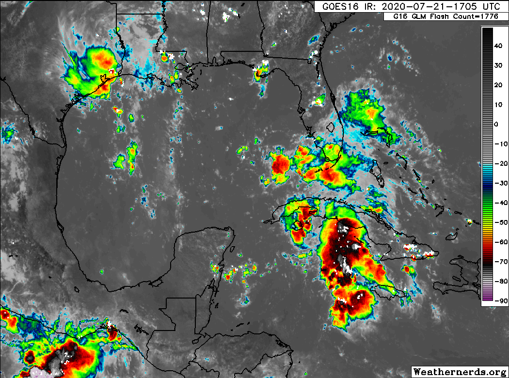
Eric has done a good job each morning discussing what we know and expect from the potential late week system in the Gulf. As of this afternoon, the system is a disorganized “blob” of thunderstorms over and around Cuba.
Disorganized storms near Cuba will have a window to develop as they move toward Texas Friday and Saturday. (Weathernerds.org)
However, as that moves into the Gulf, it will find decreasing wind shear and fairly warm water to work with. It seems there are two things that will hinder this system’s development into anything worse than a depression or moderate tropical storm: 1.) It will enter the Gulf disorganized. And 2.) It will move at a steady clip, so it’s going to run out of time over water fairly quickly to develop. So the ceiling is constrained by time. Still, a strengthening tropical storm in the Gulf on approach to land is nothing to sneeze at or write off completely, so we’ll monitor this closely. Of note, the morning model data so far is not any further bullish on this system’s development prospects, and the National Hurricane Center maintains a 40 percent chance of development over the coming days. Regardless, we will see some locally heavy rainfall associated with this, be it as a disturbance or organized depression or storm. Thankfully, it is expected to keep moving at a steady pace. We will continue to monitor it for you, and Eric will have the latest in the morning.
Invest 99L is fairly far south and still a good bit east of the Lesser Antilles, and it appears to be gradually organizing into a depression as of Tuesday afternoon. (Weathernerds.org)
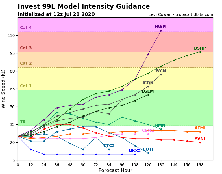
This system is very, very close to being a tropical depression already (as of this writing at 1 PM Tuesday). Invest 99L is going to be interesting. It’s rather far south and small, which will help shield it from a rather significant plume of Saharan dust off to its northeast. It is moving into an area of warm water temperatures and pretty low wind shear. Theoretically, this is a good candidate for development over the next 3 to 4 days as it approaches the islands. The various intensity models are very split on what happens here. I wouldn’t take the ultra high-end ones literally, but you can clearly see two camps: One that keeps the system middling over the next few days and another that says this thing will strengthen as it approaches the islands.
Intensity forecasts of Invest 99L in the open Atlantic vary from some holding it weak to others going off to the races with intensification. Much is still unknown here. (Tropical Tidbits)
Which camp is right? Great question, and one we don’t have an answer to at this time. There are good meteorological cases to be made for both a lower-end system, as well as one that perhaps organizes faster than anticipated.
The track & intensity of Invest #99L likely to be closely linked over the next 3-5 days.
Forecast low-level steering is faster & zonal but deeper-layer steering (850-200-hPa) is slower & more poleward. If 99L becomes a vertically deep vortex early (<48h), large impact on future. pic.twitter.com/TIFABN0CWz
Either way, interests in the eastern Caribbean should be monitoring the progress of Invest 99L closely. For us in Texas? It would be unlikely that this would survive the trip here. In fact, no storm within 150 nautical miles of where Invest 99L was centered this morning has ever made it to Texas, with the exception of Hurricane Allen in the Rio Grande Valley in 1980. So, if you’re playing odds, you’ll take those odds. We’ll continue to watch it however.
Of note, the next two names, which both could be utilized this week are Gonzalo and Hanna. The earliest “G” storm on record was Gert on July 24, 2005. The earliest “H” storm was 2005’s iteration of Harvey on August 3rd. Both records could fall.
It feels like it has been eons, but the last time it rained in the Houston area with any meaning was back on July 7th, or only about 10 days ago. Today will be our best chance since then at seeing some showers. Fortunately, we don’t foresee rain chances truly dropping to zero again anytime soon, but they will wax and wane as some features shuffle around the Gulf Coast. Let’s take a look.
Today
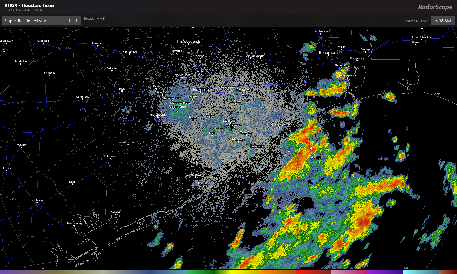
We have a weak disturbance coming at us today from Louisiana, and that will provide the impetus for scattered showers and thunderstorms, especially south and east of Houston. Radar is already lighting up this morning off the coast.
Showers and thunderstorms are numerous over the Gulf early this morning, and those will work toward coastal areas over the next few hours. (RadarScope)
Look for these offshore showers and storms to move onshore through mid-morning. Numerous showers and storms are likely south and east of Houston this morning. They will gradually advance farther inland this afternoon, but we think they’ll probably stay primarily focused south of I-10. If we’re talking about inland rainfall chances today, Sugar Land or Wharton probably have a better chance at seeing some than The Woodlands or Hempstead. Whatever the case, some of the rain is bound to be locally heavy wherever it falls, and a few locations could easily see 2 or 3 inches, while others will see absolutely nothing today.
That disturbance shifts away from our area later today and tonight, leaving us just warm and humid for tonight. Depending on the coverage of clouds and storms today, we could see highs only top off in the low-90s briefly. Some coastal areas may not get much past the mid-80s. Houston again hit 100° yesterday, so it certainly may feel a little better today.
Weekend
It does not appear that we will have another disturbance this weekend like we have moving through today. This means we should probably expect fairly standard summer fare for southeast Texas. Look for highs in the mid-90s, lows in the upper 70s to near 80, and a standard 20-ish percent chance of a passing shower or storm with each day’s sea breeze off the Gulf. In general, you’ll be lucky if you see rain this weekend, but there will be showers around on both days.
Monday and Tuesday
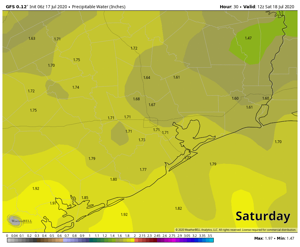
It would seem another weak disturbance may pass through on Monday, coinciding with an increase in Gulf moisture, which could bump our rain chances up a notch or two relative to the weekend. We’ve thrown precipitable water (how much moisture is available in the atmosphere) on the map below, and you can see that by late Sunday and especially Monday, we see an influx of Gulf moisture, with PWATs over 2 inches again.
Precipitable water (PWAT, or how much moisture is available in the atmosphere) will increase Monday, leading to better rain chances. (Weather Bell)
It still doesn’t appear that everyone will see a dousing here, but coverage of rain will be noticeably greater on Monday than it will be Saturday or Sunday. Tuesday should similarly see scattered showers or storms as well. Daytime highs will come off a couple degrees, so mainly lower 90s, maybe a few upper-80s in spots, with lows generally in the 70s, except perhaps at the coast.
Rest of next week
We will probably see a continued pattern of typical summer: Hot, humid, sunny for the most part, and days with one or two showers punctuated by a day or two of higher rain chances as some easterly waves move in off the Gulf. Friday may be one of the more active days as it stands right now. Settle in for a more standard Houston summer.