Friday night heavy rain on the way

Good morning. Let’s get right into the forecast here, as a significant winter rainstorm begins to bear down on Southeast Texas.

First off, Flash Flood Watches will go into effect for the entire region today and tonight.

The National Weather Service will hoist a Flash Flood Watch across the entire region at Noon today. (NWS Houston)

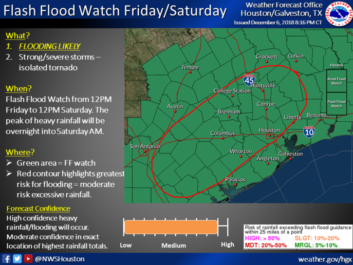
This means conditions will be favorable for flash flooding, street flooding, and some substantial rises in area creeks, rivers, and bayous. If you’ll be out and about tonight, you will want to have a way to receive updated weather information. Space City Weather will be updated through the night as well, but make sure you have a couple sources of the latest information and a way to see radar.

Also, something that’s occasionally underappreciated: If possible, please make sure your neighborhood storm drains are free of leaves and debris. We are “past peak” fall foliage in Houston now, and many leaves have found their way to storm drains and gutters.

Clearing these areas allows water to drain more effectively and will often mitigate some street flooding issues.

This morning

Radar this morning is quiet in Houston, but scattered showers have developed northwest of the city.

Radar as of just before 6 AM Friday shows some isolated to scattered storms and showers northwest of the Houston Metro. This will gradually slump south and east this morning. (RadarScope)

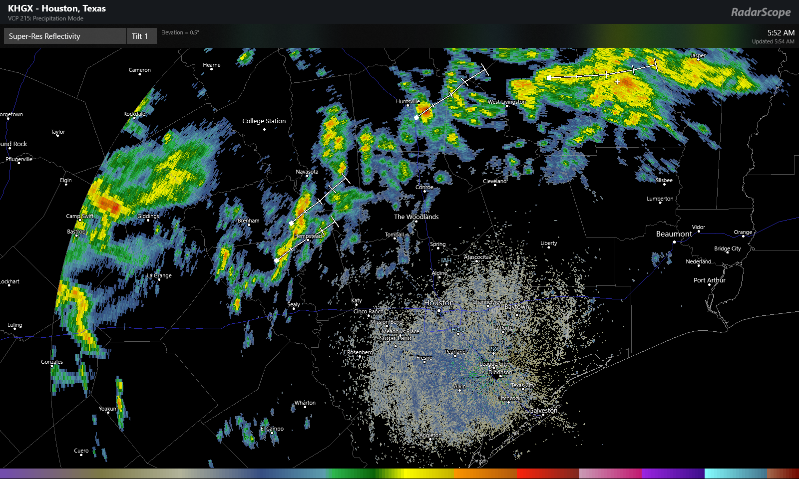
Expect scattered showers and the possibility of some thunder to continue through the morning hours north and west of Houston. This area should advance closer to Houston as well, bringing some rain chance to the city by late morning.

This afternoon

Expect showers and thunderstorms to become more numerous and widespread as we go through the afternoon, especially along and northwest of US-59. We will want to watch this to see if rain can advance farther southeast than expected, as this could push the steadier rains more into the central part of the Houston metro, rather than it being skewed northwest. Regardless, I don’t anticipate that we’re going to see a lot of flooding issues around the region through afternoon. That risk ramps up tonight (read more below).

But still, I would expect that we could see on the order of a half inch to two inches of rain on average during the daytime today from the city of Houston to the north and west, with lesser amounts south and east. However, we will need to watch southern and eastern areas later this afternoon for some isolated potentially strong to severe storms.

This evening

Steady rain could taper to scattered showers in spots, but in general, expect occasional showers, downpours, and thunderstorms through midnight, with the greatest concentration from the city of Houston to the northwest.

The HRRR model radar forecast for 9 PM tonight shows scattered to numerous downpours and thunderstorms across the area, especially along and north/west of US-59. Use caution if out and about tonight. (Weather Bell)

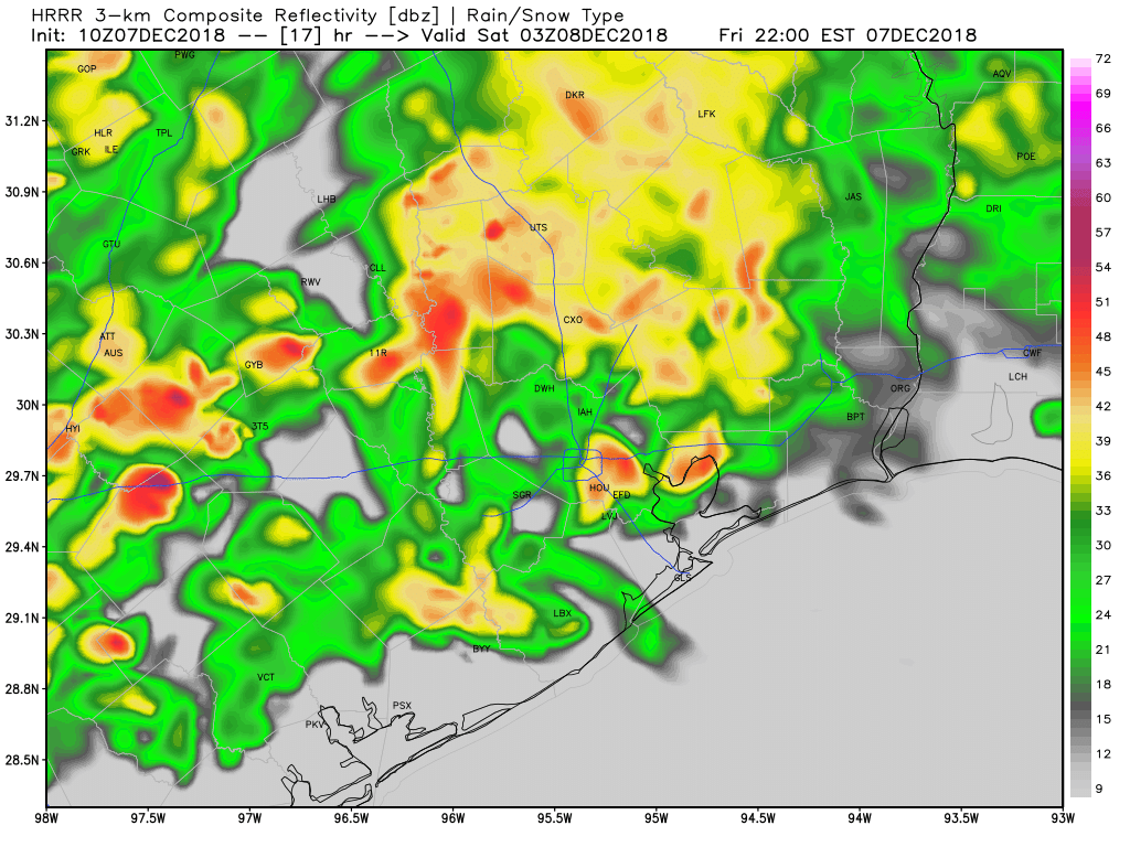
The image above is a forecast radar for 9 PM this evening. You get a sense of the patchy nature of things. Not everyone will be in downpours constantly, but some areas will get hit more often than others. If you get into a lull in the rain, just be advised that the event isn’t over and heavier rain will be incoming overnight from the west.

Overnight

This will be the main event. A strong, slow moving line of thunderstorms will plow across the entire region around or after midnight. This band of storms will be capable of producing 1-3″ of additional rain, or more, in short order as it moves west to east across the area. After today’s rains, grounds will be saturated, and runoff will be quicker than usual. This will be the band of rain most capable of producing widespread street flooding and leading to rises on bayous in the area. The areas most vulnerable to flooding will be those that see the most rain during the day today and in the early evening. Our assumption is that we’ll see this occur along and northwest of US-59. But we will obviously know more this afternoon as this event begins to setup.

Rain totals of 2-5″ on average are expected across the region between today and tonight. There is a chance areas southeast of Houston will see less rain, and a chance that a few places from Houston north and west could see as much as 5-10″ of rainfall. (NWS Houston)

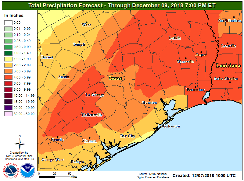
Once all is said and done, we expect two to five inches of rainfall across the area, with a few locations perhaps seeing as much as five to ten inches of rain. That will not be the case in most of the area, but there will be dollops of some of those bigger ticket totals in parts of the region. As noted, where those occur will determine who exactly is at highest risk of flooding. Obviously, use extreme caution if you’ll be travelling tonight and never drive through flooded roadways, especially at night, when it’s extremely difficult to judge how deep that water is that’s covering the road. Eric will have an update on how things are progressing later today.

See full post

Starting the week on a chilly note

After a mostly pleasant holiday weekend, a cold front came plowing through on Sunday and has brought us back to early winter as we start a new week. The good news is that it won’t be too cold for too long, nor will we have a lot of significant weather to discuss this week. Let’s get into the details.

Today & tonight

We’re starting off chilly this morning. We didn’t drop below the mid-60s on Sunday morning. But this morning, temperatures running a good 20 degrees or more colder than 24 hours ago.

Temperatures this morning range from the upper-40s along the coastline to around 40 north of Houston. (NWS)

It will eventually be a nice day today, albeit cool and breezy still. There’s an area of cloud cover that will be moving through the region this morning. It could perhaps have some showers or light rain with it as it passes through.

A satellite loop this morning shows a pocket of clouds racing across Texas. We’ll be mostly cloudy this morning with clearing this afternoon. (College of DuPage)

Once this passes by, we’ll see clearing this afternoon. So we’ll call it mostly cloudy with a chance of showers through about midday, then becoming mostly sunny. Winds will gradually subside through the afternoon. As long as skies clear out around midday, we should manage 50 degrees or lower-50s. If we stay locked in cloud cover into mid-afternoon, look for a struggle through the upper-40s.

Clearer skies and lighter winds tonight will make it the coldest of the next several. Low temperatures will range from the low-30s north of Houston to the mid-to upper-30s in town and low-40s along the coast.

Low temperatures tonight should range from the low-30s north of Houston to around 40 near the coast. (NWS via Weather Bell)

A light freeze is possible for places like Conroe or Huntsville tonight.

Tuesday

Look for another cool day Tuesday but with less wind and plenty of sunshine. We’ll do a few degrees warmer tomorrow than today, with highs topping off in the upper-50s.

See full post

Thanksgiving travel still looks mostly uneventful

Well, we sure didn’t start the holiday week on a bright and cheerful note, as Monday was a December or January-like gray Southeast Texas day. We will have a much brighter day today before we head into the holiday weekend with some low-impact unsettled weather to discuss post-Thanksgiving.

Today & tonight

Skies have mostly cleared out across the area, with the exception of a few spots south of I-10, as of about 5:30 AM. Expect those locations to clear out also, and we’ll have a mix of sun and just a few clouds in the area today. It will feel world’s warmer versus yesterday. Monday struggled to hit 50°, but today we should have no issues getting into the low-60s for high temperatures. Clear skies will continue tonight. Look for overnight lows to range from the low-40s northwest of Houston to the mid-40s in Houston and the upper-40s southeast of town.

Wednesday

The good news: If you’re traveling around the region on Wednesday, it should be mostly uneventful. There will be some low clouds or light rain and drizzle that materializes in the afternoon, mainly in East Texas. So just be prepared for some wet roads if traveling anywhere from Houston late. But any meaningfully significant rain will develop overnight and mainly over the open offshore waters of the Gulf of Mexico or east into Louisiana.

If you’ll be traveling outside of the region on Wednesday, there shouldn’t be a ton of issues to deal with.

If you’re travelling nationally, there should not be serious issues outside of a couple spots. The Northeast will see some snow showers with breezy conditions, while a major storm will impact the West Coast. (NWS/WPC)

There will be snow showers and some gusty winds in the Northeast, so if you’re flying toward New England or the New York City airports, that could give you a delay. Atlanta and Chicago both look good Wednesday, so a couple trouble-free hubs will help matters. There will be no issues in Denver, but a storm bringing much needed rains to California may cause some issues at San Francisco or Sacramento. Overall, this is an acceptable travel day forecast.

Bringing it back locally, we’ll see clouds gradually increase during the daytime. Some light rain, drizzle, or a few showers may develop toward evening and that would continue into Wednesday night.

See full post

Warmer weekend, wetter weather on the horizon

Yesterday ended up being a nice day after another cold morning. I wanted to highlight a couple superlatives from yesterday. At Bush Airport, we snuck down to 30°, once again, our coldest morning this early in the season since 1999 (11/3/1999). That’s our official tally for the date. Impressively, Hobby Airport got down to 32° on Thursday morning. It hasn’t been that cold this early in the year since 1969, when we hit 28° on November 15th!

So for the greater Houston area, it was our earliest freeze in about 20 years, though for a few parts of the area, it was likely our earliest freeze in almost 50 years!

No more freezing temperatures to discuss for a little while, but we will be discussing some more active weather once again.

Today and Saturday

Other than some passing high clouds perhaps, today looks great. Spectacular, even. We’ll warm up into the middle or upper-60s in most of the area. A few spots could push 70 degrees. We added about eight to ten degrees to morning lows today, and I expect we’ll add another six to eight degrees on Saturday morning. Most folks will sneak into the mid-to upper-40s tonight, though a few locations may neglect to drop below 50 degrees.

During the day Saturday, we should see a few clouds rolling back into the area. So we’ll call it partly to mostly sunny. We should be able to hit or exceed 70 degrees on Saturday afternoon.

See full post