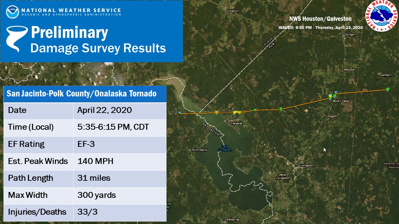
Since the weather is not terribly busy, let’s start with a couple housekeeping items today. First, the National Weather Service surveyed the damage from Wednesday’s tornado in Onalaska yesterday. They found that a tornado traveled from at least near Waterwood, on the west side of Lake Livingston through at least Barnes, in northeast Polk County.
Preliminary track and summary details of the Onalaska tornado from the NWS Houston. Click to enlarge. (NOAA)
That’s a little over 30 miles, though it could change as more reports are examined. The survey team found mostly EF-1 and EF-2 damage in Onalaska, but they did find low-end EF-3 damage in Paradise Acres, just north of Highway 190 on the northeast shore of Lake Livingston. Maximum winds were estimated to be 140 mph.
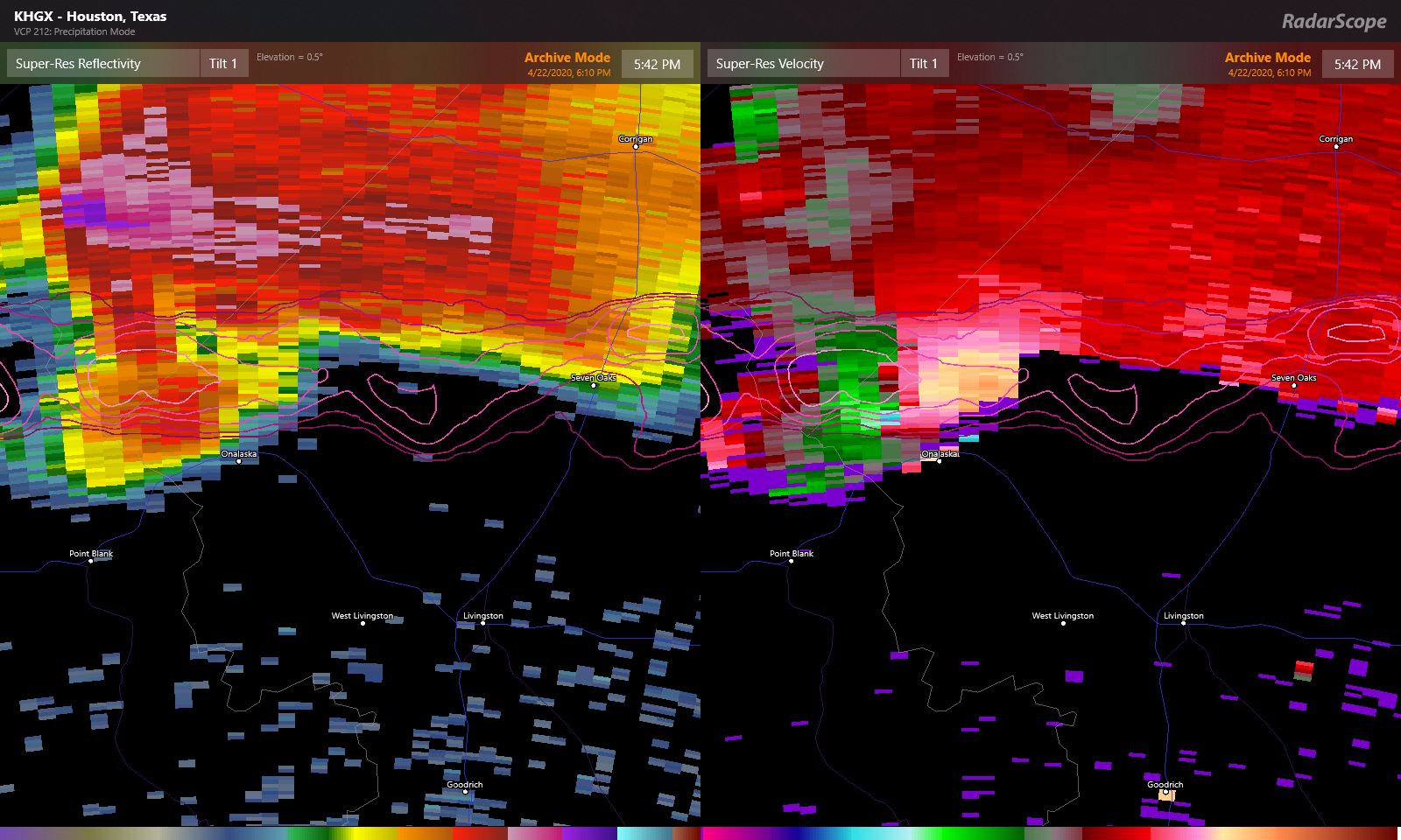
Radar image from around 5:40 PM Wednesday, as an EF-3 tornado was bearing down on Onalaska. (RadarScope)
We’ll update if any new significant findings emerge.
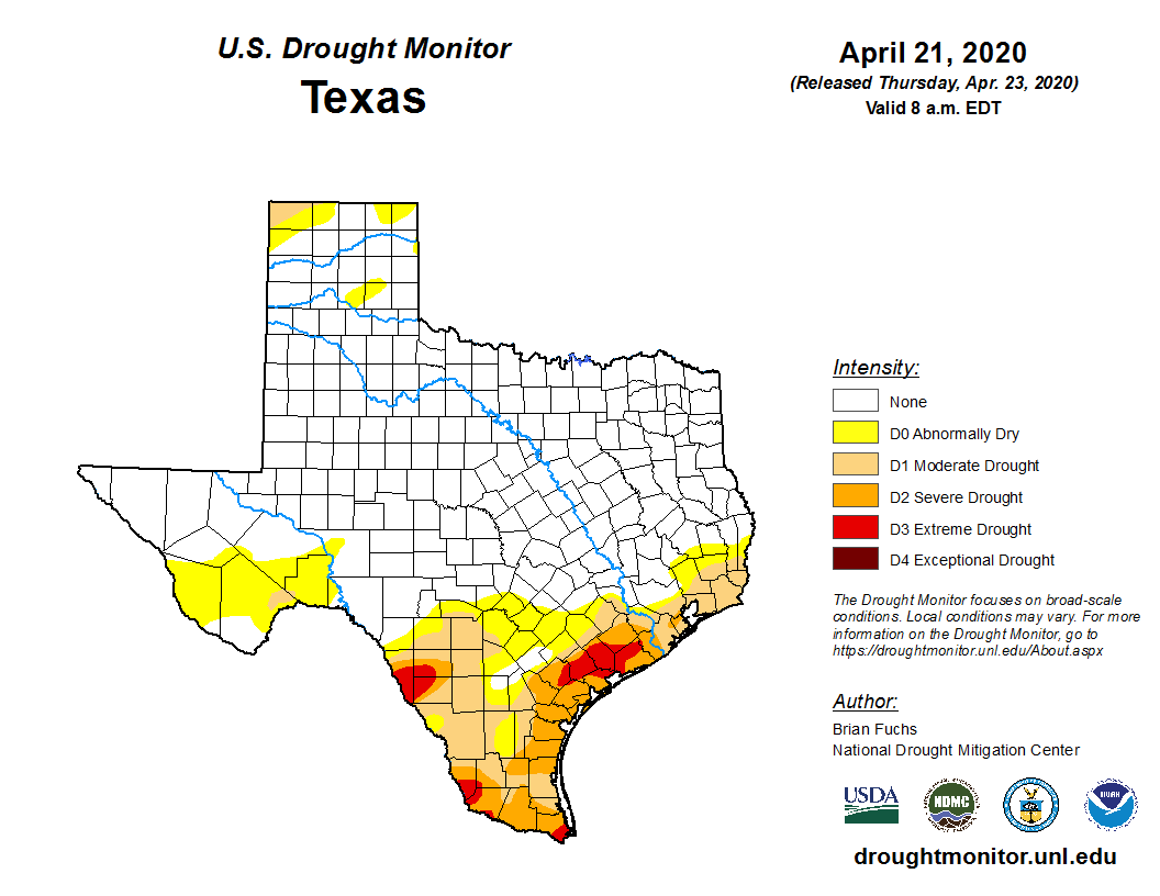
One of the other issues we have had that we’ve touched on from time to time, is dry weather. The latest drought monitor from yesterday shows the northern side of the Houston area mostly drought free, but steadily increasing drought conditions as you go south of the city.
Most of Texas is drought-free. For our area, drought steadily increases as you go south of I-10 or southeast of US-59. (US Drought Monitor)
The entire Gulf Coast from Texas to Florida, which has been dominated by a ridge of high pressure for most of the winter and spring, is under some kind of abnormally dry or drought condition. Until that stagnant pattern can break or the daily afternoon thunderstorms of summer fire up, we will probably continue to see most organized storms pass us by to the north. We will keep tabs on things and let you know if that does change of course.
Alright, onto the forecast.
Friday
Most areas are crystal clear this morning, but some patchy fog has shown up in a couple spots. Either way, that will clear and we should expect mostly sunshine today with highs making a run for 90° this afternoon.
As a cold front begins to approach the area this evening, it could be carrying some thunderstorms. Areas north of Houston, unfortunately, stand the best chance of seeing these. Those storms could be locally strong to severe north of Houston, but they should be quick moving and the main threats would be isolated damaging wind or hail. Storms should begin to weaken as they approach Houston, and the most likely areas to see rain this evening would be along or east of I-45.
Bottom line: With a cold front approaching this evening, don’t be shocked to see a little rain or hear some thunder for an hour or two.
What a week it has been. The last several days have been just fantastic as we prepare for the days of heat and humidity in summer. Onshore winds have returned however, and another drawn out period of unsettled weather begins today. For those yearning for rainfall, especially south and southwest of Houston, this looks to be another potentially frustrating event. We break it all down below.
Today & tonight
Clouds have become a little more widespread overnight and this morning, and today should see more clouds than sun for most areas. Look for showers to develop through the morning and into this afternoon as a cold front begins to approach from the north and west.
Showers should not be particularly heavy or significant, but a thunderstorm can’t be ruled out. There’s a good chance many of us may not see much of anything today, but have an umbrella at the ready if you’ll be out later today.
Clouds, warmer temperatures, and scattered showers with perhaps a thunderstorm will be the story today. (NWS Houston)
The front itself should wait to get through the Houston area until this evening. Shower chances should generally drop off tonight, and it will just be mostly cloudy with perhaps a little drizzle or mist in spots. It will be interesting to see what temperatures do behind the front. Like we saw last weekend, it got rather cool, so although I would expect us to only drop into the low-60s in Houston, we could see upper-50s in spots to the north overnight. Coastal areas may not get much below the upper-60s, as the front stalls nearby or just offshore.
Saturday
By later Saturday morning, our cold front should begin creeping back north as a warm front. With a disturbance passing by simultaneously, we should see showers and storms begin to break out across parts of the area. Initially the focus should be west of Houston, but it may move into the Houston area as the afternoon goes on. As has been the case recently, the heaviest rain chance may be to the north of Houston.
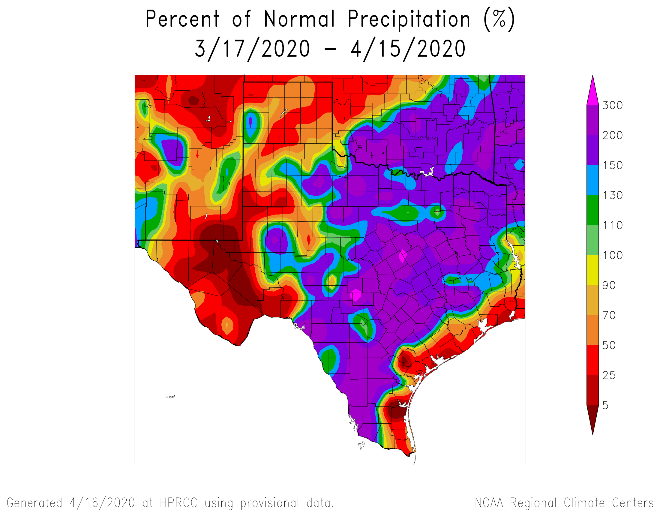
The last several storms tracking across the region have produced seriously mixed results for our area. In fact, if you just look at Highway 59/I-69, you can get two very different narratives on either side of the highway. West or north of 59 has been rainfall rich, with 150 to 200% of normal rain over the last month. That steadily drops to near 25% of normal at the coast on the other side of the highway. There’s nothing special about Highway 59, but it conveniently works as a boundary here.
30 day percent of normal precipitation across Texas has bisected our region with Montgomery County seeing 200% of normal rainfall, while Galveston has seen probably about 25% of normal.
The last few severe weather risks have also been fairly underwhelming in our area too, with a few exceptions. It’s important to understand that with these types of storm systems in our area, there a lot of things that have to come together to generate storms. This one looks to be no different. And yet again, the best chance for more rain will be to our north and west.
So look for scattered showers, thunderstorms, and downpours on Saturday. Many of you won’t see anything on Saturday, but some folks may see a shot of storms. Severe weather risk is low but not zero. If we do get storms going, look for strong winds or some hail to be the primary risks.
As far as temperatures go, look for us to warm into the 70s on Saturday afternoon.
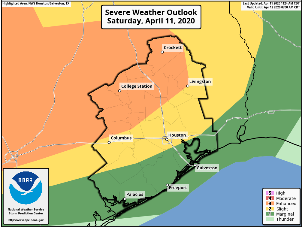
We just wanted to give a quick update today on the concerns regarding severe weather. We noted yesterday that there was still some uncertainty in details for today. The majority of the area experienced a really, really nice morning. As we march through the afternoon hours, showers or sprinkles are likely to begin developing. Per the National Weather Service and after looking at some near-term model data myself, it’s clear that the Houston area is in a “capped” environment this afternoon. We talk about the cap often, and basically that’s what helps Houston frequently avoid some of the more ballistic severe weather events that occur off to our north and west. So, assuming that the cap is likely to hold through the afternoon, we shouldn’t see much more than a few showers.
The exception to this could be north of I-10, farther from the Gulf and more likely to see the cap erode enough to allow for some heavier showers or storms late this afternoon or evening.
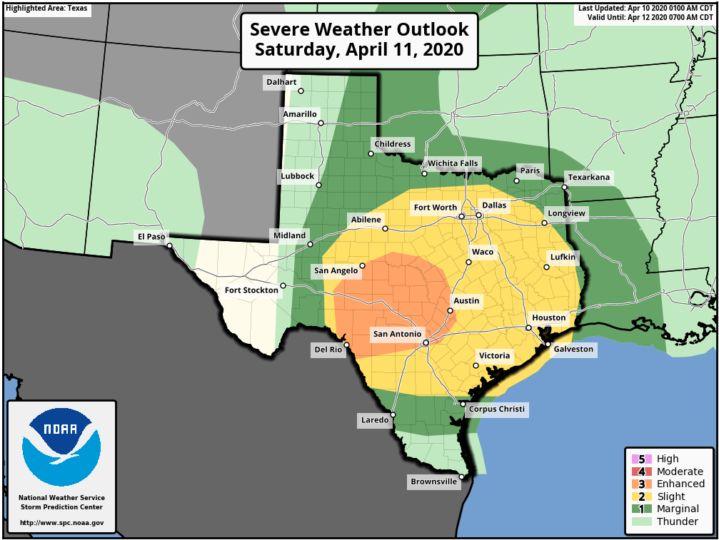
The risk for severe weather today and this evening is highest off to the north and west of most of the Houston metro area. (NOAA)
So, with all that in mind, you can see the Storm Prediction Center’s outlook here. The risk for severe weather generally will go up as you go north and west of the Houston metro area. The highest risk through this evening is probably along or northwest of a line between Crockett, College Station, and La Grange. That’s not to say we couldn’t see severe storms pop before midnight farther south and east; it just doesn’t seem super likely right now. So, keep tuned into the weather, but we aren’t real worried right now.
Overnight
Things do change a bit overnight. We enter into a slightly better and more supportive environment for thunderstorms to develop. But even then, I am still seeing some evidence of “capping” in the models over Houston. I think the general rule of thumb will be that we’ll see scattered showers and storms overnight. Most should be under control and many of us won’t see much of anything. As you go north and west of Houston, the chance that one or two of those storms could become severe increases. I would really watch the area west of San Antonio toward Del Rio closely tonight for potential of some pretty significant storms capable of producing large hail or tornadoes during the late evening and early overnight hours.
Those storms west of San Antonio are likely to congeal into a line of storms and move east along and north of I-10 overnight, arriving in the Houston area sometime around or after sunrise tomorrow morning. The main concern as those pass would be strong, gusty winds, but the chance of an embedded tornado is not zero. Again, the rule will be that the farther north you go, the more likely you see stronger storms. Some areas south of Houston may not even see much of anything overnight and Sunday morning. But the time we should be paying closest attention is probably from 5 or 6 AM through 9 AM or so.
Easter Sunday
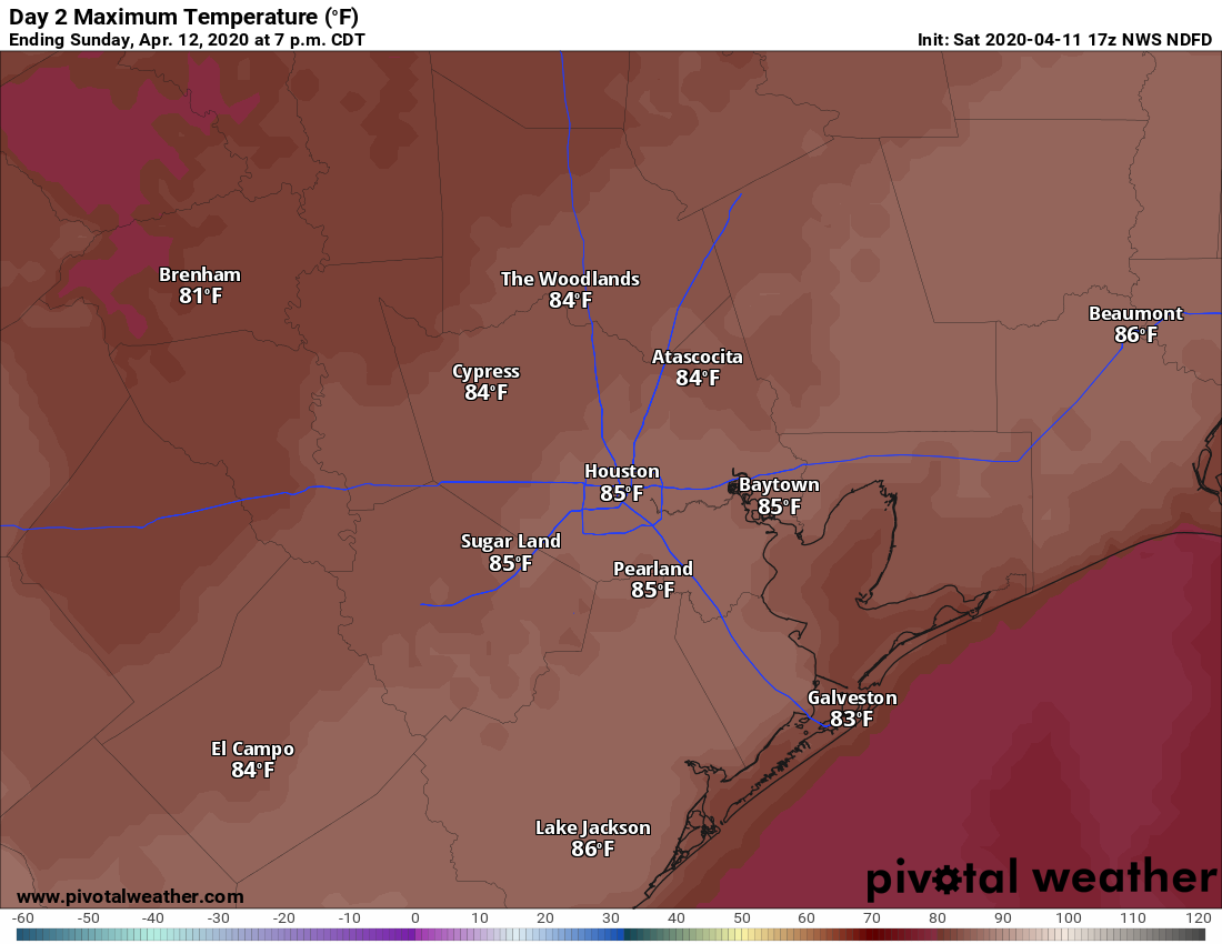
Once the showers pass off to our east on Sunday morning, we should see rapid clearing of skies by midday. Winds are going to begin to crank out of the west at 15 to 20 mph, with higher gusts, especially over the bays and near the coast. Temperatures will surge into the middle or upper-80s as humidity plummets. I wouldn’t rule out 90° tomorrow either for some folks. A windy, hot Easter afternoon.
Sunday afternoon will be windy and hot with plummeting humidity. A few locations could even be a little hotter than this Sunday afternoon. (Pivotal Weather)
The cold air arrives Sunday night, and by Monday morning we’ll be back in the 50s, struggling to get to 70 degrees Monday afternoon. More on that Monday.
Southeast severe weather
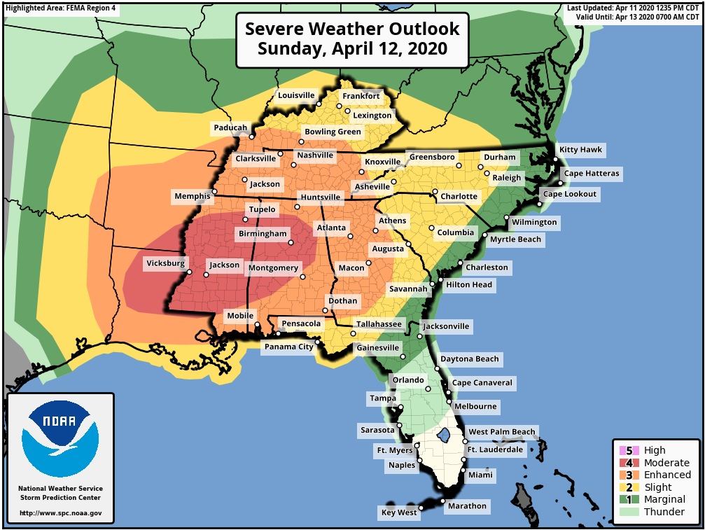
A quick PSA from us: While we aren’t expecting a lot of significant severe weather in our area tomorrow morning, there is a decent chance that this will be a very serious severe weather outbreak to our east. From northern Louisiana through much of Mississippi and Alabama into Georgia, and possibly Tennessee and the Carolinas, the potential exists for a significant tornado or severe weather outbreak tomorrow and tomorrow night into Monday morning.
A moderate risk for severe thunderstorms, including tornadoes is in place from northern Louisiana across the Southeast for Easter Sunday. (NOAA)
A moderate risk (4 out of 5) is in place for tomorrow’s activity across Louisiana, Mississippi, and Alabama. This could be upgraded to a high risk tomorrow if confidence increases in a potential tornado outbreak. If you have friends or relatives living east of here in any highlighted yellow, orange, or red area on the map above, please make sure they’re following the weather situation in their local area.
Last night was quite active in parts of the area. In other parts of the area? Yeah, it felt like a flop.
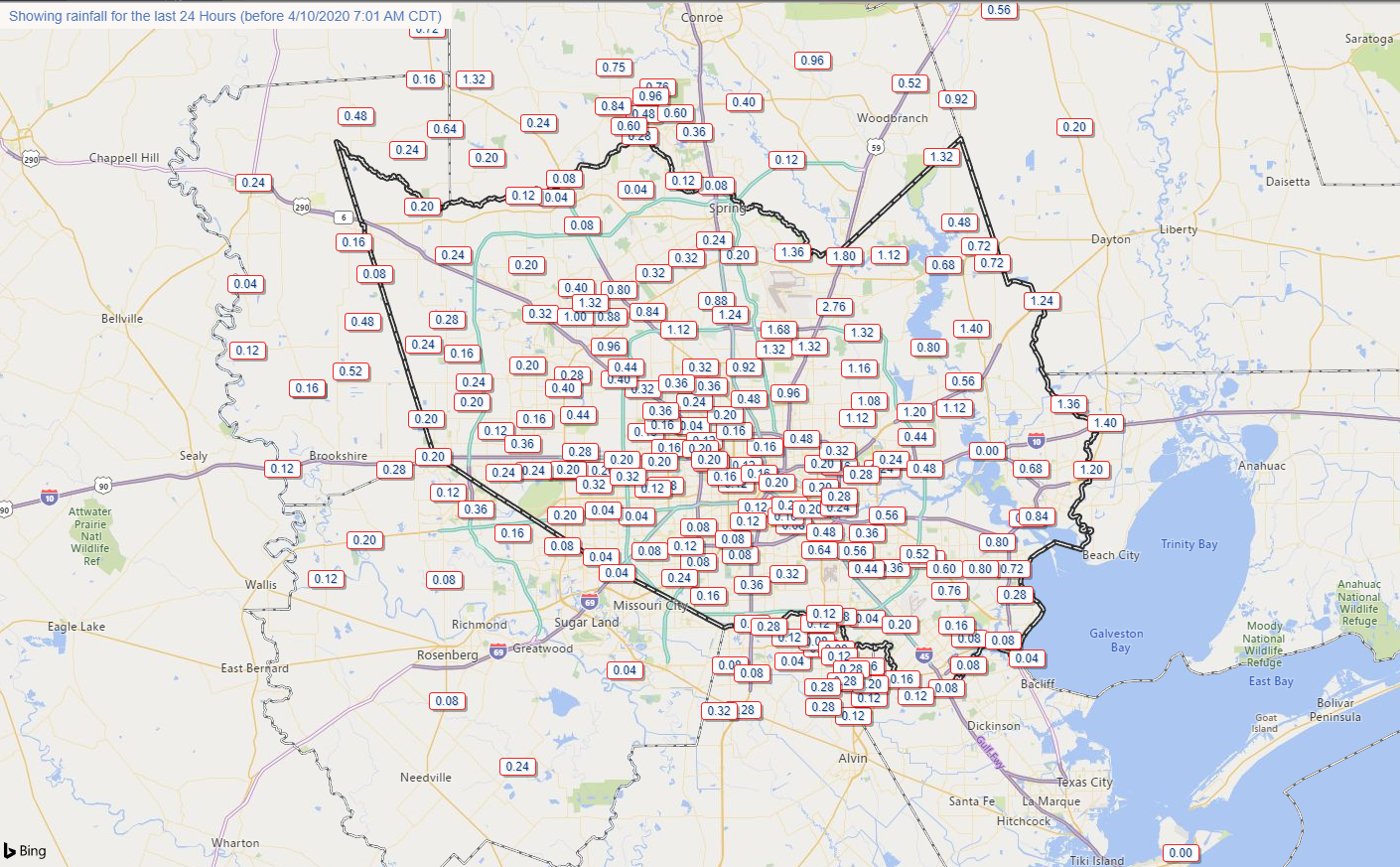
Rainfall amounts were widely variable across the region, with some places seeing minor amounts of rain and others seeing north of 2″. (Harris County Flood Control)
Rain totals were quite erratic. Southern areas saw low amounts. Northern areas saw variable amounts. A gage just east of IAH Airport between Will Clayton Parkway and the Beltway along Garners Bayou nearly received 3″ of rain. But that was very much the exception yesterday. Rain totals elsewhere were less than a quarter inch in many places like Tomball, Cypress, Katy, and Sugar Land. The Woodlands saw a pretty good storm, but even there, it moved fast enough that rain totals were generally under an inch.
Severe weather was not really an issue in the Houston area either. Most reports yesterday came from the Brazos Valley and back west toward Austin and even those were few.
Anyway, with that in the rear-view mirror, we can start talking about the next round.
Today
First off, today looks quiet. We will have clouds for the bulk of the day, but it will feel refreshing after yesterday’s record heat (91° at Hobby was a new record, 91° at Bush fell a degree short). Look for highs mostly in the 70s today. It will also be a good bit breezy at times with winds out of the east or northeast around 15 mph with higher gusts, especially over the bays and Gulf.
Saturday through Sunday morning
For Saturday, morning, lows will be in the low-60s or even upper-50s, but temperatures will rebound into the middle 70s through the day. An approaching warm front will send humidity up through the day as well.
The biggest question on Saturday revolves around rain and thunderstorms. Let’s work through this in order of likely outcomes. Scattered showers are likely Saturday morning and afternoon. Many of us may not see rain, but some of us will. Models differ in opinion on where rain will arrive, with a couple suggesting coastal areas and Houston will see a good deal of showers tomorrow morning. Others keep those areas mainly dry and focus development off to the north and west of Houston. We will call it scattered showers and go from there. A thunderstorm is also a good possibility too. For the most part, we do not expect significant severe weather Saturday morning or afternoon in Houston.
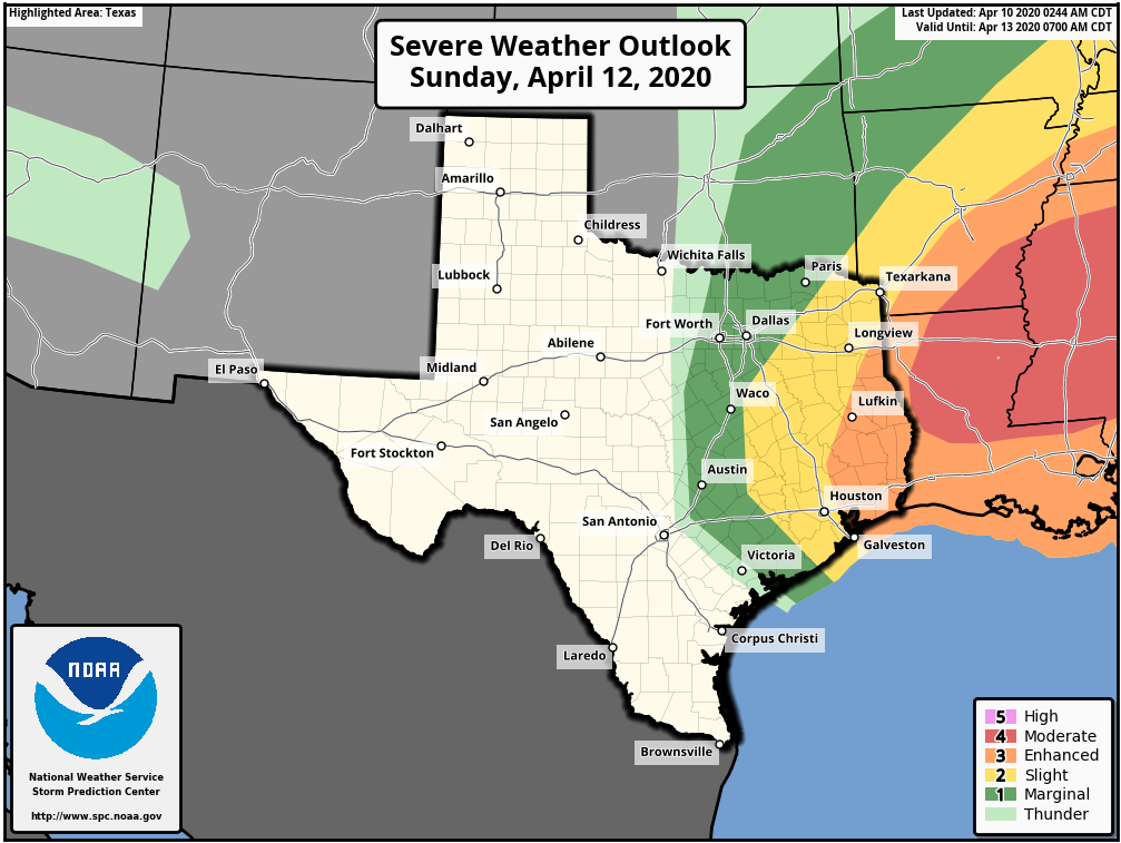
Severe weather on Saturday afternoon will probably begin in Hill Country or west of San Antonio toward Del Rio and the Rio Grande Valley.
Saturday’s severe weather outlook suggests storms will develop mostly in Hill Country during the afternoon and begin to move east Saturday evening. (NOAA)
Heading into Saturday night, with a warm front in the neighborhood and ample moisture in place with a strong disturbance approaching, that’s typically a recipe for thunderstorms to develop. There are still a lot of questions as to exactly how Saturday night is going to play out. There should be strong to severe thunderstorms in Central Texas moving into East Texas, especially north of I-10. We could see additional development of storms ahead of that off the Gulf. At this time, that looks more concerning east of the Houston area, more into Louisiana. But with a good bit of uncertainty still in play and a Sunday severe weather outlook that is still pretty aggressive nearby, I don’t want to rule anything out at this point.
Easter Sunday severe weather outlook shows risk increasing to the east of Houston, whereas most of our weather will be out of here by late morning. (NOAA)
Bottom line on Saturday night/Sunday early morning: Expect showers and potential for some thunderstorms. Some severe weather is possible, but odds may be highest north and east of Downtown Houston. Eric or myself will keep you posted this weekend if things get more serious.
There will be a couple boundaries pushing through Houston on Sunday. The boundary with storms should push out, ending the rain by 10-11 AM or so. The first cold front will follow around 12-2 PM or so. That will flip winds out of the west, and they should increase as well back to the 15 to 20 mph range, with higher gusts.