Houston officially topped off at 81° yesterday, our warmest February day since way back on February 6th, when we hit 82°. More importantly, we had some sunshine yesterday, which was a pleasant surprise. We won’t be seeing much more sun until Friday.
Today
Today is starting off cloudy inland and foggy along the coast. We probably won’t see much change in that situation through the day today.
In terms of rain chances today, those will be highest north of about The Woodlands, so from Navasota over to Conroe up through Huntsville and over toward Lake Livingston; basically along or north of Highway 105. Some of the rain could be heavy at times later this afternoon up that way, and thunder will be possible too. Closer to Houston or the coast, a few showers will be possible through this afternoon but they will probably not amount to much.
Oh, and it’s going to be a warm one again today. We should make another run toward 80 degrees this afternoon, but with more clouds than yesterday, we will probably end up a little short.
Tonight
The cold front will be located somewhere north and west of Houston early this evening, probably from about Lake Livingston through Conroe through about Sealy. Through the evening, the cold front will progress into and beyond Houston to about the coast by midnight or so. Look for scattered showers and a chance of thunderstorms tonight.
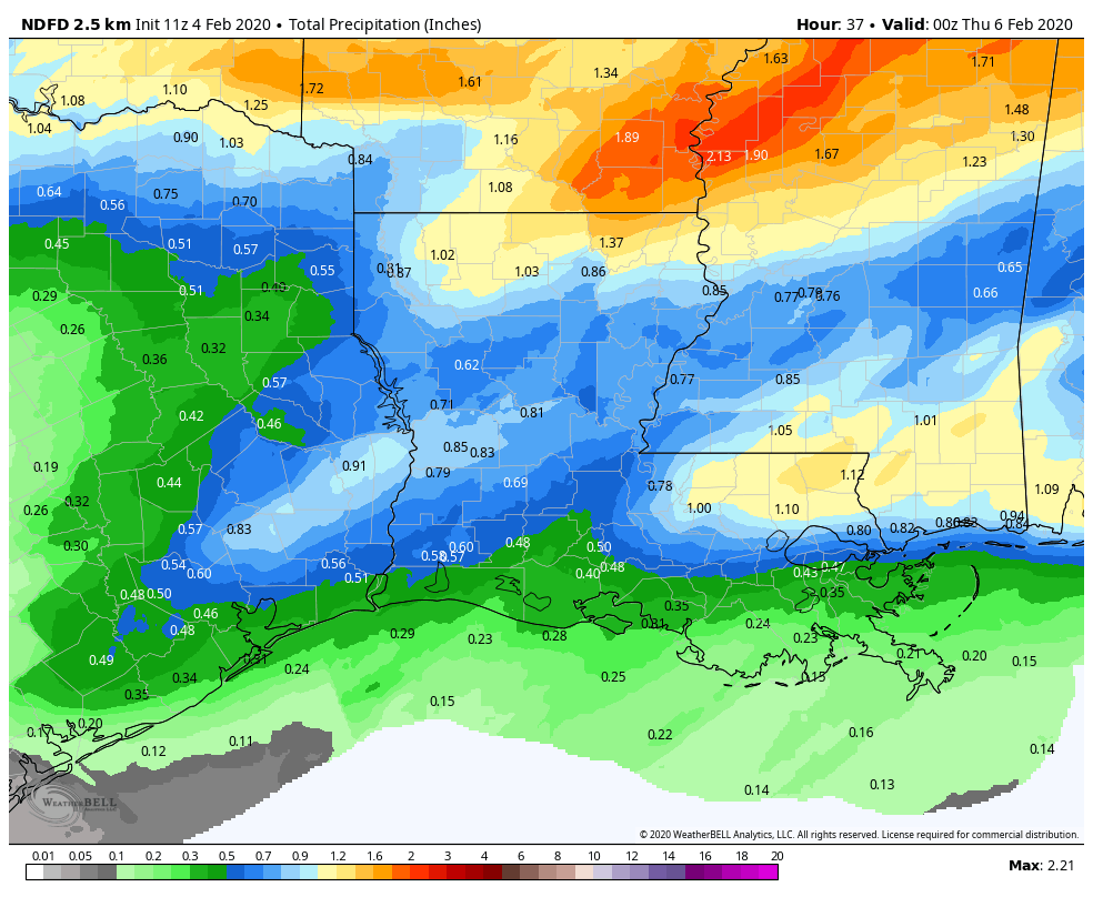
Rain totals will be highest today and tonight to the north of Houston. It is possible that some folks from I-10 southward may not even see a drop of rain. I would expect a range of 0.10 to 0.25 inches of rain on average along and south of I-10 through Wednesday morning, increasing to 1 to 2 inches or so north of Conroe. A couple spots up from Conroe or Huntsville over to Lake Livingston could see as much as 3 inches or so if we see slower moving, better organized thunderstorms later today and this evening.
Temperatures aren’t going to plummet behind this front, but they will drop about 10 degrees in its wake, from the 60s into the 50s this evening. By daybreak Wednesday, we should be in the low-50s or upper 40s from Houston north and mid- to upper-50s south.
Wednesday
Despite the front being offshore, Wednesday will be a cloudy day. Showers or light rain will be ongoing in parts of the area. The most sustained rainfall on Wednesday should again be along or north of Highway 105, so we’re talking Aggieland through Conroe. We could see upwards of another inch or so in those parts. Rain may fall steadier than today a bit farther south tomorrow, closer to Tomball or The Woodlands. But in the Houston area and points south, expect only occasional light rain, drizzle, or showers.
Temperatures are not really going anywhere tomorrow. We will probably finish the day within a couple degrees of where we start the day. So, dress for generally middle 50s, perhaps a bit milder south or colder north.