If the weather forecast going into next week holds, we may look back on this week as being one of the more important weeks of summer, because we needed some rain and most of us have received some.
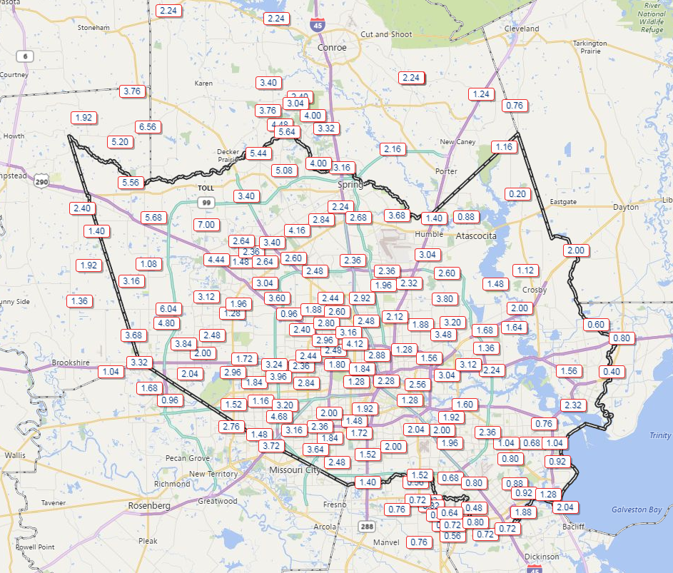
Rain totals over the last 7 days as reported by various Harris County Flood Control gauges. (Harris County Flood Control)
Yes, some areas have been mostly avoided, which is unfortunate, but regionally, at least we were able to ease the potential descent into drought. We have a very repetitive forecast over the next week or so.
Today & Saturday
Both days will carry at least a chance of showers. Radar has a couple offshore showers this morning, but nothing too significant. I expect we’ll see showers kick up later this morning (after 9-10 AM) near the coast, then spread inland this afternoon. Coverage will be similar to a little less than what we saw yesterday. Some of you may pick up a quick quarter to half inch of rain with thunder. Others will again listen longingly to distant rumbles of thunder.
Saturday should see slightly less coverage of storms, especially west of US-59. The better chances for showers tomorrow will be east of US-59, especially as you get closer to Beaumont/Port Arthur and Lake Charles.
Temperatures today and tomorrow will top off around 90 or in the lower 90s. And they may also be the coolest days of the next 7-10.
As Eric mentioned yesterday, for some in the Houston area, rain has been missing for a good while. And it looks like the next couple days will extend that streak. By Sunday and next week, however, a few subtle changes will at least allow us to at least mention showers again. But it is unlikely that all of us will see rain.
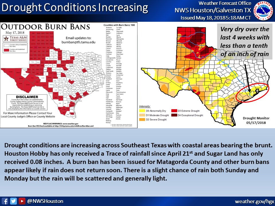
Dry conditions are expanding in Southeast Texas. (NWS Houston)
A quick side note here: I’ve seen some people mention how this is reminding them of 2011 again. We technically aren’t in drought yet. And at this point in 2011, the drought in Southeast Texas was orders of magnitude worse than it is now. So we have a long, long way to go before we’re at that level. Be aware that we have dry conditions, be smart and conscious about burn bans around Texas, and give some thought about conserving water where you can. But, no, this is not a 2011 redux as of mid-May 2018. We need some rain though.
Let’s get into the forecast details.
Today & Saturday
I don’t foresee much change in the overall weather pattern the next two days. Both today and tomorrow should be mainly sunny and hot. After hitting 96° yesterday, expect mid 90s this afternoon and lower 90s on Saturday afternoon. Nighttime lows tonight will drop into the lower 70s. Humidity should increase a little bit above where it has been for the last few days.
Sunday through Tuesday
As onshore flow returns, moisture will come ashore also. Precipitable water (a good measure of how much moisture is available for thunderstorms) is around an inch right now, a little bit below average for this time of year. By Sunday that rises to around 1.5 inches, or around normal. We might be able to stretch it a little bit higher Monday and Tuesday, but for all intents and purposes, we’re just getting back to average here. That should mean that with daytime heating we will see at least a few hit or miss downpours develop each afternoon, especially Monday and Tuesday. But widespread soaking rain seems highly unlikely.
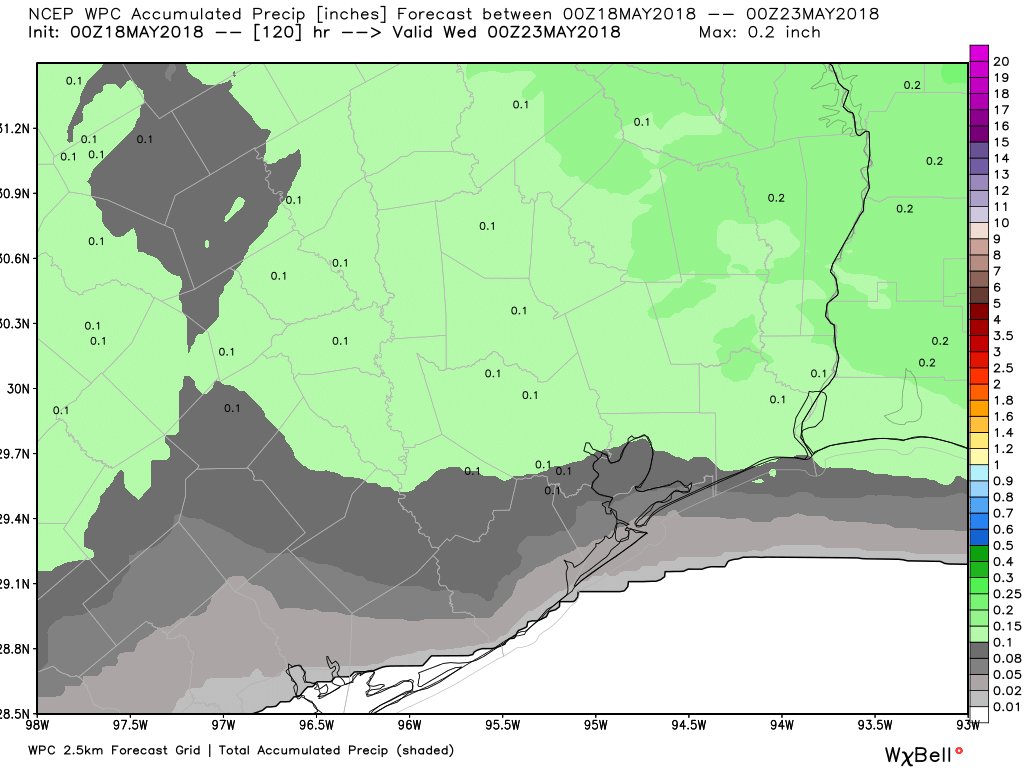
The NWS Weather Prediction Center rainfall forecast over Southeast Texas shows an average of around a tenth of an inch through Tuesday. Showers will be limited, despite a more typical setup. (Weather Bell/NWS)
I don’t think everyone will see rain early next week. Hopefully most of us see a little something here, but I’m not overly optimistic.
All three days will see high temperatures around 90 degrees, give or take a couple degrees. Our evenings will be sultry, with lows in the mid 70s, but perhaps close to 80 degrees in Galveston.
We weren’t lying about this week having some stunning weather. Yesterday was about as close to perfect as you can script here in Houston. It’s certainly worth touting to our neighbors in the North, where winter has just not found a way to relent. Here, however, it’s been great. Through the first 19 days of April, we’re averaging 77.2° for a high and about 56.2° for a low. Compare that to the same period last April, when we averaged 81.4 for a high and 61.2° for a low. This month has been cooler and much more comfortable than April 2017. Can we keep the good times rolling? I think so, but it will get at least a little warmer as we go. First, let’s get through Saturday.
Today
We’re starting today with a good deal of clouds on the west side of the area, and more of a mixed sky on the east side. We’ll call today partly sunny, but it may be a case of more clouds than anything. With the clouds, temperatures are held down, and while we’ll call it lower 70s today, I wouldn’t be shocked to see a few places not get out of the middle to upper 60s if clouds hang in all day.
Tonight through Sunday
Clouds continue tonight. A warm front will approach our region from the south. As it does so, we’ll probably see at least a few showers break out or a bit of light rain and drizzle. The best chance for that to happen will be south and west of Houston. Low temperatures won’t go too far tonight and should bottom out in the lower 60s.
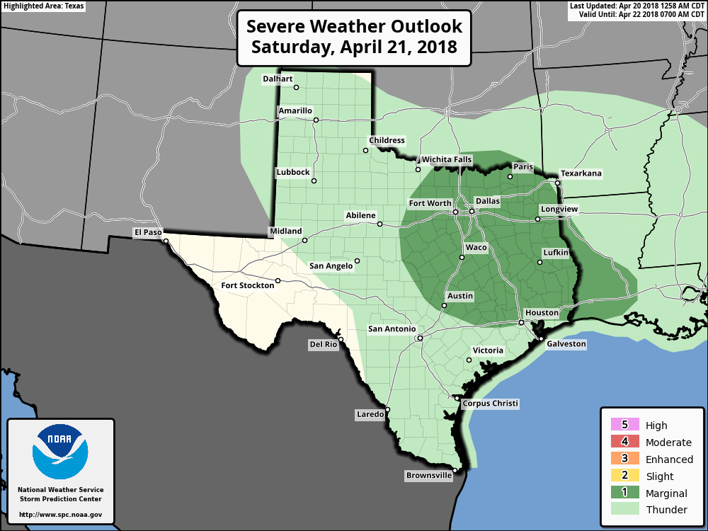
No change in the severe weather outlook for Saturday staying on the low end of things. (NOAA/SPC)
On Saturday, expect showers or light rain at times. It’s probably not a total washout, but Saturday’s not going to be a great day. Then, as a disturbance ahead of our next cold front approaches, we’ll see a chance of thunderstorms begin to increase later in the afternoon and evening.
Good Friday morning, and here we go again with another cold front and storm chances. Fortunately, while we can’t entirely rule out some severe weather, it seems fairly unlikely for most of us. We’ll see lingering clouds Saturday, but we’re set up for some beautiful weather Sunday.
Today
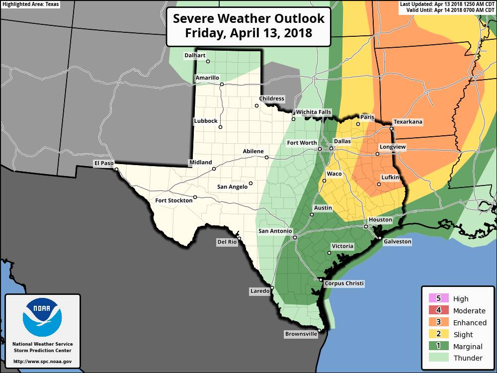
We’re socked in with clouds this morning, indicative of a lot of moisture in place at low levels of the atmosphere. This is all basically “trapped” under a capping inversion (“the cap”) that we often talk about this time of year. What this will likely do is inhibit thunderstorm development over much of the region during the day today, but it will keep things somewhat dreary with clouds and occasional showers or light rain in spots. While we can’t entirely rule out a stray storm north of the Houston area, any significant severe weather threat this afternoon will likely stay way to our north, closer to Texarkana.
While we can’t entirely rule out an isolated severe thunderstorm this afternoon in northern parts of the area, the best chances for severe weather are closer to Texarkana, Shreveport, and up into Arkansas. (NWS SPC)
It will remain fairly breezy, with gusty onshore winds sustained around 10-20 mph, with higher gusts, especially near the coast.
Tonight & Saturday
As we go into this evening, the cold front will begin to approach the area from the north and west. Right now, I would expect a fairly well organized band of showers and storms with it as it moves through the region around or after midnight. So expect to hear raindrops at some point tonight into Saturday early morning. Will we see severe weather? It’s possible, but I don’t think all the ingredients are quite there for it to occur. If we were to see storms go severe overnight, I think the primary threat would be strong winds. Still, even without severe weather lightning, thunder, gusty winds, and briefly heavy rain are all possible. Total rainfall will be under an inch for most of the region, with some areas likely seeing well under a half-inch.
The front pushes offshore Saturday morning. Expect continued clouds and perhaps even a few lingering showers through about midday Saturday. We should then see slow clearing. Winds will stay gusty but flip from onshore to offshore. Expect those to gradually diminish Saturday afternoon.
The tricky aspect to Saturday’s forecast will be temperatures. They will drop off behind the front, with Saturday morning lows bottoming out in the low 60s at the coast and mid to upper 50s inland (even a bit cooler in the Brazos Valley or up toward Huntsville). But it gets challenging on Saturday afternoon. If cloud cover and showers persist beyond midday and into mid-afternoon, we’ll likely see temperatures hold in the upper 50s to low 60s most of the day. However, if we see clearing and get a good bit of sunshine Saturday afternoon, look for temps to rebound to the upper 60s.