In brief: We recap Tuesday’s torrid temperatures, where parts of Houston hit the century mark and talk about how this late September fling with sizzling temperatures should soon start to wane. Next week things start to get even more interesting.
A September to not remember
Houston’s high temperature on Tuesday hit 99 degrees—I mean come on already—at Bush Intercontinental Airport. This is just a single, solitary degree short of the all-time record high for the day. We are going to have one more day today in the upper 90s with high humidity, and we will surely give the record high for September 23 (97 degrees) a run for its money. At a time when high temperatures normally start to drift downward to 90 degrees, or even below, we have remained consistently in the mid- to upper-90s. Will summer ever go?
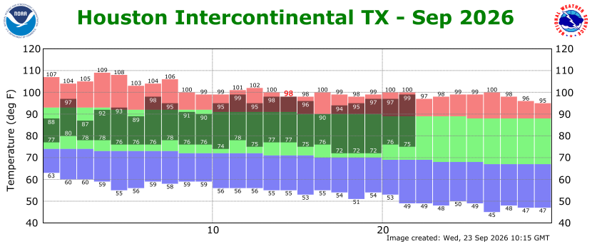
The answer is yes, albeit slowly. We are going to get a weak, backdoor front on Thursday. This will help with humidity a little bit. Then, I’m reasonably confident that we’re going to see another front during the middle of next week, although it remains to be determined in terms of how strong it will be. Regardless I do think that we are just about done with this relentless pattern of daily highs in the upper 90s and lows in the upper 70s.
Wednesday
But not today. With high pressure still in place, expect a sunny day with highs in the mid- to upper-90s across the region. We could see a few isolated showers and thunderstorms this afternoon and early evening along with daytime heating, but your overall chances are very low. Lows tonight should drop into the upper 70s in Houston.
Thursday
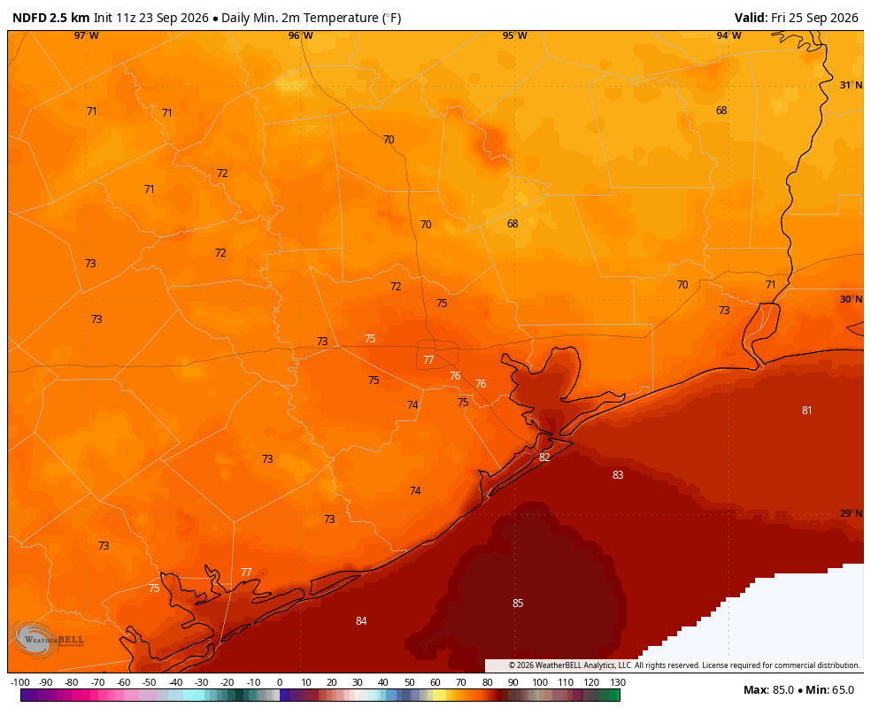
We will start to see some slightly drier air backdoor into the region from the northeast on Thursday, likely pushing dewpoints into the lower 60s. Daytime highs will still get into the mid-90s, and sunshine will still prevail, but humidity will be a touch lower. This should allow low temperatures on Thursday night to drop into the mid-70s for most of the region.
Friday
With slightly lower humidity, Friday morning should feel pretty pleasant (although certainly not like crisp fall weather). Highs should still reach the low- to mid-90s on Friday, with another modestly cooler night in the 70s.
Saturday and Sunday
Highs this weekend will generally in the low- to mid-90s with sunny skies and a fair bit of humidity. At least we should be several degrees below record highs. Overnight lows will be in the 70s. Rain chances are near zero, so plan outdoor activities with confidence.
Next week
Monday likely brings more of the same, but by Tuesday or Wednesday the breakdown of high pressure and approach of an upper-level low pressure system should bring increased rain chances. This should also bring some more cloud cover, knocking highs down to around 90 degrees. How much rain will we get in the middle of next week? Difficult to say for sure, but probably in the ballpark of 1 to 3 inches. After this some kind of front is likely (we are not 100 percent guaranteeing this yet, sorry) to move into the region. This has a decent chance of bringing us our first nights in the 60s since late spring, but again the details are to be determined. I don’t want to make any false promises.
