After a stunning Sunday, we’ll now see the return of some clouds today, and as early as tonight some healthy rain chances. Most of this week looks pretty gray, although there’s a chance of sunshine toward the Friday or Saturday period. Unfortunately, the forecast from Thursday on is fairly uncertain at this point.
Monday
Skies remain somewhat clear this morning for parts of Houston, and we’ll see at least partly sunny skies for most of today, as highs warm into the mid-60s across Houston. However, change will be on the way as the high pressure system overhead moves away, and winds begin to return from the east and southeast. With this returning moisture, a few scattered showers will be possible near the coast this afternoon and early evening.
Rodeo forecast
 Every weekday for the next three weeks, we’re going to offer Rodeo outlooks for people going to the concert. (Tonight, I’ll be among them, as Mrs. Space City Weather is a big Kasey Musgraves fan.) We’ll see temperatures of about 60 degrees at 6pm, with partly to mostly cloudy skies, and 10mph easterly winds. We can’t entirely rule out rain chances, but they’re probably around 10 percent for central Houston. After the show, temperatures will still be in the upper 50s, but the chance of scattered showers will be better, probably closer to 30 percent. Any rain should be light.
Tuesday
This looks like a wet and gray day. Highs will get into the mid- to upper-60s, and the combination of warmer air, low pressure, and ample moisture should lead to on- and off-again (mostly) light to moderate rain showers. All told, accumulations for most should be well under one-half inch, but a some areas may see a bit more. We also can’t rule out a few pockets of hail. The healthy rain chances should persist into Tuesday night, when lows for most won’t fall below 60.

Wednesday
We may see a bit of clearing skies on Wednesday, and depending on how much sunshine breaks through during the afternoon this will be a warm day, with highs in the mid-70s to possibly 80 degrees. Rain chances are probably around 20 percent.
Thursday, Friday, and Saturday
The end of the week is kind of a mess at this point to try and forecast—sorry. The first point of uncertainty is whether a relatively weak cold front that approaches the region on Thursday stalls, or pushes through. The second point of uncertainty is the timing of a second, stronger cold front on Saturday.
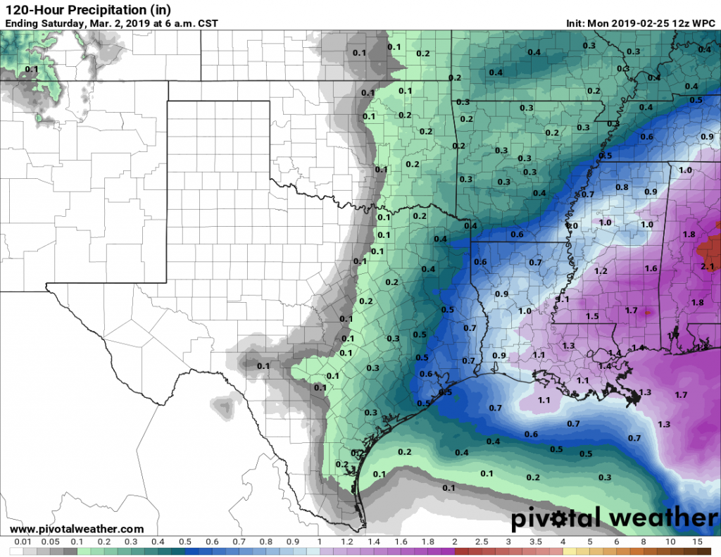
For now, we’ll go with mostly cloudy skies on Thursday, and a chance of rain during the daytime and evening. If the front makes it (and I’m betting it probably will), then Friday and part of Saturday have a chance to be pretty nice, with partly sunny skies and highs in the 60s or 70s.
Whenever the second front comes through on Saturday, we’ll see a significant cooldown, with highs in the upper 40s or 50s for a few days, mostly cloudy skies, and a chance of light rain persisting from Sunday onward. A freeze seems unlikely, however, even for the northern suburbs of Houston.
Can we start to get some guesses/guidance for The Woodlands Marathon on Saturday morning?
Hi Jeff. As noted in this morning’s post, there’s a lot of uncertainty. Right now I’d go with lows somewhere in the 50s, with maybe a bit of rain, maybe not.