In brief: Showers and a few thunderstorms return to the forecast today in Houston. A stronger line of storms will move through the area tonight, likely with lightning in the middle of the night. So Christmas morning could start with a bang. Most of the holiday should be fine, weather-wise. Expect mild temperatures for the remainder of the year.
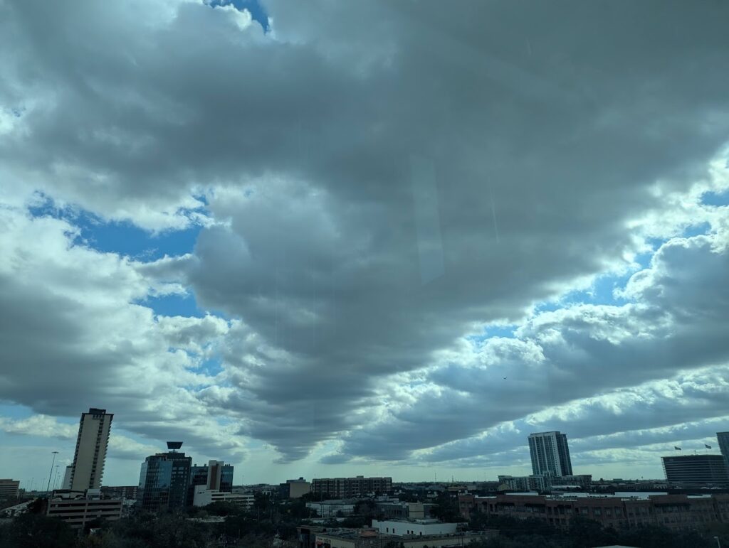
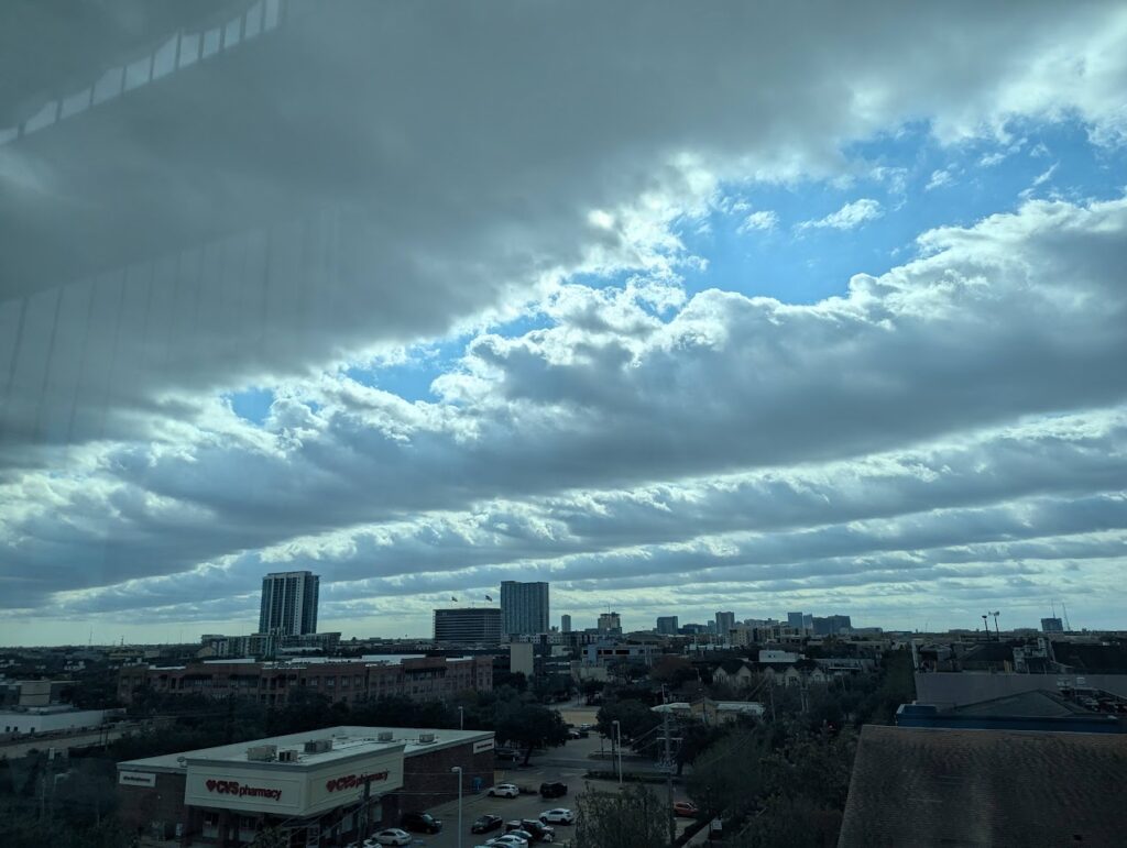
Clouds streets above Houston streets
Tory Gattis sent in the following photos yesterday, which he observed over Midtown in Houston. These are fairly low lying in the sky, so they’re stratocumulus clouds. The straight-line nature of the clouds is colloquially known as cloud streets, and more formally as horizontal convective rolls. The precise reason why they form is actually not particularly well understood, but they sure are pretty to look at. We will see more clouds today, but they are likely to be of a more ominous nature.
Today, tonight, and Christmas
Houston’s weather will turn more dynamic this morning as an upper-level disturbance approaches the area. Scattered showers and thunderstorms will be possible today, with the potential for some slightly more organized activity this evening. High temperatures today will reach the mid-70s, with mostly cloudy skies. Winds will be light, from the southeast. All in all, if you can dodge a few showers and storms, conditions today should not be too disruptive.
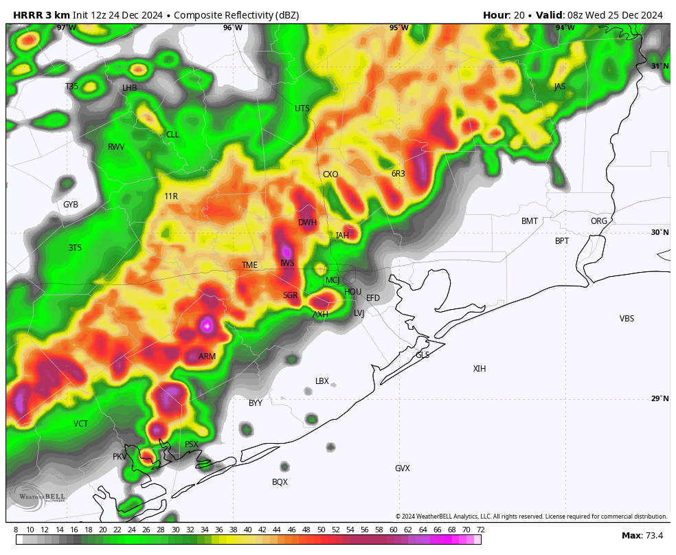
However the story could be different tonight, as an organized line of showers and thunderstorms marches down into Houston from the northwest. I expect this line of storms, likely with a fair bit of lightning, to reach areas north and west of Houston (i.e. Katy and The Woodlands) by just before or around midnight, give or take. It should then push through the Houston metro area between midnight and sunrise on Christmas Day. Some of our latest modeling indicates this may be a rather noisy passage, with briefly heavy rainfall and lots of lightning. If Santa’s coming and going doesn’t wake the dogs, these storms probably will. Damaging winds are possible, as well as a slight chance of hail. Most areas should pick up 1 to 2 inches of rain, with some higher bullseyes.
A simulated radar image shows storms moving into Houston at 2 am CT on Christmas morning. (Weather Bell)
The good news is that the storms should be off the coast and off to the east of the Houston metro area by fairly early on Christmas Day morning. The storms will drag a weak front into the area, so expect high temperatures in the lower 70s on Christmas, with slightly drier air. Some additional light, scattered showers will be possible with partly to mostly cloudy skies, however I think the rain will be over for most. Lows on Wednesday night will drop into the upper 50s to 60 degrees.
Thursday and Friday
The front won’t last long, and with a soggy atmosphere in place expect warm days in the mid-70s to end the holiday week. Skies will be partly to mostly cloudy, and both of these days and nights will have a decent chance of rainfall. These showers should be less explosive than those expected on Christmas morning, and accumulations far less.
Saturday and Sunday
We should see more sunshine this weekend, although we can’t rule out a few showers on Saturday morning ahead of another weak front. Saturday should be nice, with slightly drier air, and nighttime temperatures falling into the 50s. Sunday should also be sunny, with moderately drier air, and highs in the mid-70s. Rain chances are near zero.
Next week
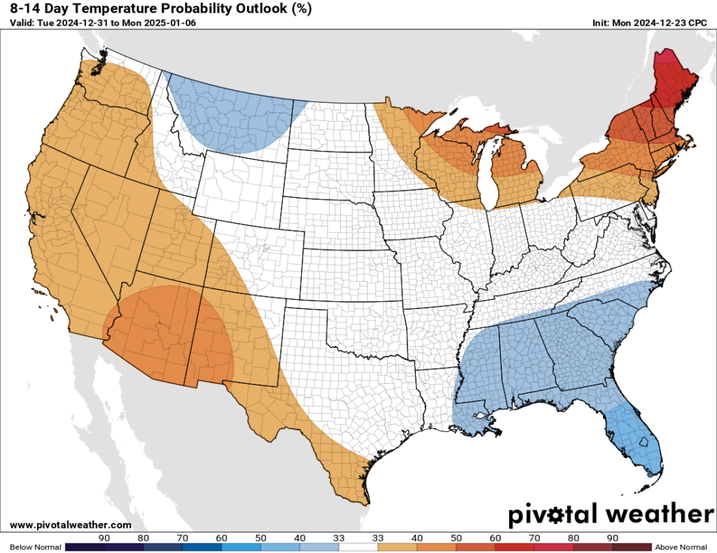
We probably will see the return of a warmer, more southerly flow early next week. We’ll likely also see a slight chance of showers at well. At some point, perhaps on New Year’s Eve, or New Year’s Day, a much stronger front will arrive. This should bring us seasonal weather for 2025, starting the year off on a winter-like note. Details to come.
Houston’s temperatures will turn more seasonal in early 2025. (Pivotal Weather)
Merry Christmas to all!
Please do be aware of the potential for storms tonight and early tomorrow. We’ll be keeping an eye on things, and if they look more dramatic than your typical Houston thunderstorms, we will update the site later today. However, if the forecast stays on track we probably will take Christmas Day off from posting. So please have a wonderful day.
Yeah, we know, we know. There was no Q&A in November. We really have no excuse, other than inertia and maybe a food coma late in the month.
Yeah, that’s it: Blame the turkeys!
Anyway, that was then and this is now. Here’s our December Q&A all wrapped up with a pretty bow for the holidays. If you’ve got a question about the weather you’d like answered, drop it in the comments, or hit the Contact link at the top right of the page.
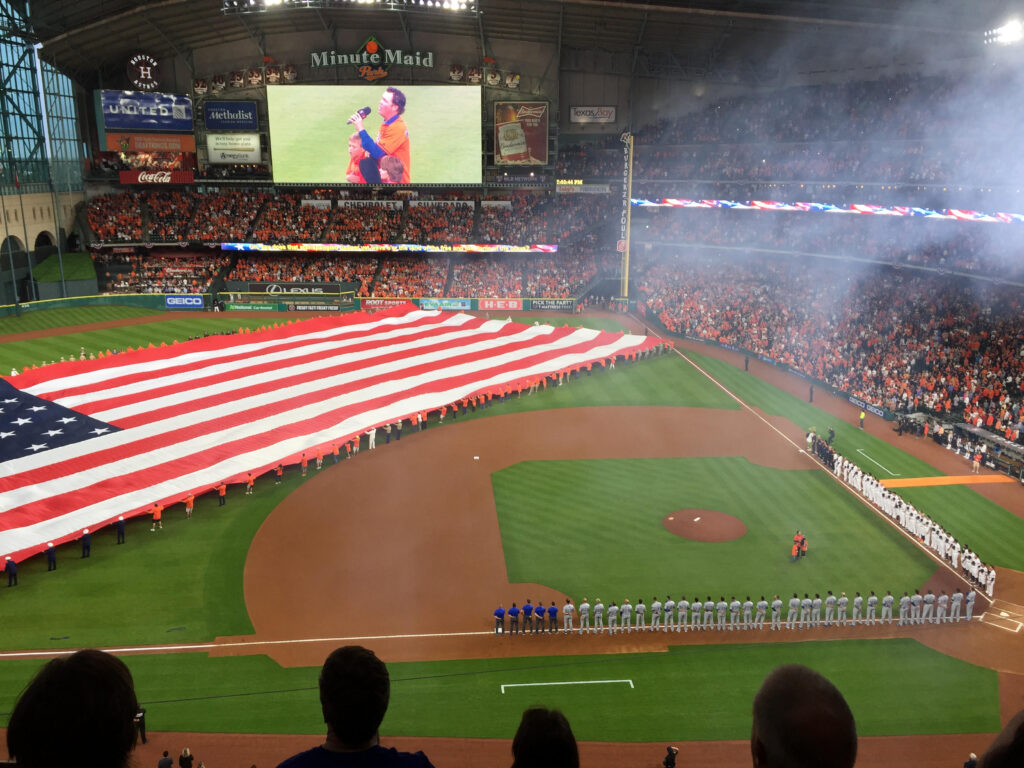
Q. On Sept. 20th, my family went to an Astros game, where 3-4 home runs were hit by Houston. Of course, the train gets moving and there’s the cannon/fireworks. Eventually, a “cloud” forms inside Minute Maid Park. My daughter, Winter, was fascinated. So how do clouds form? And how did a “cloud” form in Minute Maid?
A. The reader above told a good story about this whole experience and how it fascinated their daughter, which we trimmed down for length. It’s a good pair of questions! First, let’s talk about soon-to-be Daikin Park (so weird). We’ve all seen it at a game where the Astros do anything. The pyrotechnics go off and the “cloud” usually hangs around at some fairly consistent height.
Opening Day 2016 with pyrotechnics. (Lanza)
So what’s the deal? Well, Minute Maid Park is mostly an indoor ballpark, so the cloud stays inside and just gradually disperses. But sometimes that process takes a little while. The reason is likely because MMP is acting like its own little atmosphere. As you go up in altitude, the air typically gets colder, right? Well since MMP is indoors, and the A/C is always running, that cold air actually sinks. Hot air rises, denser cold air sinks. So within MMP, you have setup what we call a temperature inversion where it’s actually warmer as you go up in altitude.
Sit in the nosebleed section of the ballpark for one game and then in the front row downstairs in another and you’ll notice a bit of a comfort difference. Unless you had the ability to sample the interior “atmosphere” of the ballpark, I’m not sure at what height that inversion would occur, but it probably varies from game to game depending on the ambient temperature outside and how the A/C is running inside. So smoke from pyrotechnics probably gets “trapped” under that inversion and just sort of stratifies and lingers. This is a microcosm of what occurs in places like California’s Central Valley (tule fog) or in the Salt Lake City area in Utah. Cold air gets trapped in a valley, and a steep inversion forms and pollution and clouds and fog are all trapped under that inversion.
So, how does a cloud form? Well, the ballpark “cloud” aside, an actual cloud needs two basic ingredients: Rising air and moisture. Moisture evaporates from the ground, lakes, oceans, etc. As it does so, it turns from liquid to gas, or water vapor. That vapor rises, and at a certain point, when the air cools enough, it can no longer hold that moisture, so it has to convert back to a liquid or solid. For a cloud, the air cools, condenses, and you are seeing the formation of liquid or ice crystals on what we call condensation nuclei. This can be anything from dust to salt from the ocean to volcanic ash. Earth is big, and there is lots of stuff floating around suspended in the atmosphere. When this process occurs, we “see” the cloud.
I’ll point you to this NASA site for more information. No need to rewrite an already good explanation! There’s also a link at the bottom to an experiment you can run to form your own cloud in a bottle!
– Matt
Q. I have appreciated Matt and Eric’s weather forecasting and coverage for several years. I have a 7th-grade son who over the last year has become very interested in weather and has expressed an interest in becoming a meteorologist in the future. He followed the Atlantic and Pacific hurricane/typhoon information this season and even looked at websites that show various weather forecasting models. I say that just to confirm his strong interest in this science. I just wanted to ask if it would be possible to get any kind of feedback on things to know at this point as we begin to explore this career and even possibly what universities we could look at that have strong meteorology programs.
A. There are so many paths into meteorology and at your son’s age, I would just encourage his curiosity at this point. He should continue to look at weather forecasting models and get a sense of when they’re accurate, and when they’re not. During hurricane season I encourage him to follow the National Hurricane Center and read their forecast discussions. There’s a lot of good and understandable information there. The Tropical Tidbits YouTube channel is also very informative and, again, something he should be able to digest. For a little bit more of an academic perspective, the standard introductory textbook is Meteorology Today, and it is available online if you don’t want to find a used copy.
Given the rapid advances in AI weather modeling it is a little bit difficult to predict what the field will look like five or 10 years from now. But as long as your son has a good grasp on the fundamentals, and can communicate with his audience (whether it’s in videos, reports, or whatever) than he should be well suited for success in forecasting. I have found that it is as important to be able to communicate your findings as it is to be able to make a credible forecast. So encourage him to write as well!
– Eric
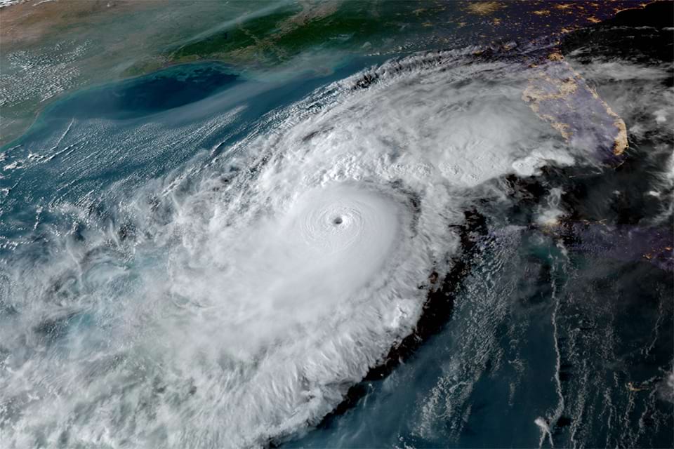
Q: My sister lives in St. Petersburg, Fla., and this year bought a home there facing the Gulf. (Bad timing!) When Hurricane Milton came through, it went in just south of them and they had less damage than Hurricane Helene just before, which passed by them to the west. I know the “dirty” side of a hurricane is on its right side, but what happens when a storm like Milton comes ashore, moving directly west-to-east, rather than south-to-north like most Gulf storms. Is the dirty side then to the south?
A: This is actually a question we get often. During hurricane season we usually tell people not to necessarily focus on the exact track of the storm because the impacts of the storm usually extend far from the center. Well, for certain impacts, like storm surge, the exact track of the storm can matter a LOT!
In Florida’s case, specifically Tampa, we’ve now seen multiple instances of why storm track is so critical. Storms like Idalia last year caused some moderate flooding around Tampa, but Helene was much bigger and stronger this year, thus it caused much more significant flooding because Tampa was south of the storm receiving winds out of the west, which pushed the Gulf water into Tampa Bay.
When Milton hit, although Tampa saw some rough wind and flooding from rain, they did not see much surge. Why? Because Milton went south. Winds in Tampa were out of the east and northeast, which actually pushes the Gulf away from Tampa. Back during Irma and Ian, Tampa Bay saw such wind out of the northeast that Tampa Bay actually drained out and people were (unwisely) walking “in” the bay! Both those storms missed Tampa, again to the south. So for Tampa specifically, it’s all about geography and exact storm track.
An image of Hurricane Milton approaching Florida, as seen from NOAA’s GOES-16 satellite at 6:30 p.m. EDT on October 8, 2024. ( NOAA)
But because of how the earth and atmosphere work, the “dirty” side with the strongest winds and worst hurricane conditions will always be the northeast quadrant of the storm. The implication for us in Houston? A storm coming into our south, like Beryl caused impressive storm surge in Galveston and Surfside Beach. A storm coming in near Galveston, like Ike, caused impressive storm surge in Galveston and on Bolivar but not nearly as much down in Brazoria County. The situation here is a little more straightforward than in Tampa that has its worst storms coming from the west. The rules are a bit different there.
– Matt
Q. What’s SCW’s view on the time changing stuff? I HAVE to take insulin at the SAME time every day. It takes me 3 days to adjust my dosage time EVERY time the clocks reset. I really don’t see any point in resetting clocks 2x a year. Why would it be beneficial? …. from a meteorologist point of view?
A. I don’t think a meteorologist’s viewpoint is any more special than that of anyone else. But speaking for myself, I don’t like the time change. It definitely confuses my larger dog, Mars, who is accustomed to eating dinner at 4 pm, sharp. And for humans there are a whole litany of reasons, including your insulin needs, why changing the time for even an hour is problematic. So my view is we should choose a time, and stick to it.
The origin of daylight saving time makes sense, in theory. It is an effort to align the daylight hours to the time when most people are awake. So in the United States we have “daylight time” during the summer months (hence we use CDT for Central Time) and “standard time” during the winter months (CST). I am writing this on Dec. 21, the winter solstice. Sunrise today (standard time) where I live in Houston was 7:11 am, and sunset was 5:26 pm. Six months from now (daylight time), with much longer days during the summer, sunrise will be at 6:20 am, and sunset at 8:23 pm.
So what would happen if we picked either standard time or daylight time, and stuck to it? Here’s how those times would look in each scenario.
Standard Time
Daylight Time
December sunrise: 7:11 am
December sunrise: 8:11 am
December sunset: 5:26 pm
December sunset: 6:26 pm
June sunrise: 5:20 am
June sunrise: 6:20 am
June sunset: 7:23 pm
June sunset: 8:23 pm
So the question is, which would you prefer? For me the answer is clear. I would prefer Daylight time for the entire year. But opinions will vary.
– Eric
Q. I love your Space City Weather app on my iPhone and check it frequently. I also look forward to the notifications each morning when you have a new post. They recently quit coming, and now I don’t get them anymore. I’ve turn notifications off and on again in the settings, and even deleted and reinstalled the app. Nothing works. Can you help?
A. Unfortunately, we can’t help, at least not yet. The tl;dr to your question is: ¯\_(ツ)_/¯
We’re aware of the problem and have looked at several possible causes. Our developer, Hussain Abbasi, has played with potential fixes but so far: No joy.
Hmmm. Everything looks fine here!
It’s a mystery. And while everyone loves a mystery, this is an exception.
We do know this: It seems to mostly (and maybe only) afflict Apple devices.
Hang in there! Once we figure it out, we’ll let everyone know. And thank you so much for reading us and using our app, even if notifications have gone silent on your iPhone!
In brief: After a cold, winter-like weekend Houston will now see mild weather for the rest of the year. We’ll also see some rainy days, although at this point Christmas Day itself should be mostly rain free. The overall pattern looks to remain fairly warm until the start of next year, at which point conditions will probably turn significantly colder again.
End of year appreciation
As we near the end of this year, I want to thank everyone who contributes to Space City Weather. I must start with Matt, who has been with me almost since the beginning of the website, and who is the most reliable partner one could ask for. As Space City Weather has grown, Lee has kept us online for the better part of a decade—our server would have drowned during Hurricane Harvey had it not been for him. Dwight is a constant source of advice and support, and ensures we are current on social media. Hussain developed our app almost singlehandedly, and keeps it updated amid constant changes in mobile technology.
Elizabeth, Pat, Megan, and the team at Reliant have backed our site for more than seven years, living up to their name as reliable partners who have enabled us to grow and serve the entire community. Tory and Lauren at Pierpont have been so friendly and helpful (and patient) in promoting the site and supporting events. And finally, dear readers, we have you. Our very most important asset is the trust you hold for our work here. Every morning Matt and I wake up trying to make sure we build that trust, rather than lose it, which is not always the easiest thing to do when predicting the future. So during this holiday season, thank you for believing in us. Merry Christmas, Happy Hanukkah, and Happy Holidays from us, to you!
Monday
After lows generally in the 30s over the weekend, temperatures at sunrise on Monday are in the low 50s for most of the Houston metro area. And this will probably be our coldest morning this week as high pressure has departed the area and we experience a more southerly flow. Rain chances should hold off today, but we’ll see the return of some clouds as winds come from the southeast, perhaps gusting up to 20 mph this afternoon. Look for highs in the mid-70s, with a mild night and lows generally in the lower 60s.
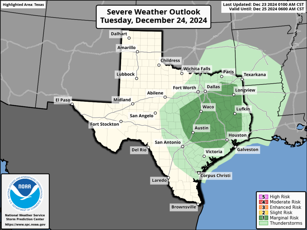
Severe weather outlook for Tuesday. (NOAA)
Tuesday
Christmas Eve will be warmish, with highs in the mid-70s and mostly cloudy skies. As moisture levels rise in the atmosphere, a disturbance will bring a healthy chance of rain. Starting in the morning, our weather could turn a little bit gnarly, with enough instability to support some thunderstorms, possibly small hail, and heavy rainfall. Most areas probably will see a few tenths of an inch of rain, but some inland locations may pick up 1 inch or more. Healthy rain chances continue during the overnight hours.
Christmas Day
The stormy weather should move off to the east overnight, although we may see some lingering fog on Christmas morning. The day itself should be nice, with partly sunny skies and high temperatures in the low- to mid-70s. Winds should be light. Lows on Christmas night will fall to around 60 degrees in Houston, with cooler conditions for areas further inland.
Thursday, Friday, and Saturday
This period will be warm for late December, with high temperatures in the upper 70s and plenty of humidity. Each day will see rain chances on the order of 30 to 50 percent, and perhaps even higher chances on Thursday and Friday nights. All in all, I expect most of Houston to pick up 1 to 2 inches of rain during this period, with higher isolated amounts. The days won’t be a total washout, but if you have post-holiday gatherings you may need to dodge some showers. If there’s a silver lining, it’s that we do need the rain.
NOAA rain accumulation forecast for now though Saturday night. (Weather Bell)
Sunday and beyond
A weak front arrives on Saturday at some point, and this should clear us out. Sunday should be sunny, and cooler, with nights in the 50s. By around New Year’s Eve, or so, a stronger front will arrive to really cool us down for the new year. It’s still too early to have details for the holiday, but the first week of 2025 should be significantly colder, including the potential for a freeze in parts of Houston. We shall see.
In brief: Houston will experience three more days of cooler weather before a warmer pattern sets in, and likely will prevail for nearly all of the remainder of 2024. We’re still anticipating mild conditions on Christmas Day, with the possibility of some showers on Christmas Eve.
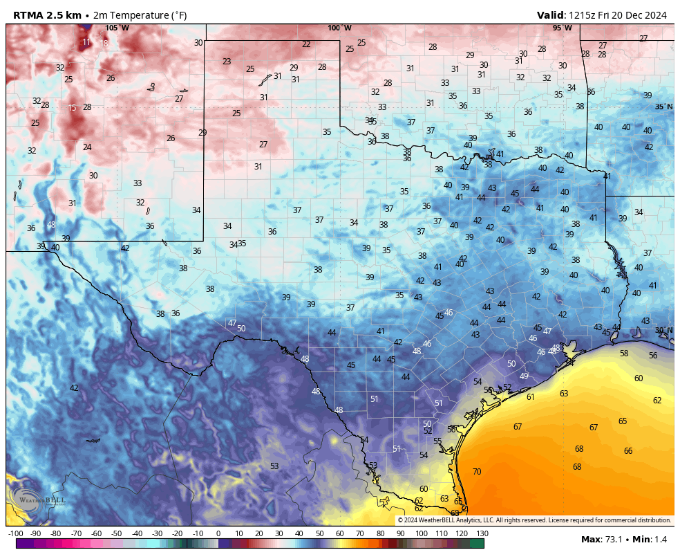
You’ve got to go all the way down to the Rio Grande Valley to find mild conditions this morning. (Weather Bell)
Baby, it’s cold outside
For a lot of people, myself included, holiday weather should feel chilly outside. Well, as you’ll see in the forecast below, Christmas Day in Houston is not going to feel like the holidays in the sense that it will not be cold. Conditions will feel rather mild, instead. However we do have some decidedly chilly weather in store for now through Sunday, so if that’s your thing, make plans for some outdoor activities, sweaters, and hot cocoa over the next few days. Speaking of holiday activities outside, a reminder that our longtime partner, Reliant, is known for lighting up the holidays and is bringing you several family fun experiences to check out!
Additionally, Galaxy Lights, presented by Reliant at Space Center Houston runs through January 5 and with Reliant’s sponsorship of Space City Weather, you can get $5 off your tickets if you use code: GLSCW24!
Friday
Temperatures have generally fallen into the upper 40s this morning, with light winds from the north. Today will be pleasant, with high temperatures reaching the upper 60s this afternoon and plenty of sunshine. We’ll see an uptick in winds this afternoon as a reinforcing cold front arrives from the north, so if you notice some gusts that’s what’s coming in. The front will bring drier air in, and this will help temperatures drop to about 40 degrees in Houston tonight. Conditions will be even colder for far inland areas, so if you’re going to be out and about on Saturday morning bring a jacket.
Saturday
A cold and sunny day. High temperatures may struggle to climb beyond the upper 50s for some locations, but with light winds and sunshine it should not feel all that cold. Saturday night will be chilly again, with lows in the lower 40s in Houston—so a bit warmer than Friday night. But not much.
Sunday
Another sunny day. However, with high pressure departing to the east we’ll start to see winds coming more from the southeast. So daytime temperatures will probably reach the upper 60s, and then Sunday night will be warmer, in the 50s. Some clouds may start to float in as well.
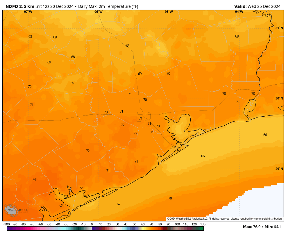
Current forecast for high temperatures on Christmas Day. (Weather Bell)
Monday, Tuesday, and Wednesday
The period leading toward Christmas Day will bring a warming trend, with highs generally in the lower 70s. With a slightly more unsettled pattern we should see some decent rain chances on Christmas Eve and the night before the holiday. However at this point Christmas Day will probably see partly sunny skies and only a low-end chance for some scattered showers. Anyway, it won’t be too hot, and it won’t be too cold.
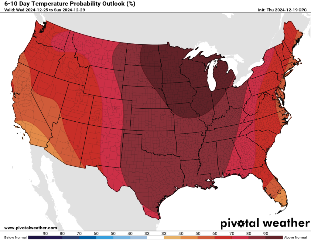
The last week of the year should be much warmer than normal. (Pivotal Weather)
Rest of next week
The final week of the year looks to be fairly warm for late December. Generally we probably can expect highs in the 70s and lows in the 50s to about 60 degrees. Some decent rain chances will be in the cards, but I don’t anticipate anything that might bring flooding or that kind of thing. Some sort of front probably will come pushing through right before the end of the year, but whether that’s New Year’s Eve or New Year’s Day or something else is hard to say.