Hi everyone. I hope everyone is enjoying this gray and windy day. We’ve seen scattered showers and a few thunderstorms through the morning and early afternoon hours, but nothing too serious.
Our main focus of concern is the development of storms this afternoon along a warm front draped just to the west of Houston. Additional daytime heating, and the approach of a cold front from the northwest, should create a line of storms that will move rapidly from west to east across the area. The National Weather Service has issued a tornado watch for the entire metro area due to the potential for some supercells to develop.
HRRR model forecast for a line of storms as of 4 pm CT on Monday. For illustration purposes only. (Weather Bell)
This line of storms should reach areas such as Katy and The Woodlands around 3 to 4 pm CT, pushing into central Houston including downtown and Sugar Land between 4 and 6 pm, and reach the coast shortly after sunset. As the front passes we’re going to see strong, and potentially damaging winds. There is the possibility for a tornado or two to develop, and also perhaps some hail.
I want to be clear: The overall conditions in the atmosphere are not super-supportive for severe weather. But the potential ingredients are there for some severe thunderstorms to come together, albeit briefly, this afternoon. Please be weather-aware if you are out and about. Some additional light to moderate rain will be possible tonight after the front passes. It will be a windy and chilly night, with temperatures quickly dropping into the 40s after midnight.
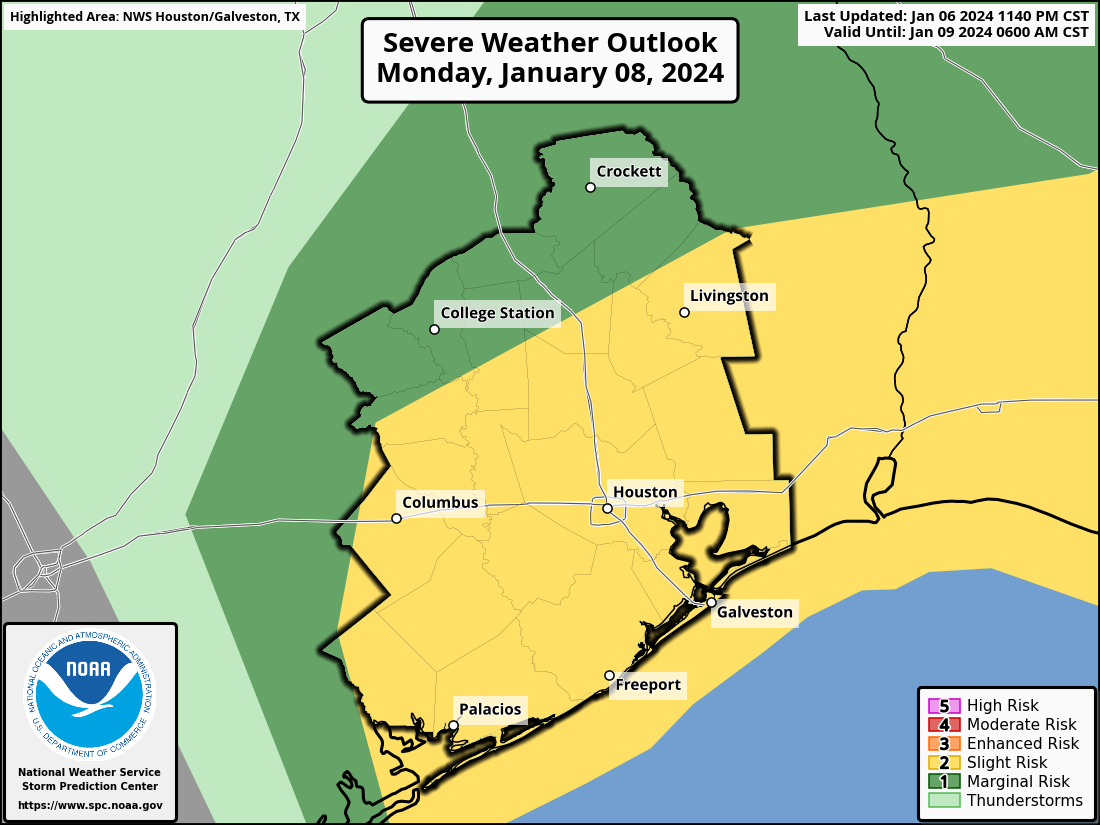
Good morning. Houston faces the possibility of storms today ahead of, and along with a cold front this afternoon. Our temperatures will plunge on Tuesday after the front, but we’ll warm up quickly and be back in the 70s by Thursday. Then another cold front arrives ahead of the weekend to drive temperatures down again. We may be looking at the region’s first freeze in more than a year by Saturday morning. We’ll see.
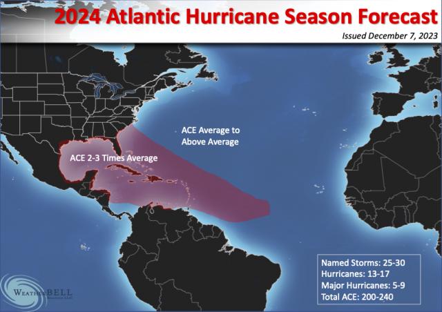
A hyperbolic hurricane outlook
Before jumping into Houston’s forecast, I want to say a few words about a seasonal hurricane forecast that has been generating a lot of attention. You may have seen it on a local TV station, social media, or elsewhere, and the gist of it is that the forthcoming Atlantic hurricane season is going to be really busy. The source of this seasonal forecast—which is clearly a case of overhyping things to get attention—is Weather Bell. The not-subtle headline on the forecast is “Hurricane Season from Hell First look.” It was actually issued a month ago (I saw it then and ignored it, FWIW), but it has been gaining traction of late.
The graphic that accompanies the seasonal forecast. (Weather Bell)
Predicting a “season from hell” is quite a statement to make in <checks notes> January. The forecast is not signed, but it reads like it was written by Joe Bastardi, the site’s chief forecaster. I like Joe, and I think he’s a talented forecaster. But he is prone to hyping things up. Case in point is the graphic showing the maximum amount of storms heading into the Gulf of Mexico, Florida, and Southeastern United States. There is just no real way to predict where the favored area of activity will be in a given hurricane season, especially six to nine months in advance. Sure, Joe could be right. But to confidently make such a prediction in January? That’s folly.
The primary basis for this seasonal forecast is that the current El Niño in the Pacific Ocean (which tends to suppress Atlantic hurricane activity) will flip to a La Niña by this summer. For our purposes this really means the months of August, September, and October, when the strongest hurricanes tend to form in the Atlantic. Such a flip is possible, but far from certain. Based on the latest modeling, there’s about a 50 percent chance of La Niña next summer during hurricane season, 40 percent chance of neutral conditions, and 10 percent El Niño. So, hardly a slam dunk.
Here’s what I would take away from all of this. Texas enjoyed an exceedingly quiet hurricane season in 2023, with no real threats to speak of. That is unlikely to be the case again this coming season, when we probably will see more activity in the Gulf of Mexico. But anyone who is selling you on a hurricane season from hell, in January of all months, is probably trying to sell you something else. Caveat emptor. I’d recommend you start paying a little more heed to seasonal forecasts in April and May.
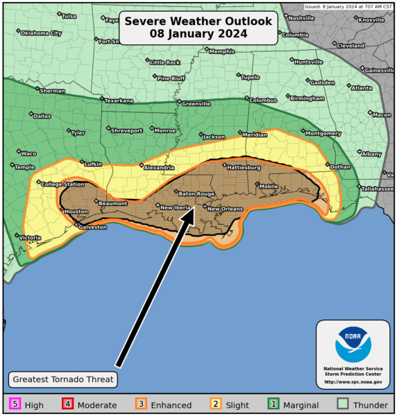
NOAA severe weather outlook for Monday. (NOAA)
Monday
Some light rain is falling across patches of the metro area this morning, and we’ll see some additional showers and a few thunderstorms later this morning and throughout the day. A line of storms will move through this afternoon, likely reaching the downtown area between 4 to 6 pm and then pushing off the coast shortly thereafter. The key question is whether these storms will become severe. We can be confident there will be strong winds, primarily from the west. Expect gusts up to 35 to 40 mph later today. Although the overall chances are low, we also can’t entirely rule out severe thunderstorms with the potential for hail and possibly a tornado. Unfortunately a lot of this mess will be setting up just ahead of the College Football National Championship Game at NRG Stadium this evening, and during the afternoon commute.
Highs today will reach into the low 70s, with a decent level of humidity, before the front pushes through this afternoon. After that we’ll turn breezy and colder, with temperatures dropping to about 40 degrees on Monday night. It’s going to be blustery outside with the strong winds overnight.
Tuesday
Expect cold and sunny weather, with highs in the low 50s. Winds will still be brisk, out of the north, gusting to 30 or even 35 mph. Lows on Tuesday night should drop into the upper 30s in Houston.
Wednesday
Warmer, as winds turn southerly. Expect highs in the upper 60s with mostly sunny skies. Lows on Wednesday night will be much warmer, dropping only into the 50s.
Thursday
Look for highs returning to the low 70s on Thursday, with partly sunny skies. There’s a slight chance of showers.
Friday
A cold front should arrive some time on Thursday night or Friday, chilling us back down again. Look for highs near 60 degrees. Lows on Friday night should drop into the 30s in Houston. Although there remains a fair amount of uncertainty, some parts of the metro area are likely to see at least a light freeze.
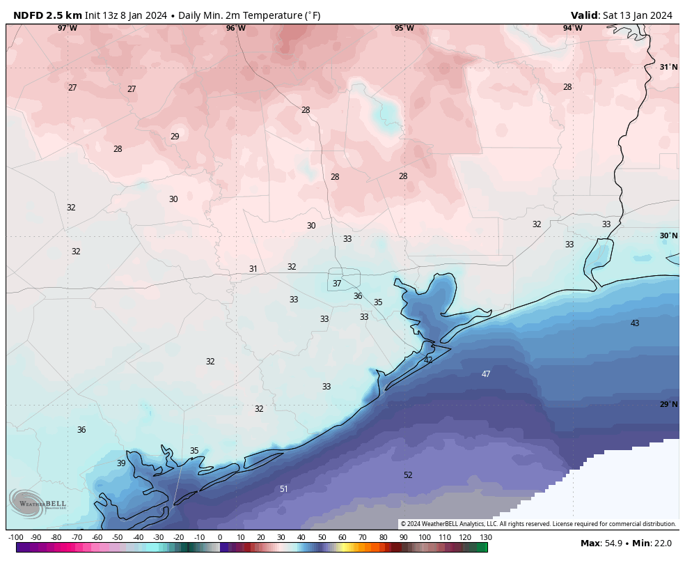
Here’s an early forecast for what temperatures may look like on Saturday morning. (Weather Bell)
Saturday, Sunday, and beyond
We can be confident that Saturday will be mostly sunny and cool, with highs likely in the upper 50s. There remains fairly low confidence for Sunday morning, the start of the Houston marathon. While we can be pretty sure there will be no precipitation, I don’t know whether temperatures will start out in the upper 30s or upper 40s. Daytime highs on Sunday are likely to reach around 60 or 65 degrees, with generally light winds. Fortunately dewpoints look to be reasonably low, so at this point I don’t expect humidity to be too much of a factor. But the models are still bouncing all over the place. Yet another front may arrive on Sunday night. Accordingly much of next week looks chilly, with highs perhaps in the 50s and lows in the 30s. Again, lots of uncertainty so we’ll see how it all plays out.
We hope everyone is having a good weekend so far. Congratulations to the Texans on a huge win last night, and we’re looking forward to next weekend’s return to the Playoffs! Today looks great, weather-wise, so whether you’re calmly watching football, taking part in the CFP Championship activities around the area, or anything else, it looks great. Tomorrow is another matter, and that’s why we’re writing a post on Sunday!
Tonight and Monday morning
Expect clouds and moisture to surge into the area tonight. By early Monday morning, we should have areas of light rain, drizzle, or spotty showers across the area. Nothing significant is expected before 10 or 11 AM, but the coverage of showers and periods of light to moderate rain should increase across the area.
Monday afternoon and evening
The good news is that the best parameters for severe weather tomorrow afternoon seem to be north and east of the area, as is often the case this time of year. The bad news is that we’re not in the clear, exactly. With clouds and showers around Monday morning, we’re likely to have a bit of a cap in place in the atmosphere, which tends to limit how severe storms can get. As showers continue Monday afternoon, they may build in intensity a bit. There are some signs that the cap may try to erode a bit, particularly east and perhaps northeast of Houston as we go into the afternoon, however, and that’s why I think we want to continue to watch tomorrow closely.
Most of the region is under a slight (level 2 of 5) risk for severe weather tomorrow. The main risks are strong winds and perhaps hail, with an isolated tornado not out of the realm of possibility (NOAA)
If a storm can get established in the area and intensify, it could produce strong winds or hail tomorrow afternoon. An isolated tornado, especially near the coast or to the east of Houston is not out of the question either. Eric will have the latest for you on this on Monday morning.
Meanwhile, a second shot of storms, coming in the form of a line of them from Central Texas will approach the area right around 5 to 7 PM, just in time for folks to head to NRG Stadium for the CFP Championship. While we don’t expect significant severe weather with this line of storms, it will be capable of producing lightning, gusty winds, or small hail as it moves through, so from a tailgating point of view, be ready to get inside.
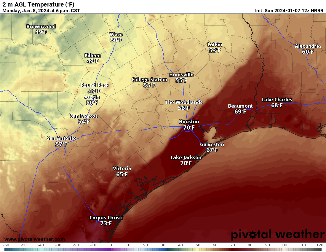
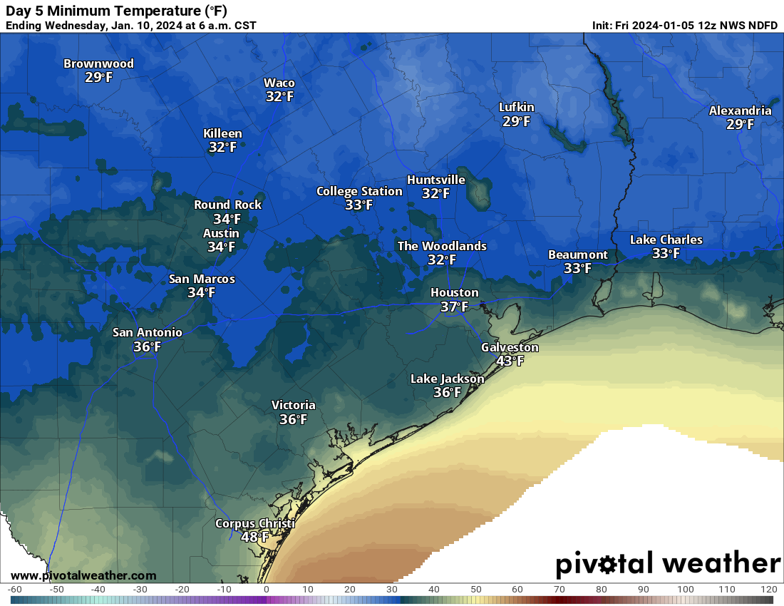
You’ll also notice a big time change in temperature as that line moves through during the evening. We will see temperatures drop from near 70 degrees before the line of storms into the mid-50s shortly after the rain kicks up.
The temperature forecast around 6 PM as the line of showers and storms comes through shows 60s and 70s before it hits but mid-50s quickly after it moves in. (Pivotal Weather)
Beyond the severe weather risk, tomorrow looks breezy. Onshore winds of 20 to 30 mph with higher gusts to around 40 mph are possible. While this probably won’t cause major issues, there is the chances that some weaker tree branches could blow down. If you’ve still got holiday decorations up, you’ll want to secure those as well. Winds will ease up a bit in the evening hours, but by the time we get to Tuesday, we’ll see more wind, this time from the other direction (the north), gusting to 35 to 40 mph and stronger over and near the coast. There will be low water levels and rough seas on Tuesday.
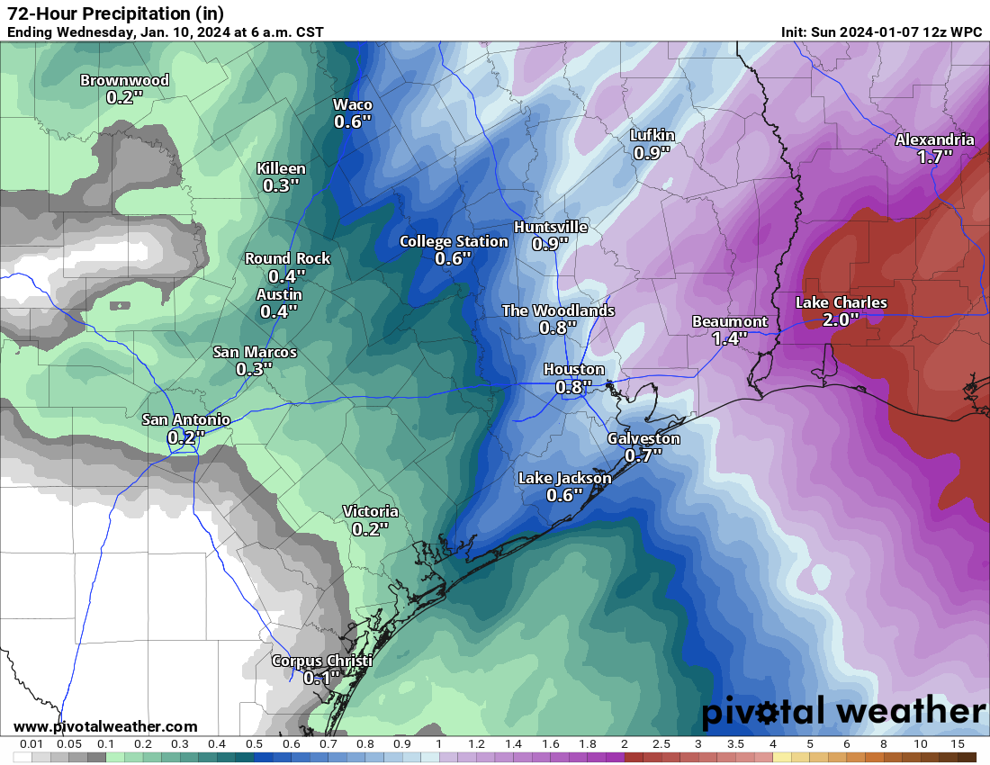
Total rainfall will probably be an inch or less for most of the area. There may be isolated higher amounts in any downpours, especially east of I-45 and in the Beaumont-Port Arthur and Lake Charles areas. (Pivotal Weather)
Total rainfall will probably average a half-inch to inch for most places in our area. Some may see a bit less (especially down toward Wharton, El Campo, or Victoria), while others may see a bit more, especially east of Houston. No major flooding concerns are expected beyond the usual localized ponding in typical trouble spots.
Expect a roller coaster ride in terms of temperatures this week, and an increasing chance of the first real widespread freeze (a typical freeze, not a massive one) of the season on Saturday morning. Eric will have the latest on all that for you tomorrow.
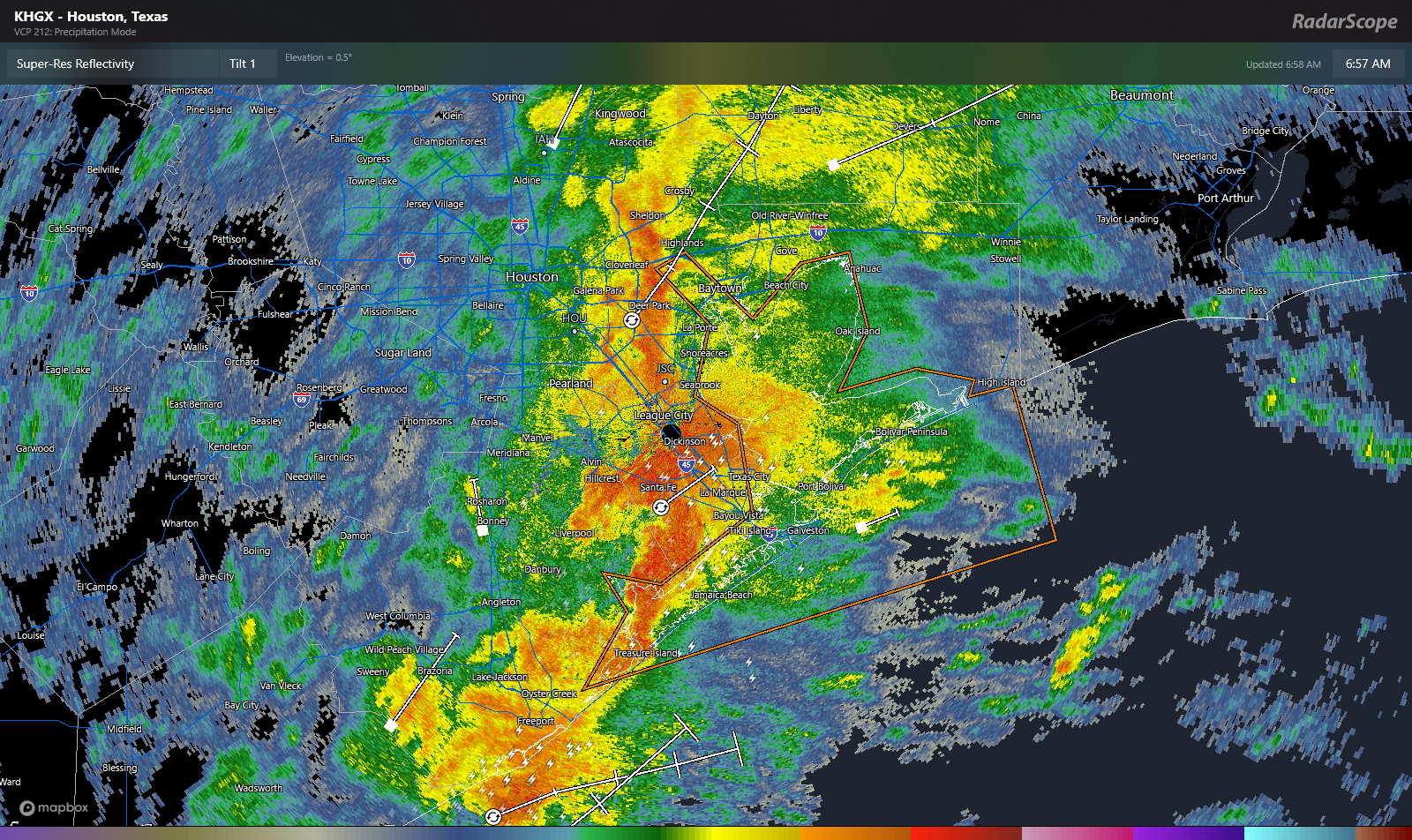
It’s been a busy morning with a line of heavy rain and thunderstorms moving through. We even had a tornado warning in Brazoria County earlier from this vigorous little storm. As of just about 7 AM, the heaviest rain is east of I-45, with Galveston and Chambers Counties in line for the worst over the next hour or so.
Very heavy rain and gusty winds will continue east across Galveston, Chambers, and eastern Harris Counties toward the Golden Triangle this morning. (RadarScope)
In addition to the rain, gusty winds of 40 to 45 mph are possible, especially in Galveston and Trinity Bays and near the coast. All of this will progress eastward toward Beaumont and Port Arthur through mid-morning with heavy rain and strong winds, as well as some embedded thunder. Most areas will finish with 1 to 1.5 inches of rain when all is said and done, with isolated higher and lower amounts.
Rest of today
Once this line of rain and storms exits to our east, we’ll be left with a few hours of showers or lighter rain and clouds this morning. By afternoon, we could see some clearing begin to push in from the west, so some sunshine may pop out, especially south and west of Houston before the end of today. Otherwise, look for highs in the 50s with a slight northwest breeze.
Weekend
This weekend looks splendid for the most part. There could be areas of fog overnight into Saturday morning, but I would expect those to clear out rather fast on Saturday morning. Otherwise, expect sunshine both Saturday and Sunday, with nothing more than the high clouds we’ve seen at times over the last month or so, especially south of Houston.
Sunday morning lows will probably be in the 30s in outlying areas, though a freeze seems unlikely (Pivotal Weather)
Both mornings should see lows near 40 or so in Houston proper and some upper-30s in the suburbs. Daytime highs will be near 60 on Saturday and probably the same on Sunday.
Monday
Next week is going to begin on an active note. From Sunday night into Monday, southerly winds will surge humidity in off the Gulf. At the same time, a storm system will kick start off the Rockies and move into the Plains, dragging arguably the strongest cold front of this winter across Texas. So what does it mean? A number of things.
First off, we’re likely to see winds pick up off the Gulf Monday, with gusts of 20 to 30 mph or even a bit stronger at times. We’ll all notice this.
It’s still too soon to really get into the finer details of things yet, but we are expecting scattered thunderstorms on Monday, and any of those storms could be on the stronger side. Right now it appears that gusty winds may be the biggest concern with any storms, but we’ll look at this closer through the weekend and report back with an update.
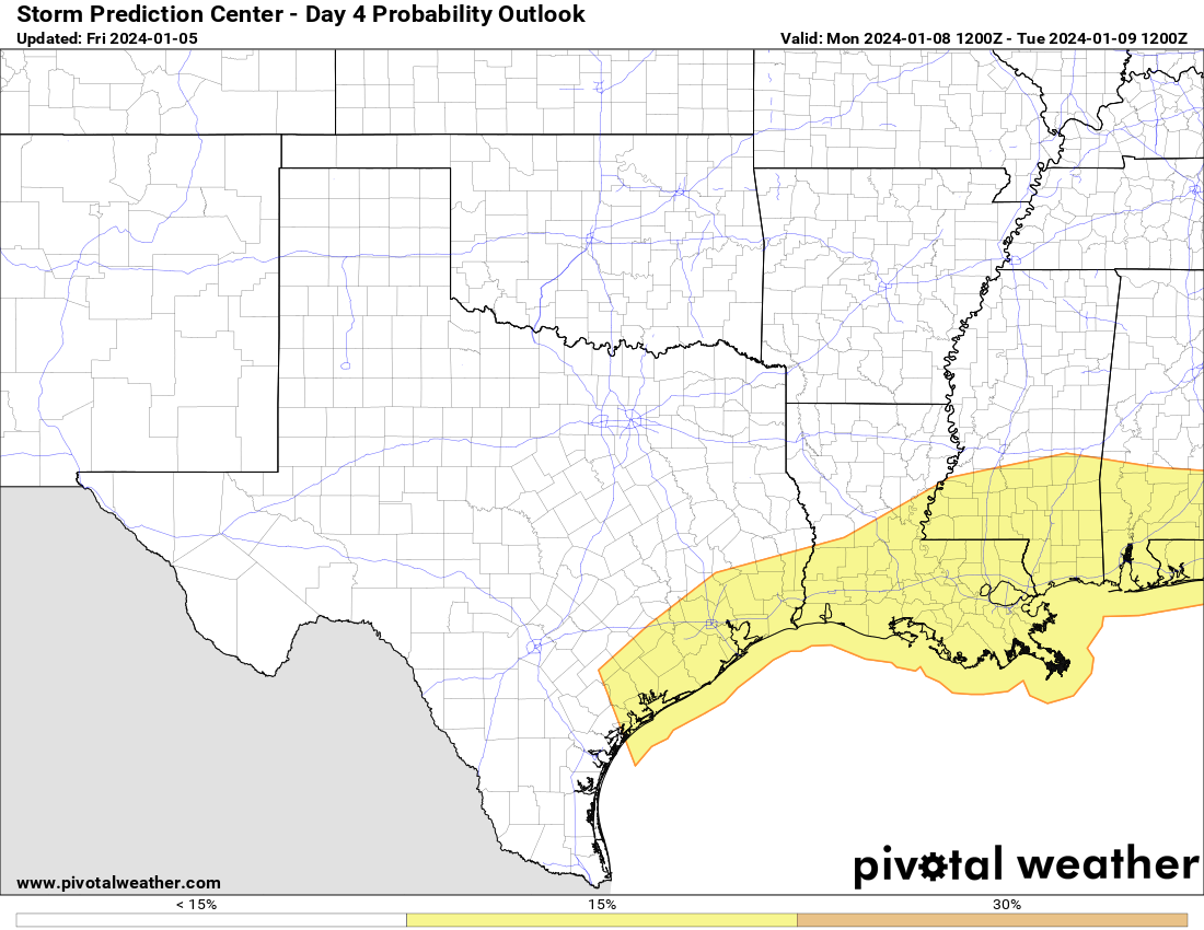
The Storm Prediction Center has the Houston area outlooked for Monday for a chance of severe weather. Not everyone will see severe storms, but a few places do have a chance for some rough weather Monday. (Pivotal Weather)
The Storm Prediction Center has us outlined for a slight (level 2 of 5) risk of severe storms right now. We’ll monitor this through the weekend.
Temperatures on Monday are also going to surge warmer, with highs likely in the 70s in the afternoon. Everyone should see a bit of rain but totals will vary widely depending on how storms setup. Again, we’ll fine tune this ahead of Monday.
For anyone heading to or visiting for the college football national championship, it’s entirely possible that you could head into NRG Stadium with temps in the 70s and leave with temps in the 40s or low-50s, so just be aware of that.
Rest of next week
On Monday evening, a cold front will sweep through the area, likely ushering in strong offshore winds and much colder weather. Wind gusts of 30 to 40 mph or even stronger will be possible Monday night and Tuesday behind the front. Much colder air will plunge in with lows in the 40s Tuesday morning and highs only in the low-50s. This might be the coldest air mass of the winter so far, and the coldest morning will be on Wednesday, with morning lows in the 30s everywhere and a light freeze possible in the suburbs.
A cold night is on tap Tuesday night into Wednesday morning with lows likely in the 30s just about everywhere and a freeze possible, if not likely in outlying areas. (Pivotal Weather)
After that, we warm back up again with temps near 60 on Wednesday and back to near 70 or so by Thursday.
Houston Marathon
Many of you are curious about the Houston Marathon. The good news is that right now the timing of systems looks good for a cooler run. The question becomes “how cool?” We should see another system bring a front into the area probably some time on Friday, leading to a cooler, breezier Saturday. As of now, I would expect race start temperatures on Sunday to be in the 40s with hopefully light winds. We would probably warm up into the upper-40s or low-50s by the end of the run. More to come!