As we’ve been telling you since Friday, the tropical system in the Gulf of Mexico—which was upgraded to Tropical Storm Harold overnight—is going to go far enough south of the Houston metro region to preclude us from seeing significant effects. We’ll see some easterly breezes, with decent gusts, and we’ll see some clouds. But unfortunately we’re not going to the kind of significant, widespread rainfall needed to help put a dent in our sharpening drought. Instead, we just get more heat.
Please don’t kill the messenger.
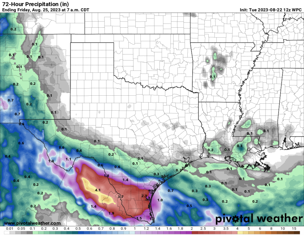
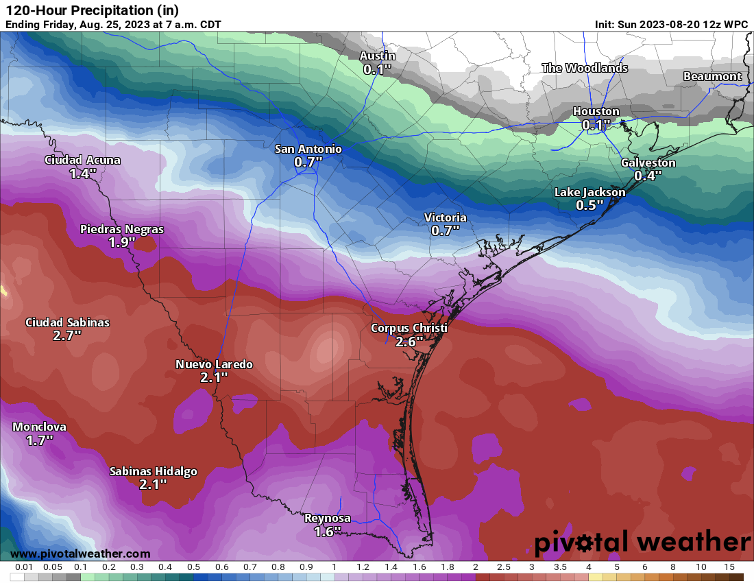
NOAA rain accumulation forecast for now through Thursday night. (Pivotal Weather)
Tuesday
Whether you see any effects from Harold will depend on how close you live to the coast. Residents of southern Brazoria and Galveston counties will have the best chances of rain, perhaps 50 percent today, and strongest winds. Gusts above 40 mph are possible today right along the coast. Areas further inland, but south of Interstate 10, will see lesser rain chances of around 30 percent, with slightly less gusty winds. Highs should be below 100 degrees for these areas relatively near the coast.
And parts of Houston north of Interstate 10? Well, it’s just going to be another very hot and mostly sunny day. Highs may reach the low- to mid-100s again for places such as The Woodlands. Rain chances for inland locations are perhaps 10 percent.
Wednesday
This will be a sunny day with highs in the low 100s across the area. With a bit of lingering moisture from Harold, rain chances are perhaps 10 or 20 percent.
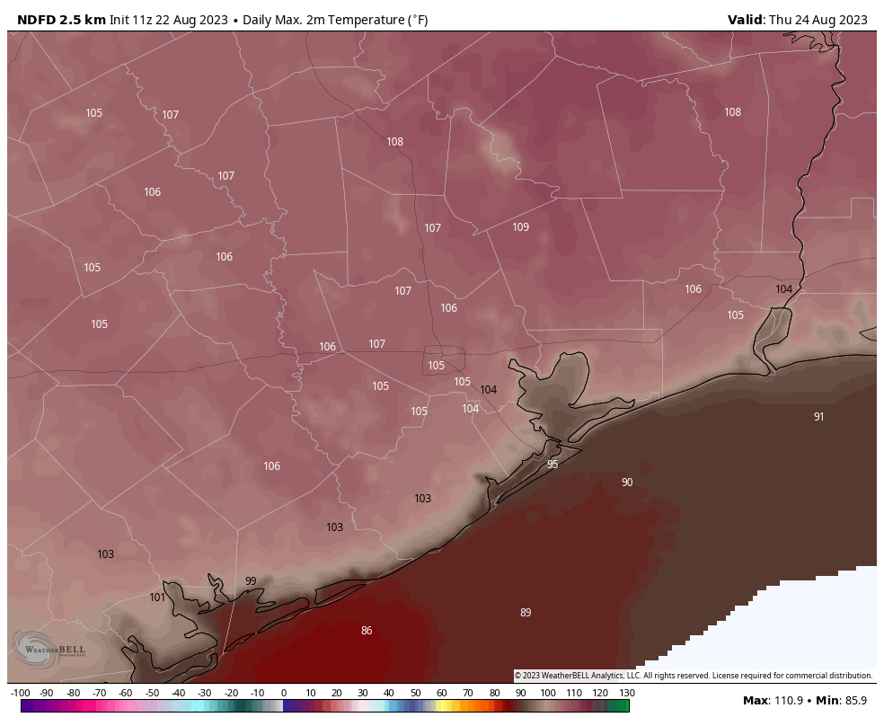
Thursday looks to be brutally hot across the region. (Weather Bell)
Thursday and Friday
These two days look really hot, with highs in the 105-degree range likely for much of the area. Skies will be mostly sunny. Rain chances are not zero, so perhaps 10 percent daily.
Saturday and Sunday
Don’t get me wrong, these will be hot and mostly sunny days. But as high pressure eases off to the West, highs may drop back down to around 100 degrees. We’ll also see some weak atmospheric disturbances that could spark some scattered showers during the afternoon hours. Please do not get too excited, as I’d peg rain chances at only about 20 percent.
Next week
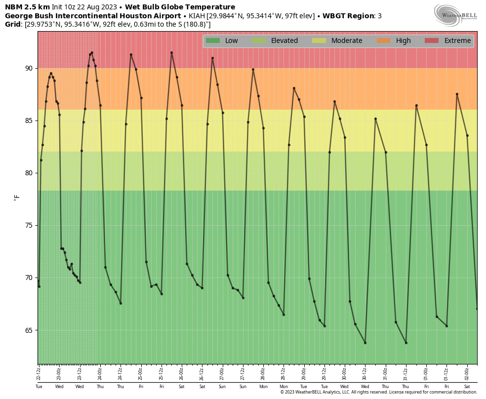
If you had hot and mostly sunny on your bingo card for next week, congratulations, you’re a winner! However, I don’t think next week will be as hot as this one, and we’re also going to see some modest rain chances. I don’t think they’ll be higher than 20 or 30 percent each day, but that is a sight better than the 0 to 5 percent we’ve experienced for much of this summer. In case you’re wondering, we’re still about three to five weeks away from when we can anticipate our first decent cold front of the season. It can’t come soon enough, I know.
Wet bulb globe temperatures show a slight moderation in the extreme heat next week. (Weather Bell)
Tropics
Beyond Harold, which will bring some tropical winds and rains to South Texas, there is a lot happening out there in the Atlantic. While there are no distinct threats to the Gulf of Mexico, or Texas, that can change fairly quickly at this time of year. Be sure and check The Eyewall for a full rundown of all the activity out there, every morning around 7 am CT. Matt has been nerding out with some book-length posts of late.
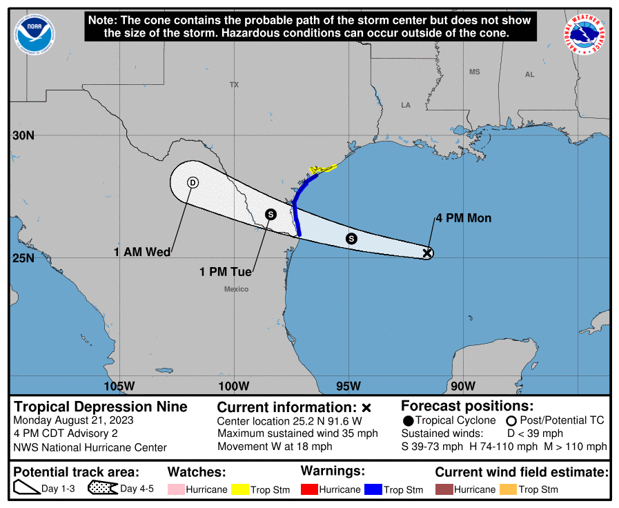
The National Hurricane Center upgraded Invest 91L in the Gulf to Potential Tropical Cyclone 9 this morning, and since its potential has been realized, it is now Tropical Depression 9. Despite these changes, which were mostly expected, not much has changed from our morning post in terms of expected impacts in Texas and Mexico. Locally in Houston, we expect to see little more than an easterly breeze, a few more clouds, and sporadic showers today and Tuesday. The action is going to be down the coast.
Tropical Depression 9 is expected to become Tropical Storm Harold tonight before making landfall in far South Texas on Tuesday morning. (NOAA NHC)
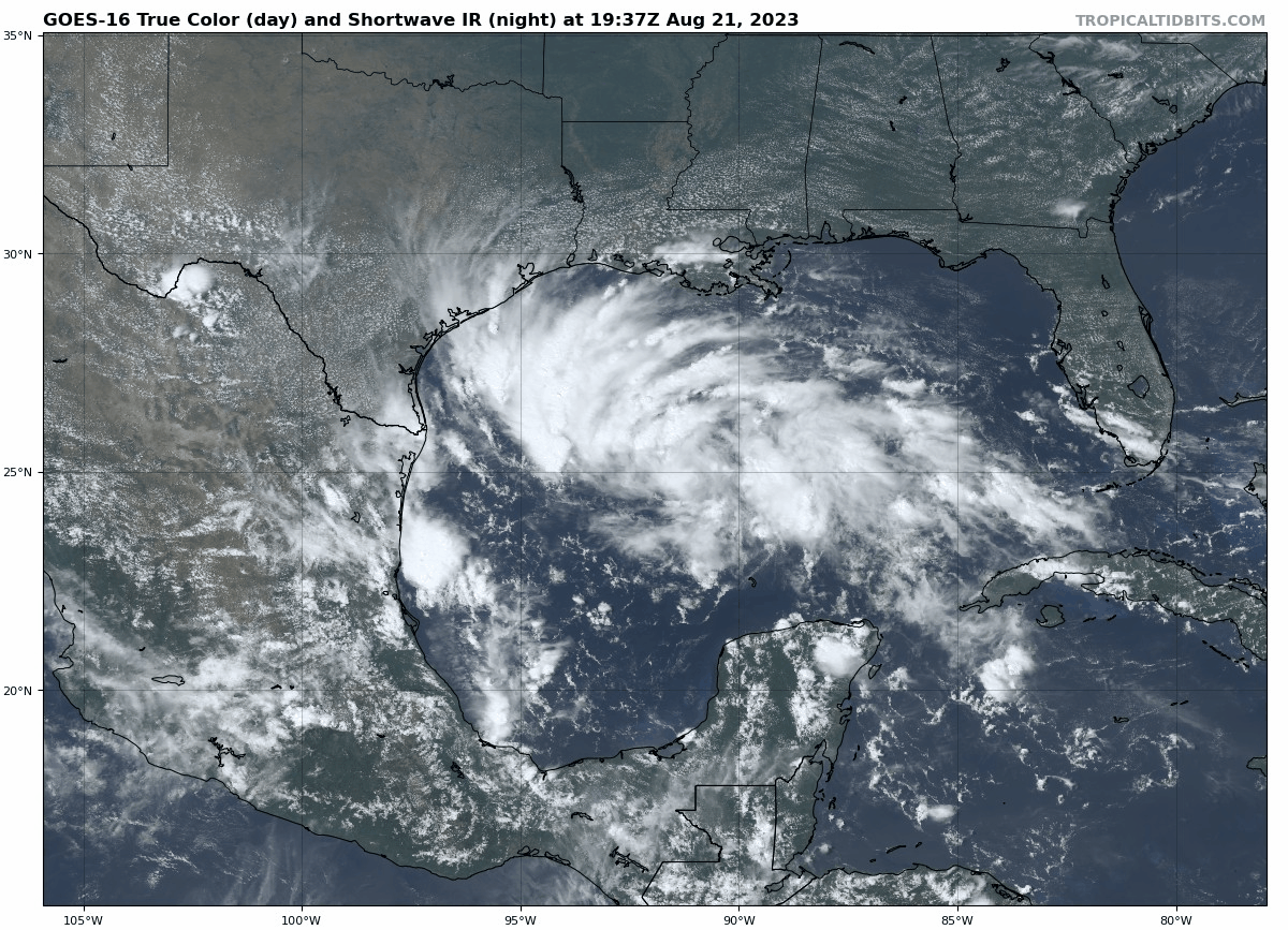
Tropical Storm Warnings are posted along the Texas coast from the Rio Grande River north past Corpus Christi to Port O’Connor. A Tropical Storm Watch extends north from there to Sargent, TX. Looking at TD 9 on satellite this afternoon shows a whole lot of storms. I said it this morning, and I’ll say it again. We are fortunate that this thing has a limited amount of time left over water.
Tropical Depression 9 is rather well defined over the Gulf this afternoon, and slow strengthening overnight seems likely before it runs out of water to feed on. (Tropical Tidbits)
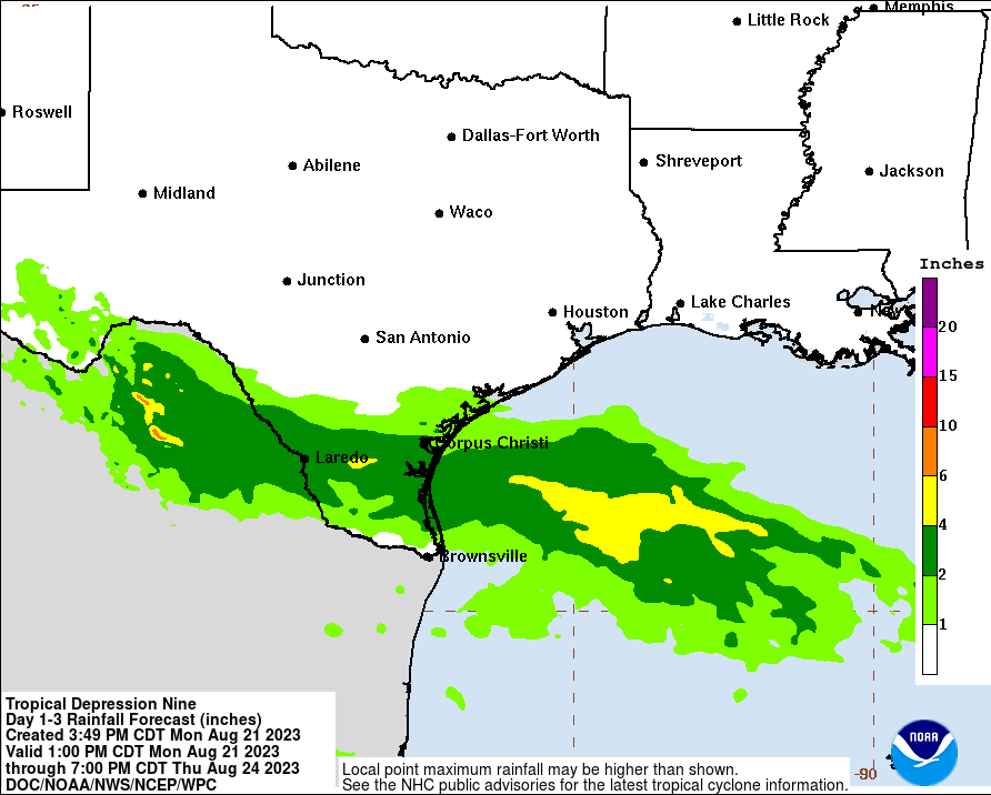
It has all the ingredients you need in place to blow up into a big storm, except the most critical thing: time. The depression is racing west at 18 miles per hour, which means it will be ashore in Texas by Tuesday morning. Impacts will be minor to moderate in South Texas, with the potential for some gusty winds to tropical storm force, mainly south of Corpus Christi and offshore. Meanwhile, beneficial rain will fall in South Texas, where generally 1 to 3 inches will fall. There will likely be a few pockets of 4 to 5 inches in Brush Country and more into the mountains of Mexico.
Rain totals of 1 to 3 inches, with pockets of 4 or 5 inches are likely in much of far south Texas into Mexico. (NOAA)
Rainfall impacts will be minimal north of there, with Houston and San Antonio mostly missing out on anything. In fact, with a bit of a breeze in between the heat ridge to our north and TD 9 to our south, we may have a slightly enhanced risk of fire danger in parts of Texas again on Tuesday. When it fails, it fails hard.
In addition to heavy rain in South Texas, there is also a chance for isolated tornadoes, as is often the case with landfalling tropical systems. But the main issue to impact your daily life in that area will be heavy rain.
By Wednesday, TD 9 or Harold will make its way across Mexico, and a piece of its remnants may actually find its way into the monsoon flow in New Mexico and Arizona, which would bring some beneficial rain to those areas that mostly missed out on Hilary’s rainfall this past weekend. Rare is the tropical system that is mostly a net positive, but this one may very well be just that. We’ll keep an eye on rain totals tomorrow to make sure things stay under control.
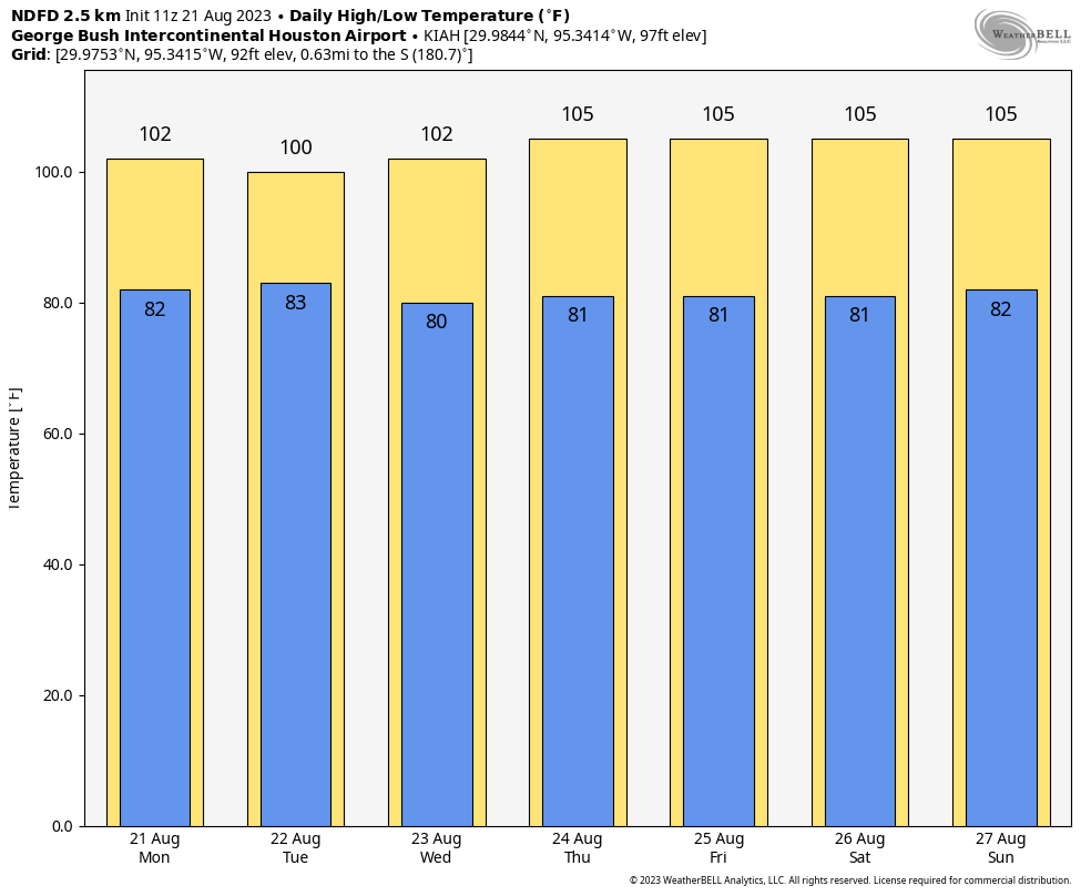
Sunday was blazing hot as upper-level high pressure continued to bake Texas. Nearly all meteorological sites across the region broke daily high records, in some cases smashing them. The city’s “official” measuring station, presently located at Bush Intercontinental Airport, reached 108°. This is one degree short of the city’ all-time hottest temperature across nearly 150 years of records, 109 degrees. This mark was recorded on August 27, 2011. Here are some other results:
Houston-IAH: 108° (1 degree short of all-time high, reached four other times)
Houston-Hobby: 107° (broke daily record high of 101°, set in 1999)
Galveston: 97° (tied record daily high from 1995)
College Station: 112° (tied all-time record high, set Sept. 4, 2000)
Sugar Land: 107° (broke daily record high of 101°, set in 2018)
Tomball: 110° (broke daily record high of 101°, set in 1999)
Our eyes now turn to the Gulf, where a tropical disturbance has a decent chance of flaring into a tropical depression or storm today, before moving into South Texas early on Tuesday. I fear we will be looking longingly at the system, because its winds and waves won’t be severe, but its rains definitely beneficial. The best accumulations will all be south of Corpus Christi, although the southern Houston area may see some stray showers today and tomorrow. See below for much more information about the Gulf disturbance.
High temperature forecast for Monday. (Weather Bell)
Monday
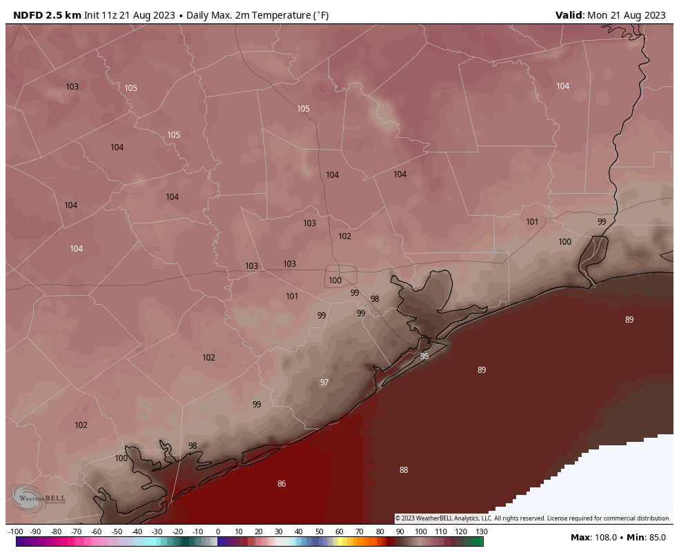
Today is going to be very hot again, although temperatures probably will be a few degrees lower than Sunday’s exceptional highs. Skies will be mostly sunny this morning, but we may see some clouds developing today. In response to the tropical system, our winds will become more easterly, perhaps gusting to 20 mph later today. These winds will exacerbate fire conditions, and a red flag warning is in effect for the combination of strong winds and high temperatures.
Will it rain today? Probably not. Some isolated areas probably will see a decent soaking, but all of the organized shower activity should be far to the south of the Greater Houston region. Rain chances are probably on the order 20 percent today and tonight for coastal Houston, and closer to 0 percent north of Interstate 10.
Tuesday
Rain chances will peak on Tuesday, at perhaps to 30 or 40 percent south of Interstate 10, and maybe 20 percent north of the freeway. This day should also be slightly cooler, with highs in the 90s for areas closer to the coast. It’s still going to be hot, though. Skies will be partly to mostly sunny.
Wednesday
A hot day, with highs in the low 100s for much of the region and mostly sunny skies. Rain chances? They’re long gone.
The period through this weekend looks extremely hot. (Weather Bell)
Thursday, Friday, Saturday, and Sunday
Unfortunately this period looks to be extremely hot, with high pressure building more directly over Texas. We’re talking highs in the low- to mid-100s, so akin to what the region experienced this past weekend. Rain chances will be on the order of about 10 percent each day.
Is there any relief at all in sight?
If you’re wondering about cool fronts and plentiful rainfall, alas, the answer is no. However at this point the ridge of high pressure does look to back off some next week, and that should take some of the top end off of the high temperatures. It should also allow rain chances to creep back up a little bit. We’ll see. This summer has been brutal, and will continue to be for some time.
All about the Gulf disturbance
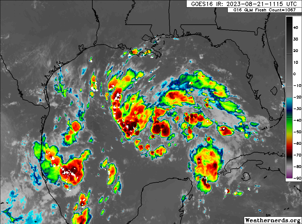
Now let’s talk about the Gulf of Mexico. This portion of today’s post comes via The Eyewall, our companion website where you can find comprehensive coverage of hurricanes. This morning, we have seen no real progress toward better organization overnight from the tropical wave, Invest 91L, in the eastern Gulf.
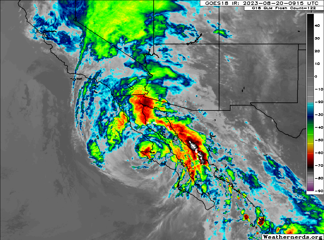
Invest 91L is not much better organized this morning, which may be a good thing given its size and the look it has on satellite. It still has a better chance than not of becoming a depression or tropical storm before reaching Texas Tuesday morning. (Weathernerds.org)
Just as a quick reminder: Invests are really just meteorological classifications given to tropical disturbances so extra data can be compiled about them; literally “an area of investigation.” There’s no strict definition, but they go from 90 to 99 and then recycle again. In the Atlantic we use “L” as an identifying abbreviation. The East Pacific is “E,” West Pacific “W,” etc.
Anyway, 91L has a broad circulation this morning but does not appear to be tightening up any as of yet. The good news is that this system only has about 24 hours left over water before it comes ashore in South Texas. The most likely outcome at this point is an approach just south of Corpus Christi or north of Brownsville.
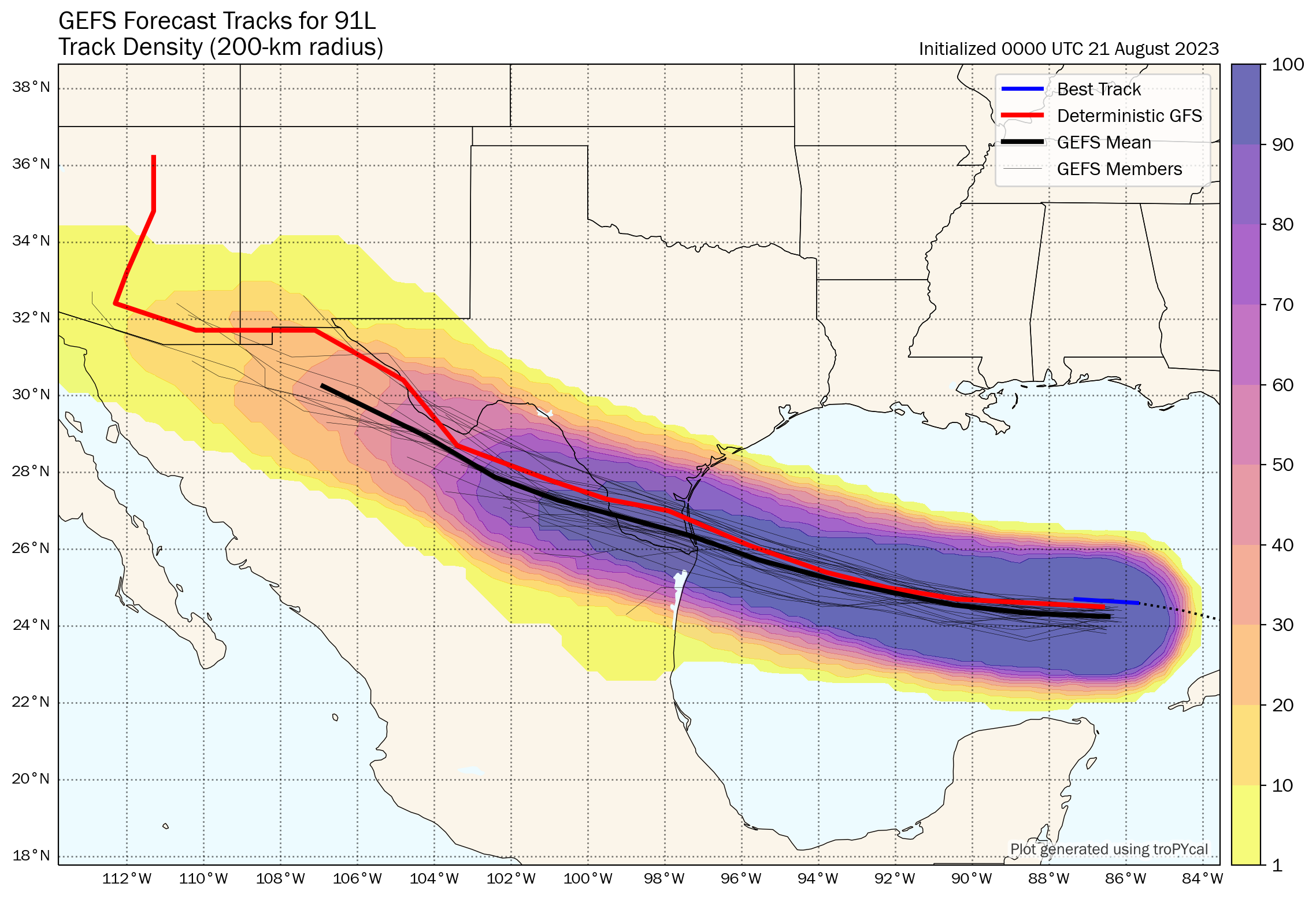
The most likely track of 91L brings it between Corpus Christi and Brownsville in South Texas, though it’s not out of the realm of possibility that it comes in south of the Rio Grande Valley in Mexico. (Tomer Burg)
Given that we have 24 hours left and given how this thing looks on satellite, my hunch is that if we see this upgraded we may skip the formalities and go right to a tropical storm. The next name on the list would be Harold. At worst, this would probably become a low-end tropical storm (45 to 55 mph maximum sustained winds, mostly in heavier rain bands and over water).
More importantly, this will be a rainmaker for Texas. The entire state desperately needs rain.
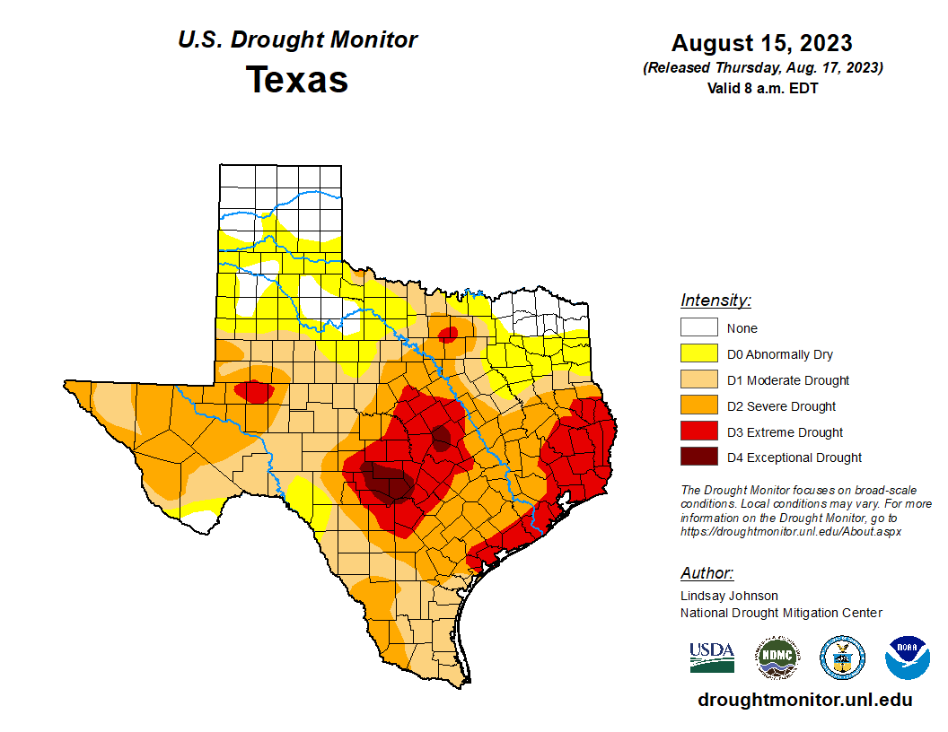
Drought is getting extreme to exceptional in much of Texas. Rainfall from a steadily moving tropical system would be mostly welcome at this point. (US Drought Monitor)
East Texas and the upper Texas coast are in extreme drought, with pockets of exceptional drought in Hill Country northwest of San Antonio. A quick moving tropical system would be virtually 100 percent positive in Texas right now. This will help. Rain totals of 1 to 3 inches with higher amounts are expected for South Texas, mainly south of Corpus Christi into the Rio Grande Valley and west toward Laredo. Northern Mexico will also receive healthy rains from this.
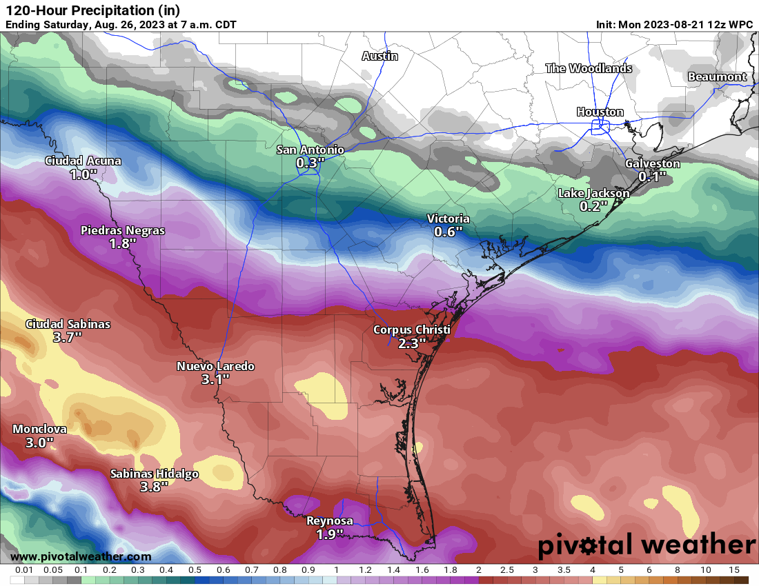
Rainfall of 1 to 3 inches on average will be expected in South Texas, with pockets of higher amounts in parts of Brush Country and in the mountains of northern Mexico. (Pivotal Weather)
While this will not end drought for South Texas, it will greatly help. Unfortunately, the hardest hit parts of the state are expecting little to no rain this week, meaning drought and fire danger will worsen.
Happy Sunday, everyone. This weekend’s tropics update is a copy of what appeared on our sister hurricane site, The Eyewall, earlier today. It provides a full information on Hilary, the Gulf system, and all of the other activity ongoing in the Atlantic basin.
In regard to Houston’s forecast in particular, as we forecast on Friday, the region will be lucky to see rains from the Gulf disturbance, as it still appears likely to track too far south to bring much precipitation here. I wish it were otherwise.
One-sentence summary
Tropical Storm Hilary is expected to impact the Desert Southwest today with extremely heavy rain and a high risk of significant flooding, while South Texas eyes beneficial rains from a tropical wave this week, one of several Atlantic disturbances right now.
Hilary: Still likely to bring severe rain & flooding to the desert
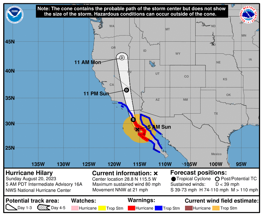
The majority of the forecast is on track, with a few noteworthy changes today, mainly in the form of higher wind forecasts in southeast California, Nevada, and southwest Arizona. Hilary is approaching the coast of Baja this morning, mostly as expected.
Hilary should make landfall somewhere in northern Baja later this morning or this afternoon. Moisture extends well out ahead of it, and tropical moisture will arrive in the Southwest today. (Weathernerds.org)
Very little has broadly changed in terms of the track, but a few nuances lead to a little more wind for the Southwest U.S. Hilary should come north as a tropical storm into California, transitioning to a depression near Death Valley, and then getting absorbed into the U.S. weather pattern over Nevada.
Hilary will maintain tropical characteristics deep into the Southwest U.S., before becoming “post-tropical” over the Great Basin. (National Hurricane Center)
Let’s walk through impacts again today.
Coastal SoCal Metros (Santa Barbara-Ventura-LA-OC-San Diego)
For most in these areas, Hilary will be a considerable inconvenience. However, there will be issues with flooding in spots. There will also be concerns about mudslides and debris flows in the foothills and near burn scars. While the majority of valley and coastal locations will see 1 to 3 inches of rain, that will be enough to cause flash flooding of roads, and travel later today may become a little difficult. Urban flooding is always a concern when you get rain rates of an inch an hour possible, which may be what occurs in spots.
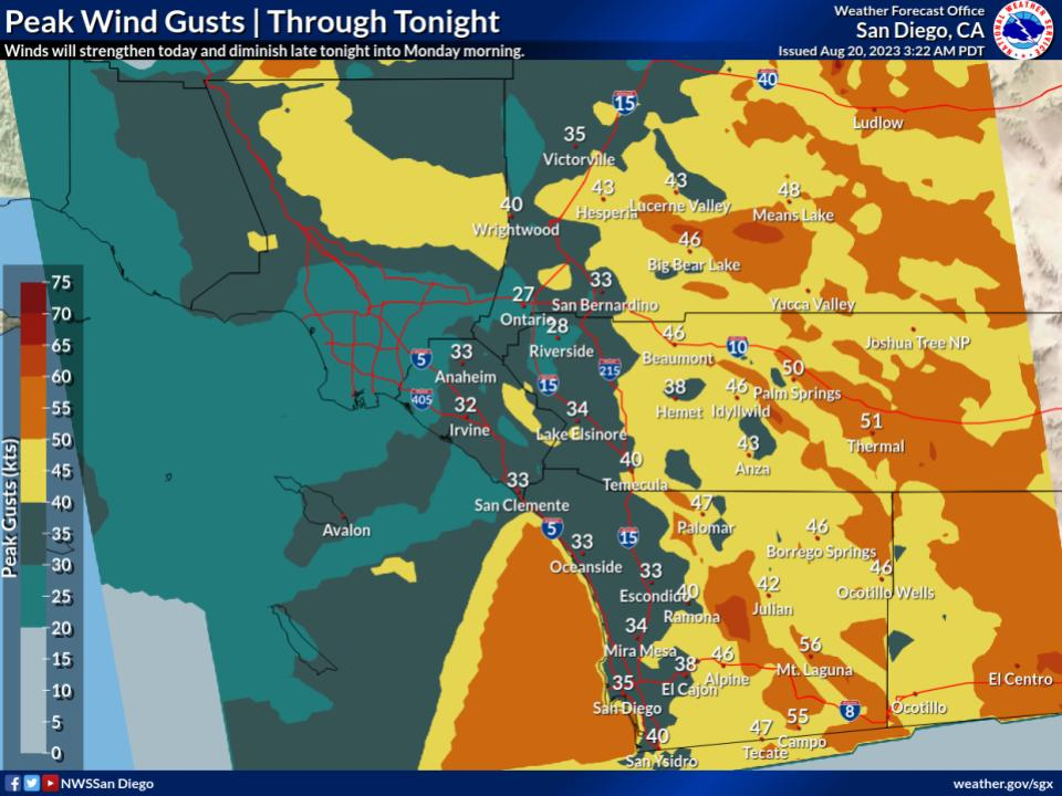
Wind gusts will peak in coastal SoCal later this morning and this afternoon into evening as Hilary comes north. Power outages are likely in spots. (NWS San Diego)
Flood watches are posted, and honestly if you don’t need to be out later today, it’s best to stay put.
While winds may not look dramatic on the map above (with 30 to 40 mph wind gusts on the coast), there will be stronger winds in spots and likely some power outages.
Conditions from Santa Barbara through San Diego will improve tomorrow.
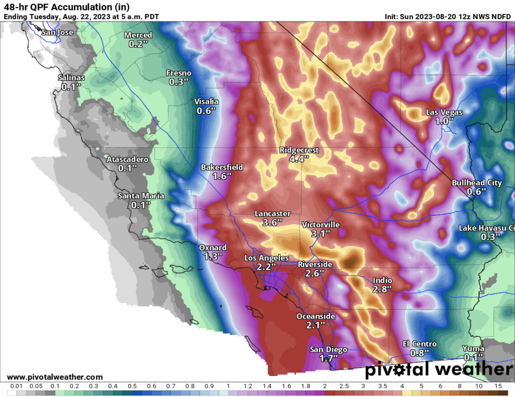
Rainfall will range from 1-3″ between Ventura County and San Diego. Higher totals are likely in the mountains and deserts and in localized spots.
Inland SoCal Metro Valleys and Mountains
The impacts inland from the coast will vary. North and east-facing mountain slopes will likely see the heaviest rainfall with 3 to 10 inches likely and higher amounts not out of the question. Rate rates will be intense, and in those particular mountains, we may see mudslides, rock slides, and the potential for significant, rapid-onset flooding. This will include the mountains east of San Diego, the north side of the San Gabriels, San Bernardinos, and Ventura County mountains. The Antelope Valley north of LA may be very susceptible to flooding due to rain in the mountains upstream.
A “high” risk of excessive rainfall and flooding is in place today for the eastern half of San Diego County into Palm Springs, the Antelope Valley, Morongo Basin (including Joshua Tree), much of the Mojave Desert, Death Valley, into Nye County, NV/the Amargosa Desert. (Pivotal Weather)
Flash flooding or debris flows will be likely in some of the foothills and mountains, and travel, particularly into the mountains or across the Antelope Valley will be discouraged later today.
Winds will mimic patterns that we usually see in these regions during Santa Ana wind events, with gusts locally up to 50, 60, or 70 mph possible. This isn’t a Santa Ana, but because the wind direction of an approaching tropical storm is similar to how winds setup in Santa Anas, you’ll get that pattern. Prepare for power outages in some of these areas.
California Deserts
As noted above, the Antelope Valley will be particularly susceptible to heavy rainfall, but the Mojave Desert as a whole will be as well. That high risk from the NWS Weather Prediction Center remains in effect today, as it has since a few days ago. Confidence is high in major, damaging flooding impacts in these areas, which may see the equivalent of a year or more worth of rain today. Areas from the Imperial Valley and Salton Sea north to Death Valley are at highest risk for poor outcomes today. Locally, mountain peaks will enhance rainfall some, including the Panamints near Death Valley. Travel is discouraged today in the deserts and between the coast and interior.
Winds will also be an issue here, with 40 to 60 mph gusts widespread and risk for higher in spots. Prepare for power outages in these areas.
Tropical storm and high wind warnings are in effect for most of Southern California, including the deserts, with gusts of 40 to 60 mph and higher likely in some of the interior areas. (Pivotal Weather)
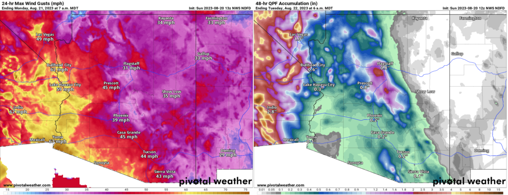
Arizona
Conditions tend to lessen some in Arizona, but there will still be issues with flooding and strong winds in the western part of the state.
Strong winds are likely in southwest Arizona, and power outages are a possibility in these spots. Rain totals (right) don’t look impressive, but there will be pockets of heavier rain and flash flooding possible, perhaps in some of the mountains north of Phoenix or in and around the Colorado River above Lake Havasu City. (Pivotal Weather)
Rain totals were dropped a good bit near Yuma today, as it appears a “dry slot,” or an area of dry air in between rainy bands may set up near Yuma.
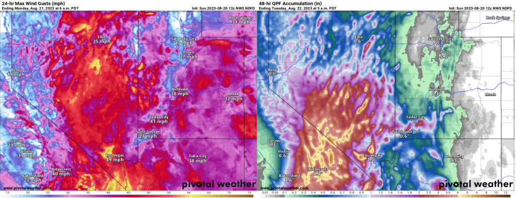
Nevada
For Las Vegas, the threat of flash flooding is real, even if the highest risks are to the west of there. Urbanized desert is especially susceptible to flooding, so if a cell or band of heavy rain just happens to set up over the Las Vegas Valley, you will have a recipe for significant urban flooding. Be aware and prepared today in Vegas.
Heavy rains will be likely in Nye County in particular from Hilary. Significant flash flooding is possible there. Strong winds will extend well north into the Great Basin as well. (Pivotal Weather)
The heaviest rain may occur near Mount Charleston. As the NWS in Las Vegas noted this morning, the Nevada 24 hour state rainfall record previously occurred there. The 7.78 inch total on Mt. Charleston may get challenged today.
In addition to the rain, strong winds will be an issue here as well and power outages are possible in southern Nevada.
Conditions should improve from south to north tomorrow.
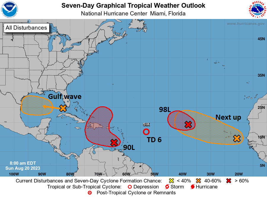
Lots of Atlantic nuisance and noise
Shifting into the Atlantic basin now. The NHC’s outlook map looks more like a leaked flag football playbook or something.
There are a lot of items on the outlook map today, but none of them look particularly serious in terms of impacts. (NOAA NHC)
Right out of the gate, let me just say that none of these systems look particularly menacing or troublesome for any areas. Busy as it may be, we’ll call this a nuisance setup. Let’s walk through these things.
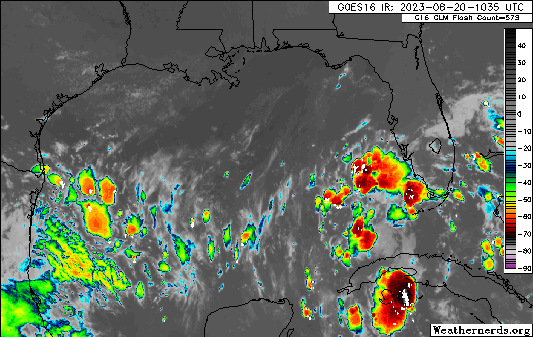
Gulf wave: A rainmaker in South Texas
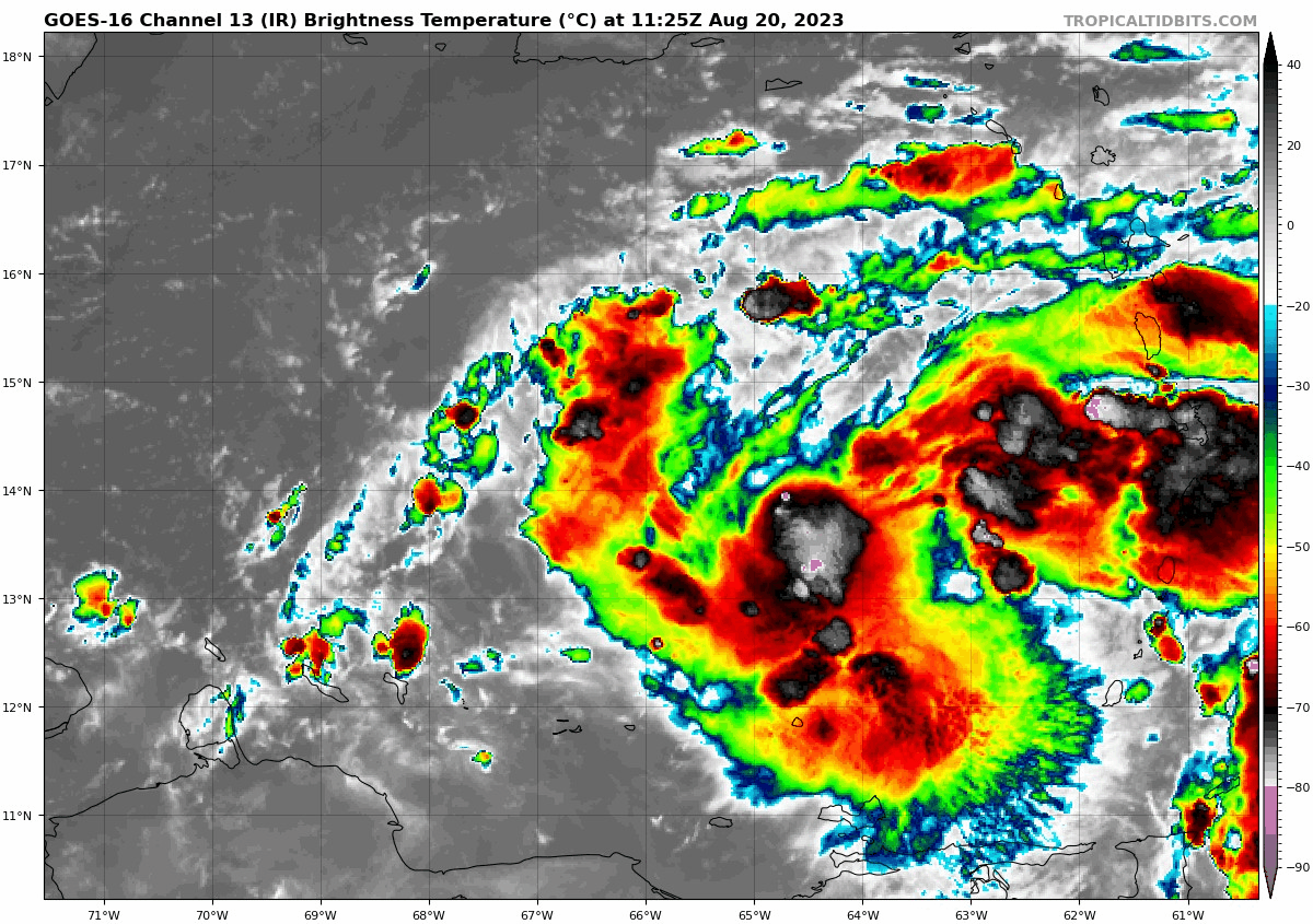
The tropical wave we’ve been talking about for several days is finally in the Gulf of Mexico this morning, and based on satellite imagery, it is not terrible looking. Organized, no, but vigorous, yes.
A tropical wave in the Gulf with a 50% chance of developing over the next couple days is robust looking but disorganized for now. (Weathernerds.org)
This will continue due west across the Gulf and make it into Texas by Tuesday morning. This has a 50/50 shot of becoming a depression or low-end tropical storm as it approaches Texas, but it is unlikely to surpass that level. The main impact from this system will be rainfall in Texas, a needed commodity. Sadly, for Houston and drought-stricken east Texas, this will do next to nothing. However, South Texas needs the rain too, and they will get some as this system moves in.
1 to 3 inches of beneficial rain is expected for South Texas, including Corpus Christi into Laredo and across northern Mexico. (Pivotal Weather)
Look for about 1 to 3 inches of rain for areas south of Matagorda Bay and lesser amounts north of there, to near 0 rain for the I-10 corridor in Houston and SE Texas.
Invest 90L: May develop today, rain for Hispaniola, Bermuda in the future?
The next wave to discuss is Invest 90L, which is located in the southeast Caribbean. It is beginning to attempt to develop there, and there’s some chance this becomes a depression or even Tropical Storm Emily today.
A robust tropical wave in the southeast Caribbean has a good chance at becoming a depression or storm in the next 24 hours. (Tropical Tidbits)
If you look at the NHC map above, you can see how 90L’s potential development takes on an “L” shape. The good news is that 90L should be drawn up north and out to sea rather quickly. The bad news is that it could impact Hispaniola, particularly with heavy rainfall. Bermuda may also want to keep an eye on 90L’s progress over the coming days. We will watch this closely for those areas this week.
Tropical Depression 6: Heads for the exits today
Invest 99L turned into TD 6 yesterday, and it will degenerate back into a wave today. Thanks for joining us.
Invest 98L & Africa waves
We expect development of Invest 98L in the next day or so, at least to a depression, maybe a tropical storm. But it will stay out at sea. Subsequent waves off Africa will likely behave similarly in the coming days.