Limited storm chances later today as drier air briefly returns to Houston

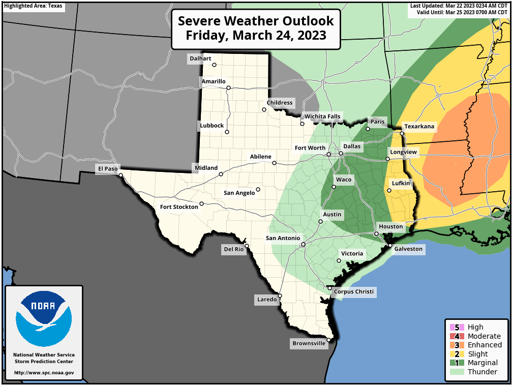
We’ve got a mixed bag of spring weather coming our way over the next two or three days, but we should be able to squeeze one pretty nice day out of everything. Top of mind will be today’s chances of thunderstorms. While there is definitely a chance of showers or some storms, we feel pretty confident that the worst of the weather today will stay comfortably north and east of our region.

The threat for severe weather today has been removed from the Houston area and is marginal (level 1/5) north of Hwy 105. (NOAA)

This morning

No serious issues are expected this morning. There will be a fair bit of low clouds and maybe some sprinkles, light rain, or drizzle around. Beyond that, nothing much.

This afternoon

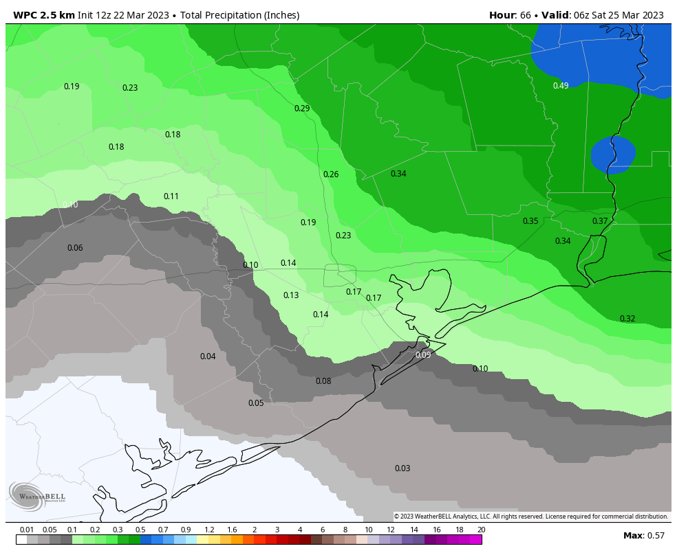
Our cold front today and tonight won’t be a classic one for us, where it pushes through with storms and we drop 10 degrees as it moves away. Rather, this will come in pieces. The first of those is this afternoon with a weak front or dryline (humidity & wind shift boundary) that pushes through. We think there will be at least a period of showers as that passes, but those may end up being primarily north of I-10. It’s entirely possible that most areas south of I-10 get absolutely nothing meaningful today.

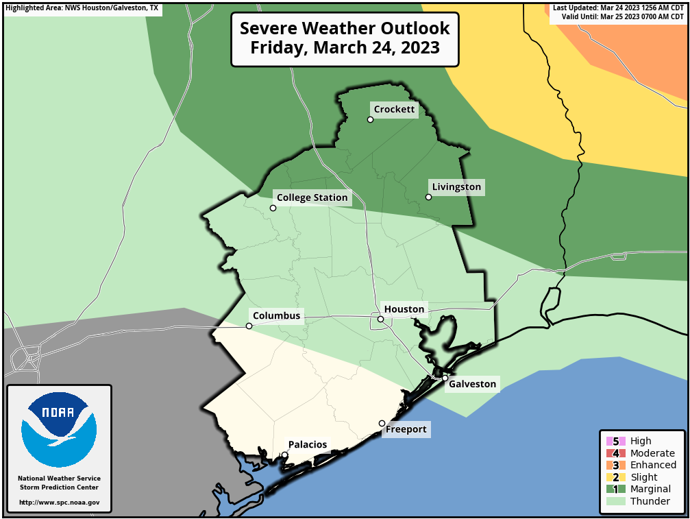
The highest chances of severe weather will be well off to our north and east, primarily into northeast Louisiana, southeast Arkansas, and northwest Mississippi. We think a pretty stout “cap” in the atmosphere will limit our chances. Again, capping just means that there’s a layer of warming temperatures as you go up in the atmosphere which tends to inhibit storm development. Most modeling shows this cap holding through the afternoon. If the cap were to somehow weaken today (very unlikely), storms could fire up pretty quick, especially to the north and east of Houston.

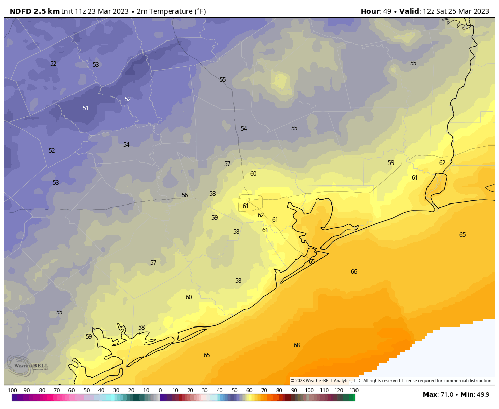
Once that boundary passes and moves to our east, skies should clear out for the evening. It may actually be a lovely evening with lower humidity and warm temperatures. We’ll top off in the 80s in most spots.

Tonight

Fog may briefly develop this evening before the final kick of drier air pushes in. Keep an eye out for that, especially along the coast, where it could linger into the overnight. Otherwise, it will be clear and comfortable with lows in the 50s to low-60s away from the coast.

Saturday

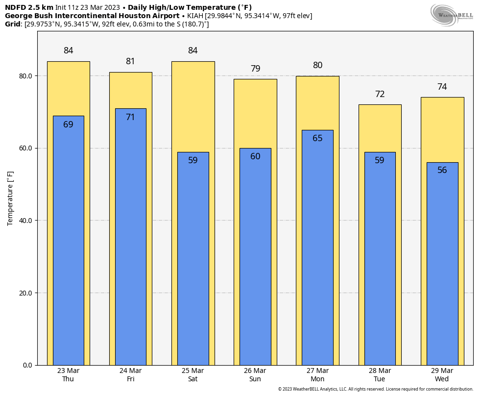
Tomorrow will be the type of day I’d look forward to in early May: Sunny and warm with low humidity most of the day. Expect highs to pop into the mid-80s, about 8 to 10 degrees above normal. Hey, break out the shorts!

Sunday

I think your chance of rain is higher on Sunday than it is most of the next few days. Here’s the deal. We have a warm front coming north from the Gulf. Dewpoints are going to surge 15 to 20 degrees higher on Sunday, which means our comfortable Saturday afternoon air mass is going to be replaced by a Gulf-infused, very humid one on Sunday afternoon. The result? Scattered to perhaps numerous showers and thunderstorms.

You don’t need to be a meteorologist to see that something is changing on the image above: These are forecast dewpoints from the NAM model between midday Saturday and midday Sunday, showing a surge in humidity off the Gulf. (Pivotal Weather)

Warm fronts are always a bit tricky because they can surprise you on the active side. I don’t want to say that Sunday will be a total washout for anyone, but we may need a follow up post on Sunday morning if it looks worse than expected right now. Prepare for some rain to interfere with your day. As a result of the clouds and higher humidity, high temperatures will peak cooler in the mid-70s after starting in the lower half of the 60s.

Next week

The weather for next week is a little tricky. We don’t really have a dominant pattern in place. We’ll probably see a weak front either late Monday or Tuesday that knocks back temperatures a few degrees. We’ll then warm back up later next week, possibly significantly so. In terms of day to day specifics, there may be a decent chance of showers on either Monday or Tuesday, followed by a couple quieter days, and then more isolated to scattered storm chances before the weekend.

Houston will see mild, Spring-like conditions through next week

Good morning. Houston’s more or less Spring-like weather will continue through this weekend and into next week. We won’t be getting too hot, and we won’t be getting too cold, and there will be a smattering of rain showers from time to time.

Thursday

Today will see fairly warm temperatures, as mostly cloudy skies give way to partly to mostly sunny skies this afternoon. This will allow temperatures to pop up into the low- to mid-80s. Winds will be noticeable out of the south at 10 to 15 mph, with gusts up to 25 mph. As clouds return this evening, expect a warm night with lows in the low 70s.

Friday

A front will progress toward the Houston metro area on Friday, likely producing fairly widespread, but mostly light showers. A capping inversion in the atmosphere will most likely prevent stronger thunderstorms from developing over the Houston metro area, but the further east you live the more likely this is to happen—further east as in the Beaumont area. Highs will be about 80 degrees on Friday, and overnight temperatures will slowly come down as the front stalls before finally pushing off the coast Saturday morning.

Saturday morning’s high temperatures will depend on how far one lives from the coast. (Weather Bell)

Saturday

This will be a fine, sunny day with an abundance of dry air. Look for sunny skies with highs in the low- to mid-80s as air temperatures warm quickly with less moisture in the air. Clouds return on Saturday evening as the onshore flow redevelops, however. Lows should drop to around 60 degrees in Houston, with cooler conditions inland.

Sunday

With a southerly flow, look for more humid and partly cloudy conditions on Sunday. Highs will probably top out in the upper 70s. It’s increasingly likely that most areas will see at least some sprinkles on Sunday, with accumulations of one to two-tenths of an inch possible.

Yeah, that is a Spring-like temperature forecast. (Weather Bell)

Next week

We’ll see more of the same next week, which is to say a weak front comes in on Monday and cools us down and dries out our air for a few days before a warmer flow resumes. The details of this remain unclear, but it seems safe to expect highs in the 70s and 80s, and lows in the 50s and 60s. So all in all, pretty Spring-like weather for Houston.

This is the ideal time of year for weddings and other outdoor events

One of the questions I’m regularly asked is for a long-term forecast for an outdoor wedding or reception in the greater Houston area. The reality is, a forecast for anything further than about 10 days out is little more than a wild guess, and planning for weddings takes months. So my advice to people considering outdoor events in Houston is to choose the time of year carefully.

A few years ago I spent some time studying this question, and the conclusion I came to is that March is the best time of year for outdoor events, in particular the second half of the month. Why? In addition to being fairly temperate, late March actually has the lowest daily chance of precipitation of any time of year. Here’s the full analysis I performed. That is not to say bad weather does not occur in March. Of course it does. But if you took this advice months ago and planned your wedding for this weekend, well, Saturday is going to be splendid. You’re welcome.

Rain accumulations for now through Friday are not overly impressive. (Weather Bell)

Wednesday

Houston has firmly returned to a warmer, and more humid pattern with a pronounced southerly flow. Lows this morning have only fallen to about 70 degrees, and with partly to mostly cloudy skies, highs will reach about 80 degrees or a few ticks higher. Again, a few sprinkles will be possible, but most of the area should remain rain free. Winds will blow from the south, gusting to 20 mph or higher this afternoon. Lows tonight will again be warm.

Thursday

Conditions will be similar on Thursday, with perhaps even more pronounced winds out of the south gusting up to 30 mph. Highs for some inland areas may reach the mid-80s.

Friday

A weak front will push through the area on Friday, likely with a thin line of showers and a few thunderstorms. At this point I think any severe weather probably will remain to the north and east of Houston, and rain accumulations here likely only be measured in one or two tenths of an inch of rain. Showers should end during the late afternoon or evening hours, with overnight lows dropping into the upper 50s.

The severe weather outlook for Friday has the best chance of storms well to the northeast of Huston. (NOAA)

Saturday

This is the pick of the litter for the weekend. Although highs will get into the low 80s, the daytime will have plenty of dry air from the front, and this will also clear our skies out for the day. The onshore flow resumes pretty quickly on Saturday afternoon or evening, however, and therefore lows on Saturday night probably will only drop into the low 60s.

Sunday and beyond

Sunday and part of Monday look warmish, with highs in the low 80s and humidity, before another front arrives on Monday. Both days also have a 40-ish percent chance of light rain. It’s too early for firm details, but I think we’ll see a few days in the 70s, with lows in the 50s next week in the wake of the front. That should feel pretty pleasantly spring-like for the region I’d say.

Is that it for cold air during the Winter of 2022-2023?

Houston’s first nighttime temperature below 50 degrees this winter occurred back on October 19, about five months ago. With Houston now getting deeper into Spring—and June just 72 days away—it is natural to wonder whether this most recent cold spell was the region’s last of the winter.

The short answer, I would say, is no. While we are definitely entering a pattern where warmer rather than colder weather is the norm, we should still see some decently cold weather during the next six weeks. In fact, I think there’s a modest chance that parts of the Houston metro area see sub-50 degree temperatures about eight to 10 days from now.

Tuesday

But not today. The onshore flow is fully in control of our weather this morning, and we’re going to see a gradual rise in humidity until a front on Friday. High temperatures today will be on the order of the low 70s, with mostly cloudy skies. Winds will be out of the south, gusting to 25 mph at times. And low temperatures tonight will not drop far, perhaps only into the upper 60s. A few areas may see some sprinkles later today as a weak disturbance moves through.

Wednesday

Warmer still, with a high temperature of around 80 degrees and continued partly to mostly cloudy skies. Winds will again be gusty of out the south.

Thursday will be fairly warm in Houston. (Weather Bell)

Thursday

This probably will be the warmest day of the week, with highs in the low- to mid-80s. Nights will continue to humid and mild.

Friday

I expect fairly widespread showers on Friday, but accumulations look fairly slight, on the order of one-quarter to one-half an inch of rain for most. At this point I can’t entirely rule out some stronger thunderstorms with the front, but as of now I don’t think there will be too many fireworks with its passage. These showers should end by the afternoon, or early evening hours as a moderate front moves in with some drier air. Highs on Friday will be about 80 degrees ahead of the front, dropping into the 50s overnight.

They won’t last long, but lows on Saturday morning will have a decent chill to them. (Weather Bell)

Saturday

This will be a fine springtime day with sunny skies and high temperatures in the low 80s. The reason we’re going to get so warm right after the frontal passage is that we’re going to see some fairly dry air moving in for a brief period on Saturday. But these winds will turn southerly again pretty quickly on Saturday afternoon or so, and therefore I expect lows on Saturday night to only drop to around 60 degrees.

Sunday

Highs on Sunday will again be in the low 80s, but with more humidity and probably more clouds.

Next week

Monday looks warm as well before another decent front moves in to bring us some days in the 70s, probably. Rain chances look fairly low, and temperatures fairly moderate, for much of next week.