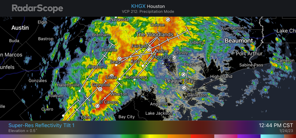
Good afternoon. As of about 12:45 pm CT, the main line of severe weather associated with a cold front is draped across the region from El Campo to Sealy to The Woodlands, and it is steadily progressing eastward. As expected, this system is bringing wind gusts above 40 mph, heavy rainfall, and at least one confirmed tornado and multiple other warnings. We are starting to see some street flooding in areas west of Houston, and I expect this to persist for the next few hours as rainfall rates reach 1 to 2 inches per hour. This heavy rainfall will spread into central and southeastern Houston over the next couple of hours.
Houston radar reflectivity at 12:44pm CT on Tuesday. (RadarScope)
The main line of storms should reach areas such as Sugar Land, downtown Houston, and Bush Intercontinental Airport by around 1 to 1:30 pm, and push down closer to the coast, through areas such as Pearland, Clear Lake and Baytown by around 3 pm. The system should be fully offshore, with clearing skies area-wide, by 4:30 to 5 pm. Some low-lying street flooding may persist through the evening rush hour due to the heavy rainfall, however.
I realize that the timing of these storms is extremely inconvenient for schools and day cares and other institutions that let out during afternoon hours. I cannot say much to that effect, but if your school is located inland of Interstate 69/Highway 59, conditions should be clearing out by around 3 pm, and if you live on the coastal side of this highway, this probably will be about the time you see the worst conditions.
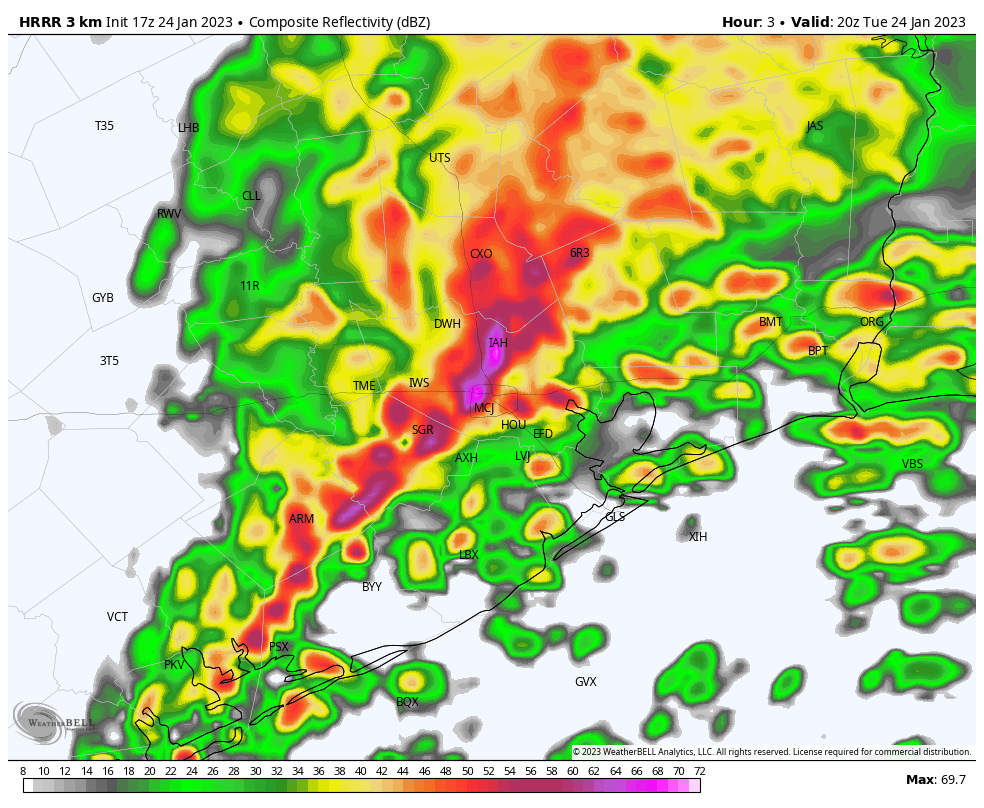
HRRR model forecast for radar reflectivity at 2 pm CT on Tuesday. (Weather Bell)
So far this event is proceeding just about as we expected, with nasty winds, rains, and the threat of tornadoes. I expect the latter threat to peak from about 1 to 3 pm and then gradually diminish, with the rains following suit. Heavy winds will be with us throughout the night, shifting from the west to northwest overnight. If you can stay off the roads this afternoon, you should. If you have to venture out, have a radar map handy, and a way to receive emergency alerts.
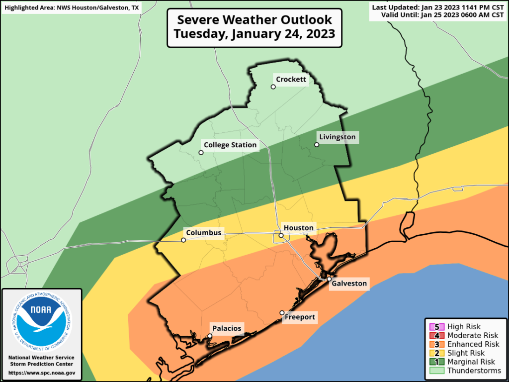
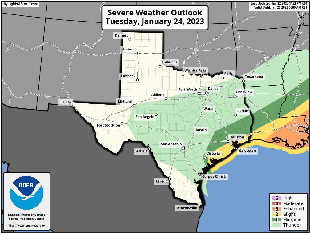
Some cold fronts come into Houston like lambs. Today’s front, however, will be a lion. The prime time for severe weather today will run from late morning to about 4 pm as the front barrels into the region. A lot of the ingredients that we look for when it comes to severe weather, including instability and an energetic atmosphere, will be in place ahead of, and along with the front today. We’ll discuss the threats in greater detail below.
In the big picture, a strong upper-level system will track toward Texas, inducing a low pressure system at the surface that will create turbulent conditions. Ahead of this low, we will see strong southerly winds this morning, gusting up to 40 mph. These winds will shift to come from the west and then northwest as the front passes. Scattered showers and thunderstorms will be possible this morning ahead of the front, but the main line of storms will likely bring the most severe weather. In terms of timing, I expect the front to reach a line from Katy to Tomball to Conroe by 1 to 3 pm, push into the central Houston corridor from Sugar Land to downtown to Kingwood from 2 to 4 pm, and push off the coast from 4 to 6 pm. Let’s consider the three main threats.
Severe weather outlook for Tuesday. (NOAA)
Damaging winds: In response to the low pressure system, expect sustained winds of 30 mph or higher, with gusts of 40 to 50 mph across much of the area, especially south of Interstate 10. These winds may be strong enough to cause isolated power outages. Any outdoor furniture prone to blowing around should be put away, if possible. These kinds of winds will knock down tree limbs as well.
Heavy rain: Expect 1 to 3 inches of rain for most areas, with isolated totals of 4 inches or higher possible in areas that see storms this morning ahead of the front. The bad news is that, with the main line of storms, rainfall rates up to 2 inches per hour are possible. The good news is that the system will move fairly quickly from west to east, clearing the area. Some street flooding is possible, but I’m hopeful that roads will be clearing in terms of water by rush hour in the metro area.
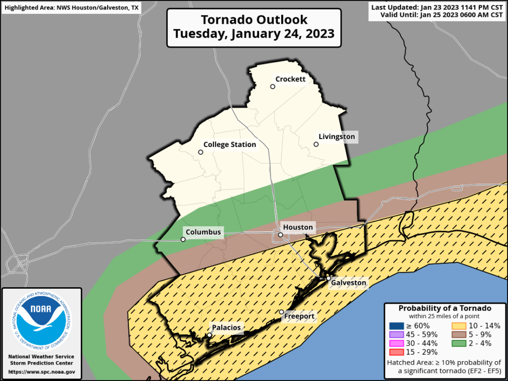
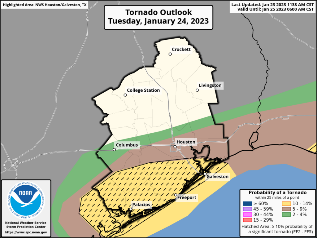
Tornadoes: There is plenty of instability, lift, and shear in the atmosphere today. A lot of the parameters that we look to for tornadic activity are lighting up, especially for areas along and south of Interstate 10. But with that said, the overall environment is not ideal for tornado formation such as one might see in Oklahoma later in the spring—just supportive. The most likely time for this activity is from noon to 4 pm today, so please be weather aware at that time. Your overall odds of being impacted by a tornado are quite low, but these are high-consequence phenomena worth paying attention to.
Areas in yellow are at highest risk for a tornado on Tuesday afternoon. (NOAA)
Be weather aware: Space City Weather will provide additional updates today as warranted. We also will be providing notifications through our app (Apple version, Android version) of any significant tornadoes that form. Other good resources include NOAA weather radio and emergency alerts from the National Weather Service.
Tuesday
As noted above, today will be a windy, rainy, and nasty day. High temperatures ahead of the front will reach the upper 60s beneath mostly cloudy skies. After the front, winds will quickly shift to come from the west, and then the northwest, bringing much cooler and drier air into the region. Temperatures tonight will drop to about 40 degrees in Houston, with colder conditions further inland. With brisk, gusty winds, it will “feel” like freezing temperatures outside late tonight with the wind chill.
Wednesday
This will be a breezy and cold day, with sunny skies and highs in the mid-50s. Winds will still be gusty, up to 25 mph out of the north. Lows on Wednesday night will drop into the upper 30s.
Thursday
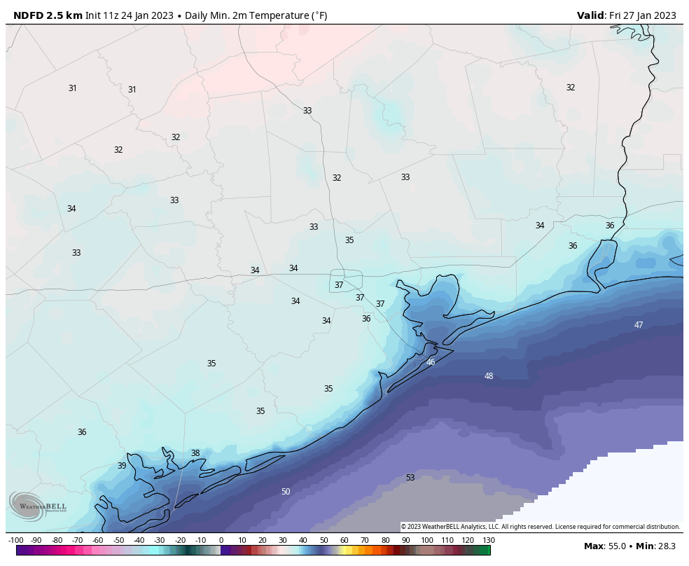
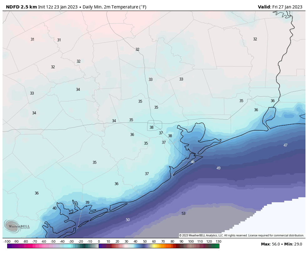
Winds will finally start to slacken some on Thursday, at just 5 to 10 mph, and we can expect to see highs in the mid-50s. With lighter winds, Thursday night should be the coldest of the week, with lows possibly dropping to freezing for far inland areas.
Low temperature forecast for Thursday night. (Weather Bell)
Friday
Look for mostly sunny weather, with highs around 60 degrees. As the southerly flow reestablishes itself, lows will only drop to around 50 degrees on Friday night.
Saturday and Sunday
I’m afraid the weekend outlook is not great. Both days have solid rain chances, but the most likely time is probably from Saturday evening through Sunday, with accumulations of perhaps 0.5 to 1.5 inches of rainfall. Highs will be near 70 degrees by Sunday before some sort of front cools us down a little bit.
Our next update will be posted no later than 1:30 pm CT.
Hi all. We’re jumping in here with a quick update on the storm system associated with a cold front that will move through Houston on Tuesday afternoon. Put simply, we are more concerned about the potential for tornadoes to develop ahead of, and along with a line of showers and thunderstorms at that time.
This morning, if you recall, we said we would assess whether a Stage 1 flood alert is warranted for Tuesday’s storms. After a discussion, Matt and I don’t think that is necessary. Most of the region will likely see 1 to 3 inches of rainfall, which is manageable for area roadways, even if it comes down in some heavy bursts. Some areas may see higher totals, and low-lying areas may briefly flood. But these storms should sweep through the area during the afternoon and then be gone. Showers and thunderstorms will be possible ahead of the main line of storms. However, we expect the main event to come with the line itself, which should reach west (Katy) and northwest areas (Tomball) around 2 to 4 pm, downtown an hour later, and push off the coast by around sunset.
Tornado outlook for Tuesday. (NOAA)
Our post this morning also mentioned strong wind gusts, particularly along and south of Interstate 10. This forecast remains the same. Areas such as Brazoria and Galveston counties may see gusts up to 50 mph. What has changed is the tornado threat. High resolutions models indicate conditions may become favorable for rotation, which increases the likelihood that tornadoes may form. This threat is reflected in an update from the NOAA Storm Prediction Center this afternoon, which highlights an area of greatest risk south of Houston (yellow area in the map above). I know the mention of “tornadoes” freaks some people out, but it is important to remember that twisters in our region are usually short-lived, and have fairly narrow tracks. Your odds of being directly impacted are rather low, even during an event such as we will see tomorrow.
The worst of this should be over for most of the metro area by the evening rush hour on Tuesday, but that will be something to monitor. The bottom line is this: Tomorrow is a day to be weather aware in the Houston community, especially from around noon to sunset. After that time skies will be clearing, and sharply colder air moving in from the north. Then we’ll get a few days of very solid winter-like weather.
Our next update will be posted by 7 am CT on Tuesday.
There is no way to spin Saturday’s lousy weather in Houston, which was just a dreary day. But the second half of the weekend made up for it with some spectacularly sunny weather. If you caught sunset on Sunday night and did not go inside right away, then you were able to enjoy an additional celestial treat. The setting Sun was followed by a lovely, very thin crescent Moon on Sunday evening. A little higher in the sky, there was the bright light of Venus. Just to the right of Venus there was a considerably fainter “star.” This was, in reality, Saturn.
Looking ahead to this week, our immediate concern is the potential for severe weather on Tuesday, particularly near the coast, with the passage of the next cold front. After that we’ll see sunny skies and sharply colder nights through the rest of the work week, with a warm-up by the weekend.
Monday
Today should be pretty nice, with mostly sunny skies and high temperatures near 60 degrees. Winds will be light, out of the northeast, at 5 to 10 mph. However, later today and tonight, winds will start to shift to come from the east, and turn more gusty. This increased atmospheric moisture will support the development of clouds tonight, and should hold overnight lows at about 50 degrees.
Tuesday
An upper-level disturbance will approach our region on Tuesday and really stir up the atmosphere. As this low pressure system nears to Houston region it may be intensifying, leading to a line of strong showers and thunderstorms as it sweeps through the region during the afternoon hours.
Severe weather outlook for Tuesday and Tuesday night. (NOAA)
Starting out during the morning hours, we’ll see scattered showers and thunderstorms. Winds will shift from the east, to south, to finally come from the west as the front approaches and then passes through the Houston area. I think the line of storms will probably reach areas such as Katy between about 1 to 3 pm, the downtown area about 2 to 4 pm, and push off the coast by 4 to 6 pm. These storms are going to bring three things: Strong winds, especially near the coast, where gusts will reach 40 to even 50 mph; briefly intense, heavy rainfall; and the potential for some isolated hail and perhaps a tornado or two. As the low pressure system will likely be intensifying as it moves into Houston, the strongest and most severe weather appears likely to develop south of Interstate 10, in areas such as Brazoria and Galveston counties.
We are closely monitoring the potential for street flooding, as these storms will likely produce widespread accumulations of 1 to 3 inches of rainfall, with higher isolated totals. We are not quite ready to issue a Stage 1 flood alert, but it’s something we may do later this afternoon as we see more data. The bottom line is that conditions in Houston on Tuesday afternoon may briefly turn fairly nasty. Winds become northerly on Tuesday after the front’s passage, dropping lows to around 40 degrees in Houston.
Wednesday and Thursday
These will be cold winter days (for Houston). Look for mostly sunny skies, breezy northerly winds, and highs in the mid-50s. Both nights will drop into the upper 30s in Houston, with colder conditions further inland. We cannot entirely rule out a freeze for some far inland areas.
The low-temperature forecast for Thursday night looks chilly. (Weather Bell)
Friday
Highs should climb to around 60 degrees on Friday, so a bit warmer, with mostly sunny skies. Lows Friday night will only drop into the mid- to upper-40s as a more southerly flow returns.
Saturday and Sunday
The forecast for the weekend is a little bit blurry, but I do think we’ll see a healthy chance of showers, although it’s difficult to pinpoint when, or how much rain. Chances, for now, look best south of Interstate 10. Temperature wise, I think we’ll be back to highs of around 70 degrees, with lows just in the 60s. Hopefully we’ll get some more clarity on the weekend forecast in a day or two.
Next week
The broad trend supports a cooler pattern again for next week, but the details are understandably lacking. There is perhaps a 1-in-4 chance of seeing some substantially colder weather later next week, with lows near freezing, but my guess is that we’ll probably see something milder than that. I only mention this because some readers have been asking whether winter is over yet. My short answer is: “I don’t think so.”