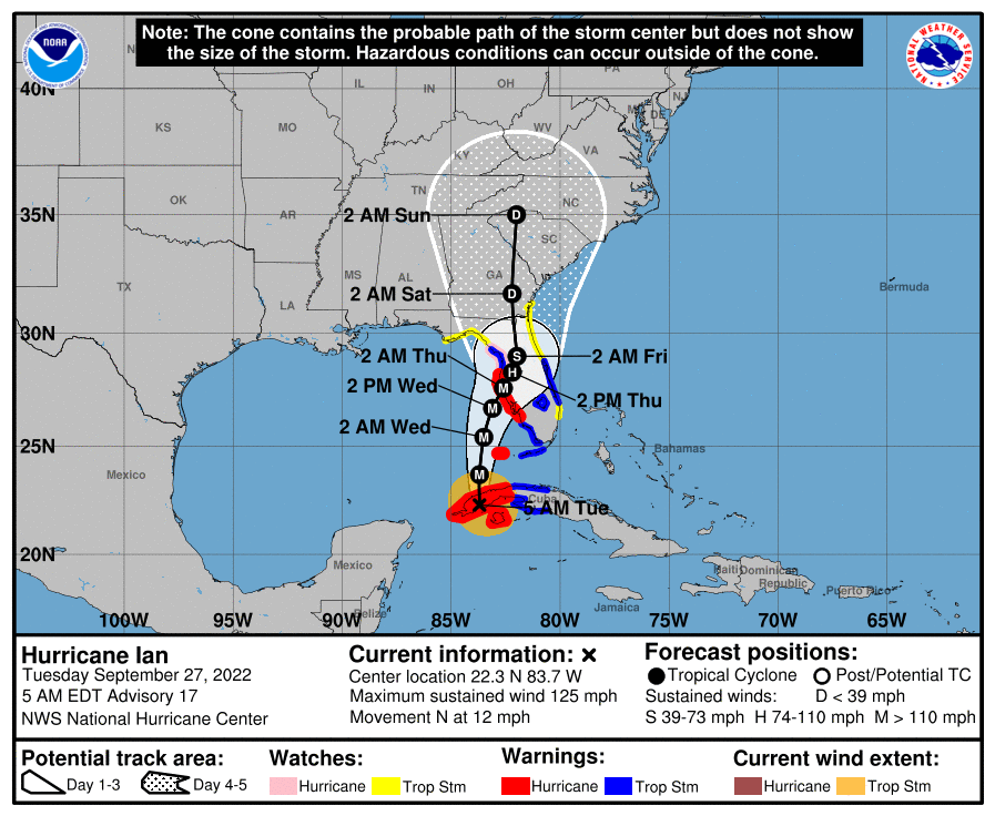
Good morning. The majority of the Houston region has dropped into the low 60s this morning as cool, dry air blankets the area. This week’s front will have sticking power as Texas falls on the backside of the extremely powerful Hurricane Ian, which will bring a catastrophic storm surge to southwest Florida later today. The slow-moving storm, with sustained winds of 155 mph, is the kind of hurricane that destroys communities. Frankly, this is the kind of storm I worry most about when I think of Houston and its vulnerabilities to tropical weather. We need to be ready to help Floridians in the days and weeks ahead.
Wednesday
Given Florida’s misery it feels almost guilty to write that Houston’s forecast looks absolutely splendid. Yes, today will be warm again, with a high of about 90 degrees beneath mostly sunny skies. But with continued dry air, we can expect nighttime lows to drop into the upper 50s for areas well inland, low 60s for the city, and slightly warmer conditions right along the coast. Winds will be out of the northeast at 5 to 10 mph.
Thursday and Friday
These should be the driest and coolest days of the week, as the northeasterly flow in the wake of Ian reaches its maximum. Look for sunny days with highs in the mid-80s, and lows dropping to around 60 degrees in Houston. This is just spectacular weather for late September.
Low temperature forecast for Saturday morning in Houston. (Weather Bell)
Saturday and Sunday
Mostly dry air remains in place this weekend, with highs generally in the upper 80s, sunny skies, and lows in the low 60s. As a reminder, we’re holding a Fall Day Celebration from 10am to Noon CT on Sunday at Houston Botanic Garden. See more details here. The event is free and you don’t need tickets. Please come by and say hello.
Next week
The air mass over the region will slowly modify next week as humidity starts to return. But it looks like nighttime temperatures will still be dropping into the upper 60s, so it’s not going to be a full-on return to summer-like weather. Some slight rain chances start to return to the forecast about a week from now, but they’re iffy at best.
Extremely powerful Hurricane Ian approaches Florida this morning.
Hurricane Ian
The category-5 hurricane now has sustained winds of 155 mph, and will make landfall near Port Charlotte in Southwest Florida this afternoon. It will push a surge of 12 to 16 feet of water into the state. Ian will then slowly track northeast across Florida for much of the next two days, bringing flooding rains and damaging structures will wind gusts well above hurricane force. There are three main threats from hurricanes—wind, surge, and inland rainfall—and unfortunately Ian is going to bring awful doses of all three in the next few days to Florida. The storm is then likely to move into the southeastern Atlantic Ocean and make a second landfall on Georgia and South Carolina Friday, albeit as a much weaker system.
Like some of you I am sure, being stuck in a cold house with my wife, kids, and mother-in-law in the middle of the February 2021 freeze was the tipping point for us. It was time to get a generator. Also like many of you as a result of the pandemic, we were in the middle of reassessing our living decisions and space needs around that same time. It was not until summer 2021 that we decided to move to West U and started exploring a generator for our new home.
Much like Eric did for his generator, and with his blessing, we used a portion of Reliant’s annual sponsorship to have a whole-home generator installed at the Lanza household. Reliant, of course, is the multi-year sponsor of Space City Weather. As in Eric’s case, my experience will reflect that of any consumer in my situation. We laughed, we cried, and it was not always pretty. But it got done.
Obviously, getting a generator is an investment. An average installation will likely run you between $10,000 to $15,000 depending on your home and needs, and that may have even nudged up a bit due to inflation. That said, I think we have learned from recent disasters both here in Texas and along the Gulf Coast that if you are able to purchase a whole-home generator, it will likely be a worthy investment. This is not something I really ever thought I’d do but having an infant and toddler roaming around a powerless house can change minds. My goal in this post is to describe the process of having a whole-home generator installed in a 2022 world, sharing how my experience differed from Eric’s that he wrote about last year.
Reliant works with a Houston-based company called Quality Home Products of Texas. To begin this effort, Quality sent a technician to my house back in November 2021. Joey was our tech, and he was extremely informative and knowledgeable about the process. We live in an older house (1940s) that has been modernized, so there were a few quirks about our situation in terms of wiring, logistics, etc. Those became an issue during the installation process, but broadly, Joey’s plan worked on paper. They were good at finding workable, minimally invasive solutions for a home’s unique situation.
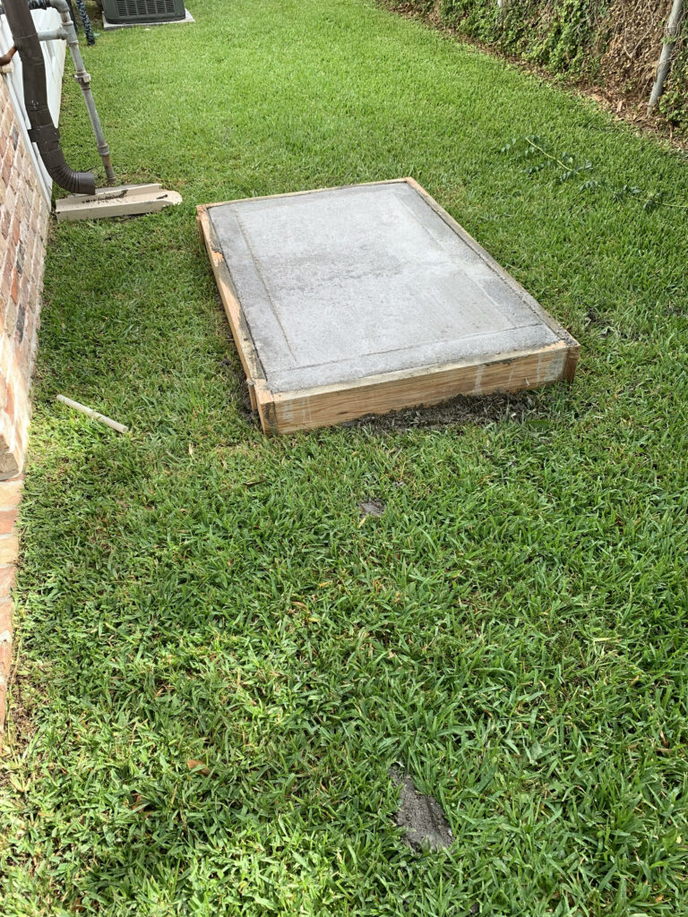
The first physical element of the process was getting a pad installed.
We outlined where the generator would go in our yard, placed some stakes in the ground, signed a contract and paid 25 percent of the total up front. Here is where my situation first deviated a bit from Eric’s experience. Eric’s home required a stand, but in our case a pad worked fine. To do this, workers came on two visits to construct the “outline” of the pad and then pour concrete. Both visits were quick, easy, and required little effort on our part.
The second difference from Eric’s experience was the Great Supply Chain Crisis of late 2021 and 2022. When we signed the contract in November, we were told that the process was going to be a bit delayed because of supplies. Apparently, a lot of folks want generators! The tentative timeline was that installation would probably be in February or March. Being fairly plugged into the news, I expected this, and it was just an inevitable outcome that was understandable. I appreciated Joey being honest about it up front.
Our gas meter upgrade was one of the thorniest parts of the process. It involved a bit of diplomatic navigation between CenterPoint and Quality Home Products, but once complete, it worked fine.
Then, as it turns out, our approval process in West U hit a delay. Thus, my installation was delayed another month or two in City Hall. Finally, we got the ball rolling in April, the pad poured in May, and the installation in June. So why am I writing this in September? A number of things: My schedule and a Covid outbreak in our house, then a number of minor issues that led to five- to seven-day delays each time. We had issues getting our gas meter upgraded with some back-and-forth between Quality and CenterPoint. The regulator necessary for gas supply to the house was installed a week before CenterPoint was able to come out to upgrade the meter, leading to hot water supply issues. We also had issues with how our HVAC system connected to the generator. We had a couple parts that needed replacing. My takeaway here: Inevitably, things happen so just be prepared to deal with that in this process. There were difficult moments, but Quality worked with us fully to navigate the issues and they got the job done.
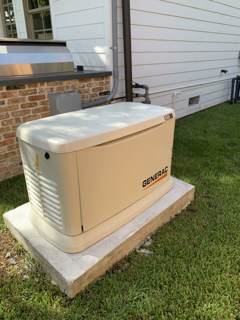
Ultimately, the generator was installed in June and we reached startup in late August.
The process of installing a generator provided ample headaches, but hearing it test itself on Mondays offers peace of mind that is tough to put a price tag on.
The installation process itself was about a half-day effort involving your power being cut for a couple hours in that time. Factor that into your plans if you work from home or want to avoid excessively hot or cold days. But overall, it was rather unobtrusive. The startup process was also straightforward. It does involve a brief power cut to test the generator. I got to see first-hand what would happen if we lost power, and admittedly it’s pretty cool. The power goes off, and within about 10 seconds, the generator turns on and life inside the home can resume a degree of normalcy. To ensure things stay operational, the generator is set to test itself once a week, and if anything is flagged, they’ll come out to see what’s up.
All in all, the installation process itself is not that bad. But it was a long road, and it certainly was not without a couple points of legitimate frustration. Despite a couple trip-ups, Quality does good work overall, and they have fairly comprehensive maintenance and monitoring services as well. All my interactions with their staff were positive. And to their credit, they apologized and explained the issues whenever things hit a snag.
If you decide to get a generator, plan ahead and prepare to be patient. Another piece of advice? Pay attention when they explain certain elements of the process. There may come a point where you have to explain to someone why something was done a certain way (like me trying to resolve issues between a plumber and CenterPoint). That can be taxing, but it will save you frustration. You don’t need to be an electrician or plumber to understand the whole process but ask questions and give the installers your attention.
Now, say a generator is not in the cards for you. There are alternatives to keep the critical functions of your home up and running in the event of power loss. Reliant is knowledgeable about these solutions as well and will work with you to find the right product for your lifestyle.
Goal Zero, Reliant’s sister company, provides numerous affordable and flexible power solutions, including portable power stations that can be charged through solar panels, power banks for smaller devices, lanterns and more – all perfect for when storms roll through or getting outdoors.
These devices can power everything from fridges and internet modems to phones, laptops and even critical medical devices. They can also integrate directly with your home’s circuits for a seamless experience.
In the event of a major storm or grid-related problems, portable backup power solutions will give you some peace-of-mind that you’ll have power to keep important devices charged and stay connected to family and friends.
• To learn more about backup power options, visit reliant.com/backuppower. (Reliant customers receive a 15 percent discount on Goal Zero products!)
Overall, I am grateful and relieved that this process is finally over. But as I said, while frustrating, the peace of mind we have now is tough to replicate. So was it worth it? I believe so. I also have confidence I can assist Eric in the event of a power-breaking storm! And that’s good for everyone.
Good morning. Every year at Space City Weather we like to mark the day following the arrival of the season’s first real cool front as “Fall Day,” and today is that day. Matt and I really feel that this should be a holiday in Houston, so this year we’re actually going to celebrate it!
He and I, along with everyone else associated with the site, are going to be host a “Fall Day” celebration at the Houston Botanic Garden on Sunday from 10 am to Noon CT. The event is free, and will have activities for kids and adults. Please come by and say hello. You can show your interest in the event by RSVP’ing here. This is not mandatory, of course, but it will help our planners at Reliant get a better idea of what to expect.
We’re holding the event on Sunday morning because it gives us time to organize activities along with the venue, which is a beautiful place to walk around and enjoy nature. While some of the drier air should be gone by then, Sunday should still be cooler and drier than a typical summer day, especially during the pre-noon hours. Hope to see you there!
Tuesday
Temperatures are starting out in the 50s north of Houston, while most of the rest of the region away from the coast is in the low 60s. With dewpoints down around 50 degrees it feels fantastic outside. Given this drier air and clear skies, our air will still warm efficiently this afternoon, with high temperatures reaching about 90 degrees. Winds are light, out of the northeast at 5 to 10 mph. Lows tonight should again drop into the upper 50s for inland areas, with much of the metro area in the low 60s.
Wednesday, Thursday, and Friday
The remainder of the week should bring more of the same: warm sunny days, clear and cooler nights, and plenty of dry air. Northerly winds may turn a bit gustier by Thursday or so, as our region falls on the backside of powerful Hurricane Ian. As a result, this will be the rare early fall front that not just hangs around, but brings even cooler weather a few days after the fact. Lows this week will probably reach their coolest level by Thursday night or Friday morning, when more of the region has a chance to dip into the 50s.
Low temperature forecast for Friday morning. (Weather Bell)
Saturday and Sunday
The weekend should bring more of the same, although with atmospheric moisture levels starting to rise again we will see a bit of humidity. Even so, right now I anticipate dewpoints to be in the 50s, which means the air will be much more comfortable than our typical, sticky summertime dewpoints in the 70s. Look for highs of around 90 degrees this weekend, with lows in the 60s. Rain chances remain near zero.
Next week
We’re probably headed back toward highs of around 90, with nights in the low 70s, by next week. While the air becomes more humid, at this point it doesn’t look to be oppressively so. Now that we’re entering fall we can probably expect a front every week or two, but there’s nothing concrete on the horizon after this week’s cooler air. The real sore spot in the forecast is the lack of rain, and right now I don’t have anything hopeful to say about that, I’m afraid.
Hurricane Ian is going to be a disastrous storm for Florida. (NOAA)
Tropics
Ian has strengthened to become a major hurricane overnight, and will emerge from the western edge of Cuba this morning into the warm southeastern Gulf of Mexico, where it will find low shear and conditions that support further strengthening. This will be a historic storm for Florida, with the potential for devastating storm surge in the Tampa area, as well as points south. Wind damage will also be extreme for some locations. And in a final gut punch, the storm will slow down with weaker steering currents as it nears Florida. Houston residents who remember Harvey know what this means, very heavy rainfall. I expect parts of the Florida peninsula to receive 20 inches or more of rainfall during the next three to four days.
My friends it has been a long—so very long —summer. We have seen record warmth in June and July, and plenty of high temperatures in the upper 90s during the last week. A total of 131 days have come and gone since Houston’s high temperature first hit 95 degrees this year, on May 18. Fortunately, I’m pretty confident that today is the last day of summer 2022.
Oh, we’re still going to see some 90-degree days. There will still be some humidity, of course. But our first real front pushes in today, bringing with it a nice surge of drier air tonight. By Tuesday morning it’s going to feel quite a bit different outside. No, the days won’t be chilly, but the nights will feel like fall. And the dry air is going to feel pretty amazing. Additionally, unlike a lot of early fall fronts, this one will have sticking power. The dry air should last into the weekend. So enjoy what’s coming, because you earned it.
Meanwhile, there’s likely to be a major hurricane coming to Florida this week. We’ll discuss that below as well.
Monday
There’s no way to sugarcoat the fact that today is going to be hot again. Expect highs to generally reach the low-90s across the region, with sunny skies. Light winds will turn to come from the northeast later today as the front pushes into the area. We don’t expect much (if any) precipitation with this front, and the bulk of the dry air will lag its passage, moving in tonight. Low temperatures tonight should drop into the mid-60s in Houston, with cooler conditions inland.
A dewpoint analysis on Monday morning shows a cold front on Houston’s doorstep. (Weather Bell)
Tuesday
You’ll be able to feel the drier air when you step outside on Tuesday morning. The lower humidity, combined with sunny skies, should allow highs to push into the upper 80s to 90 degrees, but temperatures will start falling fairly quickly after the sun goes down. Look for overnight lows in the mid-60s again in Houston, with cooler weather further inland.
Wednesday, Thursday, and Friday
If anything, the flow of drier air should become more pronounced during the second half of the week as Hurricane Ian moves into the eastern Gulf of Mexico. This should allow for warm, sunny days in the upper 80s and lows in the 50s (inland) and lower 60s for Houston. Mornings and evenings will be spectacular, y’all.
Friday morning could be the coolest of the week for Houston. (Weather Bell)
Saturday, Sunday, and beyond
By Saturday or Sunday, the onshore flow will probably start to reestablish itself. But at this point I still think we’re going to see sunny days in the upper 80s with at least somewhat drier air. Nighttime temperatures will start to warm, but should remain in the 60s. Highs next week probably climb back to around 90 degrees. I know we could really use some rainfall, but there appears to be precious little of that in the cards for the next 10 days or so.
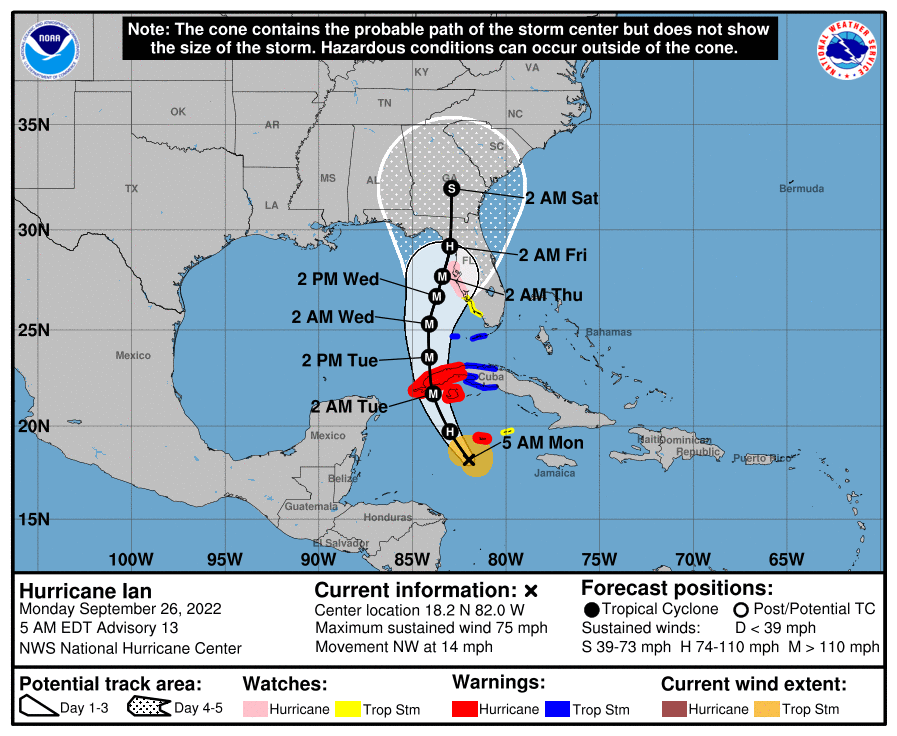
Hurricane Ian
Ian continues to organize this morning, and has become a hurricane. This is the Atlantic season’s fourth hurricane and confidence is high that it will cross Cuba tomorrow and move into the southeastern Gulf of Mexico. By Wednesday it should be approaching the Tampa area on the West coast of Florida, where it could bring historic wind and storm surge damage. However after Wednesday there is considerable uncertainty about whether Ian will plow into Tampa Bay, move more or less due north up the West coast of Florida, or remain 50 or 100 miles offshore while turning north for the Big Bend region of Florida.
Monday morning track forecast for Hurricane Ian. (NOAA)
I’ve been tracking the potential impacts on NASA’s Artemis I mission closely. The large Space Launch System rocket and Orion spacecraft remain on the launch pad at Kennedy Space Center, on the east coast of the state. At least minor impacts are likely, and Ian’s effects could become more direct. As of this morning, the probability of tropical storm force winds at the space center are 60 percent, with an 8 percent chance of hurricane-force winds. They could arrive as early as Wednesday. NASA officials are meeting at 11am CT today to decide whether to roll the Artemis I mission back inside the Vehicle Assembly Building to protect the vehicle.