Dry air for a few more days before “late summer” and decent rain chances return to Houston

Good morning. It is far from chilly outside, but dewpoints have dropped into the low 60s this morning for much of the region, and this dry air feels pretty nice. Houston will see a couple of more reasonably pleasant, dry-ish days before atmospheric moisture levels start to increase, some rain chances return to the region. This warmer, late summer pattern should hold on through most of next week.

Tuesday

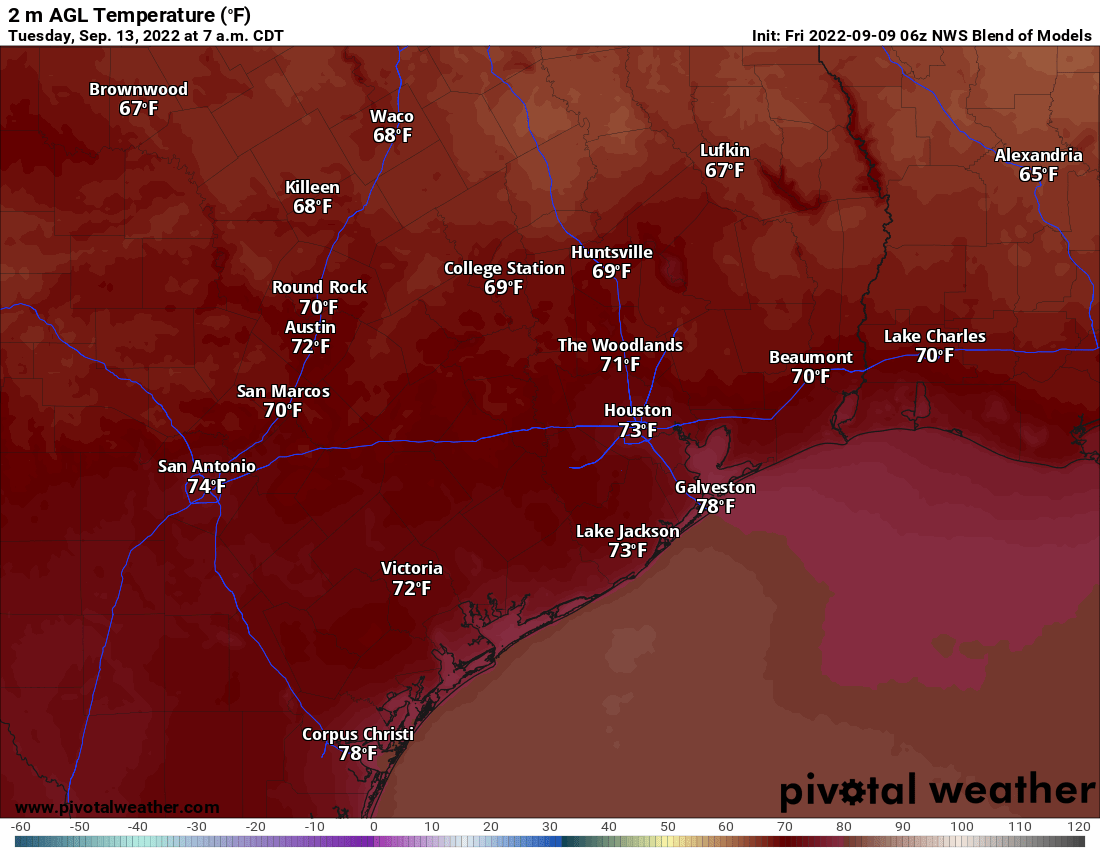
After starting out in the upper 60s to lower 70s this morning, daytime highs will warm into the low 90s beneath sunny skies. Winds will be generally light, out of the east, at about 5 mph. This evening should again be pleasant, with temperatures in the 70s and this somewhat drier air. Overnight lows will drop into the upper 60s for most of the region, away from the coast, with mostly clear skies.

Low temperature forecast for Wednesday morning. (Weather Bell)

Wednesday

Pretty much a carbon copy of Tuesday, with perhaps even slightly drier air, although I’m not sure this will be perceptible.

Thursday

This will be a bit of a transition day as moisture levels start to increase, and with it the potential for a few scattered showers near the coast. Look for mostly sunny skies otherwise, with highs in the low 90s. Overnight lows should be a few degrees warmer.

Friday, Saturday, and Sunday

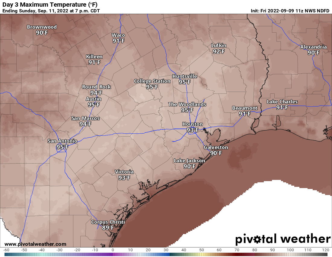
The weekend forecast has turned a bit more uncertain as the overall pattern now appears to favor a return to somewhat wetter conditions. Moisture levels will be highest near the coast, so we’re probably looking at daily rain chances in the vicinity of 50 percent for areas south of Interstate 10, and 30 percent or so further inland. I’m still anticipating mostly sunny skies otherwise, with high temperatures in the low 90s. Overnight lows should be solidly back into the mid-70s, with plenty of humidity, by this weekend. Hopefully we can pin down a more accurate weekend forecast for you by tomorrow.

Next week

Most of next week should continue to bring weather typical of late summer in Houston, which is to say warm days in the low 90s, and at least partly sunny skies. Rain chances will persist next week, but I’m not confident in whether they’ll be low, or or bit higher than that. The forecast models are starting to hint at the potential for another cold front about 10 or 11 days from now, but I probably wouldn’t even write that down in pencil yet, let alone ink.

Tropics

Fourteen years ago, today, Hurricane Ike made landfall along the upper Texas coast. This remains the region’s worst storm surge event during at least the last half century. I remember it distinctly, listening to the winds howl through the skyscraper-lined streets of downtown Houston. Happily, the tropics are quiet today.

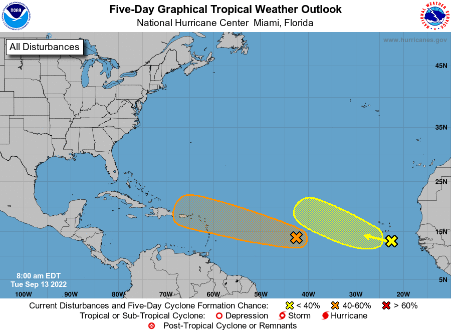
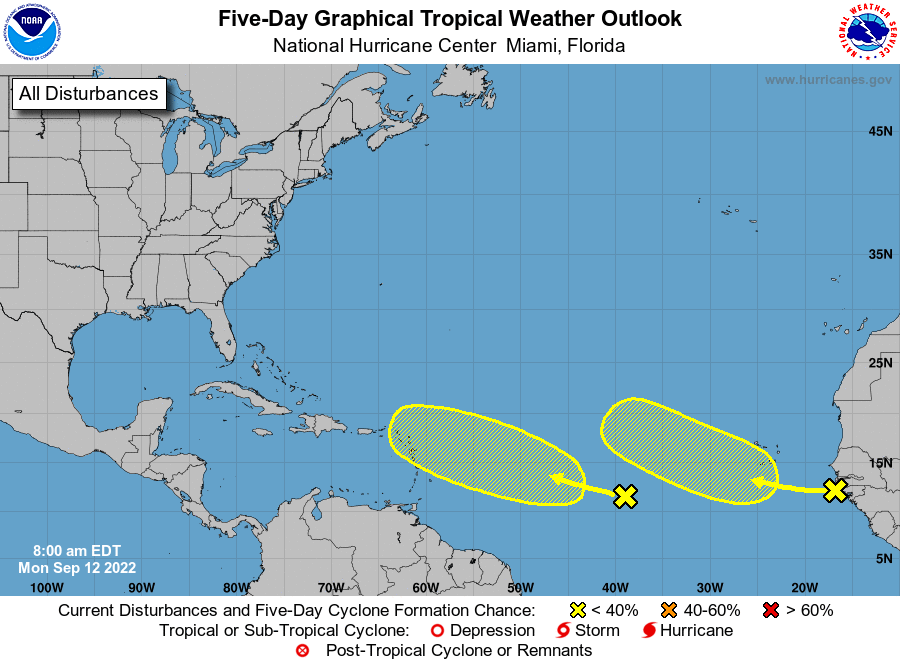
As I wrote in a dedicated hurricane post on Monday, we’re getting close to the end of the Texas hurricane season, but we’re not quite there yet. We’re continuing to watch a tropical wave in the Atlantic (noted in orange above) that has a chance to get into the Gulf of Mexico next week. I think the chance that this system affects Texas is rather low, but given the time of year we’ll be watching it closely regardless.

We are in the home stretch of hurricane season for Texas

There is no doubt it has been a blessedly quiet Atlantic hurricane season. Overall activity is running less than half of “normal” for the Atlantic basin this summer, and this is all the more remarkable given that forecasters predicted a significantly busier-than-normal season in 2022.

From a climatological standpoint, the Atlantic basin passed the peak of hurricane season on Sept. 10. Typically, during any given year, nearly 50 percent of tropical storms and hurricanes will form between now and the end of October. For Texas, the timeline is still more compressed. Our chances of being struck by a hurricane fall dramatically after about two weeks from now. So we’re close, but we are definitely not there yet.

The National Hurricane Center is tracking to tropical waves as of Monday morning.

Two waves

The Atlantic tropics are really quiet for this time of year, with the National Hurricane Center tracking just two tropical waves—these waves are not in the ocean, by the way, but rather are low pressure systems in the atmosphere with the potential to become tropical systems. Each has a 20 percent chance of developing into a tropical depression or storm during the next five days. Of these systems, the one we probably need to watch is the closer of the two to the United States.

At present this is a disorganized area of showers and thunderstorms, but it may find reasonably favorable conditions for development later this week. By around Sunday, something could form near Puerto Rico. In fact, there is decent agreement among many of the European model ensemble members in support of a weak system. After that point, who knows? The system might never develop. It might fall apart. It might move into the Gulf of Mexico. Or it might curve northward toward Florida or the Southeastern United States.

European model forecast for tropical low locations on Sunday, Sept. 18. (Weather Bell)

The other potential threat during the next 10 days is some sort of development in the Bay of Campeche that may have some pathway to move north in the Gulf of Mexico.

To be clear: Neither of these systems, at this point, appear to pose anything remotely close to a significant threat to Texas. The present quietude of the tropics, at this time of year, is truly a blessing for North America and the Caribbean Sea. But that doesn’t mean it will last, and during the last two or three weeks of prime tropics time for Texas, we do have a couple of things to watch. Hopefully, in two weeks, I’ll be writing a post saying that we’re pretty confident we’re done with hurricane season in Texas.

A message from our sponsor, Reliant

Reliant stands ready to support Texans and help them prepare for any storms that come our way. Especially in a relatively quiet period, it’s important to take the time to protect your
family, home and business in advance. Reliant’s Storm Preparedness Checklist is a good place to start.
Here are a few other tips to keep in mind as you prepare.

• Reliant offers a wide range of backup energy solutions to help you ride out the storm:

• Have power at the ready—at home or on the go—with Goal Zero portable charging
products. They can charge everything from phones to fridges and even life-sustaining
medical devices.

• Replacing electronics damaged by a power surge can be costly. Help offset the cost by
investing in Reliant Surge Protect, starting at less than $5 a month.

• Be prepared in case of an electricity outage. Your utility company (like CenterPoint in the
Houston area) maintains the power lines, utility poles and electricity infrastructure necessary to
deliver the power you purchase from Reliant to your home. Contact your utility company to
report an outage or check the status of the repair.

• Check out more preparedness tips and recovery resources at ReliantStormCenter.com. The site
provides resources for before, during and after a storm, including preparedness checklists and
evacuation routes, weather and power outage updates, flood maps, safety tips and more.

Storms are a part of life in Texas, so being prepared is critical. Like everyone else, we are
grateful this season has been a quiet one so far, but Reliant and Space City Weather will be here
for you regardless.

A weak cool front is bringing drier air to inland parts of the Houston region

Good morning. A much discussed, but rather weak front has pushed through Houston overnight. This will bring a few cooler and drier nights to the region, especially for areas north of Interstate 10, further away from the influence of the Gulf of Mexico. Some decent rain chances return by Thursday or Friday for coastal areas, but for now we expect these to take the form of mostly scattered showers rather than anything organized.

Monday

High temperatures today will reach the lower 90s for most of the metro area, with sunny skies. Winds will be light, generally out of the north, at about 5 mph. Conditions this evening will be pleasant, relative to typical summertime conditions, as dewpoints drop into the mid-60s for most of the region away from the coast. This is not dry air by any means, but it is drier than we’ve been experiencing. Lows Monday night should drop below 70 degrees for inland areas, with low 70s closer to the coast.

Forecast low temperatures for Tuesday and Wednesday (shown) above will be lower than we’ve seen. (Weather Bell)

Tuesday

Highs will again be in the low 90s on Tuesday, with sunny skies. If anything, the air should be a smidge drier during the daytime and Tuesday night, so expect another pleasant evening across the area, heading into Wednesday morning.

Wednesday

The dry air lingers into Wednesday, and this morning has the potential for the lowest temperatures of the week, with lows possibly in the mid-60s for areas well inland. Expect another day with sunny skies, and highs in the low 90s.

Thursday and Friday

By later on Wednesday, some time, the onshore flow should reestablish itself, leading to more humid conditions. For coastal areas, this moisture, in concert with the sea breeze, could start to generate some afternoon showers and thunderstorms. Rain chances will be significantly less for areas inland of Interstate 10, however. Highs should be in the low 90s for much of the region, with mostly sunny skies.

NOAA’s rain accumulation forecast for now through Sunday suggests we’re in for a dry week. (Weather Bell)

Saturday and Sunday

This pattern will probably persist into the weekend, providing us with mostly sunny skies and highs in the low 90s. Rain chances, overall, look to be fairly low this weekend so plan outdoor activities with confidence—and plenty of bug spray.

Tropics

I’ll have a full roundup of tropical activity in a post later this morning, looking ahead at what to expect for the next week or 10 days as we start to approach the likely end of hurricane season for Texas.

Significantly less drought coverage for the Houston area

The updated drought monitor report was released yesterday, covering us through this past Tuesday, and it had good news for our area as drought conditions have been significantly ameliorated.

Use the slider to see the week over week change in drought conditions in the Houston region. We see much less drought coverage and intensity this week. (NOAA)


We have gone from 74 percent drought coverage a week ago to 35 percent this week. Most of the area is now drought-free. Of course, it’s not completely gone, and with primarily dry weather expected for another week or more, it stands to reason that we could slip back into a worsening drought situation again this autumn. But for now, we’re doing much, much better. The same is true for much of Texas.

Friday & weekend

The next three days are all going to be variations on the same thing: It will be mainly sunny. You probably will not get rain, but there is at least a slight chance each day that someone will. It will be hot but not extremely so. I do think the next few mornings and evening will be moderately pleasant, much like we’ve seen at times over the last week or so, but the middle of each day should be plenty hot, with highs generally 90 or better away from the coast and mid-90s well inland.

Forecast highs on Saturday and Sunday (shown) will be 90 to 95 degrees across the area, so still pretty hot. (Pivotal Weather)

All in all, if you have plans this weekend, you should be in pretty good shape.

Monday through Wednesday

Will it or won’t it? That’s the big question. We have been discussing the chances that a faux fall cold front could push through Sunday night or early next week and provide us with a taste of autumn and somewhat drier air. Models are still roughly 50/50 on whether or not it gets here. This won’t have much moisture or much impact beyond primarily determining whether we see nighttime lows in the 60s over much of the area or continued 70s.

Model forecast lows on Tuesday morning are close but not quite there for this to be considered our first fall front. It will be a close call. (Pivotal Weather)

So for now, look for mainly sunshine Monday through Wednesday with a slight chance of a shower or storm. Daytime highs should be in the 90s and nighttime lows generally still in the 70s, but risk for a morning of 60s in there, mainly north of I-10. We will see where we stand on Monday.

Mid to late next week

Whether or not an actual front gets here is somewhat inconsequential to the rest of the forecast next week. Look for sun, clouds, building warm to hot temps again, and more late summer humidity. Rain chances remain on the low-end of the scale for most of the rest of next week.

Tropics

The good news is that the Gulf continues to be free and clear of any tropical activity over the next week or so. Everything is in the Atlantic.

Hurricane Earl, along with all the other 20 to 30 percent chances of developing over the next 5 days should stay in the Atlantic. (NOAA/NHC)

All the systems worth watching in the Atlantic seem likely to stay there for their life cycles, which is surely good news for us. We’re not to the finish line yet, so I’m not quite ready to exhale, but we’re getting closer. For those that follow me on social media, the H-E-B cocoa granola supply remains full. Fingers crossed it stays that way.