Good morning. Houston will see a couple of days with slightly reduced rain chances, before the potential returns on Friday and persists through Labor Day weekend. We still don’t see any signals for anything beyond street flooding, but the holiday weekend will be marred by on-and-off showers and thunderstorms, some of which will be at-times heavy. If you have outdoor plans I hope they include easy access to shelter from such storms.
Wednesday
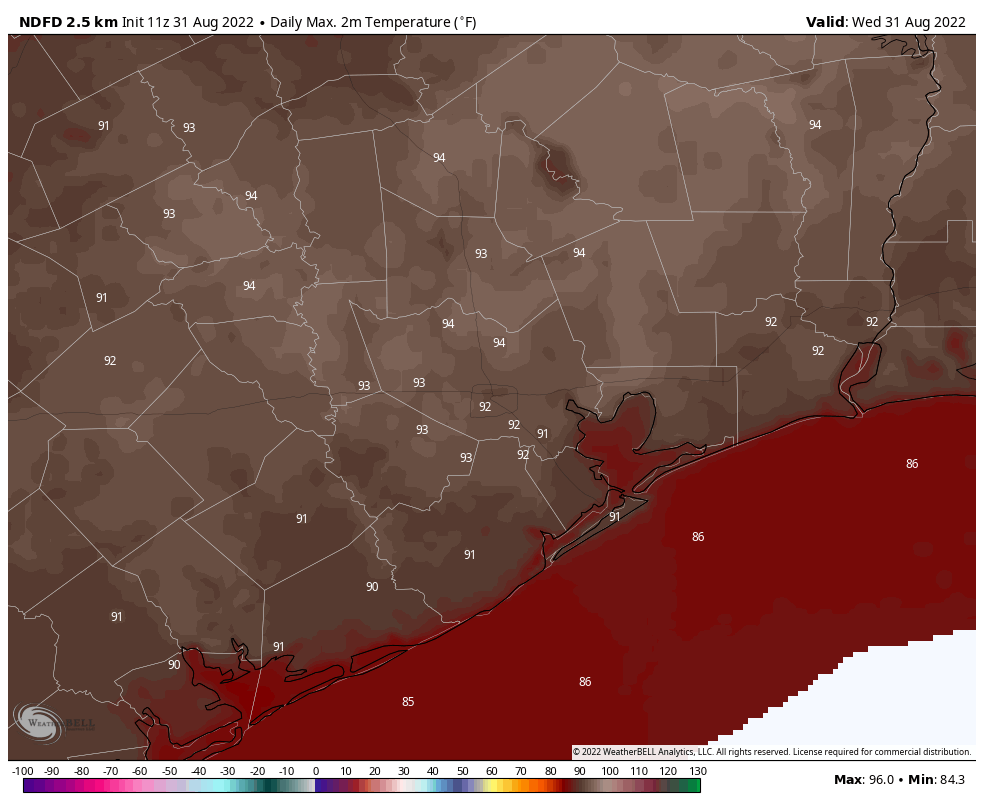
Conditions in the atmosphere are a bit less favorable for heavy rainfall today, but there’s still plenty of moisture to work with. Therefore while showers and thunderstorms will be somewhat scattered today, they’re still going to develop, and move generally from southeast to northwest. Areas west of Interstate 45 are slightly more favored for rain today. With partly sunny skies I think we’ll see highs this afternoon push up into the low-90s, or possibly mid-90s for areas well inland. Winds will be light, from variable directions, but mostly out of the southeast.
Wednesday and Thursday of this week will be the region’s hottest days for awhile. (Weather Bell)
Thursday
This will be another day lacking ideal conditions for heavy rainfall, but we’re still expecting about 50 percent of the area to see some form of precipitation, including a few stronger thunderstorms. Otherwise, expect partly to possibly mostly sunny skies, with highs in the low- to mid-90s.
Friday
Rain chances increase a bit during the day on Friday, and an increase in cloud cover should limit temperatures to the low-90s.
Labor Day Weekend
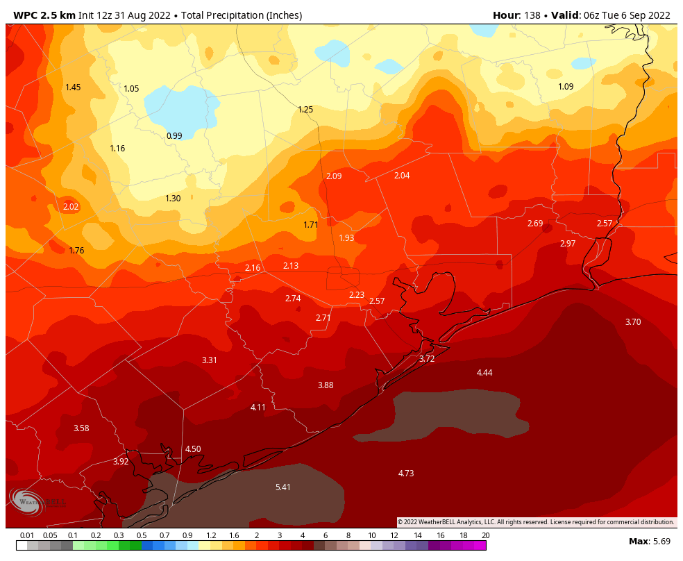
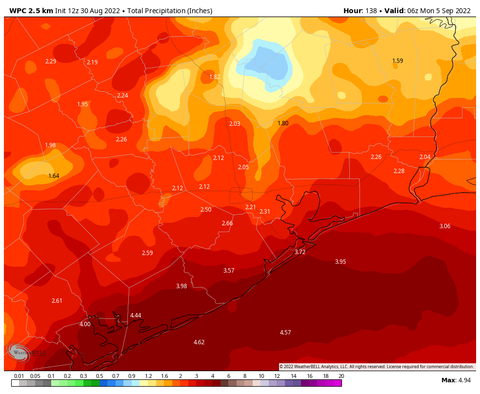
A weak front will nudge down into the area from the northeast on Friday night, and as this front more or less stalls over the Houston region we’ll see a period of unsettled weather this weekend. (The front is going to do nothing for our sticky humidity or warm nights, alas). Areas north of Interstate 10 will probably be little drier than the coast, but most of the metro region should see 2 to 4 inches of rainfall through Monday with on-and-off showers. Some areas will, of course, pick up higher amounts. The increased cloud cover and rain-cooled air should help to limit high temperatures to the 80s for most of the region.
NOAA rain accumulation forecast for now through Labor Day Weekend. (Weather Bell)
Next week
Honestly, this unsettled pattern does not look to change a whole lot next week. We should continue to see at least partly cloudy skies, healthy rain chances, and highs in the upper 80s as we get a little deeper into September.
Tropics
There remain no threats to the Gulf of Mexico for at least the next week or so, if not longer. This has been a remarkably quiet hurricane season. In fact, if there is no tropical cyclone in the Atlantic basin today, this would be the first August without a named storm since 1997. That is not a complaint.
Good morning. It has rained nine of the last 11 days at Bush Intercontinental Airport, and 10 of the last 11 days at Houston’s Hobby Airport. While some of us may be getting a little tired of rainfall, I would remind you that the alternative in late August is blazing hot sunshine and temperatures near or above 100 degrees. We saw plenty of that in June and July, when record heat scorched the region. Whatever your preference is, the rainy-gray skies-cooler temperatures pattern will prevail for some time. We’re even going to get a weak front later this week to keep daytime temperatures on the lower side of things. Alas, this front will have almost no impact on nighttime temperatures or dewpoints. Hopefully, however, we will get our first real fall front within the next four weeks. Fall is not all that far away!
Tuesday
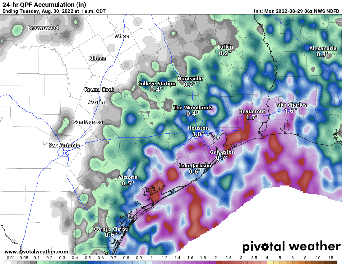
On Monday, much of the west side of the region saw significant rainfall, with two or even three inches of rain in southwest Houston and parts of Fort Bend County. After a wet few weeks our grounds are getting soggy, and less able to absorb higher rainfall amounts. The good news is that, while our region remains in a wet pattern, we’re not seeing too much of a signal for slow-moving, heavy rainfall that will dump inches at a time, and lead to significant, widespread flooding. However, we will definitely have a chance for street flooding today where heavier rains set up. That appears most likely for areas west of Interstate 45 on Wednesday, where a few spots may see 1 to 3 inches of rain, with lesser amounts for most other parts of the region. Otherwise, expect highs in the upper 80s with light southerly winds.
NOAA rain accumulation forecast for now through Sunday. (Weather Bell)
Wednesday
The overall pattern remains the same for Wednesday, with a few areas likely to see heavier rainfall and lesser totals for much of the rest of the region. Expect partly to mostly cloudy skies with highs in the vicinity of 90 degrees.
Thursday and Friday
The aforementioned weak front approaches the northern reaches of the metro area on Thursday, and this shift should bring some slightly drier air into the atmosphere. This may knock daily rain chances back to 40 or 50 percent for the region, and I think we can expect daily high temperatures in the low 90s for the most part with partly sunny skies.
Labor Day Weekend
Unfortunately the forecast for Labor Day weekend is not super for outdoor activities. The aforementioned front will essentially stall out over Houston, and this will support rainy conditions. Rain chances each of the three days over the long weekend will probably be on the order of 60 percent, or so, with the potential for a few areas to see downpours. Skies will be partly cloudy, with highs in the upper 80s to 90 degrees. Looking ahead to next week, at this time I don’t see much changing in terms of our slightly cooler days with higher rain chances. This pattern looks locked in for awhile. Summer came in with a bang, temperature-wise, and it’s going out with a whimper.
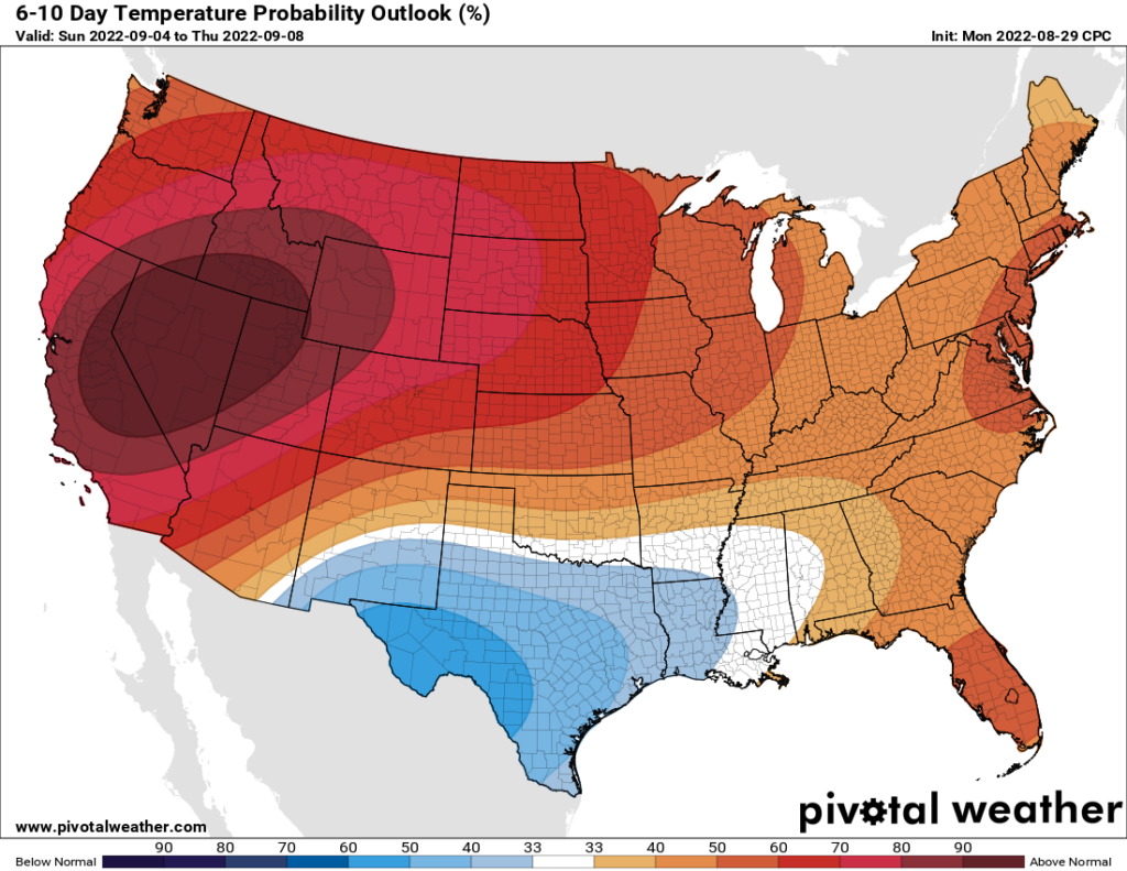
Next week should continue to bring near- or cooler-than-normal weather to Texas. (Pivotal Weather)
Tropics
Matt has done a fine job of summarizing the Atlantic tropics in recent days. The bottom line remains the same: While the Atlantic basin is heating up we don’t see any near term threats to the Gulf of Mexico. That’s a fine posture to be in as we reach the end of August.
Meanwhile, today has the potential to be a bit of a slog in spots due to rainfall. I think most areas will see at least some rainfall today, and some of it could be quite heavy, leading to pockets of street flooding. We are holding back on a flood scale upgrade to Stage 1 right now, but there will probably be a few neighborhoods that see a little water on the streets for a time today.
Today
Showers and storms are already marching inland past I-10 as of 6:45 this morning. Coverage should continue to expand northward through the day, and again, we do feel that much of the area will see at least some rainfall today. Areas south and east of downtown Houston will have the highest odds of heavier rainfall, and this would probably include the Beaumont and Port Arthur areas as well.
Areas north and west of Houston will average less than an inch of rain today (though some could see isolated higher amounts), while areas south and east of Houston will average around an inch or two, with higher amounts possible. (Pivotal Weather)
Look for an average of around a half-inch area wide today, with a bit less north and west and a bit more south and east. Isolated areas that see repeating rainfall could easily see 3 or 4 inches or a bit more today, again most likely south and east of Houston. Street flooding is the main concern, and while we are not issuing a Stage 1 alert, just be mindful of that potential in spots today. We will monitor the rainfall situation and update or escalate as needed today.
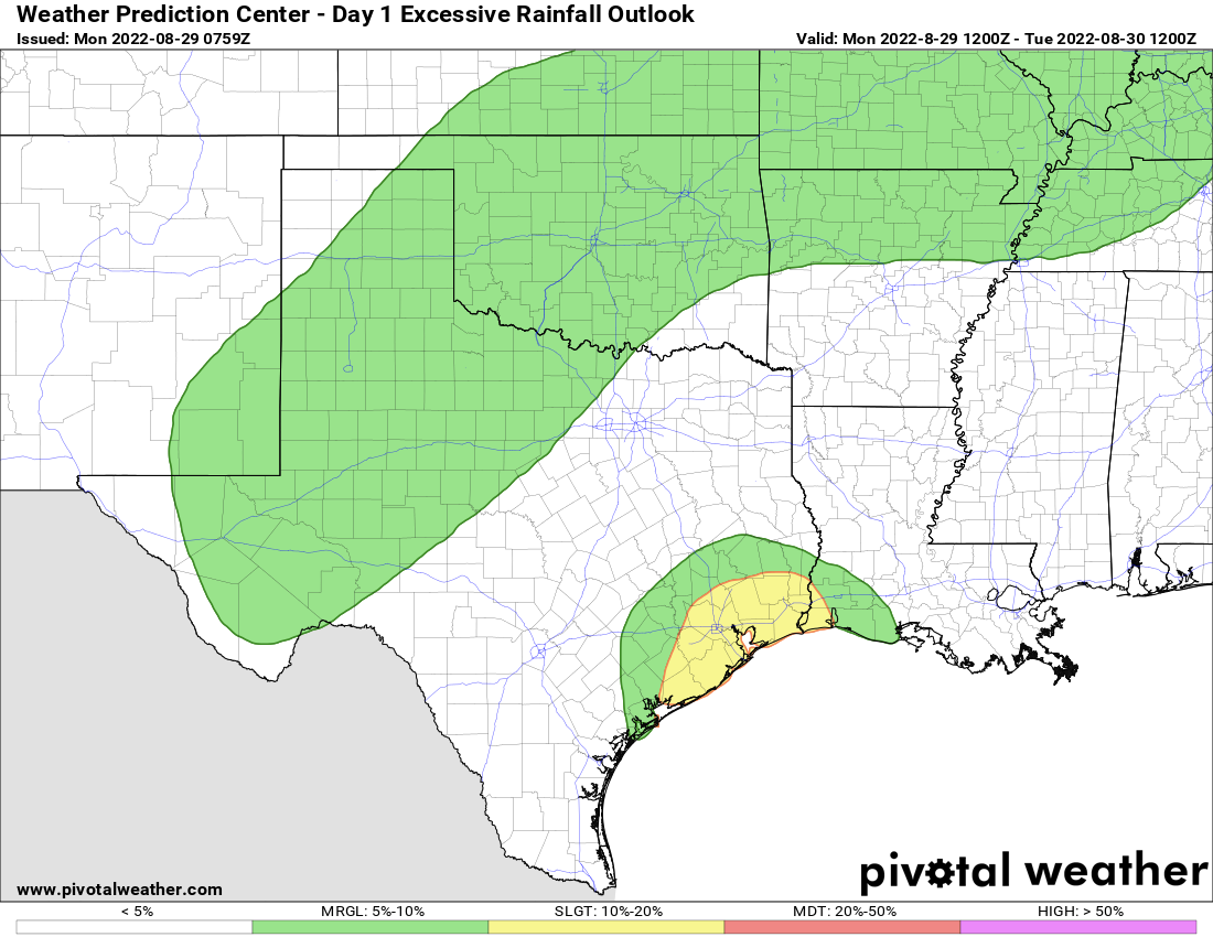
The Houston area and points south and east are in a slight (level 2/4) risk for excessive rainfall today, which could lead to localized flash flooding. (Pivotal Weather)
Clouds and showers will likely keep temperatures held way back today with 80s for most and some low-90s well inland and toward College Station.
Tuesday
The pattern remains quite favorable for locally heavy rainfall tomorrow too. Look for scattered to numerous showers and storms throughout the day. By their nature, not everyone will see rain again tomorrow, but those that do may see some pretty healthy rainfall. More on this Tuesday morning.
Rest of the week
Things do look to calm down a bit Wednesday through Friday, as we revert to more of a typical pattern of daily showers and storms associated with the sea breeze and daytime heating. Some of the rain will be heavy, but the most common areas to see heavier rain will be south and east of Houston. Daytime highs will be near average to perhaps a tick cooler than average, with upper-80s to near 90 degrees and lows in the 70s.
Labor Day weekend
At this point, we expect more of the same. The good news is that the models that had been aggressive in developing a tropical system near the Yucatan late this week and weekend have backed off a bit in the last 24 hours. This means there should almost certainly be no impact on Texas’s Labor Day weekend outlook from that, just scattered showers and storms each day, with highs within a degree or two of 90 degrees.
Rest of the tropics
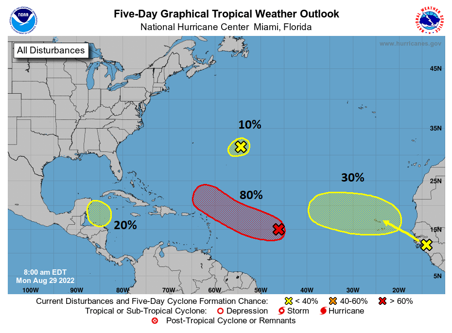
The rest of the tropics continue looking active today. There are four areas to monitor on the National Hurricane Center’s five day outlook.
While the tropical Atlantic is picking up in action, none of these four areas that are being monitored look particularly concerning for the Gulf. (NOAA)
The good news for us? As noted in yesterday’s tropics outlook, none of these areas is of particular concern for Texas or the Gulf Coast. We’ll continue to monitor, particularly the one that may develop near the Lesser Antilles, but at this time, there is nothing in any model guidance that concerns us for the next week or more.
Happy Sunday, everyone. I wanted to dedicate a special post to the tropics today because there’s a lot happening, and we just want to let you know where things stand with each area we’re watching.
Tropical outlook in a sentence
We expect activity to crank up a bit this week, with potential for a named storm or two, but at this time none of these is a direct threat to the Houston area.
Quick overview
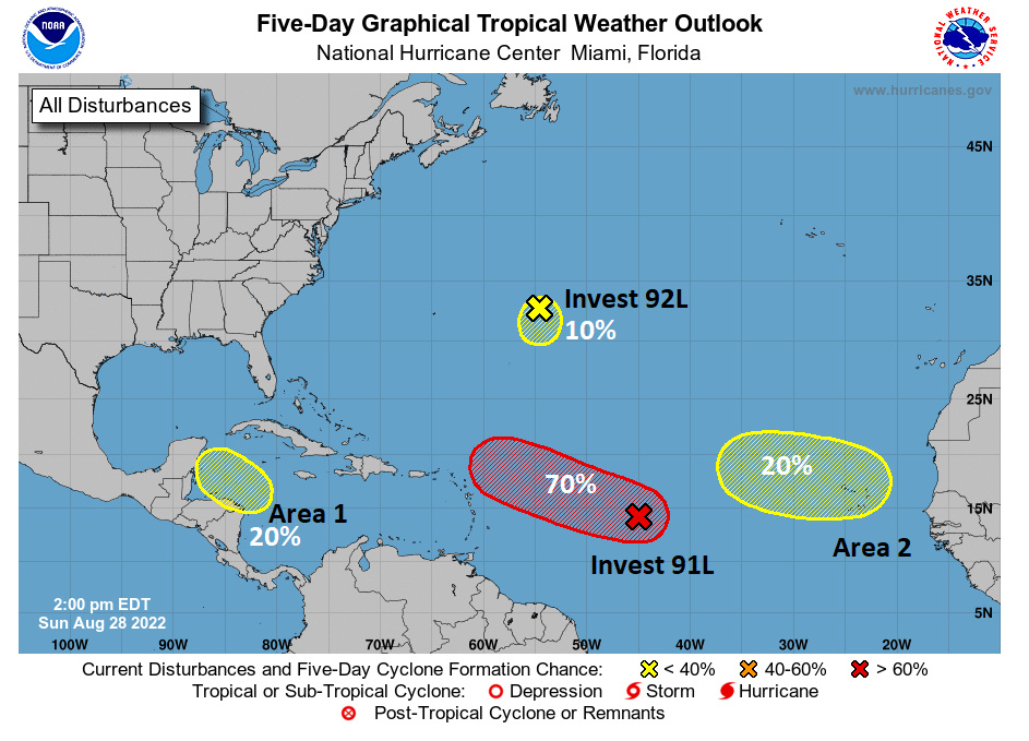
As of Sunday afternoon, the National Hurricane Center has four areas highlighted for potential development over the next 5 days.
The NHC is tracking 4 areas for possible development over the next 2 to 5 days, however only one has high odds. (NOAA)
In addition to these four areas, there are some things in the Gulf to watch but none that are likely to develop tropically. We’ll get to all these areas now. Use the map above as your guide.
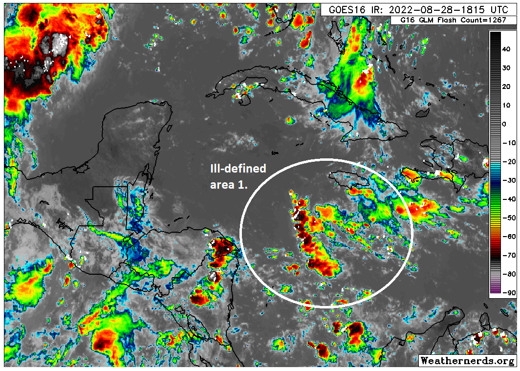
Area 1 in the Caribbean
Is this a concern for Texas? Not really, but it may help contribute to some rainfall next weekend or after Labor Day
The main area we’ve been watching for a few days now is a disturbance that’s heading into the northwest Caribbean. The GFS model latched onto this system last week, incorrectly it turns out, and was trying to bring this into the Gulf as a substantial storm on occasional runs. Models seem to have latched onto this now and favor a track that’s a bit farther south and into Mexico. Whether it becomes a system or not remains to be seen.
The 20% area of interest in the Caribbean is struggling a bit at the moment. (Weathernerds.org)
It certainly has a long way to go based on the satellite image above. Why are we confident in this likely staying to our south? Well, for one it’s disorganized. Weaker systems will be less apt to gain latitude and will continue generally off to the west or west-northwest across the Caribbean. The longer this takes to organize, the narrower that exit ramp becomes until perhaps it’s too late and it ends up being forced into Mexico or even Central America.
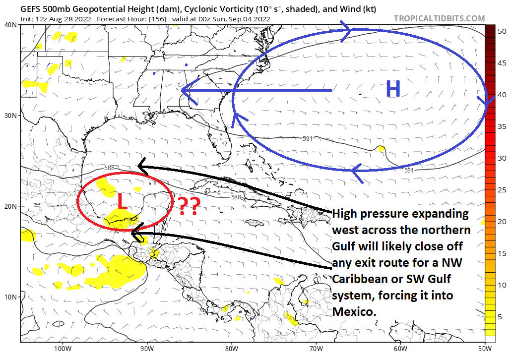
Even in the case of the more bullish GFS model, one look at the ensemble tells you all you need to know. Wherever the low is this Saturday evening; be it west of the Yucatan over the Bay of Campeche or just approaching the Yucatan, as high pressure builds across the northern Gulf from Bermuda, it will seal off the northward exit door, and even a stronger system would likely be forced into Mexico here. And again, that’s assuming the GFS is correct on developing this…a bit of a stretch right now.
The weather map 20,000 feet up on Saturday next weekend shows that any chance of this system coming north appears to be quickly closing, leaving it to go into Mexico or Central America and unlikely to impact Texas. (Tropical Tidbits)
So, at this point, the only real thing this might do in Texas is bring us some rainfall enhancement later next weekend or just after Labor Day. Obviously, we’ll watch for any changes, but at this point, we have limited concerns regarding this system.
Invest 91L
Is this a concern for Texas? At this time, we do not believe this will impact the western Gulf at all.
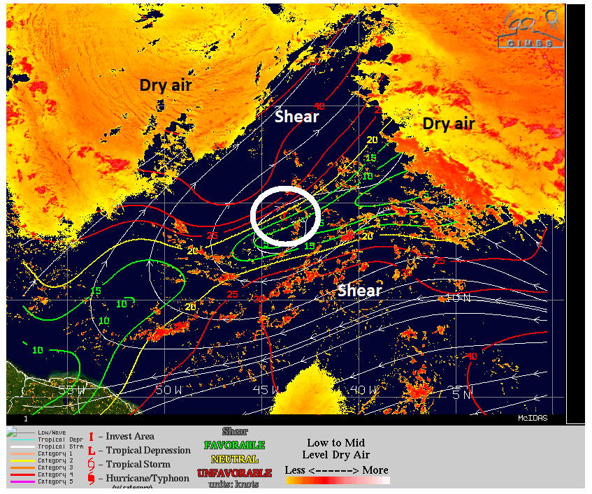
Invest 91L is likely to garner most of the headlines this week. It has the highest chance to develop right now, and it’s likely to be the one that comes closest to the U.S. This one is going to be a bit of a challenge to predict I think, as the steering currents around it, and the organization of the system itself will ultimately impact its track and both seem complicated.
In the near-term, this thing has to fight dry air all around it, compounded in part by pretty aggressive wind shear on either side.
Invest 91L in the Atlantic is fighting both shear and dry air, both of which probably will keep any development slow. (University of Wisconsin CIMSS)
Over the next 3 to 5 days, as this comes west and west-northwest to just northeast of the Lesser Antilles, it will then likely start feeling the effects of shifting steering currents. Initially, those steering currents may keep an exit door open for 91L to turn out to sea. But if it’s too weak to gain that much latitude, it will stay in place and may actually get turned a bit back to the west again, bringing it a bit closer to the Bahamas or Florida perhaps. This would be the result of that high pressure shifting west across the northern Gulf that helps keep area 1 away from Texas. It may also cause it to slow down some as well.
From there, it’s anyone’s guess. At this point, I am not expecting anything major from this, but it’s worth watching in the Southeast or the larger Caribbean islands and Bahamas. But any impacts in those locations are at least 6 to 8 days away. Never say never, obviously, but at this point it seems unlikely to get to the Gulf.
Invest 92L
Is this a concern for Texas? No.
The second invest in the Atlantic is chilling east of Bermuda. It’s no threat to any land mass at this time, and any development would be slow and probably weak.
Area 2 in the deep Atlantic
Is this a concern for Texas: Not right now, and probably not at all.
The last area of note from the NHC is in the far eastern Atlantic. Right now, things are a bit of a sloppy mess out there, with storms, tropical waves, and more — but nothing organized.
It’s tough to make sense of anything in the eastern Atlantic right now, but we’ll continue to watch. (Weathernerds.org)
What exactly happens out here is TBD. Models are convinced something should come of this, but none of the model data looks especially significant at this point. Some even turn this out to sea before it even gets halfway across the Atlantic. Whatever the case, this is so far away and so disorganized right now, that there’s little we can intelligently say about this area. So we’ll leave it at that for now.
The Gulf
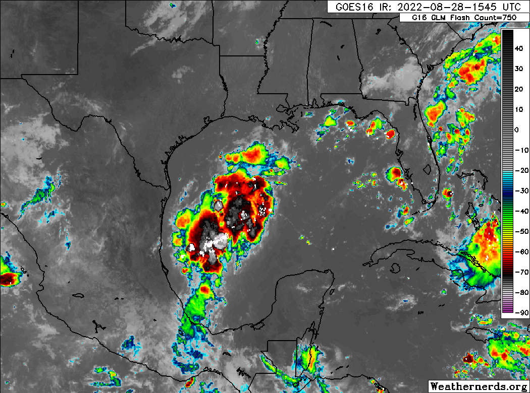
As of Sunday afternoon, there are no areas of interest outlined in the Gulf by the NHC. Looking at satellite here, that may be somewhat tough to believe.
A large blow up of thunderstorms continues to fester in the Gulf of Mexico. But while it looks rather ominous, no development is expected from this area. (Weathernerds.org)
That area of thunderstorms looks better than anything in the tropical Atlantic that’s outlined at this time. But looks are sometimes deceptive. While certainly there is a lot of storm activity in the western Gulf, there is no organization to this area right now, nor is there expected to be. This moisture is expected to come north and northwest over the next 36 hours, and this is likely to enhance our coverage of showers and storms tomorrow and perhaps Tuesday, particularly along the coast but perhaps inland as well. We’ll have more on this for you in our usual Monday morning post, but keep your umbrella handy tomorrow.
Aside from that, the Gulf looks quiet. There are modeling hints of something trying to emerge out of Central America after Labor Day, but it’s so far out and has such modest model support right now that it doesn’t make sense to speculate beyond the fact that we’re always monitoring things this time of year. We’re good this week, and we’ll keep tabs on all the things out there as the week progresses. As good a report as you could ask for on August 28th. More for you tomorrow AM!