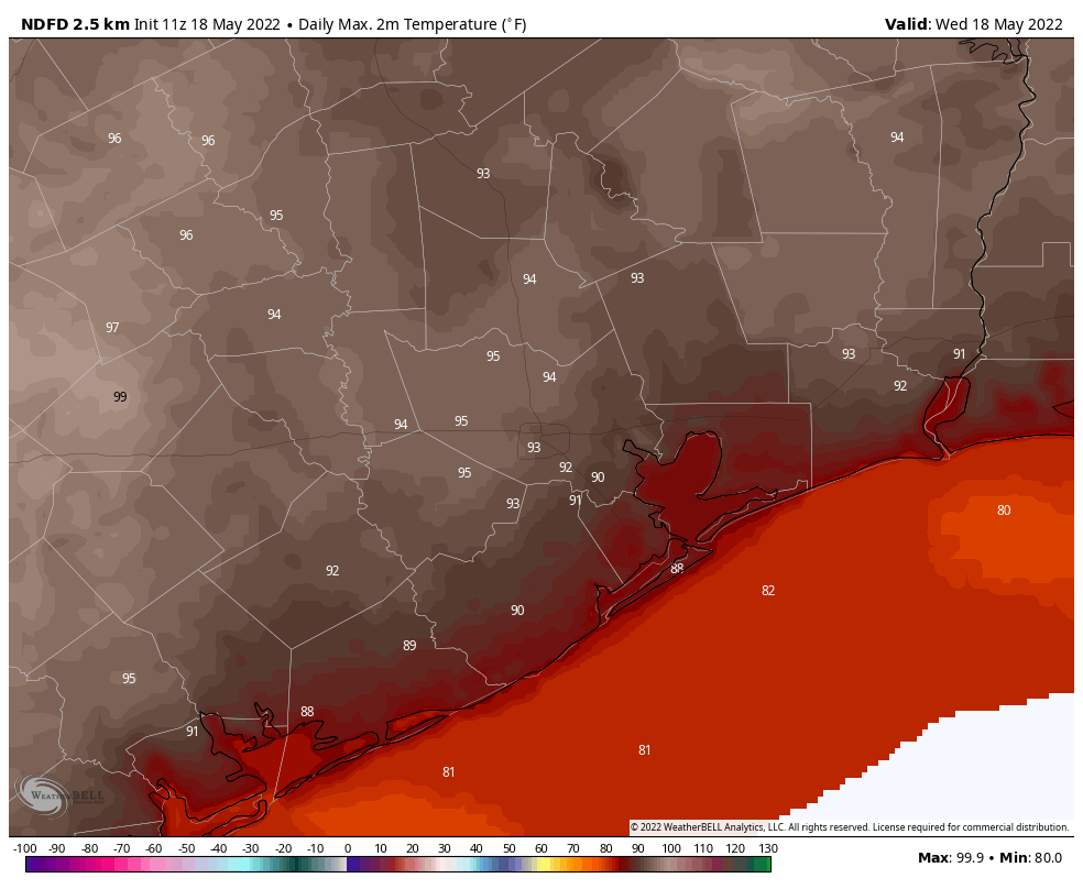
Hi all. Just a short weekend update to note the potential for some reasonably strong thunderstorms late tonight as a cold front pushes into the region. Today will be hot and mostly sunny, with highs in the low- to mid-90s. Winds will be gusty out of the south, so it will be pretty much business as usual in terms of our recent weather. But conditions will begin to change tonight with a significant pattern change.
Saturday night
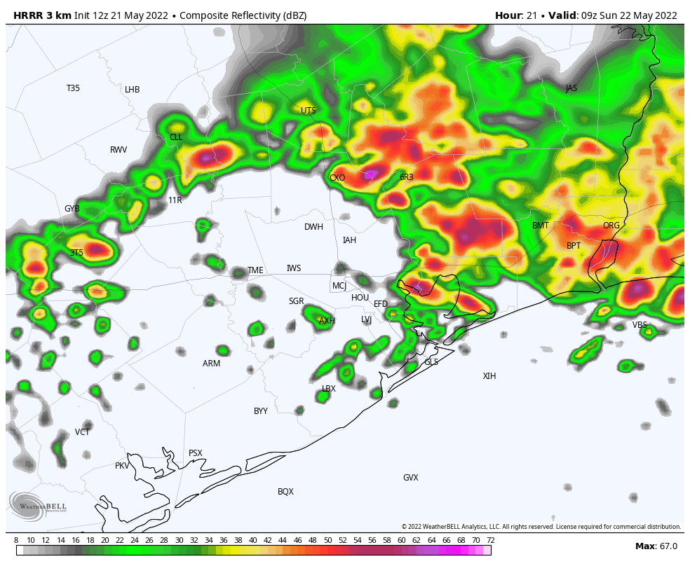
It looks like a (probably broken) line of storms will reach College Station around midnight, and then trudge down toward the coast by around sunrise. Probably the major threat is briefly strong straight-line winds, with the secondary potential for small hail. In terms of rainfall, accumulations will probably vary from a sprinkling to 1 inch or more of rain, with greater accumulations likely along and north of Interstate 10.
HRRR model radar reflectivity for 4 am CT on Sunday. (Weather Bell)
Sunday
There may be a lull in shower activity on Sunday morning before the potential for some on-and-off showers returns on Sunday afternoon. Highs should reach the mid- to upper-80s. Rain chances will fall back Sunday night.
Next week
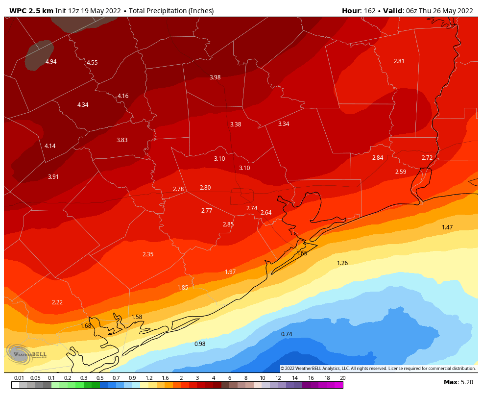
A healthy chance of rain returns Monday night and then may stay with us through Wednesday night as a series of disturbances moves through, culminating in a slightly stronger cold front on Wednesday night or some time Thursday. Rain accumulations for most should be 2 to 4 inches for now through next Thursday, which is welcome. And if we end up with a night or two in the 60s late next week, that will just be a huge bonus.
We’ll have a full post up Monday morning, as usual.
Averaging the temperature recorded in Houston (at Bush Airport) from May 1 through yesterday would give us the hottest front 19 days of May on record back to the 1890s. It’s probably not terribly surprising. We will begin to see things change this weekend, however, and it can’t come soon enough.
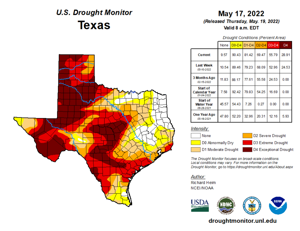
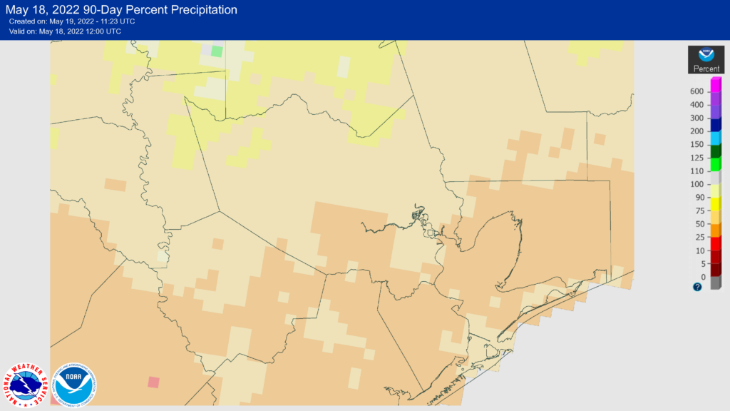
While the drought situation has held stable in the Houston area, across Texas, it continues to worsen. Almost 30 percent of the state is classified as being in “exceptional” drought, level 4 of 4. (NOAA)
The drought situation has not changed much in the Houston area since last week. We still see extreme drought creeping in across Wharton, Matagorda, and Brazoria Counties. It’s really the entire state of Texas that needs some help right now. Almost 30 percent of the state is classified as being in “exceptional” drought, the most coverage of that classification since early 2012, as we were coming out of the 2011 drought.
Our chance for help both locally and statewide is about to kick into gear. But it’s a bit of a tenuous story. I’ve been watching this wet pattern closely, and we started to see the European ensemble model backpedal a bit yesterday, taking us from about 2″ above normal the next 10 days or so down to 1″ above normal. While that may not sound like a huge change, this will go a long way toward relaxing drought, and any cutting back on that would not be great news. So, fingers crossed that the next week or so performs.
Today
The weather remains on autopilot for one more day: Sun, clouds, high humidity, and temperatures in the 90s. Winds will be up a bit today compared to recent days, with some 15 to 25 mph gusts possible. Perhaps that will help make it a bit less painful.
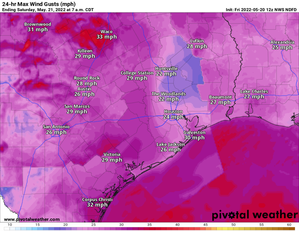
The wind will be a little gustier today than it has been this week, as slightly stronger onshore flow kicks into gear. (Pivotal Weather)
Most of us should stay dry, but perhaps a stray shower or storm could impact areas west of Houston later this afternoon.
Saturday
We should not see any significant weather changes tomorrow, but we may notice a few additional clouds. It should not be much cooler. In fact, with a cold front moving into Texas on Saturday but coming up short of Houston, that may actually allow for a little additional onshore flow or “compressional heating” ahead of the front, which could allow us to squeeze an extra degree or two out of the air tomorrow. Shower chances look minimal during the daylight hours right now. There may be a slightly better chance at storms tomorrow night, especially north of I-10.
Sunday
The big changes should really kick in on Sunday. The front will likely come up just short of Houston, but it will be close enough to the area to allow for numerous showers and storms to develop through the day on Sunday. Timing exactly where and when these will hit your backyard is impossible to do right now, but we believe most areas will see at least some rain at least once or twice on Sunday. And with a very, very humid air mass in place, any rain that does fall could be heavy, so keep alert for some localized street flooding if you’ll be out and about.
With rain and clouds, look for upper-80s or low-90s Sunday at best.
Monday & Tuesday
Weather modeling seems to agree that Monday may be a bit of a “down” day in terms of rain chances. So we may just see a few showers around with a mix of clouds and some sun. Look for highs in the upper-80s.
Tuesday should see another disturbance or two swing into the area, and that means that rain chances will probably trend up for that day. Look for scattered to numerous showers and storms with highs in the mid-80s. Again, any rain could be heavy.
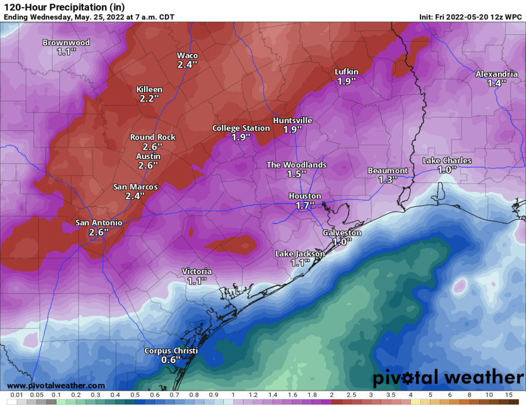
The current forecast calls for a general 1 to 3 inches of rain through Wednesday. Some areas will likely see more than that, while a few others may see under an inch. (Pivotal Weather)
How much rain through Wednesday morning? There will be a very wide variability with some places seeing an inch or less and others likely seeing 2 or 3 inches or even more. Consider this map an average, but you can clearly see we’re expecting a good bit of beneficial rain through Tuesday.
One other quick note: An early season Saharan dust cloud will work into our area on Tuesday into Wednesday, so you may see a hazier, dirtier looking sky in between storms. This isn’t uncommon in early summer, but it is a bit early for a dust event of this magnitude based on my experience. I would not read into it meaning anything in particular, however, as I don’t believe there’s any established correlation between early season dust and the upcoming hurricane season.
Later next week
Questions begin to arise later next week as to whether we can keep this wetter pattern going with daily shower and storm chances, or if things dial back a bit. Based on the latest data, I would expect a healthy chance of rain again on Wednesday before storm chances diminish a good bit on Thursday and Friday.
Memorial Weekend looks pretty good right now. Lower-end rain chances may build back in on Sunday or Monday, but as of now, it’s nothing too serious. We’ll keep tabs on it, but at this point, I would say at least 60 percent of the weekend looks great. It will be hot and humid, of course, with highs likely around 90 or a bit hotter. More next week!
There’s no question it has been a dry spring for the Houston area. Much of the region south of Interstate 10 has received less than 50 percent of normal rainfall, and this dry spell has come on top of an exceptionally hot May. Add these two factors together, and soils are rather dry heading into summer, which is a solid recipe for a significant drought. But summer is not fully here yet, and fortunately for us there’s a pattern change ahead this weekend that should bring some much-needed rainfall to the region before the onset of June.
Percent of rainfall received by the Houston area since mid-February. (NOAA)
Thursday
The rain isn’t here yet, however, and Houston will experience a few more blazing hot, sunny days before some relief arrives this weekend. Temperatures will reach the low 90s for most today, with mostly sunny skies, and a pronounced southerly flow. Look for winds out of the south at 10 to 15 mph, with gusts up to 25 mph. Lows tonight won’t drop below of the mid-70s for most.
Friday
This will be another hot and sunny day, with high temperatures in the low-90s and gusty southerly winds. With increasing clouds, look for a very muggy night Friday, with lows only dropping into the upper 70s.
Saturday
The weekend will start out with cloudy skies and muggy conditions as temperatures reach the lower 90s on Saturday. For the most part, I expect rain showers to hold off on Saturday, with the possible exception of areas well to our northwest, including College Station. This will be due to a slow moving, weakening cold front that is likely to reach the Houston metro area late Saturday night or early Sunday morning. For the most part, I don’t really expect much rain in the Houston region until after midnight.
Sunday
As the front moves into Houston and essentially stalls, we should see widespread showers and thunderstorms. Overall, I’m not expecting anything too extreme, with accumulations likely on the order of 0.25 to 1.0 inch for most. Highs on Sunday will probably reach the upper 80s beneath mostly cloudy skies. Lows on Sunday night should drop to near 70 degrees overnight.
Rain accumulation forecast for now through next Wednesday. (Weather Bell)
Early next week
The overall pattern for Monday through Wednesday is one where we have an unsettled atmosphere, with the remnants of the front hanging around, and disturbances passing overhead. With this kind of pattern I expect most of the region to pick up an additional 1 to 4 inches of rainfall through Wednesday. Highs should generally slot into the mid-80s with mostly cloudy skies. We should be back into the low 90s by the end of next week, with drier conditions. So for the sake of our region’s soils, and with apologies to those who have outdoor activities, I really hope the forecast for rainfall comes through next week.
Good morning. Our abnormally warm May weather continues, but I’m still expecting a modest break from the heat this weekend as well as the influx of some much needed rainfall. How much? We don’t yet know. But until then, it will feel a lot like June or even July outside.
Wednesday
As high pressure begins to sag eastward, we’ll see an onshore flow today that is a bit stronger, with southerly winds at 5 to 15 mph, at times gusting to 20 mph. Aside from that, there’s not a whole lot to say, with high temperatures topping out in the low- to mid-90s with mostly sunny skies. Conditions tonight will be warm, with lows in the mid-70s, generally, and partly cloudy skies.
High temperature forecast for Wednesday. (Weather Bell)
Thursday
If you liked Wednesday’s weather you’re in luck. Thursday is going to be just about the same.
Friday
High temperatures on Friday may be a degree or two cooler, and the southerly flow a little bit stronger. Sustained winds on Friday afternoon could reach as high as 20 mph, with gusts of 25 or 30 mph. Mostly sunny skies during the afternoon will give way to more clouds during the evening and this will make for a warm and sultry night. Look for lows to only fall to near 80 degrees in the city of Houston.
Saturday and Sunday
Saturday should start out warm, and mostly cloudy, with high temperatures reaching into the low 90s. After that we’re watching the movement of a slow-moving (and dying) cold front approaching our area. While the details remain fuzzy, rain chances should start to increase on Saturday evening into the overnight hours, with a healthy chance of rain persisting into Sunday. Most of the area should at least see some rain, perhaps a few tenths of an inch, but we certainly cannot rule out the potential for more localized heavy rainfall. Temperatures on Sunday will probably be in the 80s for most areas.
Don’t expect a significant cooldown with the front, as these forecast lows for Monday morning suggest. (Weather Bell)
Next week
It looks like what remains of the front will move off shore, allowing most of the region to stay in the 80s on Monday. But after that we’ll start to warm back up. While nothing is certain, it looks as though the pattern will support decent rain chances at least into the middle of next week. With June around the corner, several days of on-and-off rain sure would help with the region’s emergent drought.