Eric has been keeping you apprised on local impacts due to the upcoming cold snap and winter storm, which at this time appear to be relatively minor. We often get asked about weather across other portions of Texas, as people plan travel or have friends and relatives elsewhere. In this post, we’ll talk a bit more about what is expected weather-wise across the Lone Star State from this significant winter storm. It’s important to again underscore that this is not a February 2021 repeat, even elsewhere in Texas. All events have unique impacts. It’s not a reason to take events like this lightly, as this one will cause some significant problems I am sure, particularly related to travel. But it’s important for us to provide some context for you, and that context is that this is a not a February 2021-type event virtually anywhere in Texas.
North Texas & DFW Metro
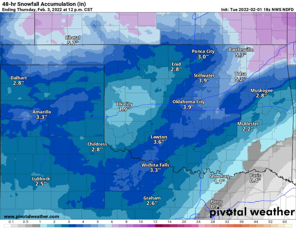
This winter storm will produce multiple hazards across Texas, and each area will have its own problems. In the Dallas-Fort Worth Metroplex, the concern is very much ice over anything else. Conditions will deteriorate later tomorrow afternoon and evening from northwest to southeast across the area, with rain transitioning to freezing rain (ice) and eventually sleet or snow. It may be a bit of a wild night Wednesday into Thursday morning with different areas seeing switches from ice to sleet to snow and back, eventually trending to all snow and sleet before ending on Thursday morning or afternoon.
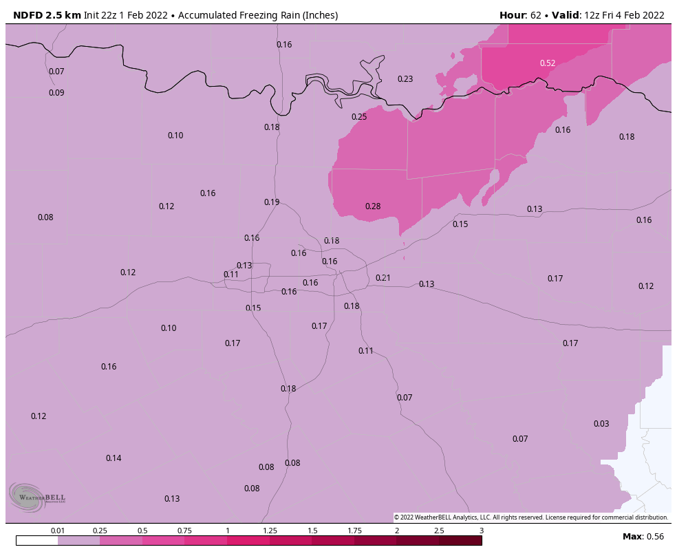
When all is said and done, most of the DFW area should see a tenth of an inch or two of ice, enough to cause significant travel problems and potentially some localized power outages or downed tree branches. North and east of Dallas is the highest concern. Modeling has been pretty consistent in pegging that area for higher ice accumulation (a quarter-inch or more), and that could lead to more significant travel problems and power outages. Travel to North Texas is not advised Wednesday night, Thursday, and potentially Friday, when things can hopefully begin to thaw out.
Less ice is expected east and southeast of Dallas, but there could also be some travel issues in far northern parts of the Piney Woods, particularly around Tyler and Longview. Patchy light ice is possible farther south toward Palestine, Nacogdoches, and Lufkin. Southeastern Oklahoma and portions of Arkansas will likely be hardest hit in terms of ice.
Snow and sleet are a little less of a concern than ice in Dallas, but it could still be significant, with perhaps 1 to 3 inches of accumulation on top of any ice, especially as you head out west of Fort Worth toward Weatherford and Mineral Wells. But the combination of everything will likely make for very, very difficult travel in North Texas late this week.
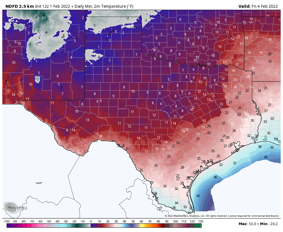
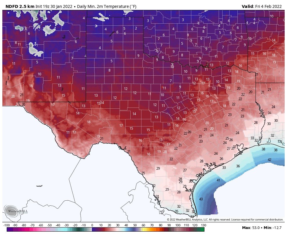
Overnight lows heading into Friday morning should bottom out in the teens in Dallas, the coldest night of this event (compared to -2 in February 2021).
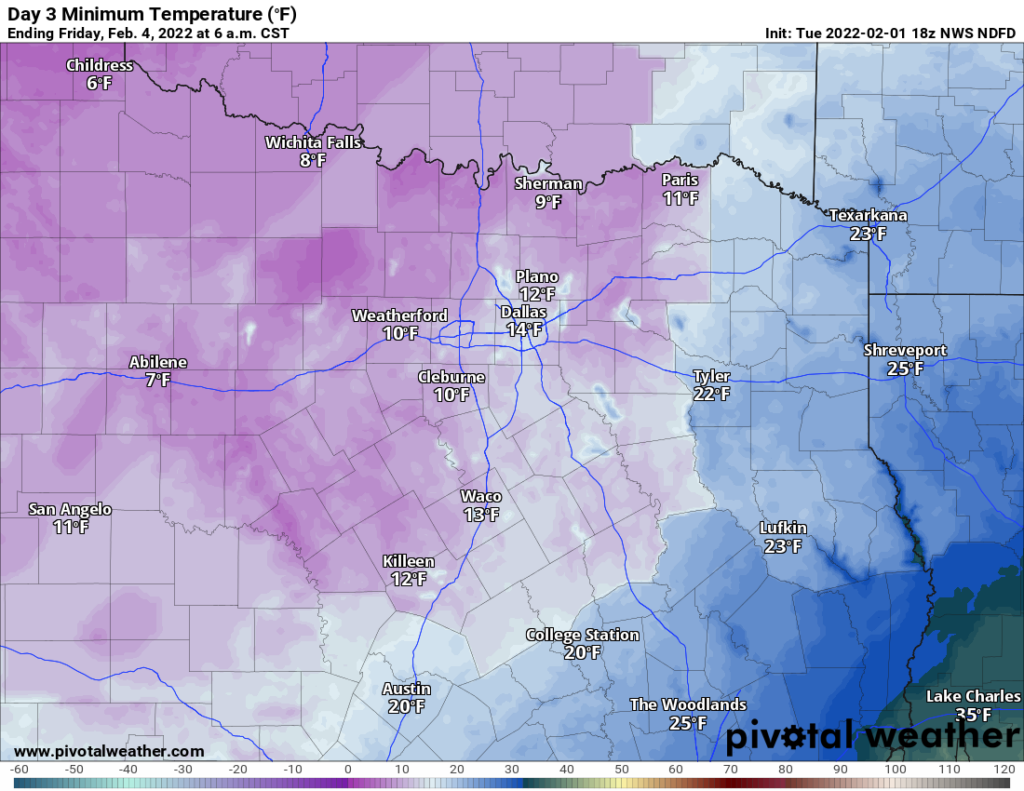
Single digits are possible well west of the Metroplex, heading toward Abilene or Wichita Falls, areas that will likely see less ice and about 2 to 3 inches of snow, which allows for more effective radiational cooling at night.
West Texas (El Paso, Midland, Lubbock, Amarillo)
For West Texas, the story will likely be snow and cold, with a little ice in spots as well. Snow will develop in the Panhandle late tonight, while a mix of precipitation should develop in the Permian Basin on Wednesday morning. The transition from a mix to all snow should gradually drop south and east tomorrow night, reaching I-10 west of Hill Country around midnight before snow gradually winds down. Blizzard conditions are possible in some of the mountains in far West Texas, so a hike in Guadalupe Mountains National Park would be ill-advised.
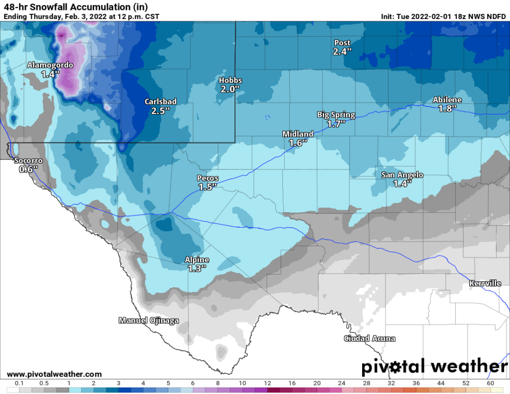
When all is said and done, most southern areas will see a modest 1 to 3 inches, with locally higher amounts in the mountains but plenty of blowing snow as well. Additionally, up to a tenth of an inch of ice will be possible in some spots.
In the Panhandle, generally 1 to 3 inches and blowing snow is expected, with a few higher amounts, especially north of Amarillo. You can see some discontinuities in the map below, which are related to the general uncertainty that’s always present in Southern Plains winter storms. Each National Weather Service office relies on their experience and model trends to produce these forecasts, so there are bound to be some differences from place to place. I show these to give you a general idea of expectations and some granularity.
Temperatures will be quite cold in West Texas, with lows in the single digits to below zero expected on Friday morning in the Panhandle and single digits to teens in southwest Texas.
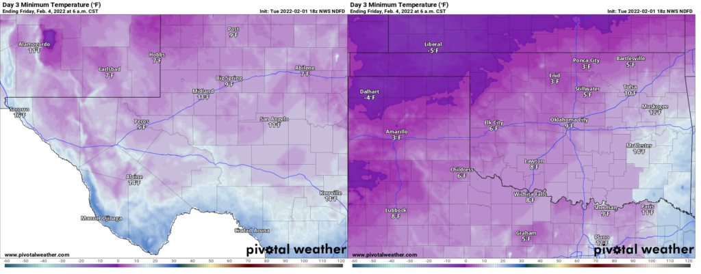
In some cases, while these temperatures are quite cold, they will fall 10 degrees or more short of last February’s coldest readings. Again, while this is a big storm, it’s not historic in the way last February was.
Central Texas (Austin, San Antonio, Waco)
As is often the case, the farther south and east you go, the harder the forecast gets in Texas winter storms. Central Texas is no exception this time around, with models painting a challenging forecast, particularly over Waco and Austin. A mix of rain, ice, and possibly sleet will arrive late Wednesday night and Thursday, slowly transitioning over to sleet or mixed sleet and snow late Thursday. While the duration of precipitation should be relatively brief here compared to other parts of Texas, there is still some chance that ice overperforms some, particularly from Austin through Waco.
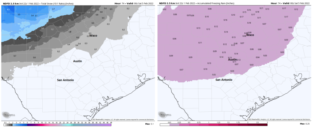
In general, most of Hill Country and the I-35 corridor north of New Braunfels should see 0.05 to 0.10 inches of ice, enough to create some hazardous travel on Thursday into at least Friday morning. It’s not out of the question that a few isolated spots, particularly north of Killeen through Waco could see upwards of two-tenths of an inch of ice, which would cause more substantial issues. Whatever happens, ice is expected to be an issue north of San Antonio on Thursday and travel is not advised Thursday into at least Friday morning.
Morning lows on Friday will be quite chilly.
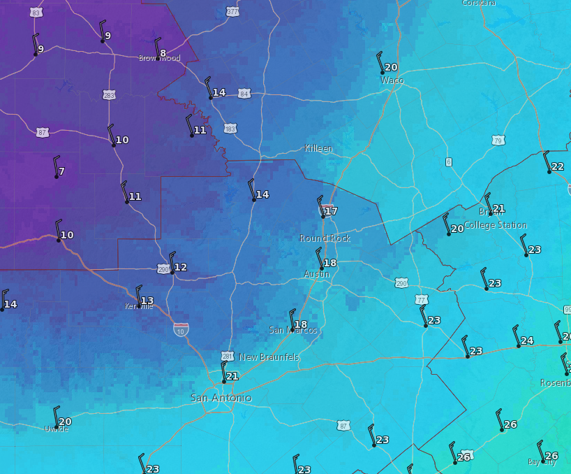
Expect lows to again come up well short of February 2021’s levels in Central Texas, with San Antonio, Austin, and Waco all within a few degrees of 20 on Friday morning.
South Texas
No serious winter impacts outside of cold and wind are expected in South Texas, thankfully. However, Friday morning will certainly be cold in the Valley and toward Victoria and Corpus Christi.
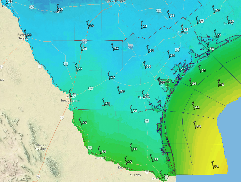
At this time, icing is not expected south and east of San Antonio, but a few reports of light icing or sleet can’t be entirely ruled out, especially in the Victoria Crossroads.
Eric will have the latest on our Houston area expectations in the morning!